Select location of well to view details.
Click on column heading to sort.
|
|
|
County: Osage Select location of well to view details. Click on column heading to sort. |
|
|
|
| View page: 1 || 2 || 3 || 4 || 5 || 6 || 7 || 8 || 9 || 10 || Next > | |||||||||
| T-R-S | Owner | Well Depth Ascend. Desc. |
Static Water Level Ascend. Desc. |
Est. Yield Ascend. Desc. |
Well Use | Other ID | Action Taken | Completion Date Ascend. Desc. |
Scan? |
|
T17S, R17E, Sec. 6 SW SW SW |
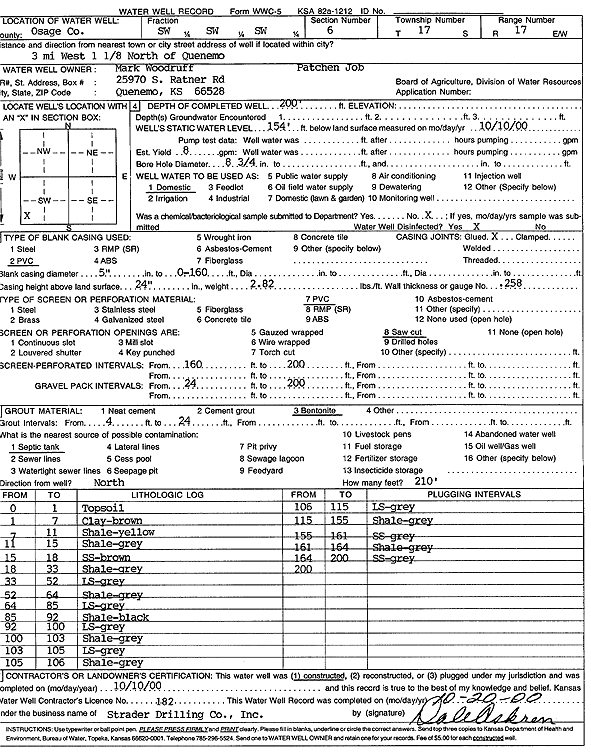
Woodruff, Mark | 200 ft. | 154 ft. | 8 gpm. | Domestic | Constructed | 10-Oct-2000 | Scan | |
|
T17S, R17E, Sec. 7 SW NW |
Duffle, Andy | 200 ft. | 100 ft. | 6 gpm. | Domestic | Constructed | 25-Mar-1977 | ||
|
T17S, R17E, Sec. 8 NW NW NW |
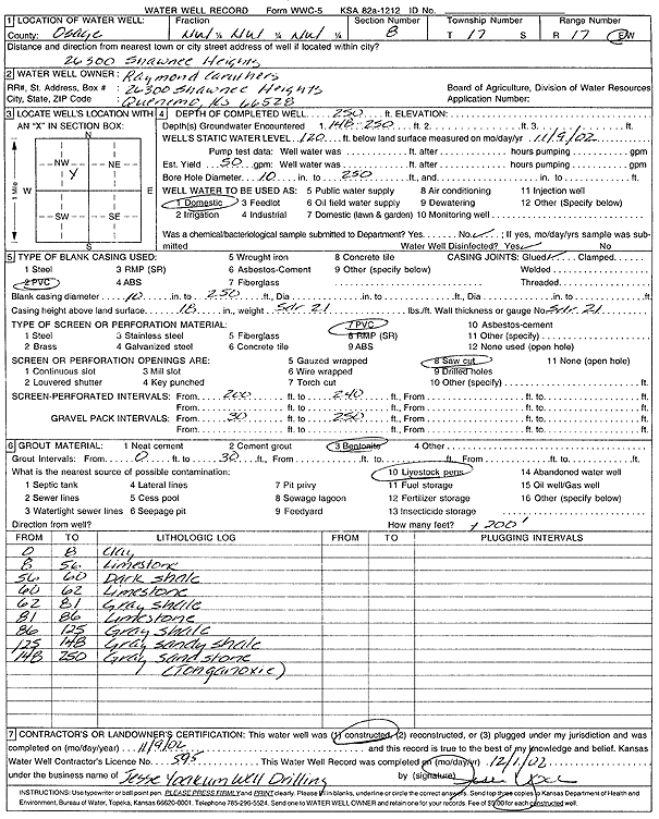
Caruthers, Raymond | 250 ft. | 120 ft. | 50 gpm. | Domestic | Constructed | 09-Nov-2002 | Scan | |
|
T17S, R17E, Sec. 8 SE SE SW |
Sluder | 225 ft. | 18 gpm. | Domestic | Plugged | 19-Jul-1989 | |||
|
T17S, R17E, Sec. 9 SE SE SE |
City of Quenemo | 31 ft. | 13 ft. | Public Water Supply | Well 4 | Plugged | 27-Oct-2005 | ||
|
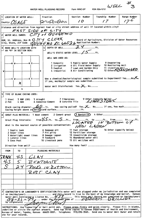
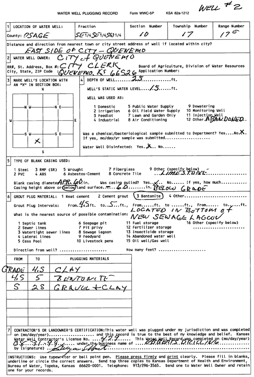
T17S, R17E, Sec. 10 SE SE SW |
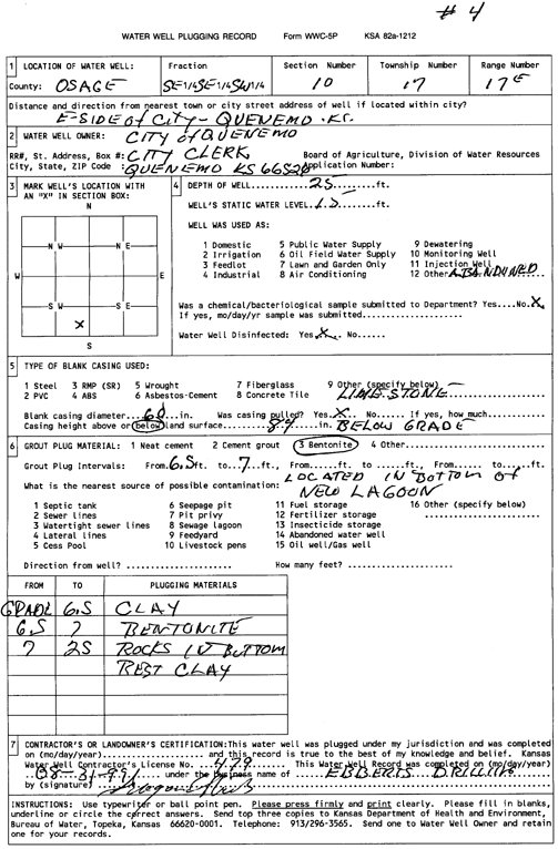
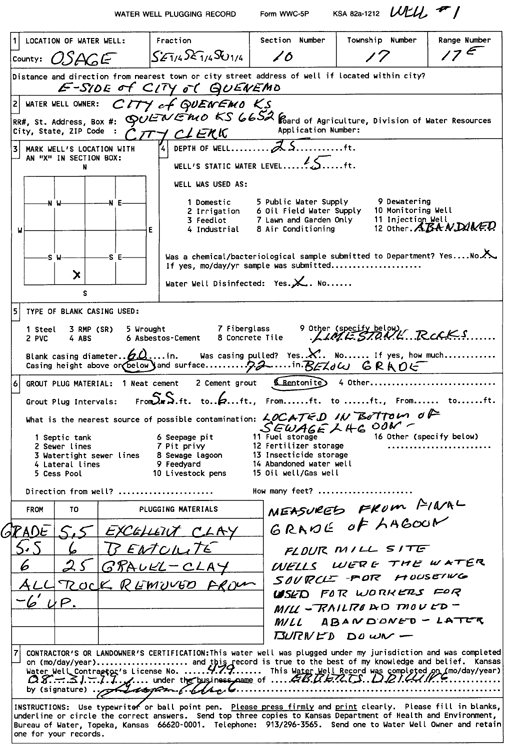
City of Quenemo | 25 ft. | 15 ft. | (unstated)/abandoned | Plugged | 31-Aug-1999 | Scan | ||
|
T17S, R17E, Sec. 10 SE SE SW |
City of Quenemo | 25 ft. | 15 ft. | (unstated)/abandoned | Plugged | 31-Aug-1999 | Scan | ||
|
T17S, R17E, Sec. 10 SE SE SW |
City of Quenemo | 24 ft. | 15 ft. | (unstated)/abandoned | Plugged | 31-Aug-1999 | Scan | ||
|
T17S, R17E, Sec. 10 SE SE SW |
City of Quenemo | 25 ft. | 15 ft. | (unstated)/abandoned | Plugged | 31-Aug-1999 | Scan | ||
|
T17S, R17E, Sec. 10 SW SW SW |
City of Quenemo | 200 ft. | 120 ft. | Public Water Supply | Plugged | 05-Jun-1996 | Scan | ||
|
T17S, R17E, Sec. 10 SW SW SW |
City of Quenemo | 40 ft. | 20 ft. | Public Water Supply | Plugged | 05-Jun-1996 | Scan | ||
|
T17S, R17E, Sec. 10 SW SW SW |
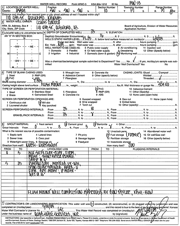
Lewis Conoco | 19 ft. | 6.39 ft. | Monitoring well/observation/piezometer | MW 10 R | Constructed | 15-Jun-2010 | ||
|
T17S, R17E, Sec. 10 SW SW SW |
Lewis Conoco | 15 ft. | 8.15 ft. | Monitoring well/observation/piezometer | MW 16 | Constructed | 15-Jun-2010 | ||
|
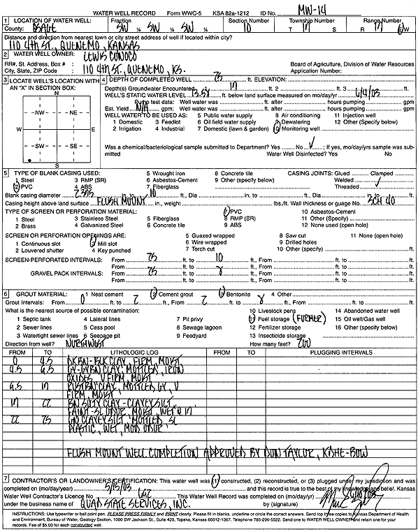
T17S, R17E, Sec. 10 SW SW SW |
Lewis Conoco | 25 ft. | 13.58 ft. | Monitoring well/observation/piezometer | MW 14 | Constructed | 15-May-2003 | Scan | |
|
T17S, R17E, Sec. 10 SW SW SW |
Lewis Conoco | 15 ft. | 7.8 ft. | Monitoring well/observation/piezometer | MW 1 R | Constructed | 15-Jun-2010 | ||
|
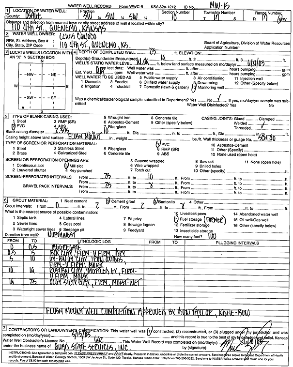
T17S, R17E, Sec. 10 SW SW SW |
Lewis Conoco | 25 ft. | 14.09 ft. | Monitoring well/observation/piezometer | MW 15 | Constructed | 15-May-2003 | Scan | |
|
T17S, R17E, Sec. 10 SW SW SW |
Lewis Conoco | 25 ft. | 13.25 ft. | Monitoring well/observation/piezometer | MW 13 | Constructed | 14-May-2003 | Scan | |
|
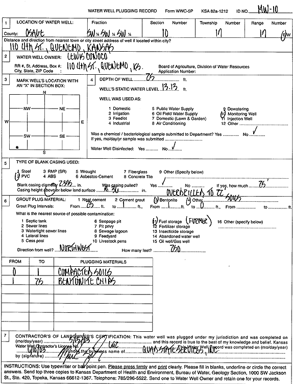
T17S, R17E, Sec. 10 SW SW SW |
Lewis Conoco | 25 ft. | 13.13 ft. | Monitoring well/observation/piezometer | MW 10 | Plugged | 15-May-2003 | Scan | |
|
T17S, R17E, Sec. 10 SW SW SW |
Lewis Conoco | 23 ft. | Monitoring well/observation/piezometer | OBWIB | Constructed | 13-Sep-1994 | |||
|
T17S, R17E, Sec. 10 SW SW SW |
Lewis Conoco | 30 ft. | Monitoring well/observation/piezometer | MW 12 | Constructed | 13-Sep-1995 | |||
|
T17S, R17E, Sec. 10 SW SW SW |
Lewis Conoco | 17 ft. | Monitoring well/observation/piezometer | VEW | Constructed | 13-Sep-1994 | |||
|
T17S, R17E, Sec. 10 SW SW SW |
Lewis Conoco | 17 ft. | Monitoring well/observation/piezometer | VOBW 3 | Constructed | 13-Sep-1994 | |||
|
T17S, R17E, Sec. 10 SW SW SW |
Lewis Conoco | 17 ft. | Monitoring well/observation/piezometer | VOBW 1 | Constructed | 13-Sep-1994 | |||
|
T17S, R17E, Sec. 10 SW SW SW |
Lewis Conoco | 35 ft. | Monitoring well/observation/piezometer | OBW 2 | Constructed | 12-Sep-1994 | |||
|
T17S, R17E, Sec. 10 SW SW SW |
Lewis Conoco | 17 ft. | Monitoring well/observation/piezometer | VOBW 2 | Constructed | 12-Sep-1994 | |||
|
T17S, R17E, Sec. 10 SW SW SW |
Lewis Conoco | 30 ft. | Monitoring well/observation/piezometer | MW 11 | Constructed | 14-Sep-1994 | |||
|
T17S, R17E, Sec. 10 SW SW SW |
Lewis Conoco | 40 ft. | Monitoring well/observation/piezometer | PTWI | Constructed | 20-Sep-1994 | |||
|
T17S, R17E, Sec. 10 SW SW SW |
Lewis Conoco | 30.55 ft. | 20.36 ft. | Monitoring well/observation/piezometer | MW 11 | Plugged | 22-Sep-2015 | ||
|
T17S, R17E, Sec. 10 SW SW SW |
Lewis Conoco | 20.02 ft. | 17.19 ft. | Monitoring well/observation/piezometer | MW 16 R | Plugged | 22-Sep-2015 | ||
|
T17S, R17E, Sec. 10 SW SW SW |
Lewis Conoco | 20 ft. | 17.11 ft. | Monitoring well/observation/piezometer | MW 2 R | Plugged | 22-Sep-2015 | ||
|
T17S, R17E, Sec. 10 SW SW SW |
Lewis Conoco | 30 ft. | Monitoring well/observation/piezometer | Constructed | 13-Sep-1994 | ||||
|
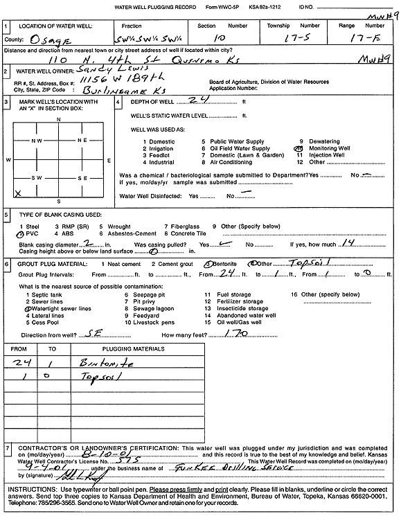
T17S, R17E, Sec. 10 SW SW SW |
Lewis, Sandy | 30 ft. | Monitoring well/observation/piezometer | MW 2 | Plugged | 10-Aug-2001 | Scan | ||
|
T17S, R17E, Sec. 10 SW SW SW |
Lewis, Sandy | 30 ft. | 12 ft. | 2 gpm. | Monitoring well/observation/piezometer | Constructed | 02-Aug-1993 | ||
|
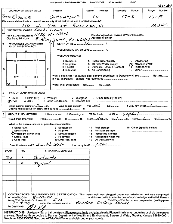
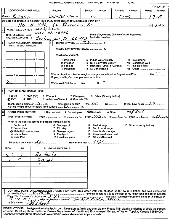
T17S, R17E, Sec. 10 SW SW SW |
Lewis, Sandy | 25 ft. | Monitoring well/observation/piezometer | MW 7 | Plugged | 10-Aug-2001 | Scan | ||
|
T17S, R17E, Sec. 10 SW SW SW |
Lewis, Sandy | 30 ft. | 12 ft. | 2 gpm. | Monitoring well/observation/piezometer | Constructed | 03-Aug-1993 | ||
|
T17S, R17E, Sec. 10 SW SW SW |
Lewis, Sandy | 24 ft. | Monitoring well/observation/piezometer | MW 9 | Plugged | 10-Aug-2001 | Scan | ||
|
T17S, R17E, Sec. 10 SW SW SW |
Lewis, Sandy | 25 ft. | 15.3 ft. | Monitoring well/observation/piezometer | Constructed | 03-Nov-1993 | |||
|
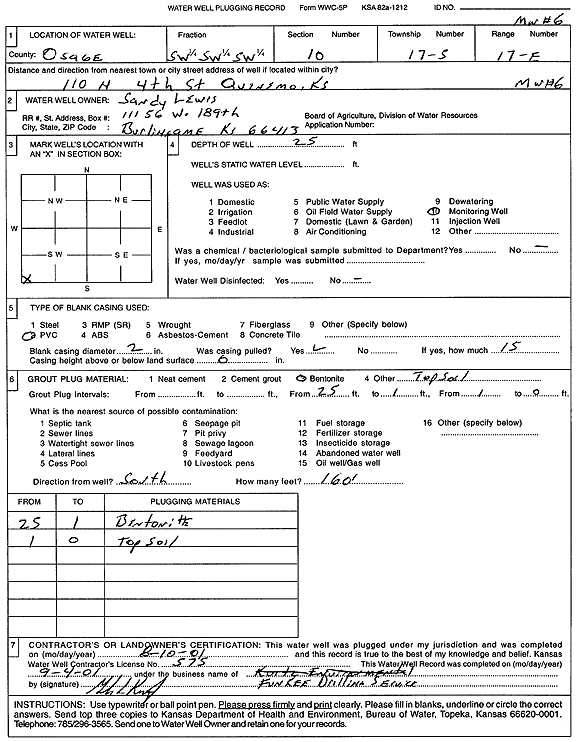
T17S, R17E, Sec. 10 SW SW SW |
Lewis, Sandy | 25 ft. | Monitoring well/observation/piezometer | MW 6 | Plugged | 10-Aug-2001 | Scan | ||
|
T17S, R17E, Sec. 10 SW SW SW |
Lewis, Sandy | 25 ft. | 12 ft. | Monitoring well/observation/piezometer | Constructed | 03-Aug-1993 | |||
|
T17S, R17E, Sec. 10 SW SW SW |
Lewis, Sandy | 25 ft. | 13.7 ft. | Monitoring well/observation/piezometer | Constructed | 03-Nov-1993 | |||
|
T17S, R17E, Sec. 10 SW SW SW |
Lewis, Sandy | 25 ft. | 12 ft. | 2 gpm. | Monitoring well/observation/piezometer | Constructed | 03-Aug-1993 | ||
|
T17S, R17E, Sec. 10 SW SW SW |
Lewis, Sandy | 30 ft. | 12 ft. | 3 gpm. | Monitoring well/observation/piezometer | Constructed | 03-Aug-1993 | ||
|
T17S, R17E, Sec. 10 SW SW SW |
Lewis, Sandy | 25 ft. | 14.1 ft. | Monitoring well/observation/piezometer | Constructed | 03-Nov-1993 | |||
|
T17S, R17E, Sec. 10 SW SW SW |
Lewis, Sandy | 25 ft. | 12.6 ft. | Monitoring well/observation/piezometer | Constructed | 03-Nov-1993 | |||
|
T17S, R17E, Sec. 10 SW SW SW |
Lewis, Sandy | 30 ft. | 11 ft. | 2 gpm. | Monitoring well/observation/piezometer | Constructed | 03-Aug-1993 | ||
|
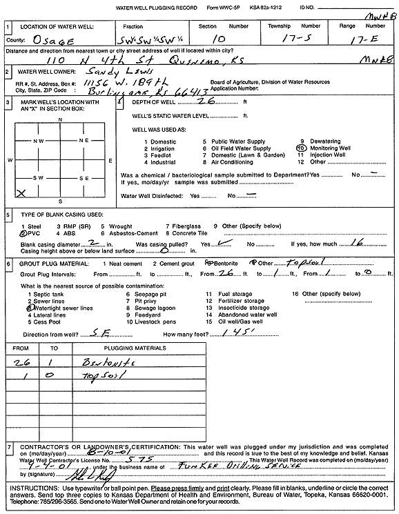
T17S, R17E, Sec. 10 SW SW SW |
Lewis, Sandy | 26 ft. | Monitoring well/observation/piezometer | MW 8 | Plugged | 10-Aug-2001 | Scan | ||
|
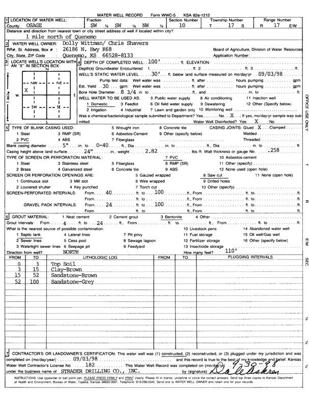
T17S, R17E, Sec. 10 SW SW NW |
Wittman, Dolly/Shavers, Chris | 100 ft. | 30 ft. | 30 gpm. | Domestic | Constructed | 03-Sep-1998 | Scan | |
|
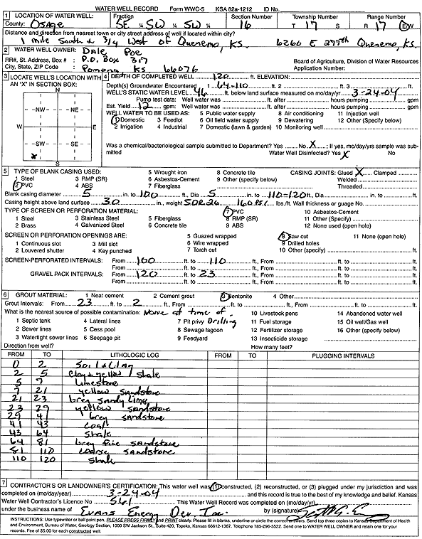
T17S, R17E, Sec. 16 SE SW SW |
Poe, Dale | 120 ft. | 46 ft. | 12 gpm. | Domestic | Constructed | 24-Mar-2004 | Scan | |
|
T17S, R17E, Sec. 17 NW NW NW |
Wall, George | 240 ft. | 90 ft. | 30 gpm. | Domestic | Constructed | 03-Oct-1995 | ||
|
T17S, R17E, Sec. 19 NE NE SE |
Bent, Jim | 207 ft. | 112 ft. | 20 gpm. | Domestic | Constructed | 13-Nov-1995 | ||
| View page: 1 || 2 || 3 || 4 || 5 || 6 || 7 || 8 || 9 || 10 || Next > | |||||||||