Select location of well to view details.
Click on column heading to sort.
|
|
|
County: Butler Select location of well to view details. Click on column heading to sort. |
|
|
|
| View page: < Prev || 51 || 52 || 53 || 54 || 55 || 56 || 57 || 58 || 59 || 60 || Next > | |||||||||
| T-R-S | Owner | Well Depth Ascend. Desc. |
Static Water Level Ascend. Desc. |
Est. Yield Ascend. Desc. |
Well Use | Other ID | Action Taken | Completion Date Ascend. Desc. |
Scan? |
|
T26S, R5E, Sec. 24 NE NE NW |
Thompson, Terry L. | 119 ft. | 41 ft. | Domestic | Plugged | 27-Jan-1996 | |||
|
T26S, R5E, Sec. 25 NE NW NE |
Hobson, RAE | 144 ft. | 34 ft. | 2 gpm. | Domestic | Constructed | 12-Oct-1977 | ||
|
T26S, R5E, Sec. 26 SE SW SW |
Radebaugh, Dale | 45 ft. | 30 ft. | Domestic | Plugged | 31-Jul-2009 | |||
|
T26S, R5E, Sec. 28 SW SE NW |
Butler County | 30 ft. | 20 ft. | Monitoring well/observation/piezometer | P 5 | Constructed | 06-Jul-1995 | ||
|
T26S, R5E, Sec. 28 SE SE NW |
Butler County | 27 ft. | 15 ft. | Monitoring well/observation/piezometer | P 8 | Constructed | 08-Jul-1995 | ||
|
T26S, R5E, Sec. 28 NW NW SW |
Butler County | 23.5 ft. | 3.5 ft. | Monitoring well/observation/piezometer | P 9 | Constructed | 10-Jul-1995 | ||
|
T26S, R5E, Sec. 28 NW SE NW |
Butler County | 53.1 ft. | 42 ft. | Monitoring well/observation/piezometer | P 5D | Constructed | 03-Aug-1995 | ||
|
T26S, R5E, Sec. 28 SW SE NW |
Butler County | 25 ft. | 11 ft. | Monitoring well/observation/piezometer | P 3 | Constructed | 07-Jul-1995 | ||
|
T26S, R5E, Sec. 28 NW SE NW |
Butler County | 18 ft. | 15 ft. | Monitoring well/observation/piezometer | P 4 | Constructed | 08-Jul-1995 | ||
|
T26S, R5E, Sec. 28 NW NE SW |
Butler County | 28 ft. | 14.5 ft. | Monitoring well/observation/piezometer | P 10 | Constructed | 07-Jul-1995 | ||
|
T26S, R5E, Sec. 28 NW SW NW |
Butler County | 18 ft. | Monitoring well/observation/piezometer | P 1A | Constructed | 10-Jul-1995 | |||
|
T26S, R5E, Sec. 28 SE SE NW |
Butler County | 57.2 ft. | 46 ft. | Monitoring well/observation/piezometer | P 10D | Constructed | 03-Aug-1995 | ||
|
T26S, R5E, Sec. 28 NE NW SW |
Butler County | 30 ft. | 14 ft. | Monitoring well/observation/piezometer | P 7 | Constructed | 10-Jul-1995 | ||
|
T26S, R5E, Sec. 28 SW SW NW |
Butler County | 14 ft. | Monitoring well/observation/piezometer | P 6 | Constructed | 05-Jul-1995 | |||
|
T26S, R5E, Sec. 28 NW SW NW |
Butler County | 94.3 ft. | 83 ft. | Monitoring well/observation/piezometer | P 1D | Constructed | 03-Aug-1995 | ||
|
T26S, R5E, Sec. 28 NW SW NW |
Butler County | 11 ft. | Monitoring well/observation/piezometer | P 1 | Constructed | 06-Jul-1995 | |||
|
T26S, R5E, Sec. 28 SW SW NW |
Butler County | 45.9 ft. | 35 ft. | Monitoring well/observation/piezometer | P 6D | Constructed | 03-Aug-1995 | ||
|
T26S, R5E, Sec. 28 NE SE NW |
Butler County | 53.6 ft. | 43 ft. | Monitoring well/observation/piezometer | P 8D | Constructed | 03-Aug-1995 | ||
|
T26S, R5E, Sec. 28 NE SE NW |
Butler County | 30 ft. | 17 ft. | Monitoring well/observation/piezometer | P 2 | Constructed | 09-Jul-1995 | ||
|
T26S, R5E, Sec. 28 SE SE NW |
Butler County | 20 ft. | Monitoring well/observation/piezometer | P 8 | Constructed | 07-Jul-1995 | |||
|
T26S, R5E, Sec. 28 NW NW |
Butler County Landfill | 18 ft. | 14.7 ft. | Monitoring well/observation/piezometer | MW 4 | Constructed | 27-Oct-1993 | ||
|
T26S, R5E, Sec. 28 NW NE SW NW |
Butler County Landfill | 24 ft. | 10 ft. | Monitoring well/observation/piezometer | MW 3 | Plugged | 25-Mar-2020 |
KOLAR |
|
|
T26S, R5E, Sec. 28 NE NW NW |
Butler County Landfill | 16 ft. | Monitoring well/observation/piezometer | MW 16 | Constructed | 23-Sep-1996 | |||
|
T26S, R5E, Sec. 28 NW SW NW |
Butler County Landfill | 11 ft. | Monitoring well/observation/piezometer | GM 3 | Constructed | 23-Sep-1996 | |||
|
T26S, R5E, Sec. 28 NW NW |
Butler County Landfill | 21 ft. | 8.9 ft. | Monitoring well/observation/piezometer | MW 1 | Constructed | 26-Oct-1993 | ||
|
T26S, R5E, Sec. 28 SE SW NW |
Butler County Landfill | 22 ft. | Monitoring well/observation/piezometer | Plugged | 25-Sep-1996 | ||||
|
T26S, R5E, Sec. 28 SW SW NW NW |
Butler County Landfill | 18 ft. | 14 ft. | Monitoring well/observation/piezometer | MW 4 | Plugged | 25-Mar-2020 |
KOLAR |
|
|
T26S, R5E, Sec. 28 NW SW NW |
Butler County Landfill | 16 ft. | Monitoring well/observation/piezometer | GM 2 | Constructed | 23-Sep-1996 | |||
|
T26S, R5E, Sec. 28 SW SW NW |
Butler County Landfill | 31 ft. | Monitoring well/observation/piezometer | MW 15 | Constructed | 24-Sep-1996 | |||
|
T26S, R5E, Sec. 28 NW NW |
Butler County Landfill | 30 ft. | 19.3 ft. | Monitoring well/observation/piezometer | MW 2 | Constructed | 26-Oct-1993 | ||
|
T26S, R5E, Sec. 28 NW NW |
Butler County Landfill | 22 ft. | 15 ft. | Monitoring well/observation/piezometer | MW 3 | Constructed | 31-Oct-1993 | ||
|
T26S, R5E, Sec. 28 NW NW |
Butler County Landfill | 28.5 ft. | 21.5 ft. | Monitoring well/observation/piezometer | MW 5 | Constructed | 26-Oct-1993 | ||
|
T26S, R5E, Sec. 28 NE SW NW |
Butler County Landfill | 28 ft. | Monitoring well/observation/piezometer | MW 14 | Constructed | 24-Sep-1996 | |||
|
T26S, R5E, Sec. 28 NE SE NW |
Butler County Landfill | 21 ft. | 20 ft. | (unstated)/abandoned | Plugged | 01-Jan-2006 | |||
|
T26S, R5E, Sec. 28 SE SW |
Butler County Landfill | 20 ft. | 17.3 ft. | Monitoring well/observation/piezometer | MW 21 | Constructed | 18-Aug-2004 | ||
|
T26S, R5E, Sec. 28 NE SE NW |
Butler County Landfill | 45 ft. | 35 ft. | (unstated)/abandoned | Plugged | 01-Jan-2006 | |||
|
T26S, R5E, Sec. 28 NE NE NW |
Butler County Landfill | 15 ft. | 3 ft. | Monitoring well/observation/piezometer | Plugged | 27-Nov-2006 | |||
|
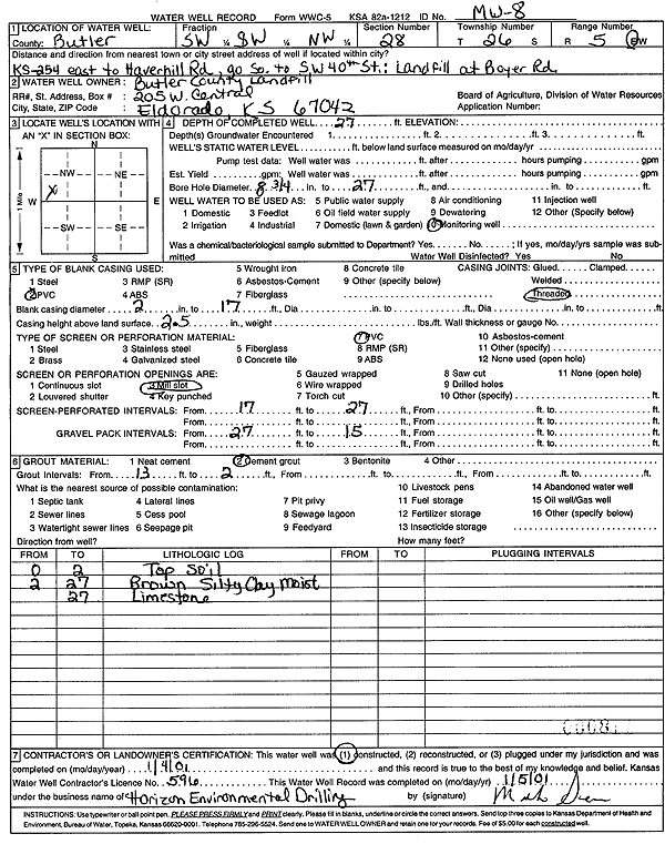
T26S, R5E, Sec. 28 SW SW NW |
Butler County Landfill | 27 ft. | Monitoring well/observation/piezometer | MW 8 | Constructed | 04-Jan-2001 | Scan | ||
|
T26S, R5E, Sec. 28 NE SW NW |
Butler County Landfill | 64 ft. | 40 ft. | (unstated)/abandoned | Plugged | 01-Jan-2006 | |||
|
T26S, R5E, Sec. 28 SE NW |
Butler County Landfill | 27 ft. | Monitoring well/observation/piezometer | Plugged | 18-Aug-2004 | ||||
|
T26S, R5E, Sec. 28 NW NE NW |
Butler County Landfill | 14 ft. | 3 ft. | Monitoring well/observation/piezometer | Plugged | 27-Nov-2006 | |||
|
T26S, R5E, Sec. 28 NW SW NW |
Butler County Landfill | 15 ft. | Monitoring well/observation/piezometer | GM 1 | Constructed | 23-Sep-1996 | |||
|
T26S, R5E, Sec. 28 NE SW NW |
Butler County Landfill | 18 ft. | Monitoring well/observation/piezometer | P 4 | Plugged | 25-Sep-1996 | |||
|
T26S, R5E, Sec. 28 SE SE NE |
Murphy, Tim | 125 ft. | 5 gpm. | Domestic, Lawn and Garden | Constructed | 04-May-2012 | |||
|
T26S, R5E, Sec. 28 SE SE SE |
Schwemmer, Vickie | 33 ft. | 1 ft. | (unstated)/abandoned | Plugged | 30-Nov-2011 | |||
|
T26S, R5E, Sec. 29 NE SW NE |
Fanning, Jim | 145 ft. | 25 ft. | 15 gpm. | Domestic, Lawn and Garden | Constructed | 01-Jul-1986 | ||
|
T26S, R5E, Sec. 29 SE NW SW |
Wright, Bob | 125 ft. | 40 ft. | 10 gpm. | Domestic, Lawn and Garden | Constructed | 01-May-1991 | ||
|
T26S, R5E, Sec. 30 SE SW NW |
Jones, Kent | 125 ft. | 40 ft. | 25 gpm. | Domestic | Constructed | 17-Jun-1992 | ||
|
T26S, R5E, Sec. 32 SW SW SW |
Beard, Ralph | 75 ft. | 35 ft. | .83 gpm. | Domestic | Reconstructed | 18-Aug-1981 | ||
|
T26S, R5E, Sec. 34 N2 NW SW |
Budick, Fred | 120 ft. | 27 ft. | 1 gpm. | Domestic | Constructed | 01-Sep-1978 | ||
| View page: < Prev || 51 || 52 || 53 || 54 || 55 || 56 || 57 || 58 || 59 || 60 || Next > | |||||||||