Select location of well to view details.
Click on column heading to sort.
|
|
|
County: Rawlins Select location of well to view details. Click on column heading to sort. |
|
|
|
| View page: 1 || 2 || 3 || 4 || 5 || 6 || 7 || 8 || 9 || 10 || Next > | |||||||||
| T-R-S | Owner | Well Depth Ascend. Desc. |
Static Water Level Ascend. Desc. |
Est. Yield Ascend. Desc. |
Well Use | Other ID | Action Taken | Completion Date Ascend. Desc. |
Scan? |
|
T2S, R31W, Sec. 3 NE NW SE |
Decatur Coop Assoc. | 23.5 ft. | 23.5 ft. | Monitoring well/observation/piezometer | MW 4 | Plugged | 25-Jul-2006 | ||
|
T2S, R31W, Sec. 3 SE NE NW |
Decatur Coop Assoc. | 19.5 ft. | Environmental Remediation, Soil Vapor Extraction | SV 2 | Plugged | 25-Jul-2006 | |||
|
T2S, R31W, Sec. 3 SE NE NW |
Decatur Coop Assoc. | 24.5 ft. | Environmental Remediation, Soil Vapor Extraction | SV 1 | Plugged | 26-Jul-2006 | |||
|
T2S, R31W, Sec. 3 SE NE NW |
Decatur Coop Assoc. | 25 ft. | 20.98 ft. | Environmental Remediation, Soil Vapor Extraction | SVE 1 | Constructed | 10-Jul-2002 | Scan | |
|
T2S, R31W, Sec. 3 SE NE NW |
Decatur Coop Assoc. | 25 ft. | 21.2 ft. | Environmental Remediation, Soil Vapor Extraction | SVE 2 | Constructed | 10-Jul-2002 | Scan | |
|
T2S, R31W, Sec. 3 SE NE NW |
Decatur Coop Assoc. | 30 ft. | Environmental Remediation, Air Sparge | AS 1 | Constructed | 10-Jul-2002 | Scan | ||
|
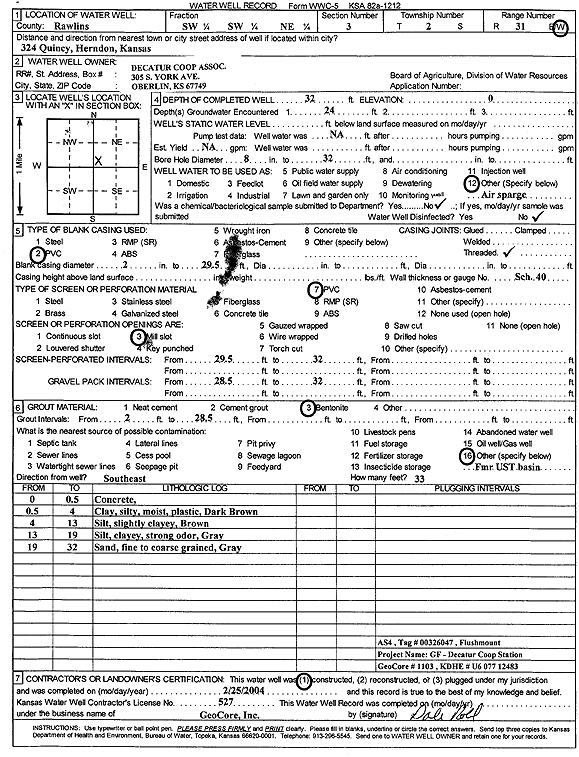
T2S, R31W, Sec. 3 SW SW NE |
Decatur Coop Assoc. | 32 ft. | Environmental Remediation, Air Sparge | AS 4 | Constructed | 25-Feb-2004 | Scan | ||
|
T2S, R31W, Sec. 3 SW SW NE |
Decatur Coop Assoc. | 35 ft. | 26 ft. | Environmental Remediation, Air Sparge | AS 3 | Plugged | 26-Jul-2006 | ||
|
T2S, R31W, Sec. 3 SW SW NE |
Decatur Coop Assoc. | 27.5 ft. | 25.5 ft. | Monitoring well/observation/piezometer | MW 2 | Plugged | 26-Jul-2006 | ||
|
T2S, R31W, Sec. 3 SE NE NW |
Decatur Coop Assoc. | 25 ft. | Environmental Remediation, Soil Vapor Extraction | SV 2 | Plugged | 26-Jul-2006 | |||
|
T2S, R31W, Sec. 3 SW SW NE |
Decatur Coop Assoc. | 29 ft. | 26 ft. | Monitoring well/observation/piezometer | MW 1 | Plugged | 26-Jul-2006 | ||
|
T2S, R31W, Sec. 3 SE NE NW |
Decatur Coop Assoc. | 20.5 ft. | Environmental Remediation, Soil Vapor Extraction | SV 1 | Plugged | 25-Jul-2006 | |||
|
T2S, R31W, Sec. 3 SE NE NW |
Decatur Coop Assoc. | 29 ft. | 25.5 ft. | Monitoring well/observation/piezometer | MW 5 | Plugged | 26-Jul-2006 | ||
|
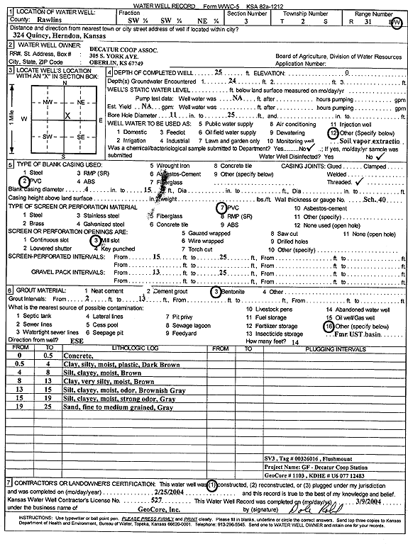
T2S, R31W, Sec. 3 SW SW NE |
Decatur Coop Assoc. | 25 ft. | Environmental Remediation, Soil Vapor Extraction | SV 3 | Plugged | 26-Jul-2006 | |||
|
T2S, R31W, Sec. 3 SE NE NW |
Decatur Coop Assoc. | 20.5 ft. | Monitoring well/observation/piezometer | MW 1 | Plugged | 25-Jul-2006 | |||
|
T2S, R31W, Sec. 3 SW SW NE |
Decatur Coop Assoc. | 25 ft. | Environmental Remediation, Soil Vapor Extraction | SV 3 | Constructed | 25-Feb-2004 | Scan | ||
|
T2S, R31W, Sec. 3 NE NW SE |
Decatur Coop Assoc. | 23.5 ft. | 19.5 ft. | Monitoring well/observation/piezometer | MW 6 | Plugged | 25-Jul-2006 | ||
|
T2S, R31W, Sec. 3 NE NW SE |
Decatur Coop Assoc. | 23 ft. | 21.5 ft. | Monitoring well/observation/piezometer | MW 2 | Plugged | 25-Jul-2006 | ||
|
T2S, R31W, Sec. 3 NE NW SE |
Decatur Coop Assoc. | 30.5 ft. | 20.5 ft. | Environmental Remediation, Air Sparge | AS 5 | Plugged | 25-Jul-2006 | ||
|
T2S, R31W, Sec. 3 NW NW SE |
Decatur Coop Assoc. | 29 ft. | 26 ft. | Monitoring well/observation/piezometer | MW 4 | Plugged | 26-Jul-2006 | ||
|
T2S, R31W, Sec. 3 SE NE NW |
Decatur Coop Assoc. | 31 ft. | 20.5 ft. | Environmental Remediation, Air Sparge | AS 1 | Plugged | 25-Jul-2006 | ||
|
T2S, R31W, Sec. 3 NE NW SE |
Decatur Coop Assoc. | 30 ft. | 20.5 ft. | Environmental Remediation, Air Sparge | AS 3 | Plugged | 25-Jul-2006 | ||
|
T2S, R31W, Sec. 3 SW SW NE |
Decatur Coop Assoc. | 26 ft. | 25.5 ft. | Monitoring well/observation/piezometer | MW 3 | Plugged | 26-Jul-2006 | ||
|
T2S, R31W, Sec. 3 NE NW SE |
Decatur Coop Assoc. | 30 ft. | 21 ft. | Environmental Remediation, Air Sparge | AS 2 | Plugged | 25-Jul-2006 | ||
|
T2S, R31W, Sec. 3 NE NW SE |
Decatur Coop Assoc. | 30 ft. | 21 ft. | Environmental Remediation, Air Sparge | AS 4 | Plugged | 25-Jul-2006 | ||
|
T2S, R31W, Sec. 3 NE NW SE |
Decatur Coop Assoc. | 23 ft. | 19.5 ft. | Monitoring well/observation/piezometer | MW 3 | Plugged | 25-Jul-2006 | ||
|
T2S, R31W, Sec. 3 SW SE SE NW |
Hafner, Robert | 36 ft. | 20 ft. | 20 gpm. | Domestic, Lawn and Garden | Constructed | 13-May-2014 |
KOLAR |
|
|
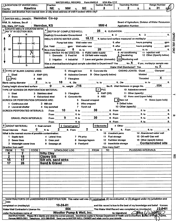
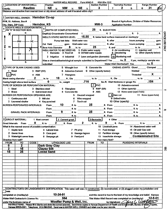
T2S, R31W, Sec. 3 NE NW SE |
Herndon Co-op | 25 ft. | 18.12 ft. | Monitoring well/observation/piezometer | MW 4 | Constructed | 24-Oct-2001 | Scan | |
|
T2S, R31W, Sec. 3 NE NW SE |
Herndon Co-op | 25 ft. | 16.23 ft. | Monitoring well/observation/piezometer | MW 5 | Constructed | 24-Oct-2001 | Scan | |
|
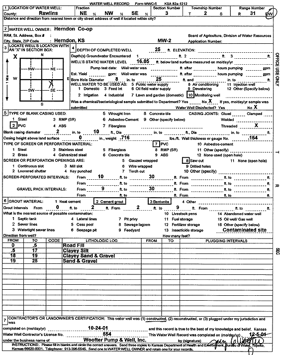
T2S, R31W, Sec. 3 NE NW SE |
Herndon Co-op | 25 ft. | 16.05 ft. | Monitoring well/observation/piezometer | MW 2 | Constructed | 24-Oct-2001 | Scan | |
|
T2S, R31W, Sec. 3 NE NW SE |
Herndon Co-op | 25 ft. | 15.55 ft. | Monitoring well/observation/piezometer | MW 3 | Constructed | 24-Oct-2001 | Scan | |
|
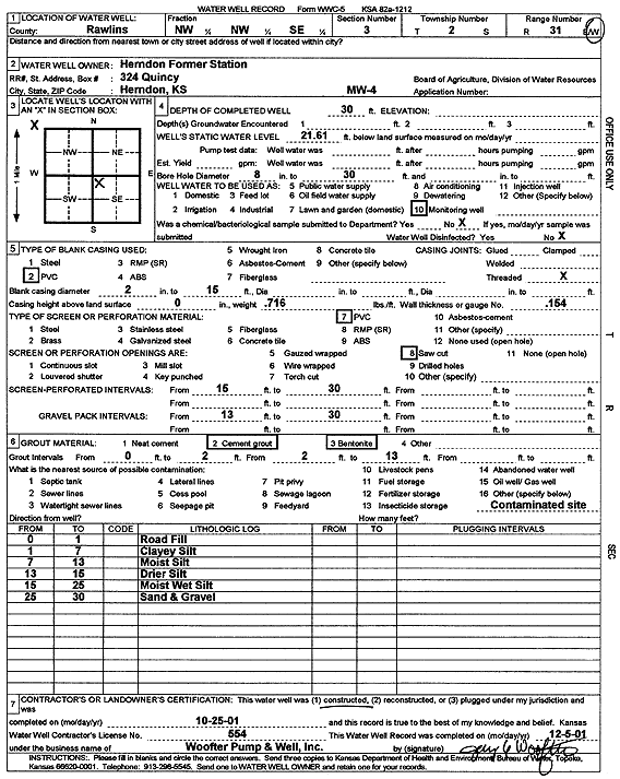
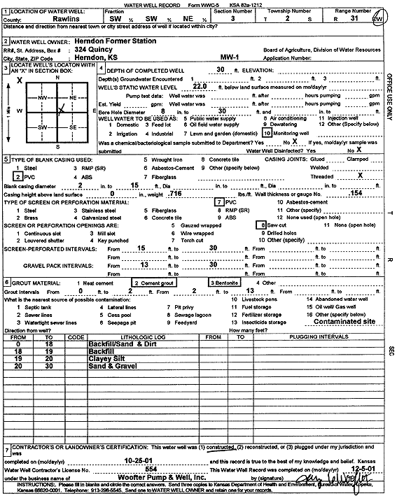
T2S, R31W, Sec. 3 NW NW SE |
Herndon Former Station | 30 ft. | 21.61 ft. | Monitoring well/observation/piezometer | MW 4 | Constructed | 25-Oct-2001 | Scan | |
|
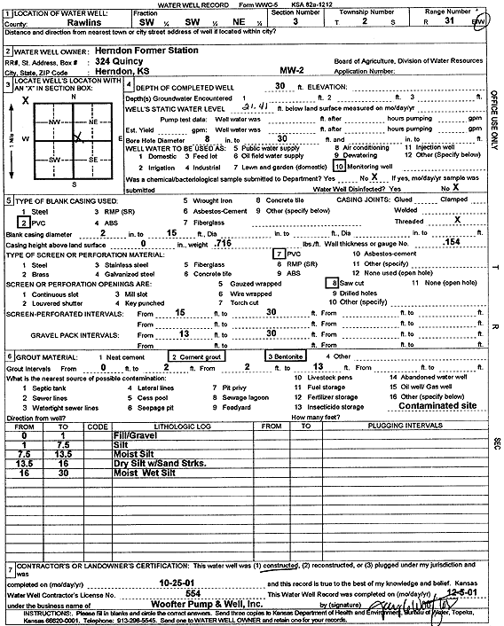
T2S, R31W, Sec. 3 SW SW NE |
Herndon Former Station | 30 ft. | 21.41 ft. | Monitoring well/observation/piezometer | MW 2 | Constructed | 25-Oct-2001 | Scan | |
|
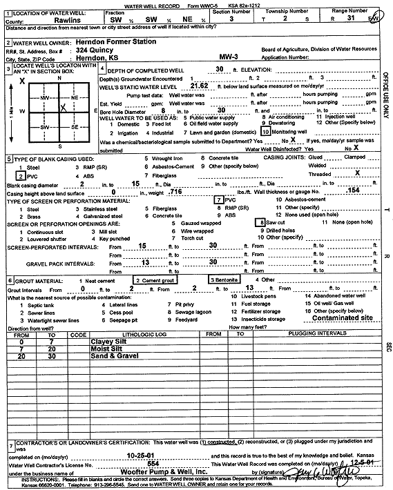
T2S, R31W, Sec. 3 SW SW NE |
Herndon Former Station | 30 ft. | 21.62 ft. | Monitoring well/observation/piezometer | MW 3 | Constructed | 25-Oct-2001 | Scan | |
|
T2S, R31W, Sec. 3 SW SW NE |
Herndon Former Station | 30 ft. | 22 ft. | Monitoring well/observation/piezometer | MW 1 | Constructed | 25-Oct-2001 | Scan | |
|
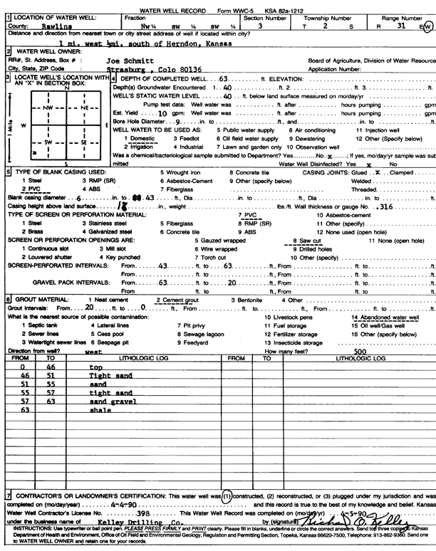
T2S, R31W, Sec. 3 NW SW SW |
Schmitt, Joe | 63 ft. | 40 ft. | 10 gpm. | Domestic | Constructed | 04-Apr-1990 | Scan | |
|
T2S, R31W, Sec. 3 NW SE SE NW |
Solko, Alan | 43 ft. | 20 ft. | 20 gpm. | Domestic, Lawn and Garden | Constructed | 13-May-2014 |
KOLAR |
|
|
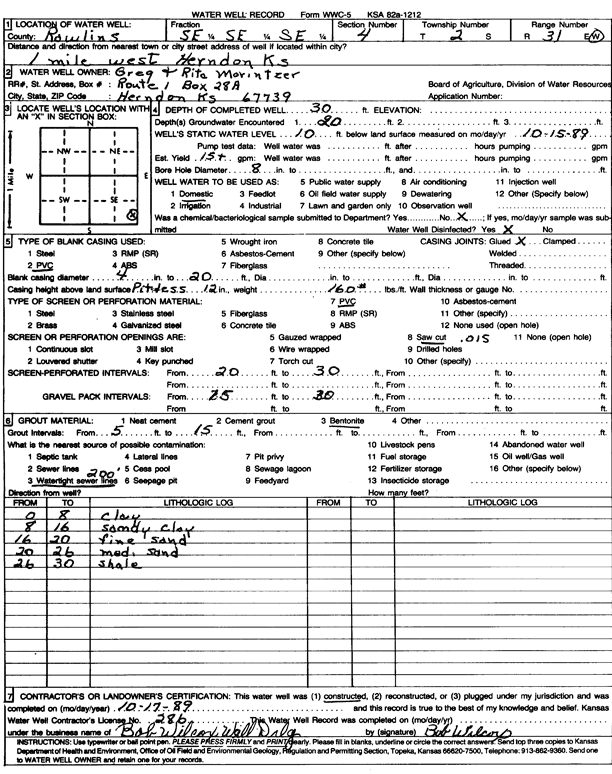
T2S, R31W, Sec. 4 SE SE SE |
Morintzer, Greg and Rita | 30 ft. | 10 ft. | 15 gpm. | Domestic | Constructed | 17-Oct-1989 | Scan | |
|
T2S, R31W, Sec. 4 SE NW SW SE |
Murfin Drilling Co. | 36 ft. | 15 ft. | 40 gpm. | Oil Field Water Supply | Marintzer 1-4 | Constructed | 21-Mar-2019 |
KOLAR |
|
T2S, R31W, Sec. 4 SE NW SW SE |
Murfin Drilling Co. | 36 ft. | 15 ft. | Oil Field Water Supply | Marintzer 1-4 | Plugged | 14-Jun-2019 |
KOLAR |
|
|
T2S, R31W, Sec. 5 SW SW SW |
Basgall, Tom | 37 ft. | 24 ft. | 10 gpm. | Domestic | Constructed | 21-Apr-2005 | ||
|
T2S, R31W, Sec. 5 SE SE SE |
Hanson, Brian | 40 ft. | 22 ft. | 10 gpm. | Domestic | Constructed | 12-Nov-2010 | ||
|
T2S, R31W, Sec. 5 NE |
Niemeth, Gerald | 25 ft. | 9 ft. | Domestic, Livestock | Plugged | 25-Jul-2016 | |||
|
T2S, R31W, Sec. 5 NW SE NE NE |
Niemeth, Jerry | 32 ft. | 14 ft. | 10 gpm. | Domestic | Constructed | 21-Jul-2016 | ||
|
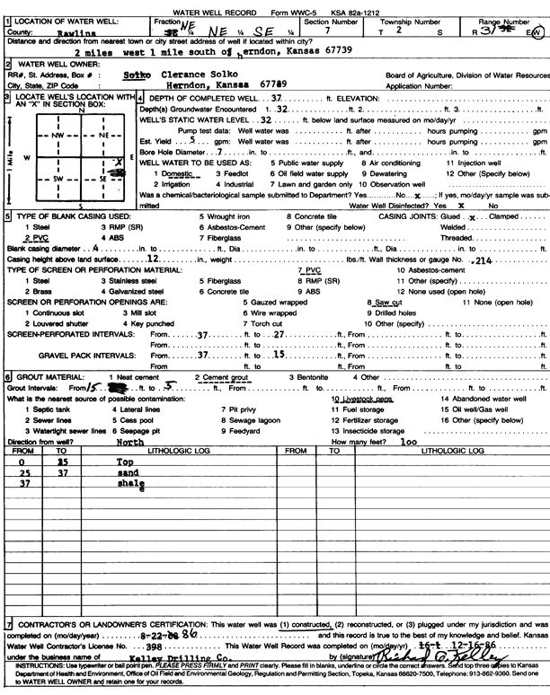
T2S, R31W, Sec. 7 NE NE SE |
Solko, Clarence | 37 ft. | 32 ft. | 5 gpm. | Domestic | Constructed | 22-Aug-1986 | Scan | |
|
T2S, R31W, Sec. 7 NE NE SE |
Solko, Monica | 42 ft. | 32 ft. | Domestic | Constructed | 15-Aug-2003 | Scan | ||
|
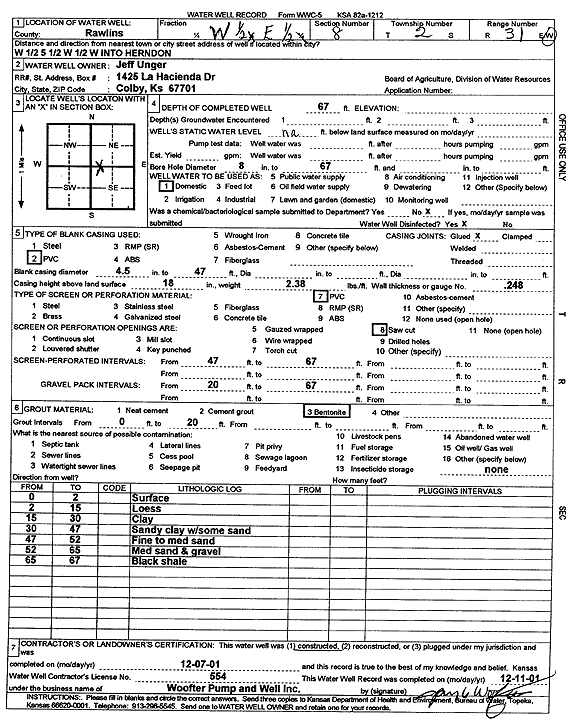
T2S, R31W, Sec. 8 W2 E2 |
Unger, Jeff | 67 ft. | Domestic | Constructed | 07-Dec-2001 | Scan | |||
|
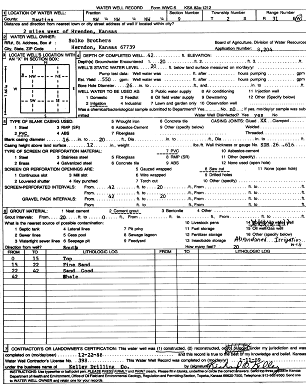
T2S, R31W, Sec. 9 SW NW NW |
Solko Brothers | 42 ft. | 20 ft. | 550 gpm. | Irrigation | Constructed | 22-Dec-1988 | Scan | |
|
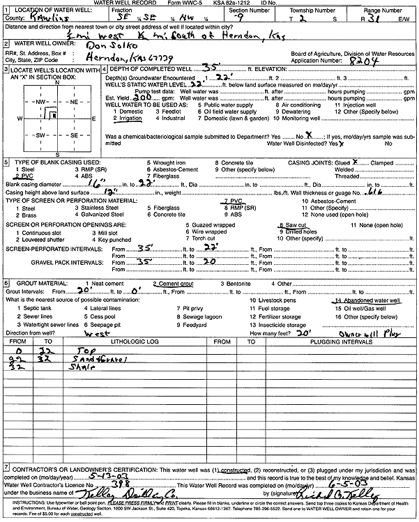
T2S, R31W, Sec. 9 SE SE NW |
Solko, Don | 35 ft. | 22 ft. | 200 gpm. | Irrigation | Constructed | 13-May-2003 | Scan | |
|
T2S, R31W, Sec. 10 SE SE NE |
Fisher, Kendell | 90 ft. | 75 ft. | Domestic, Livestock | Constructed | 28-May-2026 |
KOLAR |
||
| View page: 1 || 2 || 3 || 4 || 5 || 6 || 7 || 8 || 9 || 10 || Next > | |||||||||