Select location of well to view details.
Click on column heading to sort.
|
|
|
County: Rawlins Select location of well to view details. Click on column heading to sort. |
|
|
|
| View page: 1 || 2 || 3 || 4 || 5 || 6 || 7 || 8 || 9 || 10 || Next > | |||||||||
| T-R-S | Owner | Well Depth Ascend. Desc. |
Static Water Level Ascend. Desc. |
Est. Yield Ascend. Desc. |
Well Use | Other ID | Action Taken | Completion Date Ascend. Desc. |
Scan? |
|
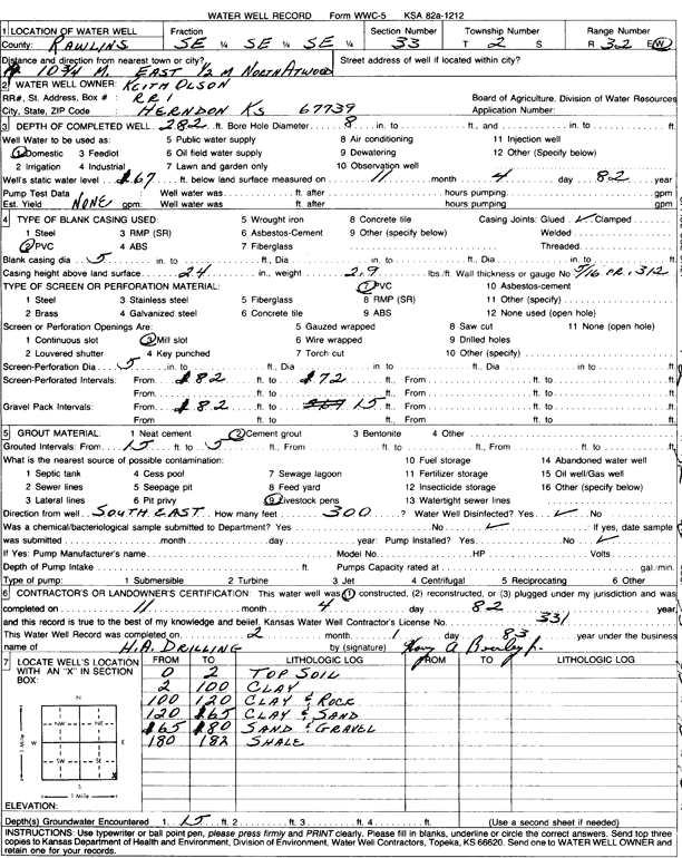
T2S, R32W, Sec. 33 SE SE SE |
Olson, Keith | 282 ft. | 167 ft. | Domestic | Constructed | 04-Nov-1982 | Scan | ||
|
T2S, R32W, Sec. 36 NW SE SE |
Anderson, Roland | 139 ft. | 133 ft. | 8 gpm. | Domestic | Constructed | 11-Oct-1988 | Scan | |
|
T2S, R33W, Sec. 2 NW NW NE |
Renunitz, Gordon | 211 ft. | 170 ft. | Domestic, Livestock | Constructed | 15-Apr-2011 | |||
|
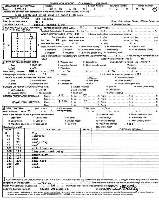
T2S, R33W, Sec. 3 SW NE NE |
Wolters, Tim | 210 ft. | 197 ft. | 10 gpm. | Domestic | Constructed | 15-Oct-1996 | Scan | |
|
T2S, R33W, Sec. 4 W2 SE SE NE |
Brubaker, Jane | 180 ft. | 30 ft. | Other | Plugged | 25-Oct-2021 | |||
|
T2S, R33W, Sec. 5 NE NE NE NW |
Horineck, Berny | 38 ft. | 12 ft. | 10 gpm. | Domestic, Livestock | Constructed | 01-Oct-2016 | ||
|
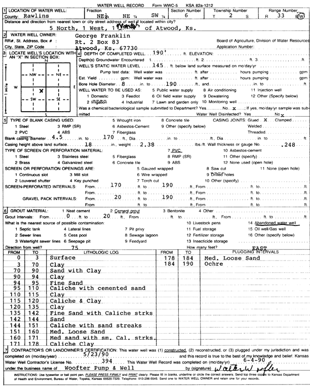
T2S, R33W, Sec. 6 NE NE SW |
Franklin, George | 190 ft. | 185 ft. | Domestic | Constructed | 23-May-1990 | Scan | ||
|
T2S, R33W, Sec. 9 NW NW NW |
Bearley, Craig and Valerie | 217 ft. | 188 ft. | Domestic | Constructed | 26-Jun-2006 | |||
|
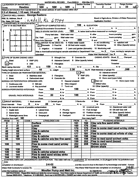
T2S, R33W, Sec. 9 NW NW NW |
Kastens, George | 198 ft. | 169 ft. | Domestic | Constructed | 06-Feb-2002 | Scan | ||
|
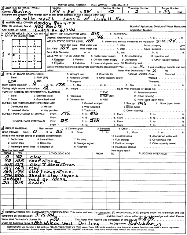
T2S, R33W, Sec. 12 NW NW SW |
Reunitz, Gordon | 215 ft. | 169 ft. | 10 gpm. | Domestic | Constructed | 15-Mar-1994 | Scan | |
|
T2S, R33W, Sec. 13 NE NE SW SE |
Laufer, Brian | 98 ft. | 80 ft. | 10 gpm. | Domestic | Constructed | 07-Sep-2011 | ||
|
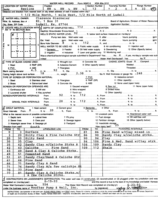
T2S, R33W, Sec. 13 NW NW NW |
Niermeier, Clarence | 112 ft. | 92 ft. | Domestic | Constructed | 19-Jun-1993 | Scan | ||
|
T2S, R33W, Sec. 13 SW SW SW |
Pianalto, Margaret | 60 ft. | 39 ft. | Domestic | Constructed | 30-Jun-2008 | |||
|
T2S, R33W, Sec. 14 NE NE NE |
Niermeier, Clarence | 112 ft. | 86 ft. | Domestic | Constructed | 16-Dec-2005 | |||
|
T2S, R33W, Sec. 17 SW SW SE |
Kastens, Terry | 210 ft. | Domestic | Constructed | 30-Apr-2012 | ||||
|
T2S, R33W, Sec. 17 NE SE SW SW |
Section 17 LLC | 215 ft. | 180 ft. | 25 gpm. | Domestic | Constructed | 10-Aug-2021 |
KOLAR |
|
|
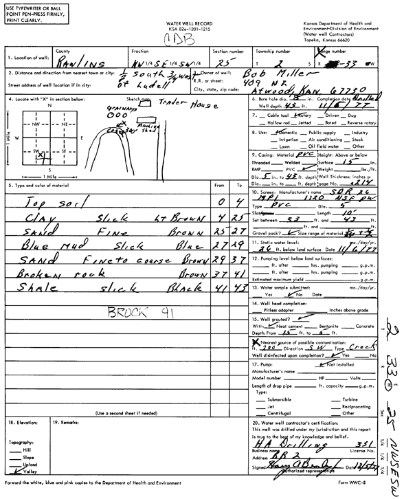
T2S, R33W, Sec. 25 NW SE SW |
Miller, Bob | 43 ft. | 26 ft. | Domestic | Constructed | 06-Nov-1977 | Scan | ||
|
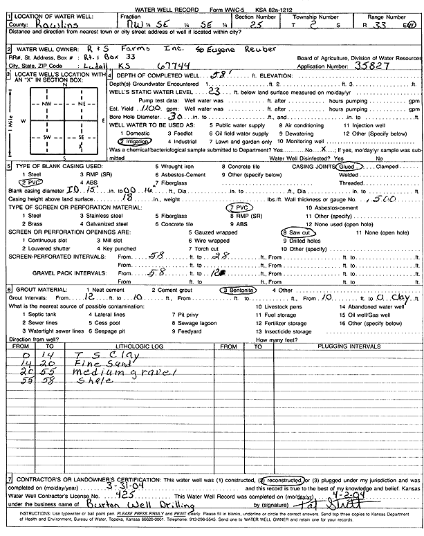
T2S, R33W, Sec. 25 NW SE SE |
R and S Farms, Inc. | 58 ft. | 23 ft. | 1100 gpm. | Irrigation | Reconstructed | 31-Mar-2004 | Scan | |
|
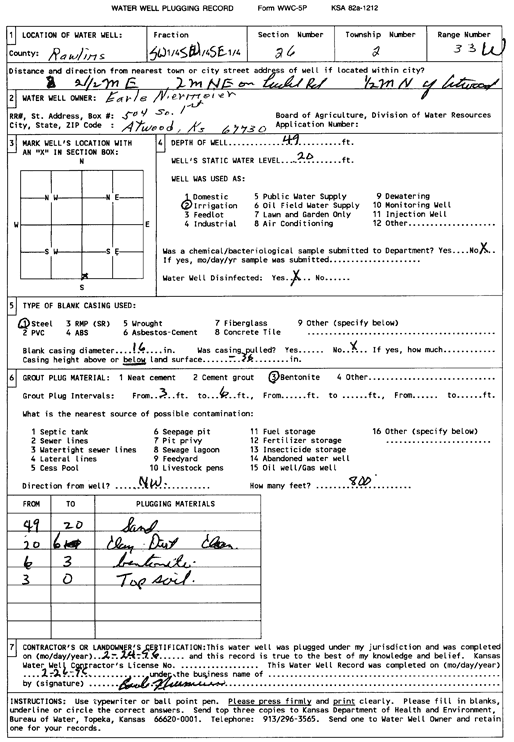
T2S, R33W, Sec. 26 SW SW SE |
Niermeier, Earle | 49 ft. | 20 ft. | Irrigation | Plugged | 24-Feb-1996 | Scan | ||
|
T2S, R33W, Sec. 31 NE SE SE |
Horinek, David | 80 ft. | Domestic | Constructed | 29-Oct-2004 | ||||
|
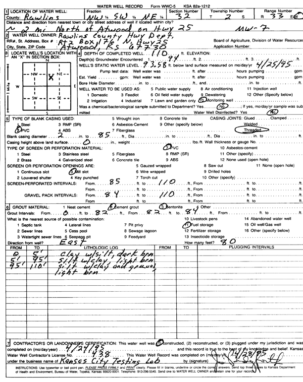
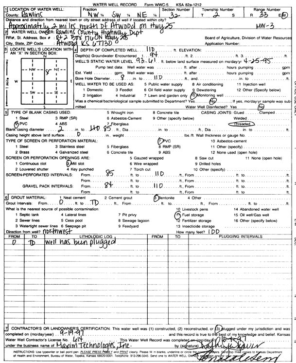
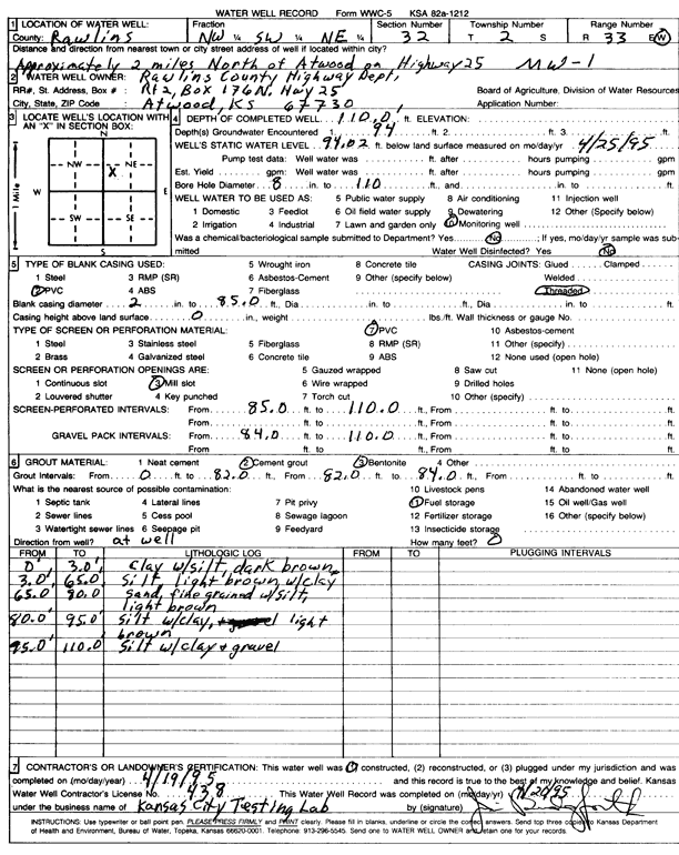
T2S, R33W, Sec. 32 NW SW NE |
Rawlins County Highway Dept. | 110 ft. | 93.58 ft. | Monitoring well/observation/piezometer | MW 7 | Plugged | 19-Sep-1997 | Scan | |
|
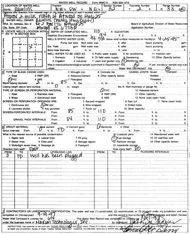
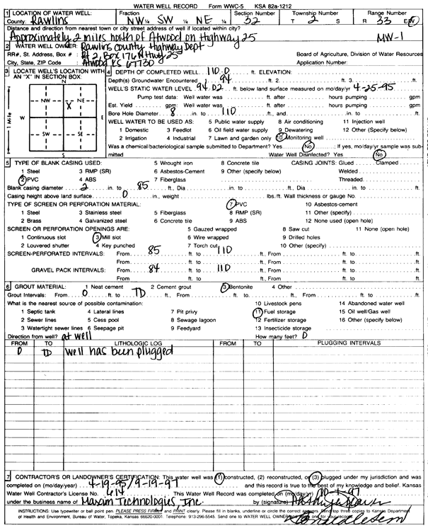
T2S, R33W, Sec. 32 NW SW NE |
Rawlins County Highway Dept. | 110 ft. | 94.62 ft. | Monitoring well/observation/piezometer | MW 5 | Plugged | 19-Sep-1997 | Scan | |
|
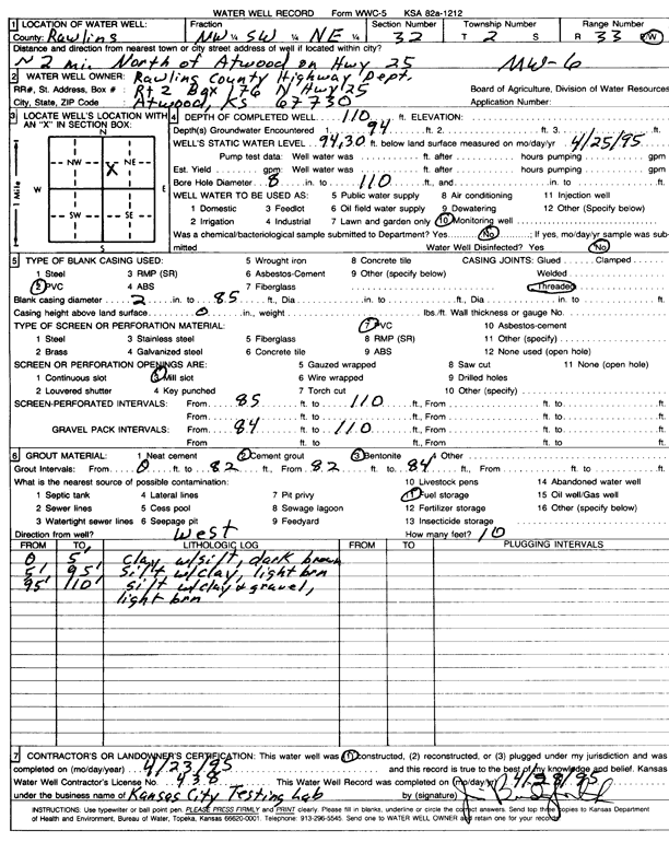
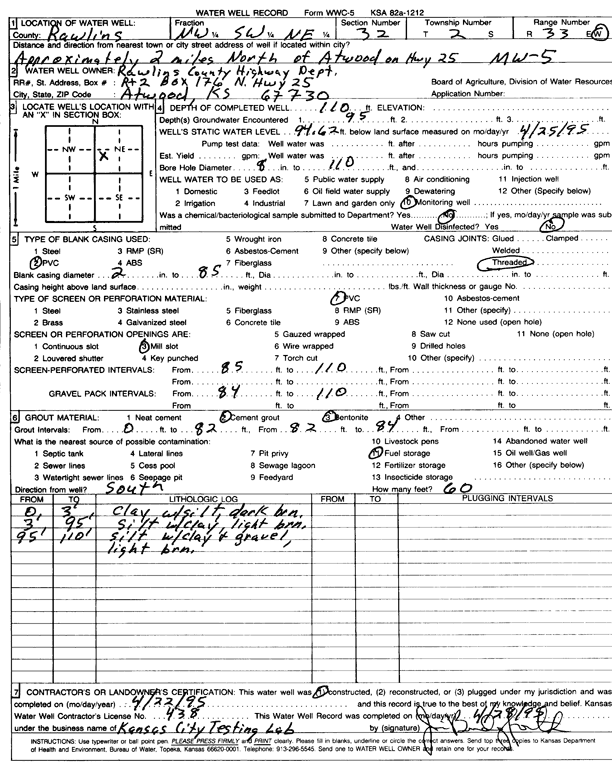
T2S, R33W, Sec. 32 NW SW NE |
Rawlins County Highway Dept. | 110 ft. | 94.3 ft. | Monitoring well/observation/piezometer | MW 6 | Constructed | 23-Apr-1995 | Scan | |
|
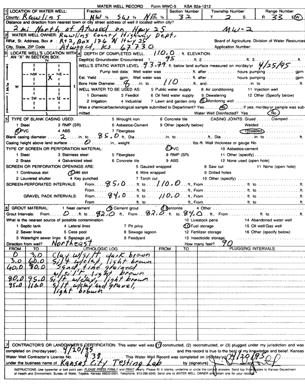
T2S, R33W, Sec. 32 NW SW NE |
Rawlins County Highway Dept. | 110 ft. | 93.79 ft. | Monitoring well/observation/piezometer | MW 2 | Constructed | 20-Apr-1995 | Scan | |
|
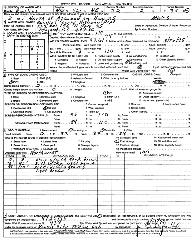
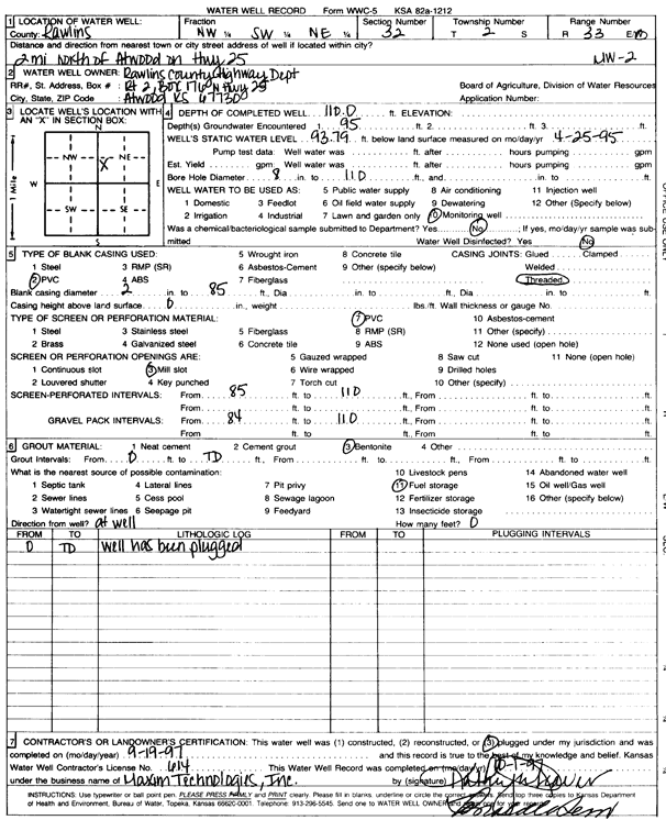
T2S, R33W, Sec. 32 NW SW NE |
Rawlins County Highway Dept. | 110 ft. | 93.61 ft. | Monitoring well/observation/piezometer | MW 3 | Constructed | 20-Apr-1995 | Scan | |
|
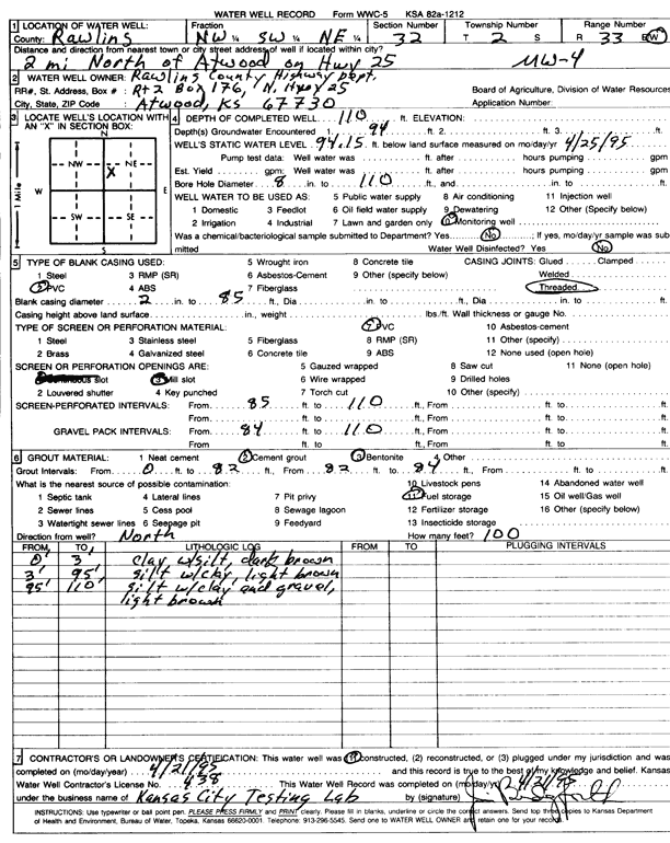
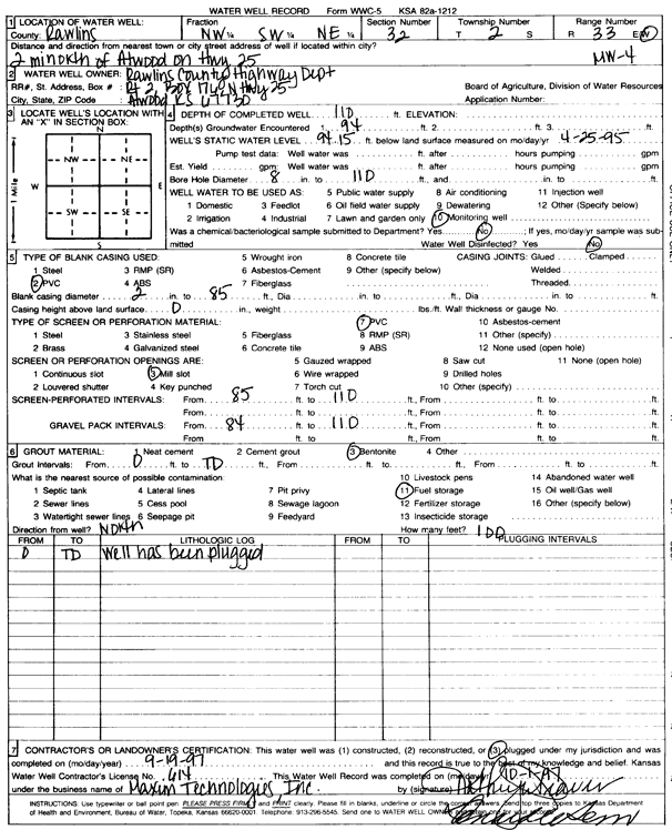
T2S, R33W, Sec. 32 NW SW NE |
Rawlins County Highway Dept. | 110 ft. | 94.15 ft. | Monitoring well/observation/piezometer | MW 4 | Constructed | 21-Apr-1995 | Scan | |
|
T2S, R33W, Sec. 32 NW SW NE |
Rawlins County Highway Dept. | 110 ft. | 93.58 ft. | Monitoring well/observation/piezometer | MW 7 | Constructed | 24-Apr-1995 | Scan | |
|
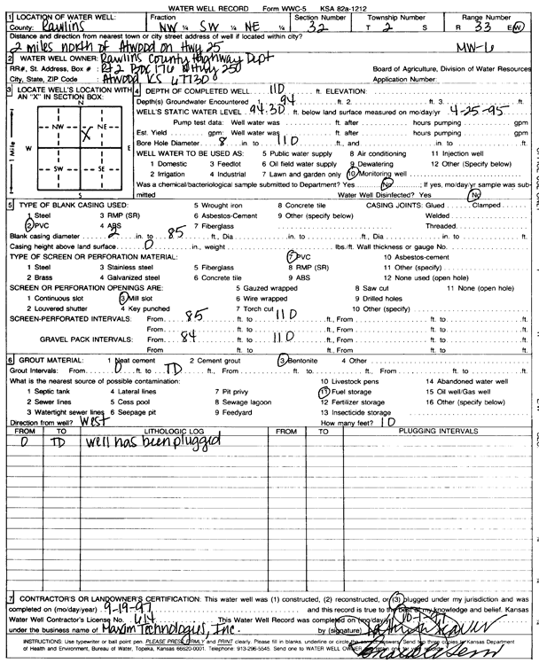
T2S, R33W, Sec. 32 NW SW NE |
Rawlins County Highway Dept. | 110 ft. | 94.3 ft. | Monitoring well/observation/piezometer | MW 6 | Plugged | 19-Sep-1997 | Scan | |
|
T2S, R33W, Sec. 32 NW SW NE |
Rawlins County Highway Dept. | 110 ft. | 94.15 ft. | Monitoring well/observation/piezometer | MW 4 | Plugged | 19-Sep-1997 | Scan | |
|
T2S, R33W, Sec. 32 NW SW NE |
Rawlins County Highway Dept. | 110 ft. | 94.02 ft. | Monitoring well/observation/piezometer | MW 1 | Plugged | 19-Sep-1997 | Scan | |
|
T2S, R33W, Sec. 32 NW SW NE |
Rawlins County Highway Dept. | 110 ft. | 94.62 ft. | Monitoring well/observation/piezometer | MW 5 | Constructed | 22-Apr-1995 | Scan | |
|
T2S, R33W, Sec. 32 NW SW NE |
Rawlins County Highway Dept. | 110 ft. | 93.79 ft. | Monitoring well/observation/piezometer | MW 2 | Plugged | 19-Sep-1997 | Scan | |
|
T2S, R33W, Sec. 32 NW SW NE |
Rawlins County Highway Dept. | 110 ft. | 93.61 ft. | Monitoring well/observation/piezometer | MW 3 | Plugged | 19-Sep-1997 | Scan | |
|
T2S, R33W, Sec. 32 NW SW NE |
Rawlins County Highway Dept. | 110 ft. | 94.02 ft. | Monitoring well/observation/piezometer | MW 1 | Constructed | 19-Apr-1995 | Scan | |
|
T2S, R33W, Sec. 33 NW SW SW SW |
Ruda, Tom | 105 ft. | 92 ft. | Domestic | Plugged | 17-Aug-2018 |
KOLAR |
||
|
T2S, R33W, Sec. 33 NW SW SW SW |
Ruda, Tom | 105 ft. | 92 ft. | 10 gpm. | Domestic | Constructed | 07-Aug-2018 |
KOLAR |
|
|
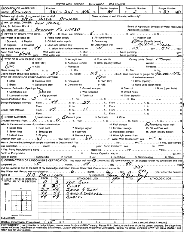
T2S, R33W, Sec. 34 SW SW NE |
Heble, Don | 49 ft. | 44 ft. | Domestic, Livestock | Constructed | 15-May-1980 | Scan | ||
|
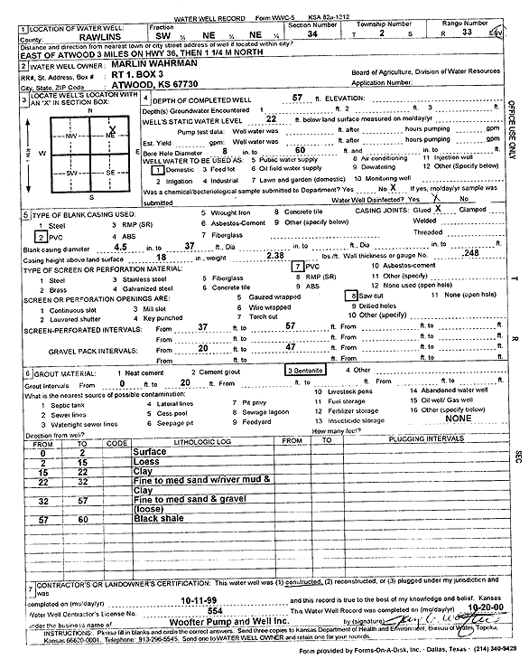
T2S, R33W, Sec. 34 SW NE NE |
Wahrman, Marilin | 57 ft. | 22 ft. | Domestic | Constructed | 11-Oct-1999 | Scan | ||
|
T2S, R33W, Sec. 34 NE SW NW |
Wolters, Matt | 83 ft. | 45 ft. | 15 gpm. | Domestic | Constructed | 20-Mar-2023 |
KOLAR |
|
|
T2S, R33W, Sec. 34 SW NW NW |
Wolters, Matt | 120 ft. | Domestic | Constructed | 30-Dec-2022 |
KOLAR |
|||
|
T2S, R33W, Sec. 34 SE NW NW |
Wolters, Matt | 80 ft. | 40 ft. | 15 gpm. | Domestic | Constructed | 24-Oct-2022 |
KOLAR |
|
|
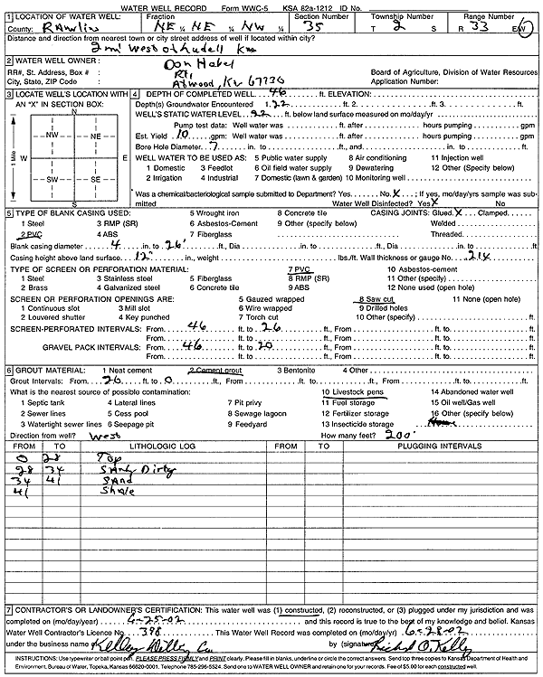
T2S, R33W, Sec. 35 NE NE NW |
Hebel, Don | 46 ft. | 22 ft. | 10 gpm. | (unstated)/abandoned | Constructed | 25-Apr-2002 | Scan | |
|
T2S, R33W, Sec. 35 SW SW SW |
Wahrman, Marlin | 43 ft. | 28 ft. | 10 gpm. | Domestic | Constructed | 16-Aug-2006 | ||
|
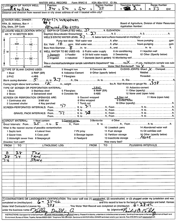
T2S, R33W, Sec. 35 SW SW SW |
Wahrman, Marlin | 37 ft. | 27 ft. | 10 gpm. | Domestic | Constructed | 25-Jun-2002 | Scan | |
|
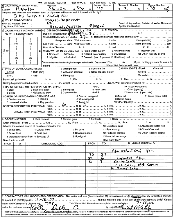
T2S, R33W, Sec. 35 SW SW SW |
Wahrman, Marlin | 30 ft. | 27 ft. | (unstated)/abandoned | Plugged | 10-Jul-2002 | Scan | ||
|
T2S, R33W, Sec. 35 S2 |
Wurm, Auldred | 55 ft. | Domestic | Constructed | 06-Jun-2006 | ||||
|
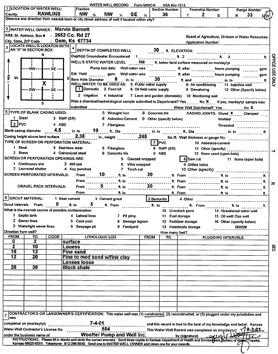
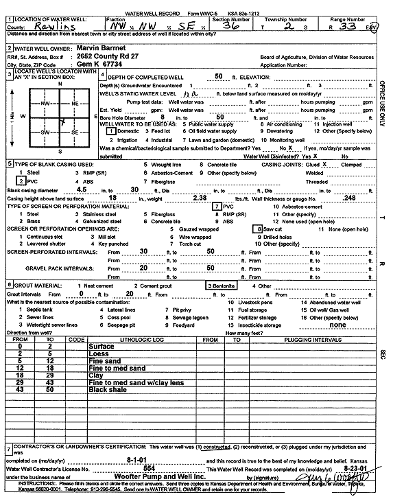
T2S, R33W, Sec. 36 NW NW SE |
Barnett, Marvin | 30 ft. | Domestic | Constructed | 04-Jul-2001 | Scan | |||
|
T2S, R33W, Sec. 36 NW NW SE |
Barnett, Marvin | 50 ft. | Domestic | Constructed | 01-Aug-2001 | Scan | |||
|
T2S, R34W, Sec. 2 NE NE NE NE |
Dozababa, Richard | 100 ft. | 40 ft. | 10 gpm. | Domestic, Livestock | Constructed | 08-Aug-2016 |
KOLAR |
|
|
T2S, R34W, Sec. 7 NE SW SW SW |
Haller, Glenn | 165 ft. | 145 ft. | 50 gpm. | Oil Field Water Supply | Haller 1-7 | Constructed | 11-Nov-2016 |
KOLAR |
| View page: 1 || 2 || 3 || 4 || 5 || 6 || 7 || 8 || 9 || 10 || Next > | |||||||||