Select location of well to view details.
Click on column heading to sort.
|
|
|
County: Rawlins Select location of well to view details. Click on column heading to sort. |
|
|
|
| View page: 1 || 2 || 3 || 4 || 5 || 6 || 7 || 8 || 9 || 10 || Next > | |||||||||
| T-R-S | Owner | Well Depth Ascend. Desc. |
Static Water Level Ascend. Desc. |
Est. Yield Ascend. Desc. |
Well Use | Other ID | Action Taken | Completion Date Ascend. Desc. |
Scan? |
|
T2S, R35W, Sec. 32 SE NE SE NE |
City of Atwood | 252 ft. | 126 ft. | 200 gpm. | Public Water Supply | Constructed | 20-Jan-2011 | ||
|
T2S, R35W, Sec. 32 NE NE NE SE |
City of Atwood | 245 ft. | 122 ft. | Test hole/well | test well | Plugged | 11-Nov-2010 | ||
|
T2S, R35W, Sec. 32 NW NE NE SE |
City of Atwood | 252 ft. | 124 ft. | Irrigation | Plugged | 11-Nov-2010 | |||
|
T2S, R35W, Sec. 32 NE NE NE SE |
City of Atwood | 248 ft. | Test hole/well | Constructed | 29-Sep-2009 | ||||
|
T2S, R35W, Sec. 32 NE NW SW SW |
Deutsch Oil Co. | 215 ft. | 170 ft. | 75 gpm. | Oil Field Water Supply | VRP 1-32 | Constructed | 08-Jan-2018 |
KOLAR |
|
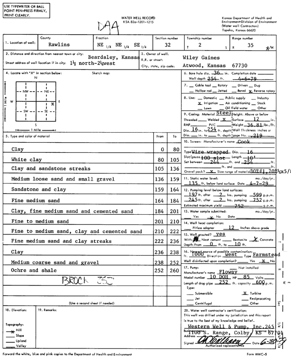
T2S, R35W, Sec. 32 NE NE SE |
Gaines, Wiley | 254 ft. | 135 ft. | 752 gpm. | Irrigation | Constructed | 06-Apr-1979 | Scan | |
|
T2S, R35W, Sec. 33 NW NW NW SW |
City of Atwood | 270 ft. | 125.5 ft. | 300 gpm. | Public Water Supply | well 6 | Constructed | 08-Sep-2010 | |
|
T2S, R35W, Sec. 33 SE SW NE SE |
Pochop, Victor | 140 ft. | 40 ft. | 17 gpm. | Domestic, Livestock | Constructed | 15-Nov-2016 |
KOLAR |
|
|
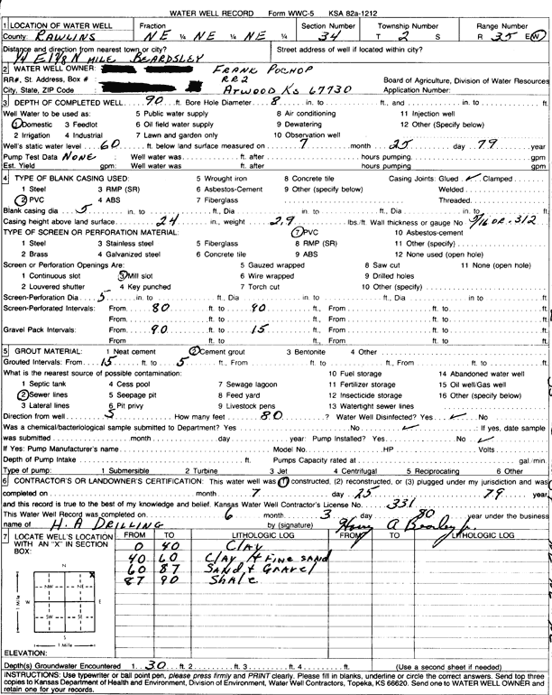
T2S, R35W, Sec. 34 NE NE NE |
Pochop, Frank | 90 ft. | 60 ft. | Domestic | Constructed | 25-Jul-1979 | Scan | ||
|
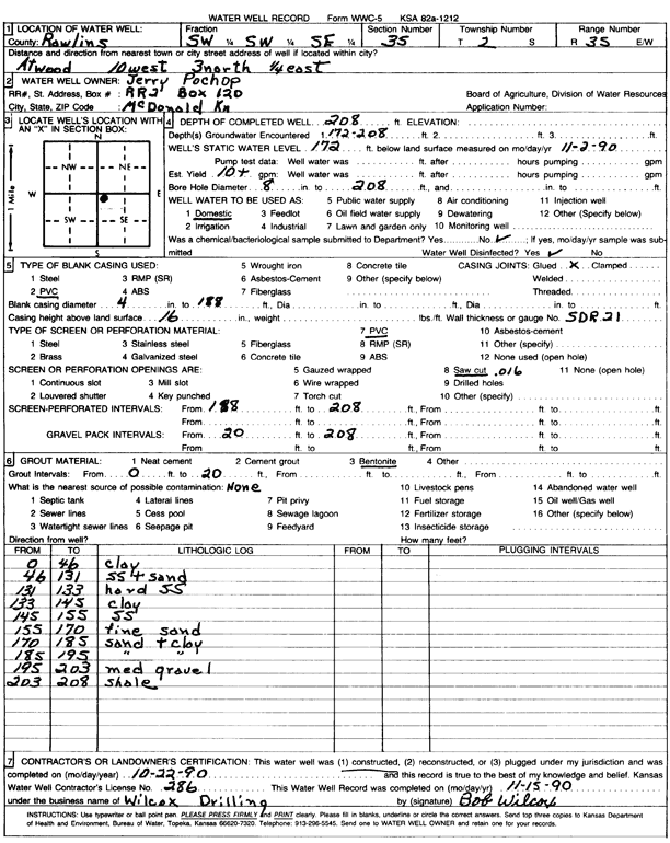
T2S, R35W, Sec. 35 NW SW SW |
Pochop, Gerard | 208 ft. | 172 ft. | 10 gpm. | Domestic | Constructed | 28-Nov-1990 | Scan | |
|
T2S, R35W, Sec. 35 SW SW SE |
Pochop, Jerry | 208 ft. | 172 ft. | 10 gpm. | Domestic | Constructed | 22-Oct-1990 | Scan | |
|
T2S, R35W, Sec. 35 NW SE NW NE |
Pochop, Kevin (was Murfin Drilling) | 125 ft. | 100 ft. | 10 gpm. | Oil Field Water Supply | Pochop B 1 35 | Constructed | 14-Feb-2017 |
KOLAR |
|
T2S, R35W, Sec. 35 SW SW NE SW |
Zeigler, James | 205 ft. | 155 ft. | 30 gpm. | Domestic, Livestock | Constructed | 01-Aug-2013 |
KOLAR |
|
|
T2S, R35W, Sec. 36 SE SW NE |
Vapp, J. E. | 200 ft. | 149 ft. | 15 gpm. | Domestic, Livestock | Constructed | 21-Dec-2023 |
KOLAR |
|
|
T2S, R36W, Sec. 2 NW SE SW NW |
Wilkinson, Bradley | 235 ft. | 197 ft. | Oil Field Water Supply | Wilkinson Trust 'KP' 1-2 | Plugged | 03-Nov-2014 |
KOLAR |
|
|
T2S, R36W, Sec. 2 NW SE SW NW |
Wilkinson, Bradley | 235 ft. | 198 ft. | 30 gpm. | Oil Field Water Supply | Wilkinson Trust 'KP' 1-2 | Constructed | 03-Nov-2014 |
KOLAR |
|
T2S, R36W, Sec. 3 NE NE NE NE |
Wilkinson, Greg | 232 ft. | Domestic | Constructed | 17-Jul-2012 | ||||
|
T2S, R36W, Sec. 4 SW SE SW |
Cahoj, Victor | 257 ft. | 160 ft. | Domestic | Constructed | 24-Sep-1992 | |||
|
T2S, R36W, Sec. 5 NE SW SW NW |
Sabatka, Linda (was Murfin Drilling Co.) | 135 ft. | 87 ft. | 50 gpm. | Domestic, changed from Oil Field Water Supply | Kacirek Trust 1-5 | Constructed | 01-Jan-2014 |
KOLAR |
|
T2S, R36W, Sec. 6 SE NW NW SE |
Frisbie, Richard (was Murfin Drilling Co.) | 210 ft. | 160 ft. | 40 gpm. | Domestic, changed from Oil Field Water Supply | Frisbie 'A' | Constructed | 11-May-2015 |
KOLAR |
|
T2S, R36W, Sec. 7 NE SW SW SE |
Panter, Richard | 250 ft. | 180 ft. | 45 gpm. | Oil Field Water Supply | Pancirni 1-7 | Constructed | 25-Nov-2014 |
KOLAR |
|
T2S, R36W, Sec. 7 SW NW NW SW |
Panter, Richard (Was Murfin Drilling Co.) | 280 ft. | 220 ft. | 88 gpm. | Oil Field Water Supply | Pancirni 3-7 | Constructed | 31-Jul-2017 |
KOLAR |
|
T2S, R36W, Sec. 7 NE SW SW SE |
Panther, Richard | 250 ft. | 222 ft. | Oil Field Water Supply | Pancirni 1-7 | Plugged | 08-Dec-2014 |
KOLAR |
|
|
T2S, R36W, Sec. 8 SE SE SE |
Sabatka, R.J. and Susie | 295 ft. | 208 ft. | 15 gpm. | Domestic | Constructed | 11-Mar-2025 |
KOLAR |
|
|
T2S, R36W, Sec. 8 SE SE SE |
Sabatka, Susie | 200 ft. | Domestic | Plugged | 08-Jan-2011 | ||||
|
T2S, R36W, Sec. 11 SW NW NW |
Sramek, Mike | 267 ft. | 196 ft. | 550 gpm. | Irrigation | Constructed | 01-Aug-1975 | Scan | |
|
T2S, R36W, Sec. 13 NW SW NW NW |
Frisbie, David | 280 ft. | 189 ft. | 400 gpm. | Irrigation | Constructed | 25-Jan-2012 | ||
|
T2S, R36W, Sec. 13 NW NW NW NW |
Frisbie, David | 275 ft. | 189 ft. | 400 gpm. | Irrigation | Constructed | 19-Jan-2012 | ||
|
T2S, R36W, Sec. 13 C NE SW |
Jerry Frisbie/Mark Torr | 278 ft. | 165 ft. | Oil Field Water Supply | Constructed | 26-Dec-1992 | Scan | ||
|
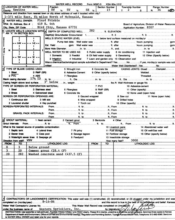
T2S, R36W, Sec. 15 SW SW SE |
Frisbie, Floyd | 282 ft. | Irrigation | Plugged | 14-Aug-1986 | Scan | |||
|
T2S, R36W, Sec. 16 NE NE SW NW |
Wilkenson, Greg | 280 ft. | 180 ft. | 75 gpm. | Oil Field Water Supply | Wilkenson Trust 1-16 | Constructed | 15-Jan-2014 |
KOLAR |
|
T2S, R36W, Sec. 16 NE NE SW NW |
Wilkenson, Greg | 280 ft. | 180 ft. | Oil Field Water Supply | Wilkenson Trust 1-16 | Plugged | 06-Jul-2015 |
KOLAR |
|
|
T2S, R36W, Sec. 21 NW SE NW NE |
Kacirek, Kit | 300 ft. | 165 ft. | 60 gpm. | Oil Field Water Supply | Kacirek 1-21 | Constructed | 10-Sep-2012 |
KOLAR |
|
T2S, R36W, Sec. 21 NW SE NW NE |
Kacirek, Kit | 300 ft. | 165 ft. | 60 gpm. | Oil Field Water Supply | Kacirek 1-21 | Plugged | 14-Feb-2013 |
KOLAR |
|
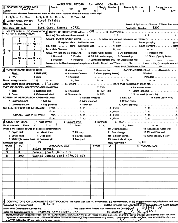
T2S, R36W, Sec. 22 NW SW NE |
Frisbie, Floyd | 290 ft. | Irrigation | Plugged | 14-Aug-1986 | Scan | |||
|
T2S, R36W, Sec. 22 SE SW NW SE |
PTL Farms Inc | 293 ft. | 180 ft. | 75 gpm. | Oil Field Water Supply | PTL 1-22 | Plugged | 04-Mar-2013 |
KOLAR |
|
T2S, R36W, Sec. 22 SE SW NW SE |
PTL Farms Inc | 293 ft. | 180 ft. | 75 gpm. | Oil Field Water Supply | PTL 1-22 | Constructed | 15-Oct-2012 |
KOLAR |
|
T2S, R36W, Sec. 23 NE SE SE NW |
Frisbie, Dave (was Murfin Drilling Co.) | 260 ft. | 210 ft. | 55 gpm. | Domestic, changed from Oil Field Water Supply | Frisbie 1-23 | Constructed | 15-Nov-2012 |
KOLAR |
|
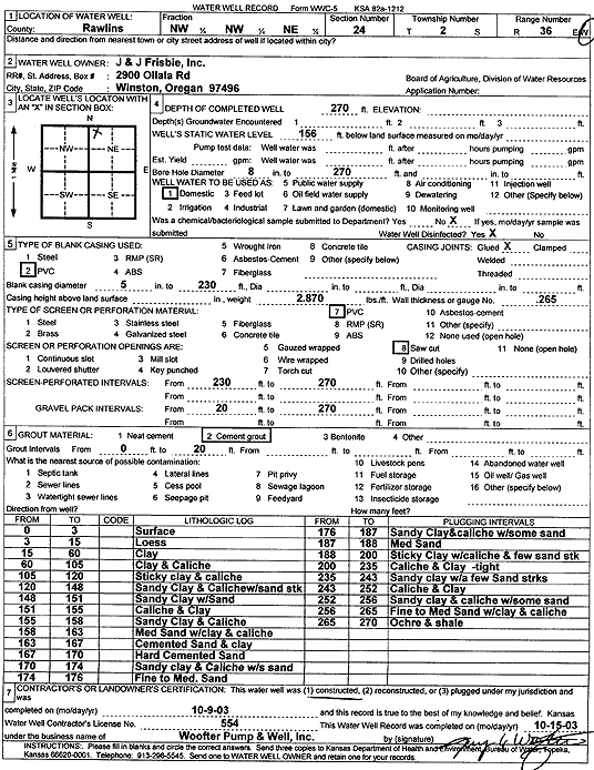
T2S, R36W, Sec. 24 NW NW NE |
J and J Frisbie, Inc. | 270 ft. | 156 ft. | Domestic | Constructed | 09-Oct-2003 | Scan | ||
|
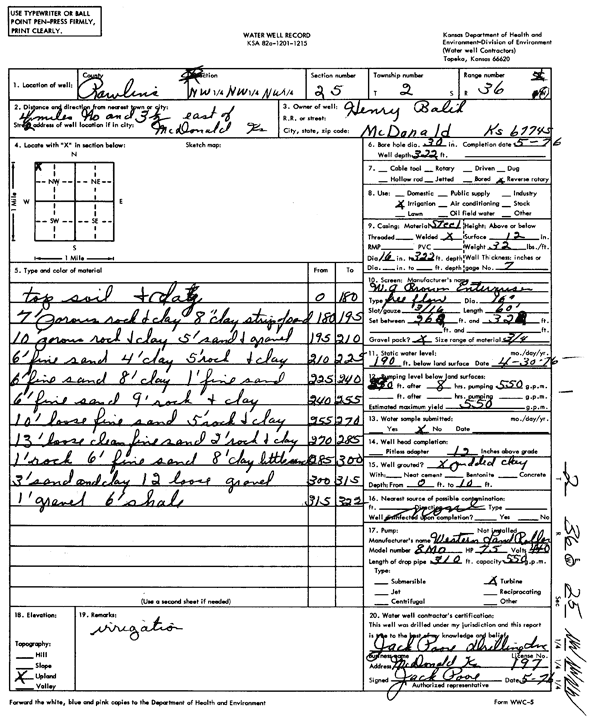
T2S, R36W, Sec. 25 NW NW NW |
Balik, Henry | 322 ft. | 190 ft. | 550 gpm. | Irrigation | Constructed | 01-May-1976 | Scan | |
|
T2S, R36W, Sec. 25 NE NE NE SW |
Balik, Vange | 330 ft. | 180 ft. | 250 gpm. | Irrigation | Reconstructed | 22-Jul-2013 |
KOLAR |
|
|
T2S, R36W, Sec. 25 SE SE NW |
Balik, Vange | 210 ft. | Oil Field Water Supply | Constructed | 06-Aug-2007 | ||||
|
T2S, R36W, Sec. 26 SW NW NE SW |
Cahoj, Henry | 275 ft. | 140 ft. | 10 gpm. | Domestic, Livestock | Constructed | 17-Sep-2018 |
KOLAR |
|
|
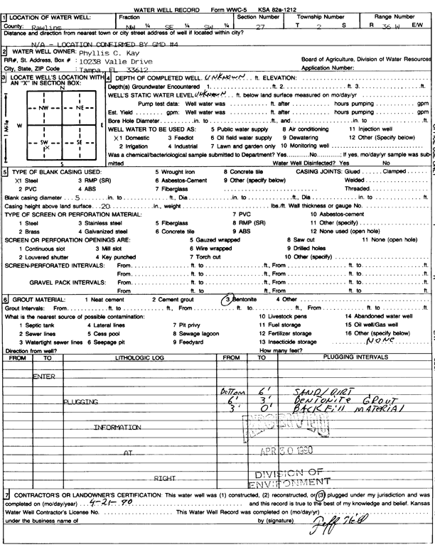
T2S, R36W, Sec. 27 NW SE SW |
Kay, Phyllis | Domestic | Plugged | 21-Apr-1990 | Scan | ||||
|
T2S, R36W, Sec. 28 NE SE NW NE |
CME Inc/Antholz, Carl | 300 ft. | 200 ft. | 50 gpm. | Oil Field Water Supply | CME 1-28 | Plugged | 11-May-2015 | |
|
T2S, R36W, Sec. 28 NE SE NW NE |
CME Inc/Antholz, Carl | 300 ft. | 200 ft. | 50 gpm. | Oil Field Water Supply | CME 1-28 | Constructed | 21-Jan-2015 |
KOLAR |
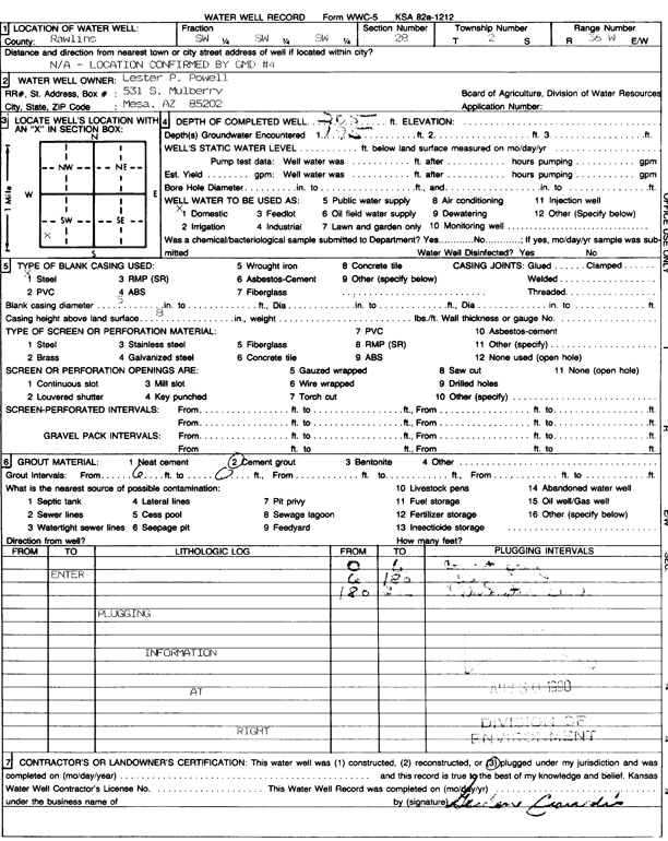
|
T2S, R36W, Sec. 28 SW SW SW |
Powell, Lester | 205 ft. | 195 ft. | Domestic | Plugged | 05-Aug-1990 | Scan | ||
|
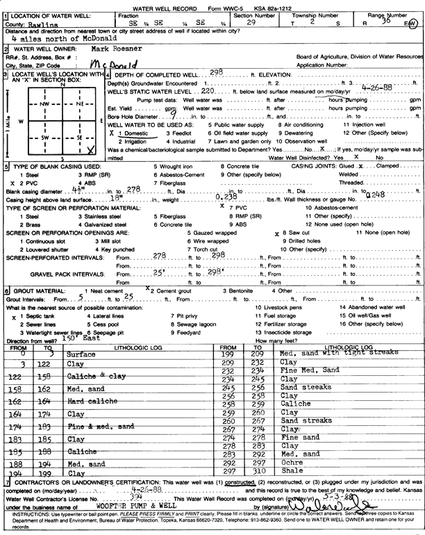
T2S, R36W, Sec. 29 SE SE SE |
Roesner, Mark | 298 ft. | 220 ft. | Domestic | Constructed | 26-Apr-1988 | Scan | ||
|
T2S, R36W, Sec. 30 NW NE NW SE |
Knapp, Jerry | 300 ft. | 220 ft. | Oil Field Water Supply | Knapp 1-30 | Plugged | 05-Sep-2014 |
KOLAR |
|
|
T2S, R36W, Sec. 30 NW NE NW SE |
Knapp, Jerry | 300 ft. | 220 ft. | 50 gpm. | Oil Field Water Supply | Knapp 1-30 | Constructed | 31-Jan-2013 |
KOLAR |
| View page: 1 || 2 || 3 || 4 || 5 || 6 || 7 || 8 || 9 || 10 || Next > | |||||||||