Select location of well to view details.
Click on column heading to sort.
|
|
|
County: Rice Select location of well to view details. Click on column heading to sort. |
|
|
|
| View page: < Prev || 11 || 12 || 13 || 14 || 15 || 16 || 17 || 18 || 19 || 20 || Next > | |||||||||
| T-R-S | Owner | Well Depth Ascend. Desc. |
Static Water Level Ascend. Desc. |
Est. Yield Ascend. Desc. |
Well Use | Other ID | Action Taken | Completion Date Ascend. Desc. |
Scan? |
|
T19S, R9W, Sec. 21 SW NW SE |
Gilbert-Stewart Operating | 70 ft. | 12 ft. | Oil Field Water Supply | Plugged | 11-Feb-2010 | |||
|
T19S, R9W, Sec. 21 SW NE SE |
Gilbert-Stewart Operating | 162 ft. | 16 ft. | Oil Field Water Supply | Constructed | 29-Jul-2011 | |||
|
T19S, R9W, Sec. 21 SW NW SE |
Gilbert-Stewart Operating | 70 ft. | 12 ft. | Oil Field Water Supply | Constructed | 11-Dec-2009 | |||
|
T19S, R9W, Sec. 21 SW NE SE |
Gilbert-Stewart Operating | 162 ft. | 16 ft. | Oil Field Water Supply | Plugged | 22-Sep-2011 | |||
|
T19S, R9W, Sec. 21 SE NW NW |
H-30 Drilling, Inc. | 60 ft. | 23 ft. | 60 gpm. | Oil Field Water Supply | Constructed | 29-May-1981 | ||
|
T19S, R9W, Sec. 21 C NW SW |
H-30 Drilling, Inc. | 50 ft. | 18 ft. | 60 gpm. | Oil Field Water Supply | Constructed | 28-Sep-1981 | ||
|
T19S, R9W, Sec. 21 NE NE SW |
Link, Bob | 30 ft. | 17 ft. | Domestic | Constructed | 31-Jan-1980 | |||
|
T19S, R9W, Sec. 21 W2 E2 SW SE |
Long, Darren (was Gilbert-Stewart Operating) | 165 ft. | 14 ft. | Domestic, changed from Oil Field Water Supply | Constructed | 19-Jul-2012 | |||
|
T19S, R9W, Sec. 22 C SW SW |
H-30 Drilling, Inc. | 127 ft. | 55 ft. | 50 gpm. | Oil Field Water Supply | Constructed | 30-Jul-1977 | ||
|
T19S, R9W, Sec. 23 NW SW NW |
White and Ellis Drilling, Inc. | 113 ft. | 57 ft. | 60 gpm. | Oil Field Water Supply | Constructed | 26-Feb-1982 | ||
|
T19S, R9W, Sec. 24 SW SW SE |
Chain, Mark | 74 ft. | 25 ft. | 60 gpm. | Domestic | Constructed | 24-Apr-1981 | ||
|
T19S, R9W, Sec. 25 SE SE NE |
Schechter, Tanner | 80 ft. | 28 ft. | Domestic, Livestock | Constructed | 11-Apr-2019 | |||
|
T19S, R9W, Sec. 26 SW SW NW |
Burdett, Paul | 58 ft. | 39 ft. | Domestic | Constructed | 12-Nov-1975 | |||
|
T19S, R9W, Sec. 26 SW SW NW |
Burdette, Paul | 80 ft. | 39 ft. | Domestic | Constructed | 12-Nov-1975 | |||
|
T19S, R9W, Sec. 28 SE NE SW |
Big Springs Drilling/Steffan, Louise | 60 ft. | 16 ft. | Oil Field Water Supply | Steffan 1 | Plugged | 03-Oct-1984 | ||
|
T19S, R9W, Sec. 28 SE NE SW |
Big Springs/Steffan, Louise | 80 ft. | 16 ft. | 60 gpm. | Oil Field Water Supply | Steffan 1 | Constructed | 20-Sep-1984 | |
|
T19S, R9W, Sec. 28 SW NW NE |
Duke Drilling Co./Auker, Fred | 80 ft. | 40 ft. | 60 gpm. | Oil Field Water Supply | Auker 1 | Constructed | 23-Jun-1987 | |
|
T19S, R9W, Sec. 28 NW NW NW |
Future Drilling | 62 ft. | 13 ft. | 60 gpm. | Oil Field Water Supply | Constructed | 29-Oct-1980 | ||
|
T19S, R9W, Sec. 28 NE SE NE |
Long, Robert | 107 ft. | 12 ft. | Domestic | Constructed | 30-May-2007 | |||
|
T19S, R9W, Sec. 29 C SW SW |
Damac Drilling Co. | 55 ft. | 11 ft. | 50 gpm. | Oil Field Water Supply | Constructed | 29-Oct-1977 | ||
|
T19S, R9W, Sec. 29 NW SE NW |
Duke Drilling Co. | 65 ft. | 12 ft. | Oil Field Water Supply | Grove 1 | Constructed | 11-Aug-1975 | ||
|
T19S, R9W, Sec. 29 SE NW SW |
Foster, Jeff | 53 ft. | 8 ft. | 60 gpm. | Oil Field Water Supply | Wallace 11-29 | Constructed | 24-Jul-2019 | |
|
T19S, R9W, Sec. 29 C SW NE |
H-30 Drilling, Inc. | 50 ft. | 15 ft. | 60 gpm. | Oil Field Water Supply | Constructed | 15-Feb-1980 | ||
|
T19S, R9W, Sec. 29 NW NE NW |
H-30 Drilling, Inc. | 60 ft. | 14 ft. | 60 gpm. | Oil Field Water Supply | Constructed | 05-Feb-1980 | ||
|
T19S, R9W, Sec. 30 SW SW NW |
Big Springs Drilling | 65 ft. | 19 ft. | 60 gpm. | Oil Field Water Supply | Constructed | 26-Oct-1979 | ||
|
T19S, R9W, Sec. 30 SE SE NW |
Bird Dog Oil | 90 ft. | 18 ft. | Oil Field Water Supply | Constructed | 13-Nov-2012 | |||
|
T19S, R9W, Sec. 30 W2 W2 SW |
L.D. Drilling Co. | 60 ft. | 15 ft. | Oil Field Water Supply | Coffman 1 | Constructed | 21-Nov-1980 | ||
|
T19S, R9W, Sec. 30 NE NW SW |
L.D. Drilling, Inc./Coffman, R.H. | 60 ft. | 18 ft. | Oil Field Water Supply | Coffman 1 | Constructed | 29-Mar-1985 | ||
|
T19S, R9W, Sec. 30 NE SE NE |
Link, Robert | 59 ft. | 24 ft. | Domestic | Constructed | 16-Apr-1988 | |||
|
T19S, R9W, Sec. 30 C SE SE |
Ramco Drilling Co. | 50 ft. | 18 ft. | 60 gpm. | Oil Field Water Supply | Constructed | 10-Dec-1980 | ||
|
T19S, R9W, Sec. 31 SW NE SE |
Brady, Mark | 72 ft. | 20 ft. | 50 gpm. | Domestic | Constructed | 13-Nov-2006 | ||
|
T19S, R9W, Sec. 31 SW SE NE |
Brady, Tamara and Mark | 60 ft. | 15 ft. | Domestic, Lawn and Garden | Constructed | 19-Mar-2026 |
KOLAR |
||
|
T19S, R9W, Sec. 31 NE NE NE |
Duke Drilling Co. | 61 ft. | 11 ft. | 60 gpm. | Oil Field Water Supply | Constructed | 15-May-1981 | ||
|
T19S, R9W, Sec. 31 NE NE SE |
Farmers Coop Union | 25 ft. | 12.92 ft. | Monitoring well/observation/piezometer | MW 5 | Constructed | 19-Mar-1993 | ||
|
T19S, R9W, Sec. 31 SE NE SE |
Farmers Coop Union | 25 ft. | 11.12 ft. | Monitoring well/observation/piezometer | MW 7 | Constructed | 23-Mar-1993 | ||
|
T19S, R9W, Sec. 31 NE NE SE |
Farmers Coop Union | 19 ft. | 12.51 ft. | Monitoring well/observation/piezometer | MW 1 | Constructed | 19-Mar-1993 | ||
|
T19S, R9W, Sec. 31 NE NE SE |
Farmers Coop Union | 25 ft. | 12.09 ft. | Monitoring well/observation/piezometer | MW 2 | Constructed | 19-Mar-1993 | ||
|
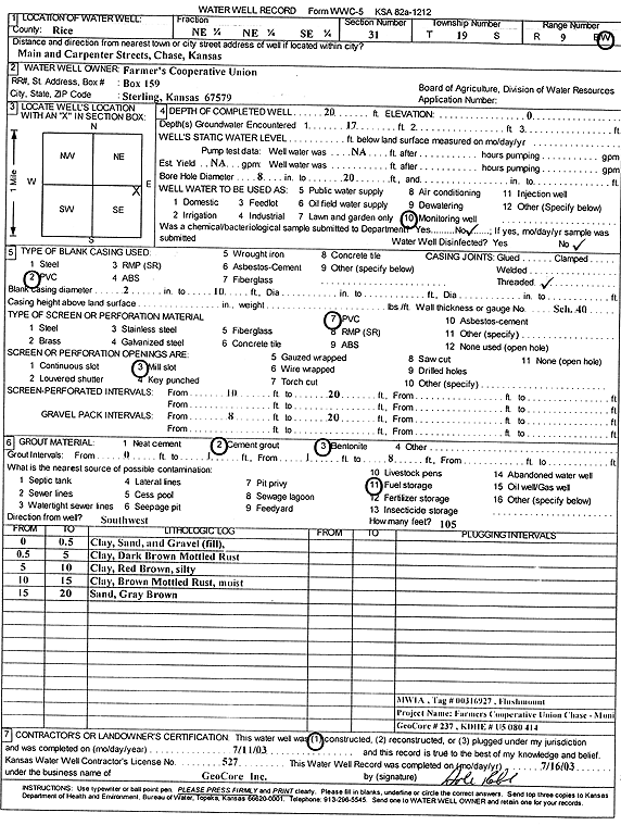
T19S, R9W, Sec. 31 NE NE SE |
Farmers Coop Union | 20 ft. | Monitoring well/observation/piezometer | MW 1A | Constructed | 11-Jul-2003 | Scan | ||
|
T19S, R9W, Sec. 31 NE NE SE |
Farmers Coop Union | 25 ft. | 11.9 ft. | Monitoring well/observation/piezometer | MW 3 | Constructed | 19-Mar-1993 | ||
|
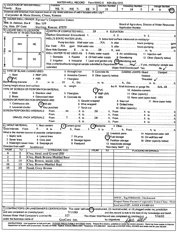
T19S, R9W, Sec. 31 NE NE SE |
Farmers Coop Union | 20 ft. | Monitoring well/observation/piezometer | MW 11 | Constructed | 11-Jul-2003 | Scan | ||
|
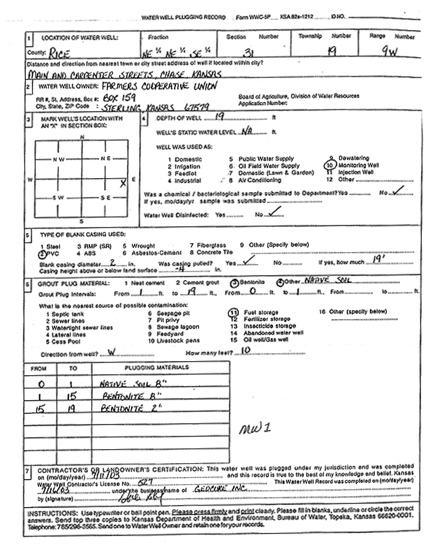
T19S, R9W, Sec. 31 NE NE SE |
Farmers Coop Union | 19 ft. | Monitoring well/observation/piezometer | MW 1 | Plugged | 11-Jul-2003 | Scan | ||
|
T19S, R9W, Sec. 31 NE NE SE |
Farmers Coop Union | 30 ft. | 18 ft. | Monitoring well/observation/piezometer | Constructed | 31-Jul-1992 | |||
|
T19S, R9W, Sec. 31 SE NE SE |
Farmers Coop Union | 25 ft. | 10.88 ft. | Monitoring well/observation/piezometer | MW 10 | Constructed | 24-Mar-1993 | ||
|
T19S, R9W, Sec. 31 NE SW SW |
Gillespie, Jim | 90 ft. | 27 ft. | Domestic | Constructed | 25-Jul-1980 | |||
|
T19S, R9W, Sec. 31 SE SE NW |
Hargadine, Loren | 70 ft. | 18 ft. | 60 gpm. | Domestic, Lawn and Garden | Constructed | 27-Jun-1994 | ||
|
T19S, R9W, Sec. 31 NE NE SE |
Pump Mart | 30 ft. | 11.34 ft. | Monitoring well/observation/piezometer | MW 5 | Constructed | 01-Jun-1998 | ||
|
T19S, R9W, Sec. 31 NE NE SE |
Pump Mart | 30 ft. | 17.68 ft. | Monitoring well/observation/piezometer | MW 12 | Constructed | 03-Jun-1998 | ||
|
T19S, R9W, Sec. 31 NE NE SE |
Pump Mart | 28.5 ft. | 11.84 ft. | Monitoring well/observation/piezometer | MW 1 | Constructed | 28-May-1998 | ||
|
T19S, R9W, Sec. 31 NE NE SE |
Pump Mart | 30 ft. | 12.1 ft. | Monitoring well/observation/piezometer | MW 11 | Constructed | 03-Jun-1998 | ||
|
T19S, R9W, Sec. 31 NE NE SE |
Pump Mart | 30 ft. | 16.84 ft. | Monitoring well/observation/piezometer | MW 10 | Constructed | 02-Jun-1998 | ||
| View page: < Prev || 11 || 12 || 13 || 14 || 15 || 16 || 17 || 18 || 19 || 20 || Next > | |||||||||