Select location of well to view details.
Click on column heading to sort.
|
|
|
County: Rice Select location of well to view details. Click on column heading to sort. |
|
|
|
| View page: < Prev || 21 || 22 || 23 || 24 || 25 || 26 || 27 || 28 || 29 || 30 || Next > | |||||||||
| T-R-S | Owner | Well Depth Ascend. Desc. |
Static Water Level Ascend. Desc. |
Est. Yield Ascend. Desc. |
Well Use | Other ID | Action Taken | Completion Date Ascend. Desc. |
Scan? |
|
T19S, R10W, Sec. 19 SE NE SW |
Duke Drilling/Tripett, Bill | 60 ft. | 10 ft. | 60 gpm. | Oil Field Water Supply | Tripett 2 A | Constructed | 15-Nov-1985 | |
|
T19S, R10W, Sec. 19 SW NW SW |
Elsen, Shawn | 58 ft. | 13.5 ft. | Domestic | Constructed | 22-Mar-1996 | |||
|
T19S, R10W, Sec. 19 SW NW SW |
Hager, George | 50 ft. | 19 ft. | Domestic, Livestock | Constructed | 09-Jan-1984 | |||
|
T19S, R10W, Sec. 19 C W2 SW |
Isern, Stan | 61 ft. | 23 ft. | Oil Field Water Supply | Constructed | 11-May-1987 | |||
|
T19S, R10W, Sec. 19 SE SE SE |
White and Ellis/Richardson, Jack | 95 ft. | 20 ft. | 60 gpm. | Oil Field Water Supply | Richardson 1 | Constructed | 16-Dec-1983 | |
|
T19S, R10W, Sec. 19 C SW SW |
Woodman-Iannitti Drilling Co. | 62 ft. | 16 ft. | 50 gpm. | Oil Field Water Supply | Constructed | 17-Aug-1978 | ||
|
T19S, R10W, Sec. 20 |
Coleman, Clark | 105 ft. | 400 gpm. | (unstated)/abandoned | Constructed | 17-Sep-1971 | |||
|
T19S, R10W, Sec. 20 NE NE NW |
Hupfer Operating | 75 ft. | 10 ft. | Oil Field Water Supply | Plugged | 02-Oct-2014 | |||
|
T19S, R10W, Sec. 20 NE NE NW |
Hupfer Operating | 75 ft. | 10 ft. | Oil Field Water Supply | Constructed | 19-Aug-2014 | |||
|
T19S, R10W, Sec. 20 C SW |
Ringwald, Mike | 53 ft. | 18 ft. | Irrigation | Well 3 | Constructed | 12-Feb-1991 | ||
|
T19S, R10W, Sec. 20 C SW |
Ringwald, Mike | 57 ft. | 19 ft. | Irrigation | Well 1 | Constructed | 13-Feb-1991 | ||
|
T19S, R10W, Sec. 20 C SW |
Ringwald, Mike | 57 ft. | 18 ft. | Irrigation | Well 2 | Constructed | 13-Feb-1991 | ||
|
T19S, R10W, Sec. 20 C SW |
Ringwald, Mike | 55 ft. | 18 ft. | Irrigation | Well 4 | Constructed | 12-Feb-1991 | ||
|
T19S, R10W, Sec. 20 NW SE SE |
Sterling Drilling Co./Thomas, Robert | 68 ft. | 16 ft. | 50 gpm. | Oil Field Water Supply | Wolf 1 | Constructed | 10-Nov-1997 | |
|
T19S, R10W, Sec. 21 NE SE NE |
American Warrior, Inc. | 60 ft. | 17 ft. | Oil Field Water Supply | Constructed | 01-May-2012 | |||
|
T19S, R10W, Sec. 21 NE SE NE |
American Warrior, Inc. | 60 ft. | 13 ft. | Oil Field Water Supply | Plugged | 12-Oct-2012 | |||
|
T19S, R10W, Sec. 21 SW NW NE |
Coleman, Cameron | 60 ft. | 18 ft. | Domestic, Livestock | Constructed | 17-Oct-2022 |
KOLAR |
||
|
T19S, R10W, Sec. 21 C SW |
Duke Drilling/Dewerff, Dale | 80 ft. | 13 ft. | 60 gpm. | Oil Field Water Supply | DeWerff 1 | Constructed | 19-Dec-1987 | |
|
T19S, R10W, Sec. 21 NE NW NW |
Eatinger, Richard (was American Warrior, Inc.) | 70 ft. | 18 ft. | Domestic, changed from Oil Field Water Supply | Constructed | 21-May-2012 | |||
|
T19S, R10W, Sec. 21 NE NE SE |
Heine, Alvin | 58 ft. | 22 ft. | Domestic | Constructed | 25-Nov-1991 | |||
|
T19S, R10W, Sec. 21 NE NE NE |
Linke, Austin | 65 ft. | 22 ft. | Domestic | Constructed | 26-Aug-1986 | |||
|
T19S, R10W, Sec. 21 NE NE NE |
Linke, Tom and Shelly | 80 ft. | 23 ft. | Domestic | Constructed | 18-Jan-2016 | |||
|
T19S, R10W, Sec. 22 NE NW SW |
Big Springs Drilling | 65 ft. | 18 ft. | 60 gpm. | Oil Field Water Supply | Constructed | 14-May-1981 | ||
|
T19S, R10W, Sec. 22 SE NE NW |
H-30 Drilling/Dobrinski, Art | 65 ft. | 20 ft. | 60 gpm. | Oil Field Water Supply | Dobrinski 1 | Constructed | 13-Dec-1984 | |
|
T19S, R10W, Sec. 22 NE NE NE |
Northern Gas Products | 85 ft. | 19 ft. | Industrial | Plugged | 06-Jan-1984 | |||
|
T19S, R10W, Sec. 22 SE SE NE |
Northern Gas Products Co. | 76 ft. | 16.25 ft. | 1000 gpm. | Industrial | Well 923 A 11 | Constructed | 27-Oct-1981 | |
|
T19S, R10W, Sec. 22 SE SE NE |
Northern Gas Products Co. | 74 ft. | Industrial | Plugged | 23-Oct-1981 | ||||
|
T19S, R10W, Sec. 22 SW SW NE |
Northern Liquid Fuels Co. | 68 ft. | 33.5 ft. | Monitoring well/observation/piezometer | PZ D | Constructed | 29-Apr-1981 | ||
|
T19S, R10W, Sec. 22 SW SW NE |
Northern Liquid Fuels Co. | 64 ft. | 28 ft. | Monitoring well/observation/piezometer | PZ C | Constructed | 28-Apr-1981 | ||
|
T19S, R10W, Sec. 22 SW SE NE |
Northern Liquid Fuels Co. | 73 ft. | 21.5 ft. | Monitoring well/observation/piezometer | PZ F | Constructed | 29-Apr-1981 | ||
|
T19S, R10W, Sec. 22 SW NW NE |
Northern Liquid Fuels Co. | 71 ft. | 27 ft. | Monitoring well/observation/piezometer | PZ 6 | Constructed | 29-Apr-1981 | ||
|
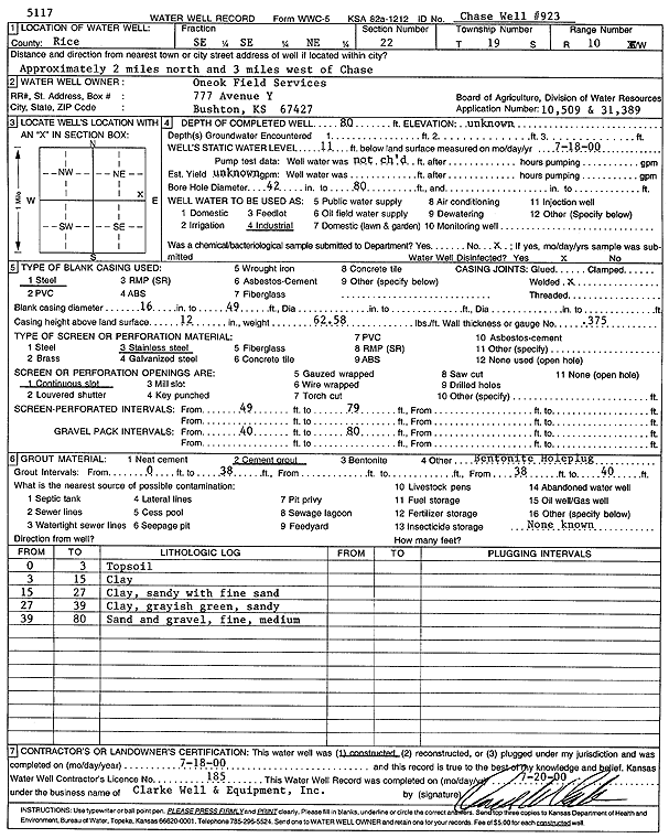
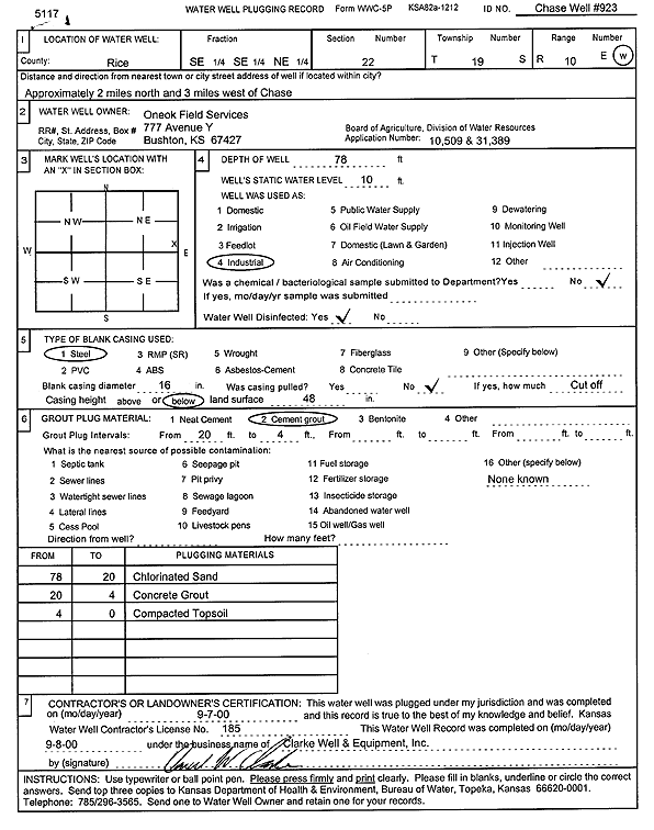
T19S, R10W, Sec. 22 SE SE NE |
Oneok Field Services | 80 ft. | 11 ft. | Industrial | Chase Well 923 | Constructed | 18-Jul-2000 | Scan | |
|
T19S, R10W, Sec. 22 SE SE NE |
Oneok Field Services | 78 ft. | 10 ft. | Industrial | Chase Well 923 | Plugged | 07-Sep-2000 | Scan | |
|
T19S, R10W, Sec. 22 SW SW NE |
ONEOK Hydrocarbon, LP | 48.5 ft. | 14 ft. | Monitoring well/observation/piezometer | CP 6 | Plugged | 15-Sep-2011 | ||
|
T19S, R10W, Sec. 22 NW NW NE |
ONEOK Hydrocarbon, LP | 49.5 ft. | 8 ft. | Monitoring well/observation/piezometer | CP 4 | Plugged | 15-Sep-2011 | ||
|
T19S, R10W, Sec. 22 NE NE NE |
ONEOK Hydrocarbon, LP | Monitoring well/observation/piezometer | CP 2 | Plugged | 15-Sep-2011 | ||||
|
T19S, R10W, Sec. 22 SW NW NE |
ONEOK Hydrocarbon, LP | 74.5 ft. | 14 ft. | Monitoring well/observation/piezometer | CP 8 | Plugged | 15-Sep-2011 | ||
|
T19S, R10W, Sec. 22 NE NE NE |
ONEOK Hydrocarbon, LP | Monitoring well/observation/piezometer | CP 3 | Plugged | 15-Sep-2011 | ||||
|
T19S, R10W, Sec. 22 NE NE NE |
ONEOK Hydrocarbon, LP | 82 ft. | 15 ft. | Monitoring well/observation/piezometer | CP 1 | Plugged | 15-Sep-2011 | ||
|
T19S, R10W, Sec. 22 SW SW NE |
ONEOK Hydrocarbon, LP | 64 ft. | 13 ft. | Monitoring well/observation/piezometer | CP 7 | Plugged | 15-Sep-2011 | ||
|
T19S, R10W, Sec. 22 SW SE NE |
ONEOK Hydrocarbon, LP | 74.25 ft. | 14.5 ft. | Monitoring well/observation/piezometer | CP 5 | Plugged | 15-Sep-2011 | ||
|
T19S, R10W, Sec. 22 SE SE NE |
Oneok Hydrocarbon, LP | 80.43 ft. | 9.7 ft. | Industrial | Chase Well 923 | Reconstructed | 13-Jul-2016 | ||
|
T19S, R10W, Sec. 22 NE NE NE |
UPG, Inc/Hydrocarbon Transportation | 88 ft. | 19 ft. | 800 gpm. | Industrial | Well 921 A 9 | Constructed | 06-Jan-1984 | |
|
T19S, R10W, Sec. 23 NE NE SW |
Ritchie Exploration, Inc. | 79 ft. | 11 ft. | Oil Field Water Supply | Constructed | 15-Nov-1993 | |||
|
T19S, R10W, Sec. 23 NW NW SE |
Sterling Drilling Co. | 80 ft. | 30 ft. | Oil Field Water Supply | Jenkins 1 | Constructed | 14-Sep-1981 | ||
|
T19S, R10W, Sec. 23 SW NW NE |
Sterling Drilling Co. | 60 ft. | 10 ft. | Oil Field Water Supply | Doll 1 | Constructed | 01-Jan-1983 | ||
|
T19S, R10W, Sec. 23 NW SE NE |
Stickney, Leroy (was Bird Dog Oil) | 70 ft. | 14 ft. | Domestic, changed from Oil Field Water Supply | Constructed | 19-Apr-2012 | |||
|
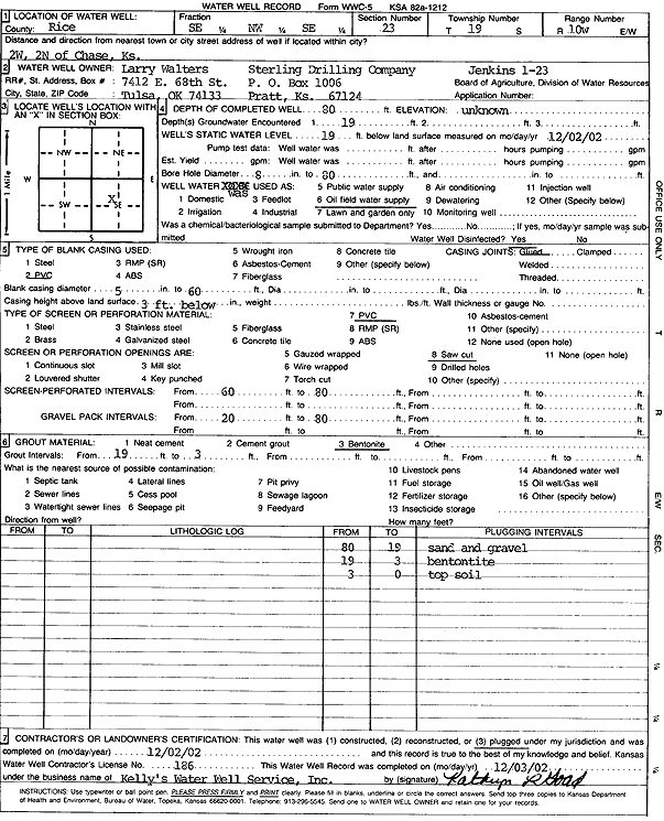
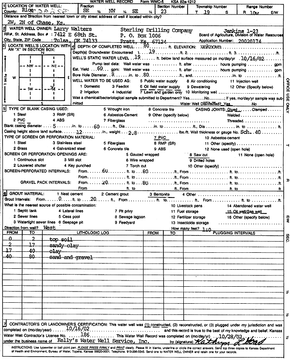
T19S, R10W, Sec. 23 SE NW SE |
Walters, Larry | 80 ft. | 19 ft. | Oil Field Water Supply | Jenkins 1-23 | Plugged | 02-Dec-2002 | Scan | |
|
T19S, R10W, Sec. 23 SE NW SE |
Walters, Larry | 80 ft. | 19 ft. | 60 gpm. | Oil Field Water Supply | Jenkins 1-23 | Constructed | 16-Oct-2002 | Scan |
|
T19S, R10W, Sec. 23 NE SW NW |
Woodman and Iannitti Oil Co. | 75 ft. | 15 ft. | 60 gpm. | Oil Field Water Supply | Constructed | 07-Nov-1980 | ||
| View page: < Prev || 21 || 22 || 23 || 24 || 25 || 26 || 27 || 28 || 29 || 30 || Next > | |||||||||