Select location of well to view details.
Click on column heading to sort.
|
|
|
County: Rice Select location of well to view details. Click on column heading to sort. |
|
|
|
| View page: < Prev || 31 || 32 || 33 || 34 || 35 || 36 || 37 || 38 || 39 || 40 || Next > | |||||||||
| T-R-S | Owner | Well Depth Ascend. Desc. |
Static Water Level Ascend. Desc. |
Est. Yield Ascend. Desc. |
Well Use | Other ID | Action Taken | Completion Date Ascend. Desc. |
Scan? |
|
T20S, R8W, Sec. 4 SW SE NW SE |
McCormick, Charles | 81 ft. | 36 ft. | 100 gpm. | Domestic, Lawn and Garden | Constructed | 20-Sep-2016 |
KOLAR |
|
|
T20S, R8W, Sec. 4 NW NE SW SE |
Milburn, Charles | 82 ft. | 28.5 ft. | 100 gpm. | Domestic, Lawn and Garden | Constructed | 23-Jul-2019 |
KOLAR |
|
|
T20S, R8W, Sec. 4 SW SW NW |
Nickles, Charles | 60 ft. | 31 ft. | Heat Pump (Closed Loop/Disposal), Geothermal | Constructed | 09-May-2011 | |||
|
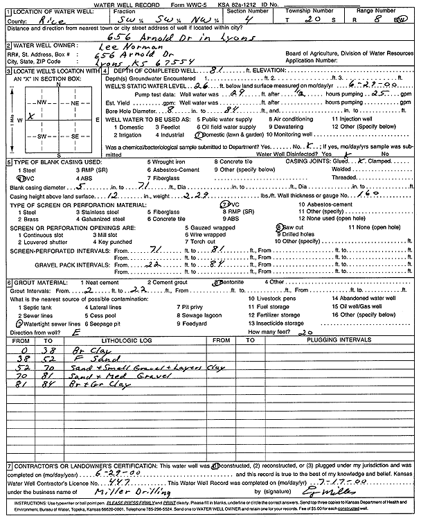
T20S, R8W, Sec. 4 SW SW NW |
Norman, Lee | 81 ft. | 26 ft. | Domestic, Lawn and Garden | Constructed | 29-Jun-2000 | Scan | ||
|
T20S, R8W, Sec. 4 SE SW NW SE |
Oliver, Guy | 75 ft. | 41 ft. | Domestic, Lawn and Garden | Constructed | 23-Apr-2012 | |||
|
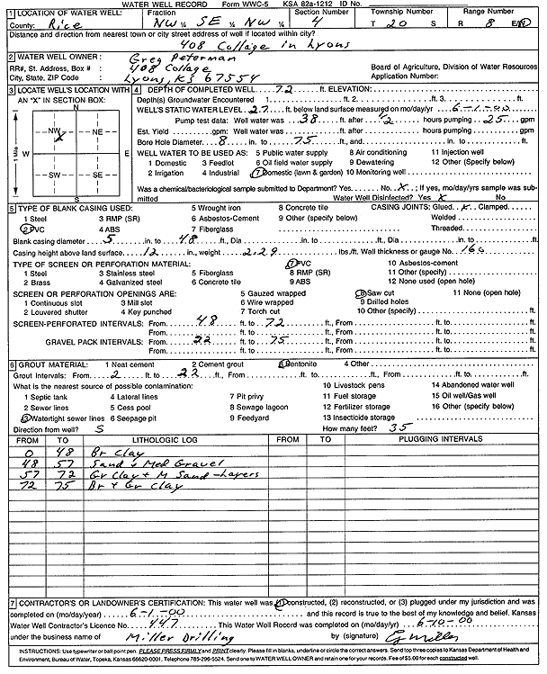
T20S, R8W, Sec. 4 NW SE NW |
Peterman, Greg | 72 ft. | 27 ft. | Domestic, Lawn and Garden | Constructed | 01-Jun-2000 | Scan | ||
|
T20S, R8W, Sec. 4 NE NW NW |
Rolfs, Jean | 36 ft. | 8 ft. | Domestic | Plugged | 04-Nov-1997 | |||
|
T20S, R8W, Sec. 4 SE SW NE NW |
Schulz, Dustin | 65 ft. | 30 ft. | 30 gpm. | Domestic, Lawn and Garden | Constructed | 13-Jul-2015 |
KOLAR |
|
|
T20S, R8W, Sec. 4 SE NE SW SE |
Sherman, Tom | 64 ft. | 37 ft. | 50 gpm. | Domestic, Lawn and Garden | Constructed | 15-Sep-2011 |
KOLAR |
|
|
T20S, R8W, Sec. 4 C NW |
Sieman, Dr. | 61 ft. | 18 ft. | 50 gpm. | Domestic | Constructed | 03-Oct-1978 | ||
|
T20S, R8W, Sec. 4 SW NE SW SE |
St Paul Catholic Church | 70 ft. | 47 ft. | 50 gpm. | Domestic, Lawn and Garden | Constructed | 24-Sep-2012 |
KOLAR |
|
|
T20S, R8W, Sec. 4 NW SW SW SE |
Stegman, Don | 80 ft. | 30.6 ft. | Domestic | Constructed | 18-Sep-2019 | |||
|
T20S, R8W, Sec. 4 SW SW SE NW |
Timberlake, Rollie | 70 ft. | 23 ft. | Domestic, Lawn and Garden | Constructed | 17-Sep-2019 | |||
|
T20S, R8W, Sec. 4 SE SW NW |
Young, Larry | 78 ft. | 44 ft. | 50 gpm. | Air Conditioning | Constructed | 09-Apr-1986 | ||
|
T20S, R8W, Sec. 4 SE SW NW |
Young, Larry | 82 ft. | 45 ft. | 40 gpm. | Air Conditioning | Constructed | 09-Apr-1986 | ||
|
T20S, R8W, Sec. 4 NE NE SW NE |
Zwick, Craig | 79 ft. | 50 ft. | 18 gpm. | Domestic, Lawn and Garden | Constructed | 27-Jun-2013 |
KOLAR |
|
|
T20S, R8W, Sec. 4 NW SE NW |
Zwick, Craig | 70 ft. | 30 ft. | 15 gpm. | Domestic, Lawn and Garden | Constructed | 16-Oct-2025 |
KOLAR |
|
|
T20S, R8W, Sec. 5 NE NE NW |
City of Lyons | 40 ft. | Monitoring well/observation/piezometer | MW 11 | Constructed | 11-Nov-2014 | |||
|
T20S, R8W, Sec. 5 NE NE NE NW |
City of Lyons | 44.8 ft. | 31.75 ft. | Monitoring well/observation/piezometer | MW 2 | Plugged | 26-Apr-2017 | ||
|
T20S, R8W, Sec. 5 NE NE NE NW |
City of Lyons | 44.78 ft. | 32.29 ft. | Monitoring well/observation/piezometer | MW 1 | Plugged | 26-Apr-2017 | ||
|
T20S, R8W, Sec. 5 NW NW NE |
City of Lyons | 40 ft. | 31.1 ft. | Monitoring well/observation/piezometer | MW 9 | Constructed | 30-Aug-2013 | ||
|
T20S, R8W, Sec. 5 NE NE NW |
City of Lyons | 40 ft. | Monitoring well/observation/piezometer | MW 10 | Constructed | 11-Nov-2014 | |||
|
T20S, R8W, Sec. 5 SE NE NE NW |
City of Lyons | 39.85 ft. | 32.68 ft. | Monitoring well/observation/piezometer | MW 4 | Plugged | 26-Apr-2017 | ||
|
T20S, R8W, Sec. 5 SE NE NE NW |
City of Lyons | 39.88 ft. | 32.75 ft. | Monitoring well/observation/piezometer | MW 6 | Plugged | 26-Apr-2017 | ||
|
T20S, R8W, Sec. 5 NE NE NW |
City of Lyons | 45 ft. | 31.03 ft. | Monitoring well/observation/piezometer | MW 1 | Constructed | 26-Aug-2013 | ||
|
T20S, R8W, Sec. 5 NE NE NW |
City of Lyons | 45 ft. | 30.21 ft. | Monitoring well/observation/piezometer | MW 2 | Constructed | 26-Aug-2013 | ||
|
T20S, R8W, Sec. 5 NE NE NW |
City of Lyons | 40 ft. | 30.93 ft. | Monitoring well/observation/piezometer | MW 3 | Constructed | 27-Aug-2013 | ||
|
T20S, R8W, Sec. 5 NE NE NW |
City of Lyons | 40 ft. | 30.21 ft. | Monitoring well/observation/piezometer | MW 4 | Constructed | 27-Aug-2013 | ||
|
T20S, R8W, Sec. 5 NE NE NW |
City of Lyons | 40 ft. | 29.91 ft. | Monitoring well/observation/piezometer | MW 7 | Constructed | 28-Aug-2013 | ||
|
T20S, R8W, Sec. 5 NW NW NE |
City of Lyons | 40 ft. | 30.91 ft. | Monitoring well/observation/piezometer | MW 8 | Constructed | 29-Aug-2013 | ||
|
T20S, R8W, Sec. 5 NE NE NW |
City of Lyons | 40 ft. | 31.02 ft. | Monitoring well/observation/piezometer | MW 5 | Constructed | 27-Aug-2013 | ||
|
T20S, R8W, Sec. 5 NE NE NW |
City of Lyons | 40 ft. | 30.56 ft. | Monitoring well/observation/piezometer | MW 6 | Constructed | 28-Aug-2013 | ||
|
T20S, R8W, Sec. 5 NW SW NW |
City of Lyons | 60 ft. | 25 ft. | Monitoring well/observation/piezometer | Constructed | 25-Jun-1990 | |||
|
T20S, R8W, Sec. 5 NE NE NE NW |
City of Lyons | 39.66 ft. | 32.08 ft. | Monitoring well/observation/piezometer | MW 3 | Plugged | 26-Apr-2017 | ||
|
T20S, R8W, Sec. 5 SE NE NE NW |
City of Lyons | 39.8 ft. | 32.61 ft. | Monitoring well/observation/piezometer | MW 7 | Plugged | 26-Apr-2017 | ||
|
T20S, R8W, Sec. 5 NW NW NW NE |
City of Lyons | 39.18 ft. | 32.18 ft. | Monitoring well/observation/piezometer | MW 8 | Plugged | 26-Apr-2017 | ||
|
T20S, R8W, Sec. 5 NE NE NE NW |
City of Lyons | 39.79 ft. | 32.32 ft. | Monitoring well/observation/piezometer | MW 5 | Plugged | 26-Apr-2017 | ||
|
T20S, R8W, Sec. 5 SE NE NE NW |
City of Lyons | 39.65 ft. | 33.02 ft. | Monitoring well/observation/piezometer | MW 10 | Plugged | 26-Apr-2017 | ||
|
T20S, R8W, Sec. 5 SE NE NE NW |
City of Lyons | 39.65 ft. | 32.75 ft. | Monitoring well/observation/piezometer | MW 11 | Plugged | 26-Apr-2017 | ||
|
T20S, R8W, Sec. 5 SW NW NW NE |
City of Lyons | 39.77 ft. | 32.26 ft. | Monitoring well/observation/piezometer | MW 9 | Plugged | 26-Apr-2017 | ||
|
T20S, R8W, Sec. 5 NW SE SE |
Ebright, Wendell | 83 ft. | 29 ft. | 900 gpm. | Irrigation | Constructed | 07-Feb-1984 | ||
|
T20S, R8W, Sec. 5 SE SW SW |
Koons, Wayne | 53 ft. | 20 ft. | Domestic | Constructed | 27-Feb-1984 | |||
|
T20S, R8W, Sec. 5 NW NE NW |
Raymond Oil | 65 ft. | 29 ft. | Domestic | Constructed | 12-Feb-1992 | |||
|
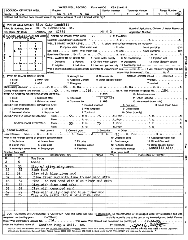
T20S, R8W, Sec. 5 NW SW NW |
Rice City Landfill | 72 ft. | 13 ft. | Monitoring well/observation/piezometer | MW 3 | Constructed | 20-Aug-1998 | Scan | |
|
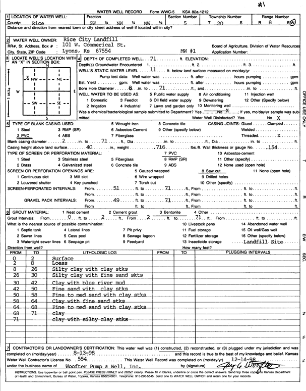
T20S, R8W, Sec. 5 SW NW NW |
Rice City Landfill | 71 ft. | 11 ft. | Monitoring well/observation/piezometer | MW 1 | Constructed | 13-Aug-1998 | Scan | |
|
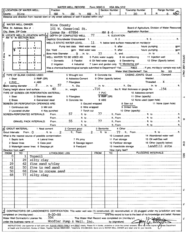
T20S, R8W, Sec. 5 NW SW NW |
Rice County | 77 ft. | 11 ft. | Monitoring well/observation/piezometer | MW 4 | Constructed | 20-Aug-1998 | Scan | |
|
T20S, R8W, Sec. 5 NW NW NE |
Rice County Airport | 42 ft. | 35.4 ft. | Monitoring well/observation/piezometer | MW 8 | Constructed | 27-Mar-1995 | ||
|
T20S, R8W, Sec. 5 NE NW NE |
Rice County Airport | 39 ft. | 35.1 ft. | Monitoring well/observation/piezometer | MW 1 | Constructed | 27-Mar-1995 | ||
|
T20S, R8W, Sec. 5 SW NE NW NE |
Rice County Airport | 44 ft. | 36.4 ft. | Monitoring well/observation/piezometer | MW 13 | Constructed | 26-Jul-2017 | ||
|
T20S, R8W, Sec. 5 NW NW NE |
Rice County Airport | 42 ft. | 34.3 ft. | Monitoring well/observation/piezometer | MW 9 | Constructed | 27-Mar-1995 | ||
| View page: < Prev || 31 || 32 || 33 || 34 || 35 || 36 || 37 || 38 || 39 || 40 || Next > | |||||||||