Select location of well to view details.
Click on column heading to sort.
|
|
|
County: Riley Select location of well to view details. Click on column heading to sort. |
|
|
|
| View page: < Prev || 41 || 42 || 43 || 44 || 45 || 46 || 47 || 48 || 49 || 50 || Next > | |||||||||
| T-R-S | Owner | Well Depth Ascend. Desc. |
Static Water Level Ascend. Desc. |
Est. Yield Ascend. Desc. |
Well Use | Other ID | Action Taken | Completion Date Ascend. Desc. |
Scan? |
|
T10S, R8E, Sec. 17 SW SE NE |
City of Manhattan | 40 ft. | 15 ft. | 30 gpm. | Monitoring well/observation/piezometer | A | Constructed | 03-Dec-1996 | |
|
T10S, R8E, Sec. 17 SW SW |
City of Manhattan | 30 ft. | 17 ft. | Monitoring well/observation/piezometer | Constructed | 13-Sep-1986 | |||
|
T10S, R8E, Sec. 17 SW SW NE |
City of Manhattan | 28 ft. | 15 ft. | 20 gpm. | Monitoring well/observation/piezometer | A | Constructed | 29-Nov-1996 | |
|
T10S, R8E, Sec. 17 SW SW NE |
City of Manhattan | 40 ft. | 15.97 ft. | Monitoring well/observation/piezometer | 16 B | Constructed | 16-Mar-1999 | Scan | |
|
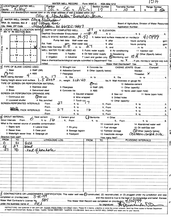
T10S, R8E, Sec. 17 SE SE NE |
City of Manhattan | 27 ft. | 14.57 ft. | Monitoring well/observation/piezometer | 15 A | Constructed | 15-Mar-1999 | Scan | |
|
T10S, R8E, Sec. 17 SE SE SW |
Cody, Micheal | 60 ft. | 23 ft. | 4 gpm. | Domestic | Constructed | 07-Oct-1980 | ||
|
T10S, R8E, Sec. 17 SE |
Cragg, Charles W. | 36 ft. | 15 ft. | 50 gpm. | Domestic | Constructed | 20-Dec-1984 | ||
|
T10S, R8E, Sec. 17 NW SE NE NW |
Darrah, Chris | 20 ft. | 16.15 ft. | Monitoring well/observation/piezometer | MW 11 | Constructed | 03-Jul-2017 | ||
|
T10S, R8E, Sec. 17 SW SE NE NW |
Darrah, Chris | 20 ft. | 16.34 ft. | Monitoring well/observation/piezometer | MW 10 | Constructed | 03-Jul-2017 | ||
|
T10S, R8E, Sec. 17 NW SE SW |
Darting, Pete | 40 ft. | 18 ft. | 40 gpm. | Domestic | Constructed | 13-Nov-1984 | ||
|
T10S, R8E, Sec. 17 NW SW SE |
Fairmont Heights Water Co | 46 ft. | 23 ft. | 230 gpm. | Public Water Supply | Well 3 | Constructed | 13-Apr-1981 | |
|
T10S, R8E, Sec. 17 SW SW SE |
Hammes, Thomas G | 36 ft. | 17 ft. | 50 gpm. | Domestic, Lawn and Garden | Constructed | 21-Jun-1995 | ||
|
T10S, R8E, Sec. 17 NE NW NW |
Hart, Verne | 35 ft. | 20 ft. | 15 gpm. | Domestic, Lawn and Garden | Constructed | 25-May-1992 | ||
|
T10S, R8E, Sec. 17 NE SW SE |
Hodge, Kim | 53 ft. | 19 ft. | 100 gpm. | Domestic | Constructed | 30-Jul-1996 | ||
|
T10S, R8E, Sec. 17 SE SE SE |
Kaw Valley Greenhouse | 45 ft. | 20 ft. | 50 gpm. | Domestic | Constructed | 17-Sep-1976 | ||
|
T10S, R8E, Sec. 17 SE SE NW |
Kaw Valley Greenhouse | 40 ft. | 14 ft. | 50 gpm. | Domestic | Constructed | 03-Sep-1985 | ||
|
T10S, R8E, Sec. 17 SE SE NW |
Kaw Valley Greenhouse | 40 ft. | 14 ft. | 50 gpm. | Domestic | Constructed | 03-Sep-1985 | ||
|
T10S, R8E, Sec. 17 SW SE SE |
Kaw Valley Greenhouse | 40 ft. | 16 ft. | 100 gpm. | Domestic | Constructed | 06-Aug-1986 | ||
|
T10S, R8E, Sec. 17 SE SW NW |
KDHE | 24.65 ft. | 15.95 ft. | Monitoring well/observation/piezometer | MW 4 | Constructed | 17-Dec-2009 | ||
|
T10S, R8E, Sec. 17 SE SW NW |
KDHE | 24.3 ft. | 16.73 ft. | Monitoring well/observation/piezometer | MW 1 | Constructed | 15-Dec-2009 | ||
|
T10S, R8E, Sec. 17 SE SW NW |
KDHE | 24.8 ft. | 17.3 ft. | Monitoring well/observation/piezometer | MW 3 | Constructed | 14-Dec-2009 | ||
|
T10S, R8E, Sec. 17 SW SW NW |
KDHE | 25.05 ft. | 16.4 ft. | Monitoring well/observation/piezometer | MW 5 | Constructed | 17-Dec-2009 | ||
|
T10S, R8E, Sec. 17 SE SW NW |
KDHE | 24.65 ft. | 16.32 ft. | Monitoring well/observation/piezometer | MW 2 | Constructed | 15-Dec-2009 | ||
|
T10S, R8E, Sec. 17 NE NW SW SE |
KDHE BER | 30 ft. | 19 ft. | Monitoring well/observation/piezometer | MW 3 | Plugged | 23-Aug-2019 |
KOLAR |
|
|
T10S, R8E, Sec. 17 NW SW SE |
KDHE T and M | 30 ft. | 19 ft. | Monitoring well/observation/piezometer | MW 1 | Constructed | 07-Feb-2008 | ||
|
T10S, R8E, Sec. 17 NW SW SE |
KDHE T and M | 30 ft. | 20 ft. | Monitoring well/observation/piezometer | MW 2 | Constructed | 07-Feb-2008 | ||
|
T10S, R8E, Sec. 17 NW SW SE |
KDHE T and M | 30 ft. | 19 ft. | Monitoring well/observation/piezometer | MW 3 | Constructed | 07-Feb-2008 | ||
|
T10S, R8E, Sec. 17 SW SW SW |
KDOT | 51 ft. | 17 ft. | Domestic | Plugged | 27-Oct-1993 | |||
|
T10S, R8E, Sec. 17 SW SW NE |
Mormon, Bill | 33 ft. | 17 ft. | 20 gpm. | Domestic | Constructed | 09-Nov-1995 | ||
|
T10S, R8E, Sec. 17 SE NE SW |
Riley County Public Works | 58 ft. | 20 ft. | 20 gpm. | Domestic | Plugged | 17-Dec-1994 | ||
|
T10S, R8E, Sec. 17 NW NW SE |
Riley County Public Works | 38 ft. | 18 ft. | 20 gpm. | Domestic | Plugged | 17-Dec-1994 | ||
|
T10S, R8E, Sec. 17 NW SE SW |
Riley County Public Works | 39 ft. | 19 ft. | 20 gpm. | Domestic | Plugged | 17-Dec-1994 | ||
|
T10S, R8E, Sec. 17 SE NE SE |
Riley County Public Works | 28 ft. | 17 ft. | 20 gpm. | Domestic | Plugged | 17-Dec-1994 | ||
|
T10S, R8E, Sec. 17 NW SE SW |
Riley County Public Works | 35 ft. | 13 ft. | 20 gpm. | Domestic | Plugged | 17-Dec-1994 | ||
|
T10S, R8E, Sec. 17 NW NW NE |
Riley County Public Works | 30 ft. | 16 ft. | 30 gpm. | Domestic | Plugged | 26-Jul-1995 | ||
|
T10S, R8E, Sec. 17 SE NE SW |
Riley County Public Works | 36 ft. | 16 ft. | 20 gpm. | Domestic | Plugged | 31-Mar-1995 | ||
|
T10S, R8E, Sec. 17 NW NW SW |
Riley County Public Works | 27 ft. | 18 ft. | 8 gpm. | Domestic | Plugged | 31-Mar-1995 | ||
|
T10S, R8E, Sec. 17 SW SW SW |
Riley County Public Works | 39 ft. | 21 ft. | 20 gpm. | Domestic | Plugged | 31-Mar-1995 | ||
|
T10S, R8E, Sec. 17 SE NW SW |
Riley County Public Works | 27 ft. | 16 ft. | 8 gpm. | Domestic | Plugged | 31-Mar-1995 | ||
|
T10S, R8E, Sec. 17 SE NW SE |
Riley County Public Works | 39 ft. | 18 ft. | 20 gpm. | Domestic | Plugged | 17-Dec-1994 | ||
|
T10S, R8E, Sec. 17 NW NW SE |
Riley County Public Works | 36 ft. | 18 ft. | 20 gpm. | Domestic | Plugged | 17-Dec-1994 | ||
|
T10S, R8E, Sec. 17 NW SE SW |
Sitton, Neil | 30 ft. | 16 ft. | 50 gpm. | Domestic | Constructed | 17-Jun-1988 | Scan | |
|
T10S, R8E, Sec. 17 NE NE |
Temple, Marge | 40 ft. | 28 ft. | Domestic | Plugged | 21-Sep-1989 | |||
|
T10S, R8E, Sec. 17 NE NW NW SW |
Velma L. Kuhn Trust | 20 ft. | 15.81 ft. | Monitoring well/observation/piezometer | MW 5 | Constructed | 01-Jul-2021 | ||
|
T10S, R8E, Sec. 17 NE NW NW SW |
Velma L. Kuhn Trust | 20 ft. | 16.8 ft. | Monitoring well/observation/piezometer | MW 6 | Constructed | 01-Jul-2021 | ||
|
T10S, R8E, Sec. 17 NE NW NW SW |
Velma L. Kuhn Trust | 24 ft. | 19.03 ft. | Monitoring well/observation/piezometer | MW 11 | Constructed | 08-Mar-2023 | ||
|
T10S, R8E, Sec. 17 NE NW NW SW |
Velma L. Kuhn Trust | 24 ft. | 18.19 ft. | Monitoring well/observation/piezometer | MW 10 | Constructed | 08-Mar-2023 | ||
|
T10S, R8E, Sec. 17 NE NW NW SW |
Velma L. Kuhn Trust | 20 ft. | 15.7 ft. | Domestic | MW 7 | Constructed | 01-Jul-2021 | ||
|
T10S, R8E, Sec. 17 SW NE NW SW |
Velma L. Kuhn Trust | 20 ft. | 16.42 ft. | Monitoring well/observation/piezometer | MW 8 | Constructed | 01-Jul-2021 | ||
|
T10S, R8E, Sec. 17 NE NW NW SW |
Velma L. Kuhn Trust | 20 ft. | 17.85 ft. | Monitoring well/observation/piezometer | MW 9 | Constructed | 01-Jul-2021 | ||
| View page: < Prev || 41 || 42 || 43 || 44 || 45 || 46 || 47 || 48 || 49 || 50 || Next > | |||||||||