Select location of well to view details.
Click on column heading to sort.
|
|
|
County: Rush Select location of well to view details. Click on column heading to sort. |
|
|
|
| View page: < Prev || 21 || 22 || 23 || 24 || 25 || 26 || 27 || 28 || 29 || 30 || Next > | |||||||||
| T-R-S | Owner | Well Depth Ascend. Desc. |
Static Water Level Ascend. Desc. |
Est. Yield Ascend. Desc. |
Well Use | Other ID | Action Taken | Completion Date Ascend. Desc. |
Scan? |
|
T18S, R18W, Sec. 22 SW SE SW |
Parker, Joan | 37 ft. | Monitoring well/observation/piezometer | MW 23 | Constructed | 24-Jan-1992 | |||
|
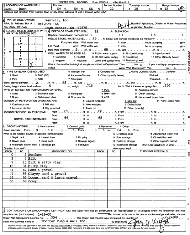
T18S, R18W, Sec. 22 SW SW SW |
Renzoil, Inc. | 50 ft. | 21.7 ft. | Environmental Remediation, Recovery | RW 2 | Constructed | 18-Mar-1996 | ||
|
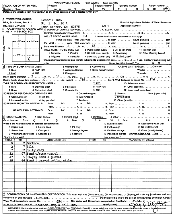
T18S, R18W, Sec. 22 SE SW SW |
Renzoil, Inc. | 50 ft. | 24.16 ft. | Monitoring well/observation/piezometer | MW north | Constructed | 18-Mar-1996 | ||
|
T18S, R18W, Sec. 22 SW SW SE |
Renzoil, Inc. | 69 ft. | Monitoring well/observation/piezometer | HX 5 D | Plugged | 12-Mar-2013 | |||
|
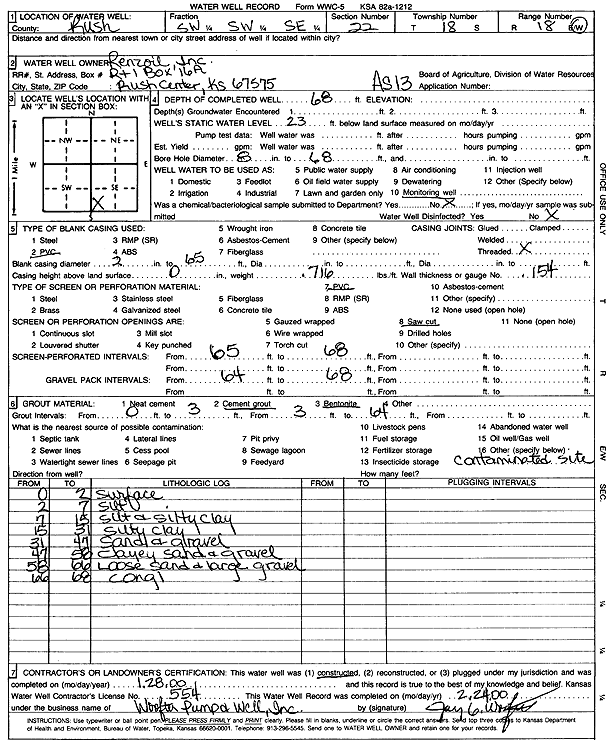
T18S, R18W, Sec. 22 SW SW SE |
Renzoil, Inc. | 68 ft. | 23 ft. | Environmental Remediation, Air Sparge | AS 13 | Constructed | 28-Jan-2000 | Scan | |
|
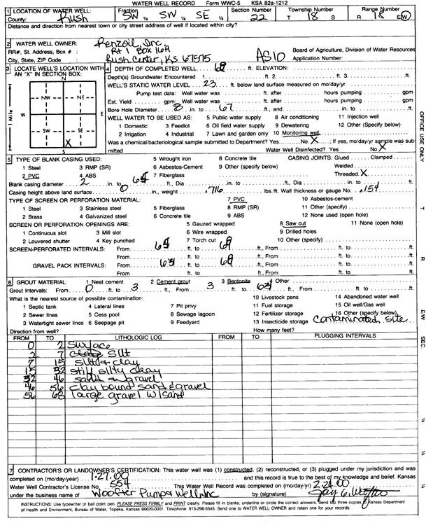
T18S, R18W, Sec. 22 SW SW SE |
Renzoil, Inc. | 68 ft. | 23 ft. | Environmental Remediation, Air Sparge | AS 10 | Constructed | 27-Jan-2000 | Scan | |
|
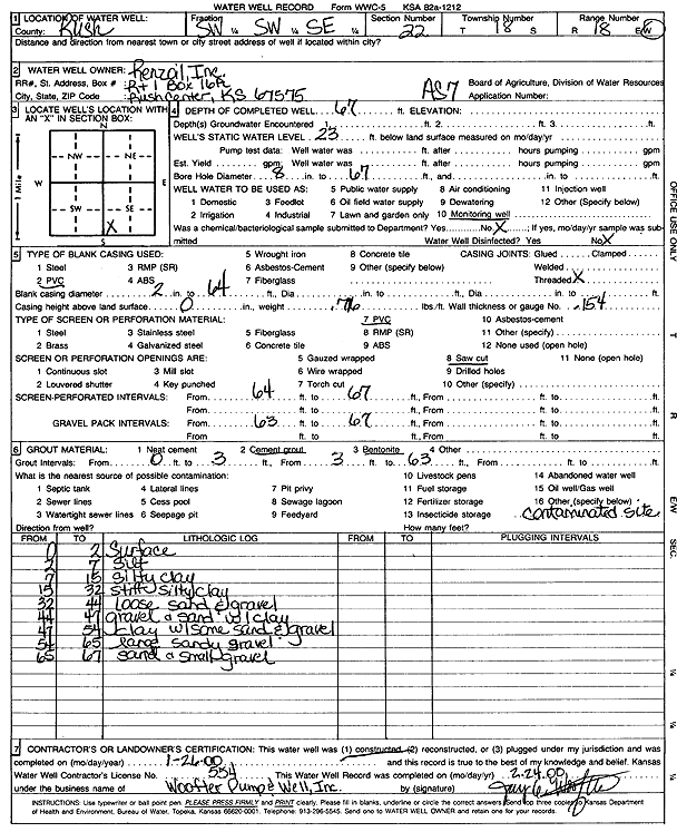
T18S, R18W, Sec. 22 SW SW SE |
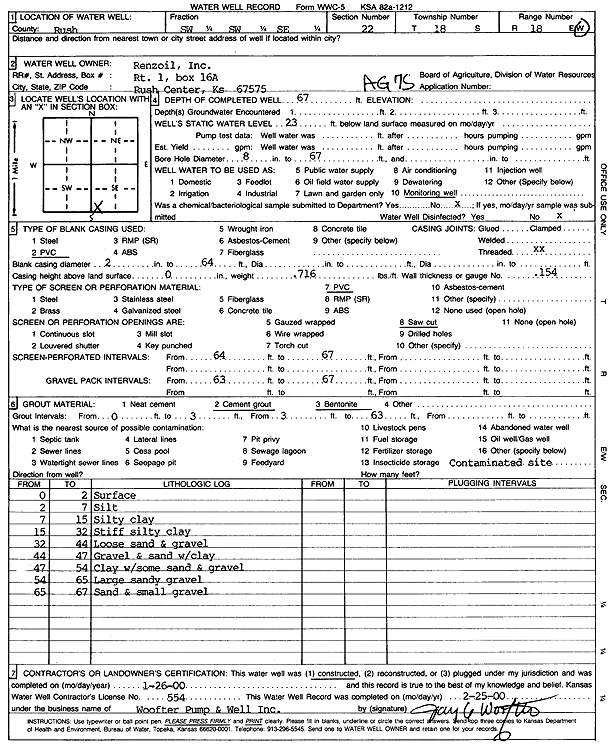
Renzoil, Inc. | 67 ft. | 23 ft. | Monitoring well/observation/piezometer | AG 7 S | Constructed | 26-Jan-2000 | Scan | |
|
T18S, R18W, Sec. 22 SW SW SE |
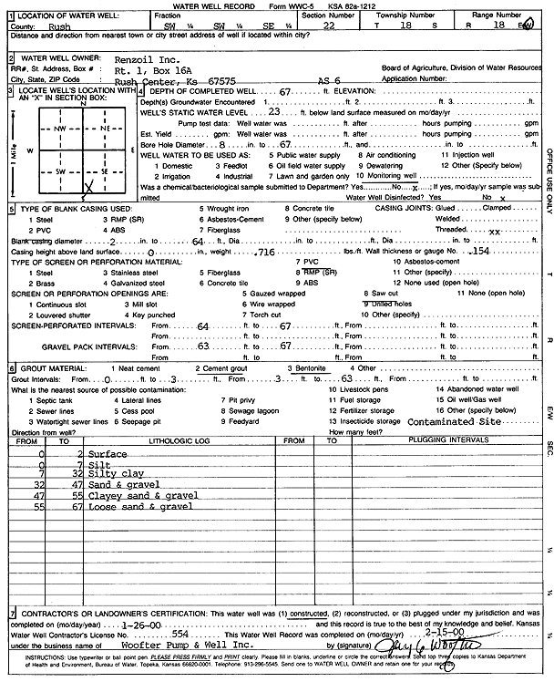
Renzoil, Inc. | 67 ft. | 23 ft. | Environmental Remediation, Air Sparge | AS 6 | Constructed | 26-Jan-2000 | Scan | |
|
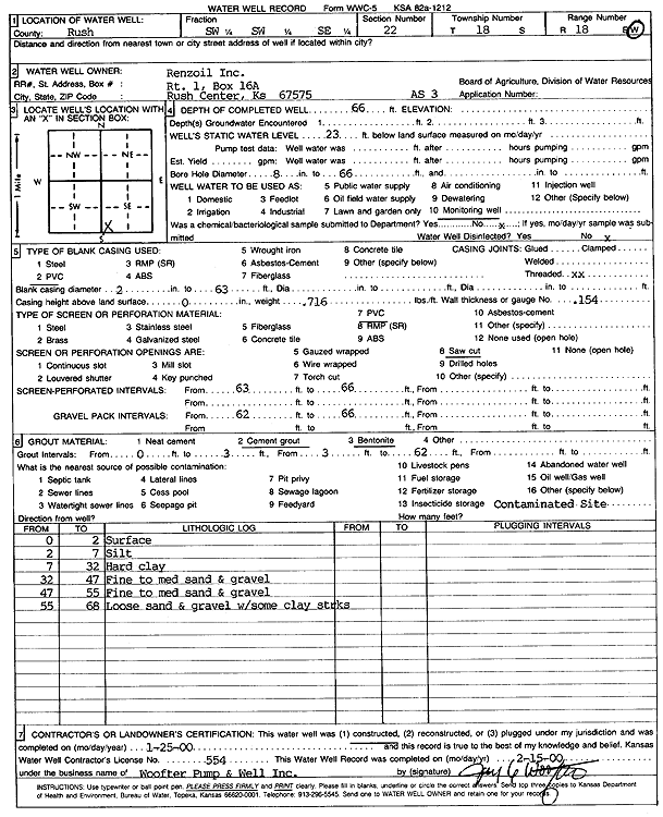
T18S, R18W, Sec. 22 SW SW SE |
Renzoil, Inc. | 66 ft. | 23 ft. | Environmental Remediation, Air Sparge | AS 3 | Constructed | 25-Jan-2000 | Scan | |
|
T18S, R18W, Sec. 22 SW SW SE |
Renzoil, Inc. | 68 ft. | 23 ft. | Environmental Remediation, Air Sparge | AS 12 | Constructed | 28-Jan-2000 | Scan | |
|
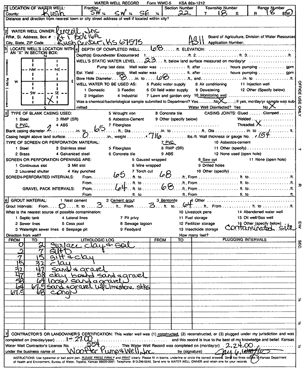
T18S, R18W, Sec. 22 SW SW SE |
Renzoil, Inc. | 68 ft. | 23 ft. | Environmental Remediation, Air Sparge | AS 11 | Constructed | 27-Jan-2000 | Scan | |
|
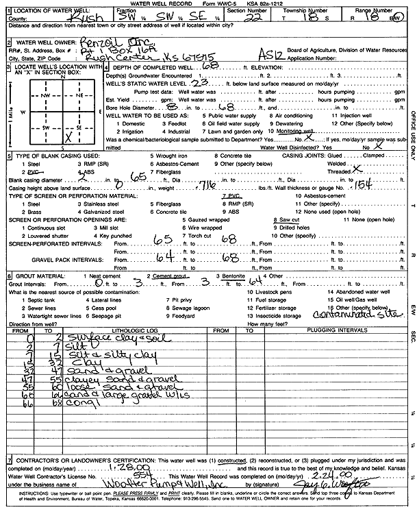
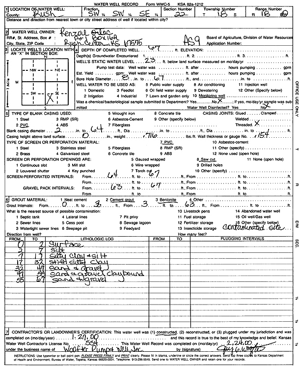
T18S, R18W, Sec. 22 SW SW SE |
Renzoil, Inc. | 67 ft. | 23 ft. | Environmental Remediation, Air Sparge | AS 9 | Constructed | 27-Jan-2000 | Scan | |
|
T18S, R18W, Sec. 22 SW SW SE |
Renzoil, Inc. | 67 ft. | 23 ft. | Environmental Remediation, Air Sparge | AS 8 | Constructed | 26-Jan-2000 | Scan | |
|
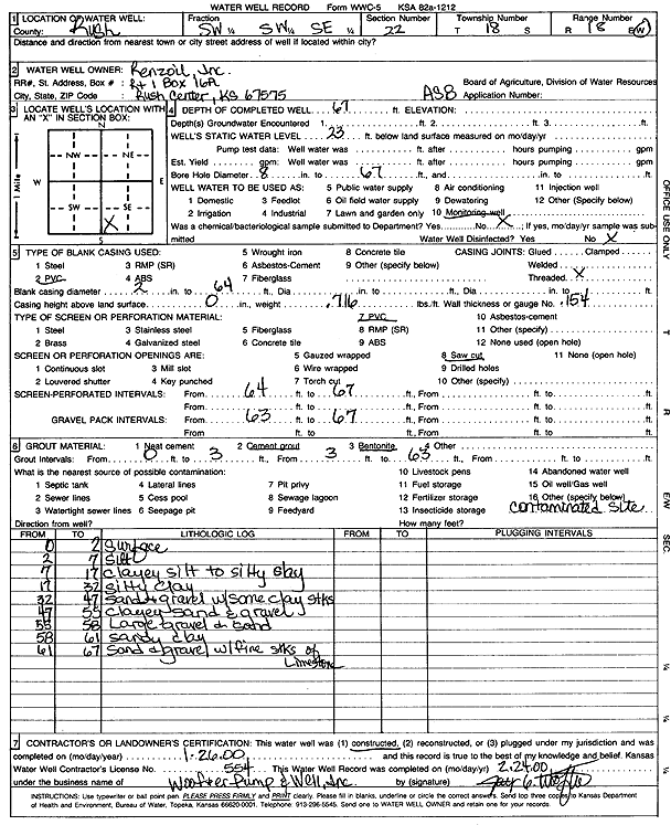
T18S, R18W, Sec. 22 SW SW SE |
Renzoil, Inc. | 68 ft. | 23 ft. | Environmental Remediation, Air Sparge | AS 14 | Constructed | 28-Jan-2000 | Scan | |
|
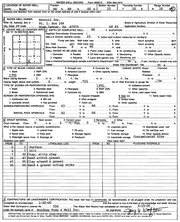
T18S, R18W, Sec. 22 SW SW SE |
Renzoil, Inc. | 66 ft. | 23 ft. | Environmental Remediation, Air Sparge | AS 1 | Constructed | 25-Jan-2000 | Scan | |
|
T18S, R18W, Sec. 22 SW SW SE |
Renzoil, Inc. | 66 ft. | 23 ft. | Environmental Remediation, Air Sparge | AS 2 | Constructed | 25-Jan-2000 | Scan | |
|
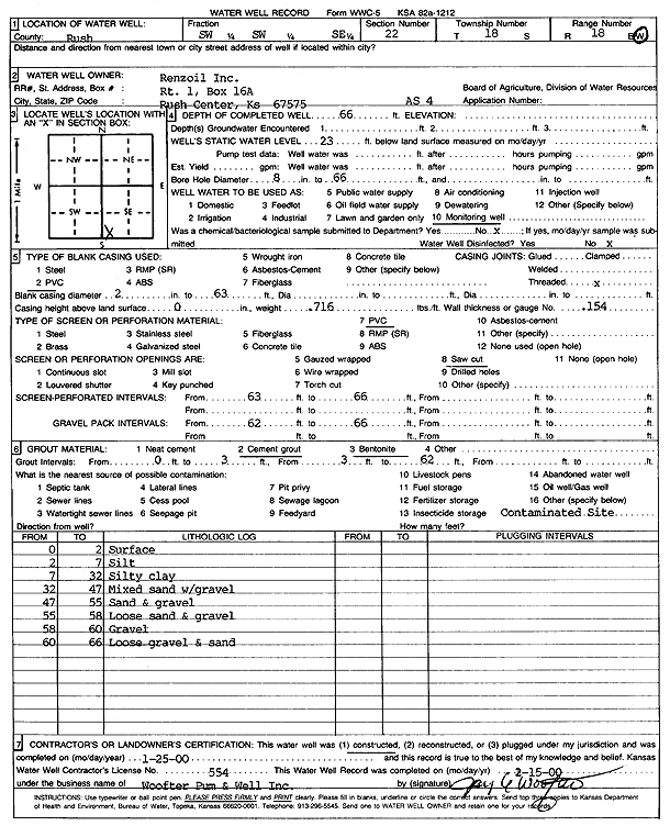
T18S, R18W, Sec. 22 SW SW SE |
Renzoil, Inc. | 66 ft. | 23 ft. | Environmental Remediation, Air Sparge | AS 4 | Constructed | 25-Jan-2000 | Scan | |
|
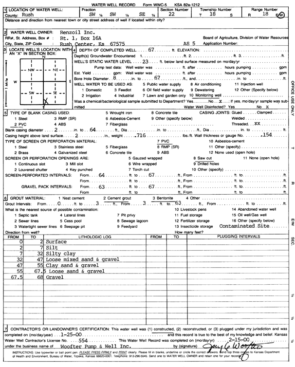
T18S, R18W, Sec. 22 SW SW SE |
Renzoil, Inc. | 67 ft. | 23 ft. | Environmental Remediation, Air Sparge | AS 5 | Constructed | 25-Jan-2000 | Scan | |
|
T18S, R18W, Sec. 22 SW SW SE |
Renzoil, Inc. | 67 ft. | 23 ft. | Environmental Remediation, Air Sparge | AS 7 | Constructed | 26-Jan-2000 | Scan | |
|
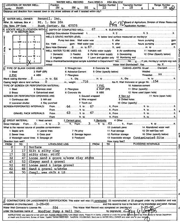
T18S, R18W, Sec. 22 SW SW SE |
Renzoil, Inc. | 67 ft. | Monitoring well/observation/piezometer | AG 7 D | Constructed | 26-Jan-2000 | Scan | ||
|
T18S, R18W, Sec. 22 NE SW SE |
Woodman and Iannitti Oil Co. | 75 ft. | 37 ft. | 60 gpm. | Oil Field Water Supply | Keener 1 | Constructed | 05-Jan-1980 | |
|
T18S, R18W, Sec. 23 NE NE SW |
B and B Drilling, Inc. | 75 ft. | 34 ft. | Oil Field Water Supply | Constructed | 26-Jul-1981 | |||
|
T18S, R18W, Sec. 23 SE SE NE |
Bahr, Patricia | 69 ft. | 39 ft. | Oil Field Water Supply | Constructed | 20-May-1988 | |||
|
T18S, R18W, Sec. 23 NW SW NW |
Rush County | 222 ft. | 60 ft. | 40 gpm. | Domestic | Constructed | 04-Mar-1997 | ||
|
T18S, R18W, Sec. 23 NE SW NW |
Rush County | 30 ft. | 4 ft. | Domestic | Plugged | 12-May-1997 | |||
|
T18S, R18W, Sec. 23 S2 SW |
Rush County Farm | 73 ft. | 30 ft. | 1000 gpm. | Irrigation | Constructed | 29-Jul-2005 | ||
|
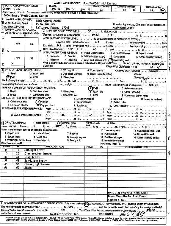
T18S, R18W, Sec. 23 SW SW SW |
Rush County Farms | 57 ft. | Monitoring well/observation/piezometer | HX 8 D | Constructed | 14-May-2002 | Scan | ||
|
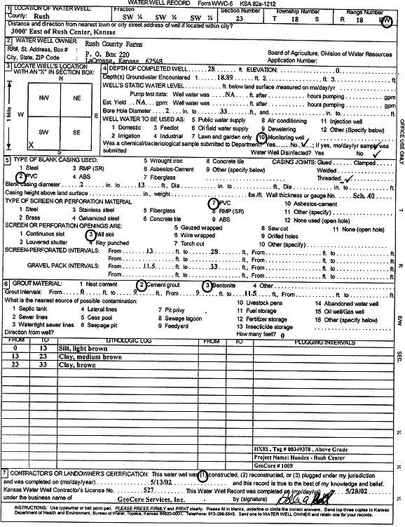
T18S, R18W, Sec. 23 SW SW SW |
Rush County Farms | 28 ft. | Monitoring well/observation/piezometer | HX 8 S | Constructed | 13-May-2002 | Scan | ||
|
T18S, R18W, Sec. 24 SW SW NW |
Haberman, Anna | 50 ft. | 33 ft. | 60 gpm. | Domestic | Constructed | 08-Mar-1988 | ||
|
T18S, R18W, Sec. 24 SW NW SW |
Haberman, Anna | 73 ft. | 37 ft. | Oil Field Water Supply | Constructed | 05-Oct-1988 | |||
|
T18S, R18W, Sec. 24 NW NW SW |
Haberman, Henry | 75 ft. | 38 ft. | 40 gpm. | Domestic, Livestock | Constructed | 26-Nov-2012 | ||
|
T18S, R18W, Sec. 24 SW SW SE |
Oborny, John | 90 ft. | 27 ft. | 1766 gpm. | Irrigation | Constructed | 15-Apr-2010 | ||
|
T18S, R18W, Sec. 24 SW SW NW |
Oborny, John | 78 ft. | 26 ft. | 983 gpm. | Irrigation | Constructed | 05-Apr-2011 | ||
|
T18S, R18W, Sec. 24 NW SW NW |
Oborny, Rudolph | 90 ft. | 43 ft. | Oil Field Water Supply | W I | Constructed | 25-Mar-1990 | ||
|
T18S, R18W, Sec. 24 SW SW NE |
Schwartzkopf, Clayton | 141 ft. | 93 ft. | 15 gpm. | Domestic, Livestock | Constructed | 19-Dec-1979 | ||
|
T18S, R18W, Sec. 24 SW SW NE |
Woodman-Iannitti Drilling Co. | 60 ft. | 33 ft. | Oil Field Water Supply | Oborny 2 | Constructed | 28-Mar-1985 | ||
|
T18S, R18W, Sec. 24 SW SE NW |
Woodman-Iannitti Drilling Co. | 70 ft. | 35 ft. | Oil Field Water Supply | Constructed | 30-Jan-1991 | |||
|
T18S, R18W, Sec. 25 SW NW SW |
Barron, T. D. | 54 ft. | 26 ft. | Irrigation | Plugged | 31-Jul-1996 | |||
|
T18S, R18W, Sec. 25 NW NE SW |
Barron, T. D. | 63 ft. | 35 ft. | Oil Field Water Supply | Constructed | 18-Feb-1988 | |||
|
T18S, R18W, Sec. 25 SW NW SW |
Barron, T. D. | 55 ft. | 27.67 ft. | 700 gpm. | Irrigation | Constructed | 08-Aug-1996 | ||
|
T18S, R18W, Sec. 25 NW NW SE |
Barron, Ted | 53 ft. | 24 ft. | Irrigation | Constructed | 17-Sep-1976 | |||
|
T18S, R18W, Sec. 25 E2 W2 SW |
Barron, Ted/Slawson Drilling | 55 ft. | 39 ft. | Oil Field Water Supply | Constructed | 26-Aug-1984 | |||
|
T18S, R18W, Sec. 25 NW SW NW |
Oborny, Frank P. | 70 ft. | 32 ft. | Irrigation | Plugged | 11-Nov-1989 | |||
|
T18S, R18W, Sec. 25 NE NW NW |
Oborny, John | 71 ft. | 33 ft. | Irrigation | Constructed | 14-Apr-1992 | |||
|
T18S, R18W, Sec. 25 SE SE |
Olverious, J. L. | 72 ft. | 32 ft. | Irrigation | Constructed | 06-Jun-1975 | |||
|
T18S, R18W, Sec. 25 SW SW |
Woodman-Iannitti Drilling Co. | 55 ft. | 37 ft. | 50 gpm. | Oil Field Water Supply | Constructed | 20-Jan-1979 | ||
|
T18S, R18W, Sec. 26 NW SW SE |
Barron, T. D. | 54 ft. | 24 ft. | 600 gpm. | Irrigation | Constructed | 24-Apr-1997 | ||
|
T18S, R18W, Sec. 26 C SE SE |
Barron, Ted | 52 ft. | 41.5 ft. | Domestic | Constructed | 31-Oct-1978 | |||
|
T18S, R18W, Sec. 26 SE SE SE |
Barron, Ted | 195 ft. | 52 ft. | 15 gpm. | Domestic, Livestock | Constructed | 02-Aug-1977 | ||
|
T18S, R18W, Sec. 26 NW SW SE |
Barron, Ted | 57 ft. | 24 ft. | Irrigation | Plugged | 16-Apr-1997 | |||
| View page: < Prev || 21 || 22 || 23 || 24 || 25 || 26 || 27 || 28 || 29 || 30 || Next > | |||||||||