Select location of well to view details.
Click on column heading to sort.
|
|
|
County: Rush Select location of well to view details. Click on column heading to sort. |
|
|
|
| View page: < Prev || 21 || 22 || 23 || 24 || 25 || 26 || 27 || 28 || 29 || 30 || Next > | |||||||||
| T-R-S | Owner | Well Depth Ascend. Desc. |
Static Water Level Ascend. Desc. |
Est. Yield Ascend. Desc. |
Well Use | Other ID | Action Taken | Completion Date Ascend. Desc. |
Scan? |
|
T18S, R19W, Sec. 17 SW NE NW |
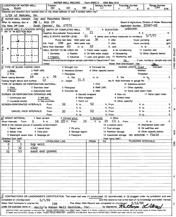
Georg, Jay and Maureen | 52 ft. | 21 ft. | 498 gpm. | Irrigation | Constructed | 07-May-1999 | Scan | |
|
T18S, R19W, Sec. 17 NE SE NW |
Kershner, Clinton and Clayton | 41 ft. | 18 ft. | 5 gpm. | Domestic, Livestock | Constructed | 28-Nov-2023 |
KOLAR |
|
|
T18S, R19W, Sec. 17 SW SE NW |
Kershner, Clinton and Clayton | 43 ft. | 17 ft. | 2 gpm. | Domestic, Livestock | Constructed | 28-Nov-2023 |
KOLAR |
|
|
T18S, R19W, Sec. 18 SW SE |
Kershner, Dwight | 53 ft. | 29.5 ft. | Irrigation | Constructed | 22-Jul-1976 | |||
|
T18S, R19W, Sec. 18 NE NW |
Kershner, Dwight | 52 ft. | 27.5 ft. | Irrigation | Constructed | 09-Apr-1975 | |||
|
T18S, R19W, Sec. 18 NW NE |
Kershner, Dwight | 51 ft. | 29.5 ft. | Domestic | Constructed | 05-Apr-1976 | |||
|
T18S, R19W, Sec. 18 NW NW |
Kershner, Dwight | 63 ft. | 27.5 ft. | Irrigation | Constructed | 07-Apr-1975 | |||
|
T18S, R19W, Sec. 19 SW SW |
Bales, Larry | 60 ft. | 30 ft. | Irrigation | Constructed | 22-Jul-1976 | |||
|
T18S, R19W, Sec. 19 NE SW |
Bales, Larry | 62 ft. | 30.5 ft. | Irrigation | Constructed | 22-Jul-1976 | |||
|
T18S, R19W, Sec. 19 NW SW SE SE |
Felder, Ruth | 55 ft. | 28 ft. | Irrigation | Plugged | 18-Apr-2020 |
KOLAR |
||
|
T18S, R19W, Sec. 19 NW SW SE SE |
Felder, Ruth | 65 ft. | 29 ft. | 783 gpm. | Irrigation | Constructed | 30-Apr-2020 |
KOLAR |
|
|
T18S, R19W, Sec. 19 SW NW NW |
Georg, Jay | 65 ft. | 30 ft. | 403 gpm. | Irrigation | Constructed | 17-Apr-2014 | ||
|
T18S, R19W, Sec. 19 NW SW NE |
Georg, Jay | 58 ft. | 32 ft. | 450 gpm. | Irrigation | Constructed | 01-Jun-1983 | ||
|
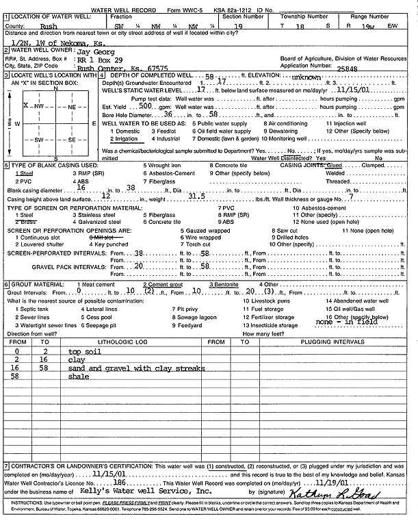
T18S, R19W, Sec. 19 SW NW NW |
Georg, Jay | 58 ft. | 17 ft. | 500 gpm. | Irrigation | Constructed | 15-Nov-2001 | Scan | |
|
T18S, R19W, Sec. 19 E2 SW NE |
Georg, Jay | 57 ft. | 23 ft. | 550 gpm. | Irrigation | Constructed | 28-Jun-1995 | ||
|
T18S, R19W, Sec. 20 NE SW SW |
Felder, Vernon | 60 ft. | 26 ft. | 765 gpm. | Irrigation | Constructed | 16-Jun-2011 | ||
|
T18S, R19W, Sec. 20 SW SE SW |
Felder, Verron | 65 ft. | Oil Field Water Supply | Constructed | 14-Oct-2008 | ||||
|
T18S, R19W, Sec. 20 SE SE NE |
Frick, Emil | 54 ft. | 20 ft. | 60 gpm. | Domestic | Constructed | 30-Nov-1993 | ||
|
T18S, R19W, Sec. 20 NW SW NW |
Keller, Lynn P. | 63 ft. | 30 ft. | Irrigation | Constructed | 01-May-1991 | |||
|
T18S, R19W, Sec. 20 NE NE NW |
Keller, Lynn P. | 56 ft. | 96 ft. | Oil Field Water Supply | Plugged | 29-Sep-2009 | |||
|
T18S, R19W, Sec. 20 NW SW NW |
Keller, Lynn P. | 63 ft. | 30 ft. | Irrigation | Plugged | 04-May-1991 | |||
|
T18S, R19W, Sec. 20 SW SW NW |
Keller, Lynn P. | 63 ft. | 30 ft. | Irrigation | Plugged | 04-May-1991 | |||
|
T18S, R19W, Sec. 20 NE NE NW |
Keller, Lynn P. | 56 ft. | Oil Field Water Supply | Constructed | 06-Dec-2008 | ||||
|
T18S, R19W, Sec. 20 NE SE NE |
North, Travis | 54 ft. | 30 ft. | 20 gpm. | Domestic | Constructed | 21-Dec-2005 | ||
|
T18S, R19W, Sec. 20 NE SE NE |
North, Travis | 38 ft. | 14 ft. | Domestic | Plugged | 15-Dec-2005 | |||
|
T18S, R19W, Sec. 20 NE NE SE |
Seltman, Bill | 54 ft. | 34 ft. | 20 gpm. | Domestic | Constructed | 18-Oct-1988 | ||
|
T18S, R19W, Sec. 21 SE SW SE |
Collins, Larry | 64 ft. | 46 ft. | Irrigation | Constructed | 25-Aug-1981 | |||
|
T18S, R19W, Sec. 21 SW SW SE |
Collins, Larry | 61 ft. | 42 ft. | 60 gpm. | Domestic | Constructed | 07-Jan-1981 | ||
|
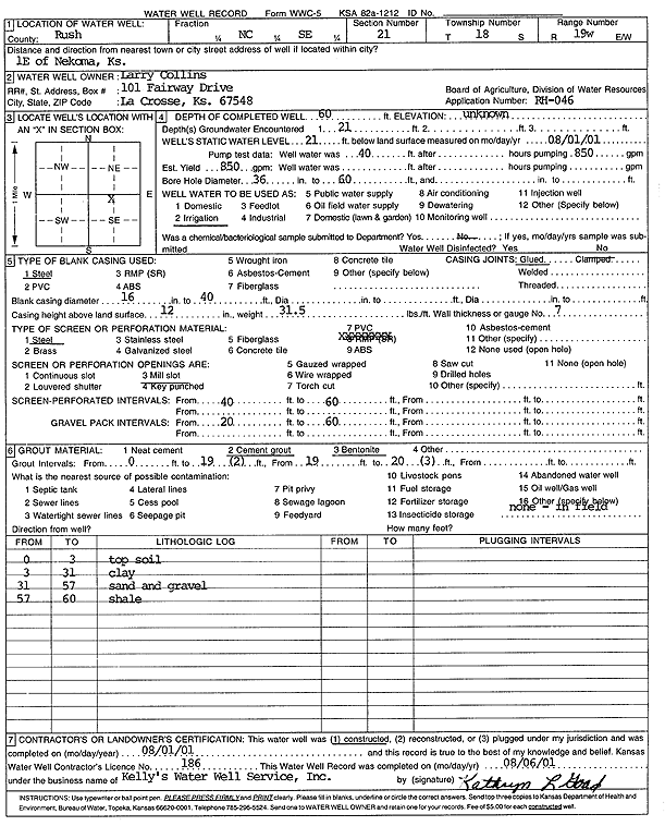
T18S, R19W, Sec. 21 SE |
Collins, Larry | 60 ft. | 21 ft. | 850 gpm. | Irrigation | Constructed | 01-Aug-2001 | Scan | |
|
T18S, R19W, Sec. 21 SE SE NW |
Keemer, George | 63 ft. | 37 ft. | 350 gpm. | Irrigation | Constructed | 11-Jul-1984 | ||
|
T18S, R19W, Sec. 21 SW SE SE |
Keener, Bill | 175 ft. | 130 ft. | 12 gpm. | Domestic, Lawn and Garden | Constructed | 13-Jun-1988 | ||
|
T18S, R19W, Sec. 21 E2 SW |
Webb, James | 61 ft. | 26 ft. | 700 gpm. | Irrigation | Constructed | 05-Jul-1996 | ||
|
T18S, R19W, Sec. 21 SW SW SE |
West, Paul | 52 ft. | 39 ft. | 15 gpm. | Domestic | Constructed | 27-Jul-1984 | ||
|
T18S, R19W, Sec. 22 NW SE NE |
Collins, John | 68 ft. | 32 ft. | 696 gpm. | Irrigation | Constructed | 29-Aug-2014 | ||
|
T18S, R19W, Sec. 22 NW NW SW |
Collins, Larry | 56 ft. | 51 ft. | 700 gpm. | Irrigation | Constructed | 30-Mar-1994 | ||
|
T18S, R19W, Sec. 22 W2 SE NE |
Ford, Everett | 66 ft. | Irrigation | Constructed | 18-Jul-1978 | ||||
|
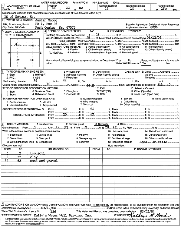
T18S, R19W, Sec. 22 SE NW NW |
Georg, Justin | 62 ft. | 25 ft. | 500 gpm. | Irrigation | Constructed | 12-Mar-2004 | Scan | |
|
T18S, R19W, Sec. 22 NW NW SW |
Kansas Dept. of Transportation, KDOT | 51 ft. | 19 ft. | Irrigation | Plugged | 01-Jul-1994 | |||
|
T18S, R19W, Sec. 22 NE SW SE |
Kershner, Bruce | 64 ft. | 36 ft. | 70 gpm. | Domestic, Livestock | Constructed | 27-Nov-2023 |
KOLAR |
|
|
T18S, R19W, Sec. 22 NW SE SE |
Kershner, Frank | 61 ft. | 35.5 ft. | 550 gpm. | Irrigation | Constructed | 13-Aug-1985 | ||
|
T18S, R19W, Sec. 22 NW SW NE |
Peach | 75 ft. | 20 ft. | 650 gpm. | Irrigation | Constructed | 05-Aug-1994 | ||
|
T18S, R19W, Sec. 22 SE NW NW |
Valley View Farms | 61 ft. | 37 ft. | 400 gpm. | Irrigation | Constructed | 21-Aug-1985 | ||
|
T18S, R19W, Sec. 23 SW SW |
John Weitzel Estate | 75 ft. | 30.67 ft. | Irrigation | Constructed | 25-Jul-1977 | |||
|
T18S, R19W, Sec. 23 SW NE NE |
Kershner, Bruce | 60 ft. | 28 ft. | 50 gpm. | Domestic, Livestock | Constructed | 21-Jul-2025 |
KOLAR |
|
|
T18S, R19W, Sec. 23 SW NW |
Pfeiffer, Jay | 56 ft. | 31.5 ft. | Domestic | Constructed | 08-Oct-1976 | |||
|
T18S, R19W, Sec. 23 SW SE SW SW |
Showalter and Sons | 64 ft. | 28.9 ft. | Irrigation | Plugged | 18-May-2018 | |||
|
T18S, R19W, Sec. 23 SW SE SW SW |
Showalter and Sons | 71.5 ft. | 29.1 ft. | Irrigation | Constructed | 08-May-2018 | |||
|
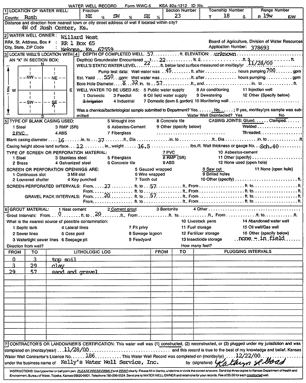
T18S, R19W, Sec. 23 NE SW SE |
West, Willard | 57 ft. | 22 ft. | 550 gpm. | Irrigation | Constructed | 28-Nov-2000 | Scan | |
|
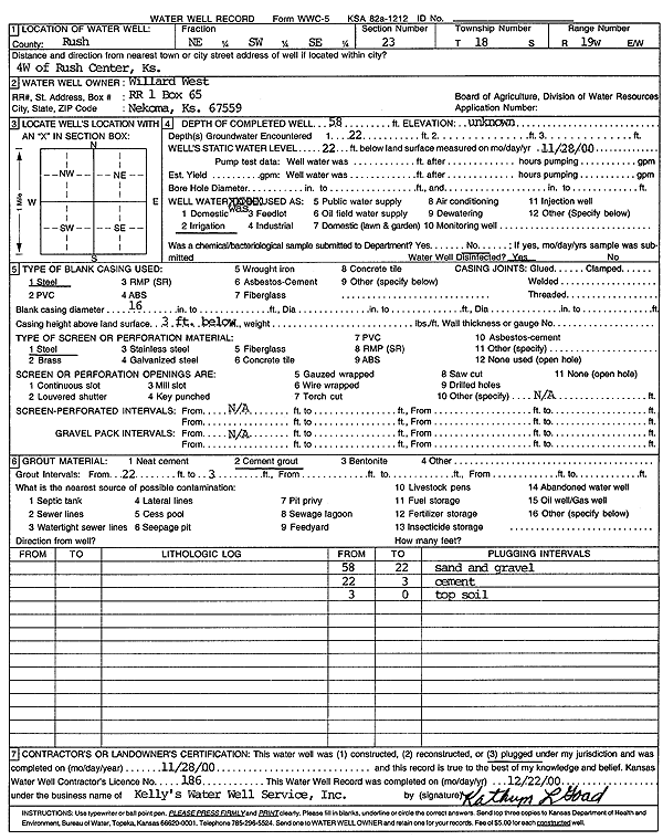
T18S, R19W, Sec. 23 NE SW SE |
West, Willard | 58 ft. | 22 ft. | Irrigation | Plugged | 28-Nov-2000 | Scan | ||
|
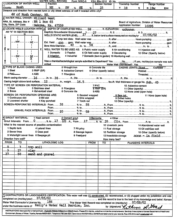
T18S, R19W, Sec. 23 NE SW SE |
West, Willard | 58 ft. | 27 ft. | 400 gpm. | Irrigation | Constructed | 05-Jul-2002 | Scan | |
| View page: < Prev || 21 || 22 || 23 || 24 || 25 || 26 || 27 || 28 || 29 || 30 || Next > | |||||||||