Select location of well to view details.
Click on column heading to sort.
|
|
|
County: Rush Select location of well to view details. Click on column heading to sort. |
|
|
|
| View page: < Prev || 31 || 32 || 33 || 34 || 35 || 36 || 37 || 38 || 39 | |||||||||
| T-R-S | Owner | Well Depth Ascend. Desc. |
Static Water Level Ascend. Desc. |
Est. Yield Ascend. Desc. |
Well Use | Other ID | Action Taken | Completion Date Ascend. Desc. |
Scan? |
|
T19S, R19W, Sec. 23 SW NW SE |
Showalter, Lee | 381 ft. | 118.6 ft. | Domestic, Livestock | Constructed | 02-Apr-2024 |
KOLAR |
||
|
T19S, R19W, Sec. 23 SW NW SE |
Showalter, Lee | 379 ft. | 95 ft. | Domestic, Livestock | Plugged | 03-Apr-2024 |
KOLAR |
||
|
T19S, R19W, Sec. 23 SW NW SE |
Showalter, Lee | 379 ft. | 246 ft. | Domestic, Livestock | Constructed | 19-Dec-2023 |
KOLAR |
||
|
T19S, R19W, Sec. 24 SE NW SE |
Colglaizer, Derrick | 365 ft. | 157 ft. | 20 gpm. | Domestic, Livestock | Constructed | 06-Mar-2024 |
KOLAR |
|
|
T19S, R19W, Sec. 24 NW SE SE |
Colglaizer, Derrick | 317 ft. | 203 ft. | 25 gpm. | Domestic | Constructed | 24-Jul-2014 | ||
|
T19S, R19W, Sec. 25 SW NW SE |
Slattery, Kenna | 231.5 ft. | 154 ft. | Domestic, Livestock | Constructed | 03-Jan-2024 |
KOLAR |
||
|
T19S, R19W, Sec. 26 NW NW NW |
Colglazer, Derrick | 392 ft. | 205 ft. | 15 gpm. | Domestic | Constructed | 24-Oct-2012 | ||
|
T19S, R19W, Sec. 26 SW SE SW |
Miller, Leland | 440 ft. | 197 ft. | Domestic, Livestock | Constructed | 05-Mar-2024 |
KOLAR |
||
|
T19S, R19W, Sec. 27 NE NE NW |
R & P Land | 340 ft. | 240 ft. | 10 gpm. | Domestic, Livestock | Constructed | 24-Mar-2025 |
KOLAR |
|
|
T19S, R19W, Sec. 28 SW SW SE |
Seltman, Mat | 380 ft. | 261 ft. | 25 gpm. | Domestic, Livestock | Constructed | 01-Jul-2024 |
KOLAR |
|
|
T19S, R19W, Sec. 33 NE SW NW |
Seltman, Brian | 400 ft. | 223 ft. | 30 gpm. | Domestic, Livestock | Constructed | 21-Jun-2024 |
KOLAR |
|
|
T19S, R19W, Sec. 35 SE SE SW |
Hagerman, Louis | 365 ft. | 240 ft. | 20 gpm. | Domestic | Constructed | 08-Aug-1975 | ||
|
T19S, R20W, Sec. 1 SW NE SE |
Seltmann, Ben | 205 ft. | 80.5 ft. | Domestic | Constructed | 28-Nov-1979 | |||
|
T19S, R20W, Sec. 2 SW SW NW |
Schlegel, Derrick | 300 ft. | 139 ft. | Domestic, Livestock | Constructed | 13-Nov-2024 |
KOLAR |
||
|
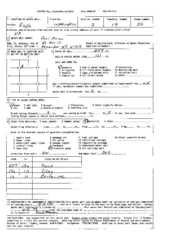
T19S, R20W, Sec. 3 NW NE |
Moran, Paul | 257 ft. | 121 ft. | Domestic | Plugged | 05-Apr-1999 | Scan | ||
|
T19S, R20W, Sec. 4 NW NE NE |
Brock Family Farm | 456 ft. | 132 ft. | Domestic, Livestock | Constructed | 12-Mar-2024 |
KOLAR |
||
|
T19S, R20W, Sec. 4 SW SW NW |
Webs, James | 355 ft. | 100 ft. | Domestic, Livestock | Constructed | 22-Feb-2024 |
KOLAR |
||
|
T19S, R20W, Sec. 4 SW NW NW |
Webs, James | 25 ft. | 20 ft. | 2.5 gpm. | Domestic | Constructed | 06-Apr-2006 | ||
|
T19S, R20W, Sec. 5 SE SE SW |
Huddleston, Alton | 335 ft. | 185 ft. | 8 gpm. | Domestic, Livestock | Constructed | 23-Aug-2013 | ||
|
T19S, R20W, Sec. 7 SE NE SW |
Schlegel, Gene | 360 ft. | 202 ft. | 12 gpm. | Domestic, Livestock | Constructed | 27-Mar-2025 |
KOLAR |
|
|
T19S, R20W, Sec. 8 SW NW NE |
Georg, John | 450 ft. | 184 ft. | 30 gpm. | Domestic, Livestock | Constructed | 04-Mar-2025 |
KOLAR |
|
|
T19S, R20W, Sec. 9 SE NW SE |
Schlegel, Gene | 445 ft. | 188 ft. | 12 gpm. | Domestic, Livestock | Constructed | 11-Apr-2025 |
KOLAR |
|
|
T19S, R20W, Sec. 10 SE SE SW |
Webs, James | 415 ft. | 78 ft. | Domestic, Livestock | Constructed | 07-Mar-2024 |
KOLAR |
||
|
T19S, R20W, Sec. 11 NW NW SW |
Webs, James | 435 ft. | 115 ft. | Domestic, Livestock | Constructed | 05-Mar-2024 |
KOLAR |
||
|
T19S, R20W, Sec. 11 C NE SE |
Wendler, Marilea | 332 ft. | 121 ft. | 50 gpm. | Domestic | Constructed | 12-Aug-1993 | ||
|
T19S, R20W, Sec. 12 NW NW NE |
Nicholson, Terri | 275 ft. | 98 ft. | Domestic, Livestock | Constructed | 08-Oct-2025 |
KOLAR |
||
|
T19S, R20W, Sec. 12 NE SE SE |
Schwindt, Rick | 430 ft. | 142 ft. | Domestic, Livestock | Constructed | 23-Apr-2025 |
KOLAR |
||
|
T19S, R20W, Sec. 12 NE NE NE |
Schwindt, Rick | 293 ft. | 103 ft. | Domestic, Livestock | Constructed | 05-Mar-2024 | KOLAR | ||
|
T19S, R20W, Sec. 13 NE NE |
Brown, Rebecca | 50 ft. | 25 ft. | 7 gpm. | Domestic, Livestock | Constructed | 13-Sep-2018 | ||
|
T19S, R20W, Sec. 13 SE NE NE |
Seltman, Mat | 440 ft. | 143 ft. | 50 gpm. | Domestic, Livestock | Constructed | 14-Aug-2024 |
KOLAR |
|
|
T19S, R20W, Sec. 13 SW NE NW |
Showalter and Sons | 312.5 ft. | 124 ft. | Domestic, Livestock | Constructed | 05-Mar-2024 | KOLAR | ||
|
T19S, R20W, Sec. 14 NW NW NW |
Wet Walnut Watershed | 15 ft. | 9 ft. | Domestic | Plugged | 30-May-1991 | |||
|
T19S, R20W, Sec. 15 NE NW SW |
Bannister Family Trust | 435 ft. | 300 ft. | Domestic, Livestock | Constructed | 16-Nov-2023 |
KOLAR |
||
|
T19S, R20W, Sec. 16 NW SE SW |
Bruntz Bros | 33 ft. | 11 ft. | 8 gpm. | Domestic | Constructed | 09-Nov-1988 | ||
|
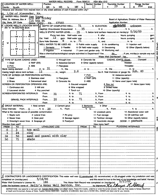
T19S, R20W, Sec. 17 NE NE NW |
Young, Sam | 71 ft. | 35 ft. | 12 gpm. | Domestic | Constructed | 16-May-2000 | Scan | |
|
T19S, R20W, Sec. 18 NW NW NW |
Schlegal, Dutch | 343 ft. | 200 ft. | 40 gpm. | Domestic | Constructed | 22-Sep-1979 | ||
|
T19S, R20W, Sec. 19 SW SW NW |
Schlegel, Gene | 500 ft. | 255 ft. | 20 gpm. | Domestic, Livestock | Constructed | 26-Nov-2024 |
KOLAR |
|
|
T19S, R20W, Sec. 21 NE NE NE |
Bannister Family Trust | 380 ft. | 140 ft. | Domestic, Livestock | Constructed | 20-Dec-2023 |
KOLAR |
||
|
T19S, R20W, Sec. 22 SE NW SW |
Bannister Family Trust | 500 ft. | 168 ft. | Domestic, Livestock | Constructed | 18-Dec-2023 |
KOLAR |
||
|
T19S, R20W, Sec. 22 NE SE NE |
Price Flying U Ltd | 365.5 ft. | 175 ft. | Domestic, Livestock | Constructed | 01-Mar-2024 |
KOLAR |
||
|
T19S, R20W, Sec. 23 NE NE SE |
Cupp, Jay | 38 ft. | 20 ft. | 3 gpm. | Domestic, Livestock | Constructed | 20-Sep-2018 | ||
|
T19S, R20W, Sec. 23 SE NE SE |
Morss Ag | 295 ft. | 155 ft. | 10 gpm. | Domestic, Livestock | Constructed | 25-Nov-2024 |
KOLAR |
|
|
T19S, R20W, Sec. 23 NW SE NE |
R and P Land | 400 ft. | 173 ft. | Domestic, Livestock | Plugged | 30-Oct-2024 |
KOLAR |
||
|
T19S, R20W, Sec. 23 NE SW NE |
R and P Land | 360 ft. | 307 ft. | 6 gpm. | Domestic, Livestock | Constructed | 22-Aug-2024 |
KOLAR |
|
|
T19S, R20W, Sec. 23 NW NE NE |
Seltman, Brian | 460 ft. | 223 ft. | 30 gpm. | Domestic, Livestock | Constructed | 30-Apr-2026 |
KOLAR |
|
|
T19S, R20W, Sec. 24 SW SW SW |
Seltman, Elmer | 290 ft. | 140 ft. | 40 gpm. | Domestic | Constructed | 21-Jul-1979 | ||
|
T19S, R20W, Sec. 24 SE NE NE |
Seltman, Terry | 360 ft. | 310 ft. | 6 gpm. | Domestic, Livestock | Constructed | 17-Jun-2024 |
KOLAR |
|
|
T19S, R20W, Sec. 24 NW SW SW |
Seltman, Terry | 280 ft. | 146 ft. | 20 gpm. | Domestic, Livestock | Constructed | 14-Jun-2024 |
KOLAR |
|
|
T19S, R20W, Sec. 25 SE SW NW |
Seltman, Bill | 295 ft. | 202 ft. | 20 gpm. | Domestic, Livestock | Constructed | 28-Feb-2025 |
KOLAR |
|
|
T19S, R20W, Sec. 26 SW NE NW |
Broin, Mark | 300 ft. | 200 ft. | Domestic, Livestock | Constructed | 06-Nov-2018 | |||
| View page: < Prev || 31 || 32 || 33 || 34 || 35 || 36 || 37 || 38 || 39 | |||||||||