Select location of well to view details.
Click on column heading to sort.
|
|
|
County: Russell Select location of well to view details. Click on column heading to sort. |
|
|
|
| View page: < Prev || 21 || 22 || 23 || 24 || 25 || 26 || 27 || 28 || 29 || 30 || Next > | |||||||||
| T-R-S | Owner | Well Depth Ascend. Desc. |
Static Water Level Ascend. Desc. |
Est. Yield Ascend. Desc. |
Well Use | Other ID | Action Taken | Completion Date Ascend. Desc. |
Scan? |
|
T13S, R15W, Sec. 31 C |
City of Gorham | 46 ft. | 6 ft. | Domestic | Plugged | 24-Feb-2008 | |||
|
T13S, R15W, Sec. 31 NW NE NE |
Cockrell, Charlie | 40 ft. | 15 ft. | 4 gpm. | Domestic, Lawn and Garden | Constructed | 13-Sep-2004 | ||
|
T13S, R15W, Sec. 31 NW NE NE |
Cockrell, Charlie | 40 ft. | 16 ft. | 10 gpm. | Domestic, Lawn and Garden | Constructed | 08-Oct-2004 | ||
|
T13S, R15W, Sec. 31 NW NW NW |
Freeman, Heidi | 10 ft. | Domestic | Plugged | 01-Jun-2010 | ||||
|
T13S, R15W, Sec. 31 NW NW SE |
Munk, Charles | 23 ft. | 15 ft. | Domestic, Lawn and Garden | Plugged | 14-Jul-1997 | |||
|
T13S, R15W, Sec. 31 NW NW SE |
Munk, Charles | 40 ft. | 15 ft. | 20 gpm. | Domestic, Lawn and Garden | Constructed | 14-Jul-1997 | ||
|
T13S, R15W, Sec. 31 NE NE SE |
Murphy, Mike | 35 ft. | 16 ft. | 15 gpm. | Domestic, Lawn and Garden | Constructed | 27-Aug-2010 | ||
|
T13S, R15W, Sec. 31 NE NE SE |
Smith, Don | 32 ft. | 14 ft. | 10 gpm. | Domestic | Constructed | 17-Nov-1994 | ||
|
T13S, R15W, Sec. 31 NE SE NE |
Weigel Oil | 20 ft. | 7.42 ft. | Monitoring well/observation/piezometer | MW 11 | Constructed | 02-Apr-1998 | ||
|
T13S, R15W, Sec. 32 NW SW NE |
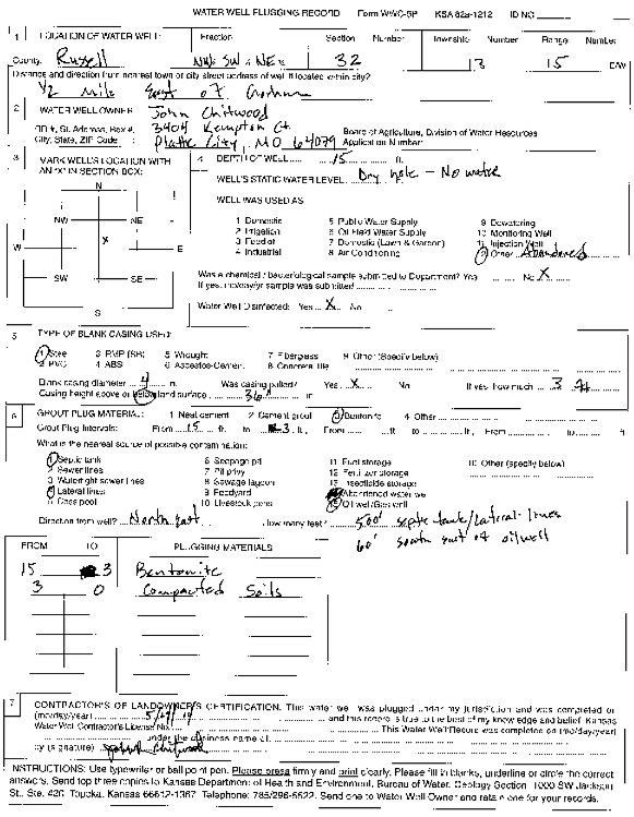
Chitwood, John | 15 ft. | (unstated)/abandoned | Plugged | 14-May-2004 | Scan | |||
|
T13S, R15W, Sec. 32 NW SW NE |
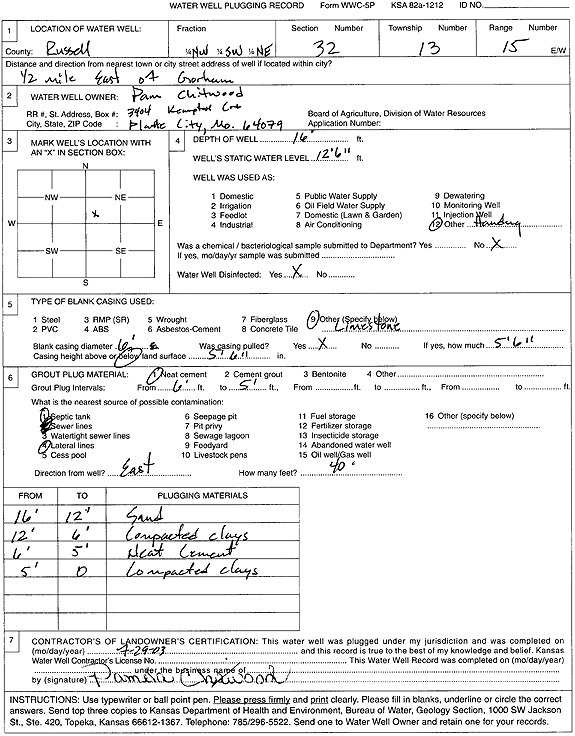
Chitwood, Pam | 16 ft. | 12.6 ft. | (unstated)/abandoned | Plugged | 29-Jul-2003 | Scan | ||
|
T13S, R15W, Sec. 32 NW SW NW |
City of Gorham | 39.5 ft. | 24 ft. | Public Water Supply | Well 4 | Plugged | 22-Oct-1987 | ||
|
T13S, R15W, Sec. 32 NW SW NW |
Dortland, Elmer | 26 ft. | 13.9 ft. | Monitoring well/observation/piezometer | MW 3 | Constructed | 15-Apr-1994 | ||
|
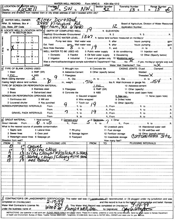
T13S, R15W, Sec. 32 SW SW NW |
Dortland, Elmer | 19 ft. | 13.67 ft. | Monitoring well/observation/piezometer | 12 | Constructed | 17-Feb-1999 | Scan | |
|
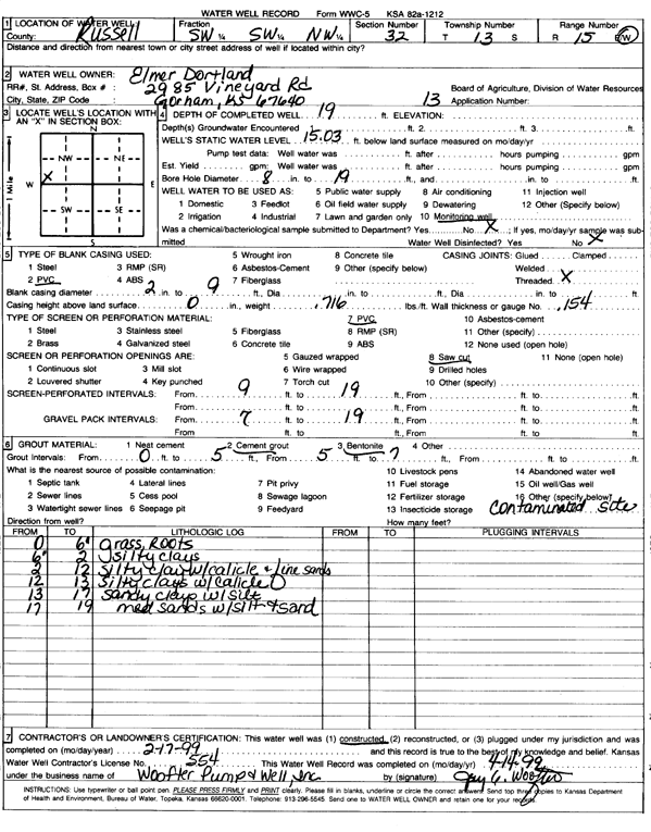
T13S, R15W, Sec. 32 SW SW NW |
Dortland, Elmer | 19 ft. | 15.03 ft. | Monitoring well/observation/piezometer | 13 | Constructed | 17-Feb-1999 | Scan | |
|
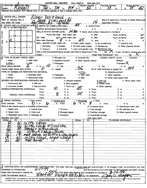
T13S, R15W, Sec. 32 SW SW NW |
Dortland, Elmer | 25 ft. | 14.86 ft. | Monitoring well/observation/piezometer | 14 | Constructed | 17-Feb-1999 | Scan | |
|
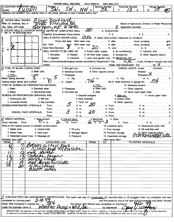
T13S, R15W, Sec. 32 SW SW NW |
Dortland, Elmer | 20 ft. | 13.52 ft. | Monitoring well/observation/piezometer | 2 | Constructed | 18-Feb-1999 | Scan | |
|
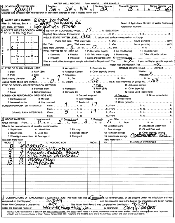
T13S, R15W, Sec. 32 SW SW NW |
Dortland, Elmer | 17 ft. | 13.85 ft. | Monitoring well/observation/piezometer | Constructed | 18-Feb-1999 | Scan | ||
|
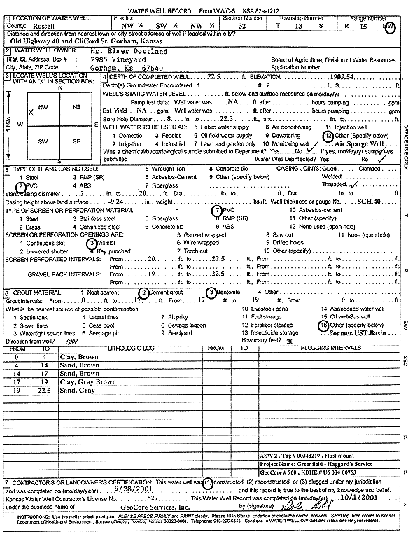
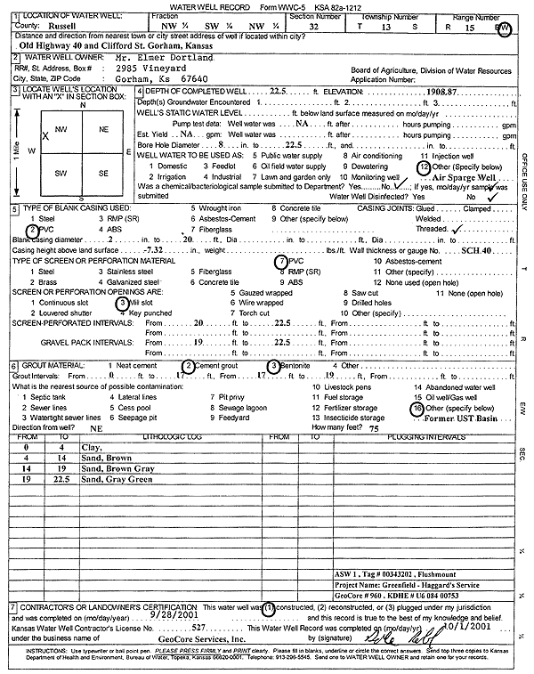
T13S, R15W, Sec. 32 NW SW NW |
Dortland, Elmer | 22.5 ft. | Environmental Remediation, Air Sparge | ASW 2 | Constructed | 28-Sep-2001 | Scan | ||
|
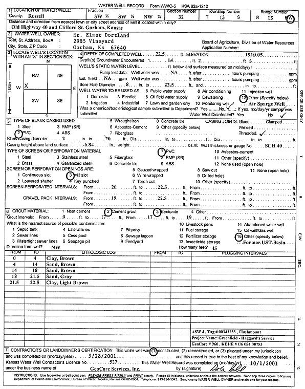
T13S, R15W, Sec. 32 SW SW NW |
Dortland, Elmer | 22.5 ft. | Environmental Remediation, Air Sparge | ASW 4 | Constructed | 28-Sep-2001 | Scan | ||
|
T13S, R15W, Sec. 32 SW SW NW |
Dortland, Elmer | 22.5 ft. | Environmental Remediation, Air Sparge | ASW 5 | Constructed | 28-Sep-2001 | Scan | ||
|
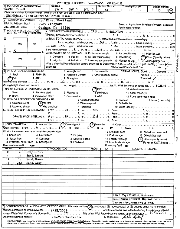
T13S, R15W, Sec. 32 SW SW NW |
Dortland, Elmer | 22.5 ft. | Environmental Remediation, Air Sparge | ASW 6 | Constructed | 28-Sep-2001 | Scan | ||
|
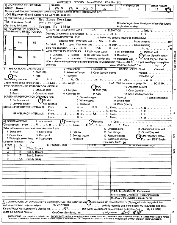
T13S, R15W, Sec. 32 SW SW NW |
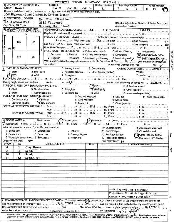
Dortland, Elmer | 18.5 ft. | Environmental Remediation, Soil Vapor Extraction | SVE 2 | Constructed | 28-Sep-2001 | Scan | ||
|
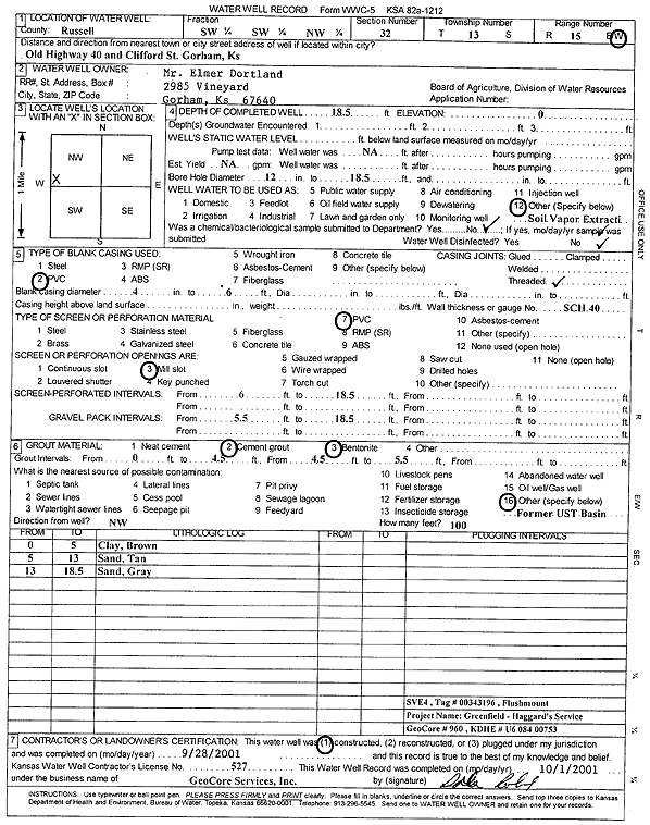
T13S, R15W, Sec. 32 SW SW NW |
Dortland, Elmer | 18.5 ft. | Environmental Remediation, Soil Vapor Extraction | SVE 4 | Constructed | 28-Sep-2001 | Scan | ||
|
T13S, R15W, Sec. 32 SW SW NW |
Dortland, Elmer | 18.5 ft. | Environmental Remediation, Soil Vapor Extraction | SVE 1 | Constructed | 28-Sep-2001 | Scan | ||
|
T13S, R15W, Sec. 32 NW SW NW |
Dortland, Elmer | 27 ft. | 14.9 ft. | Monitoring well/observation/piezometer | MW 5 | Constructed | 15-Apr-1994 | ||
|
T13S, R15W, Sec. 32 NW SW NW |
Dortland, Elmer | 27 ft. | 13.65 ft. | Monitoring well/observation/piezometer | MW 6 | Constructed | 15-Apr-1994 | ||
|
T13S, R15W, Sec. 32 SW SW NW |
Dortland, Elmer | 18.5 ft. | Environmental Remediation, Soil Vapor Extraction | SVE 3 | Constructed | 28-Sep-2001 | Scan | ||
|
T13S, R15W, Sec. 32 NW SW NW |
Dortland, Elmer | 22.5 ft. | Environmental Remediation, Air Sparge | ASW 1 | Constructed | 28-Sep-2001 | Scan | ||
|
T13S, R15W, Sec. 32 SW SW NW |
Dortland, Elmer | 22.5 ft. | Environmental Remediation, Air Sparge | ASW 3 | Constructed | 28-Sep-2001 | Scan | ||
|
T13S, R15W, Sec. 32 NW SW NW |
Dortland, Elmer | 26 ft. | 14.9 ft. | Monitoring well/observation/piezometer | MW 2 | Constructed | 15-Apr-1994 | ||
|
T13S, R15W, Sec. 32 NW SW NW |
Dortland, Elmer | 22 ft. | 14.3 ft. | Monitoring well/observation/piezometer | MW 8 | Constructed | 21-Apr-1994 | ||
|
T13S, R15W, Sec. 32 NW SW NW |
Dortland, Elmer | 22 ft. | 11.7 ft. | Monitoring well/observation/piezometer | MW 10 | Constructed | 21-Apr-1994 | ||
|
T13S, R15W, Sec. 32 NW SW NW |
Dortland, Elmer | 29 ft. | 14.76 ft. | Monitoring well/observation/piezometer | MW 1 | Constructed | 15-Apr-1994 | ||
|
T13S, R15W, Sec. 32 NW SW NW |
Dortland, Elmer | 22 ft. | 12.3 ft. | Monitoring well/observation/piezometer | MW 11 | Constructed | 21-Apr-1994 | ||
|
T13S, R15W, Sec. 32 NW SW NW |
Dortland, Elmer | 22 ft. | 12.6 ft. | Monitoring well/observation/piezometer | MW 9 | Constructed | 21-Apr-1994 | ||
|
T13S, R15W, Sec. 32 NW SW NW |
Dortland, Elmer | 27 ft. | 12.4 ft. | Monitoring well/observation/piezometer | MW 7 | Constructed | 15-Apr-1994 | ||
|
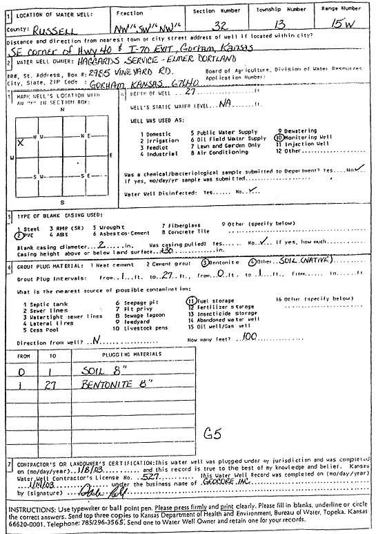
T13S, R15W, Sec. 32 NW SW NW |
Dortland, Elmer | 27 ft. | Monitoring well/observation/piezometer | G 5 | Plugged | 08-Jan-2003 | Scan | ||
|
T13S, R15W, Sec. 32 NW SW NW |
Dortland, Elmer | 26 ft. | Monitoring well/observation/piezometer | G 2 | Plugged | 09-Jan-2003 | Scan | ||
|
T13S, R15W, Sec. 32 SW SW NW |
Haggard's Service | 18.5 ft. | Environmental Remediation, Soil Vapor Extraction | SVE 2 | Plugged | 21-Jun-2016 | |||
|
T13S, R15W, Sec. 32 NW SW NW |
Haggard's Service | 17 ft. | Environmental Remediation, Soil Vapor Extraction | VEW 2 | Plugged | 21-Jun-2016 | |||
|
T13S, R15W, Sec. 32 NW SW NW |
Haggard's Service | 20 ft. | Monitoring well/observation/piezometer | VOBW 2 | Plugged | 21-Jun-2016 | |||
|
T13S, R15W, Sec. 32 SW SW NW |
Haggard's Service | 18.5 ft. | Environmental Remediation, Soil Vapor Extraction | SVE 4 | Plugged | 21-Jun-2016 | |||
|
T13S, R15W, Sec. 32 SW SW NW |
Haggard's Service | 22.5 ft. | Environmental Remediation, Air Sparge | AS 3 | Plugged | 21-Jun-2016 | |||
|
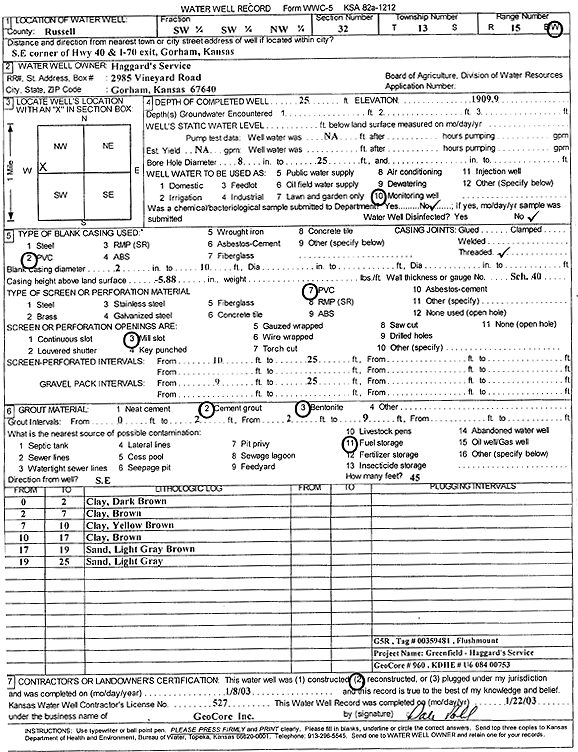
T13S, R15W, Sec. 32 SW SW NW |
Haggard's Service | 25 ft. | Monitoring well/observation/piezometer | G 5 R | Reconstructed | 08-Jan-2003 | Scan | ||
|
T13S, R15W, Sec. 32 SW SW NW |
Haggard's Service | 22.5 ft. | Environmental Remediation, Air Sparge | AS 4 | Plugged | 21-Jun-2016 | |||
|
T13S, R15W, Sec. 32 SW SW NW |
Haggard's Service | 18.5 ft. | Environmental Remediation, Soil Vapor Extraction | SVE 3 | Plugged | 21-Jun-2016 | |||
|
T13S, R15W, Sec. 32 NW SW SW |
Haggard's Service | 27 ft. | Monitoring well/observation/piezometer | G 6 | Plugged | 06-Jun-2013 | |||
|
T13S, R15W, Sec. 32 SW SW NW |
Haggard's Service | 18.5 ft. | Environmental Remediation, Soil Vapor Extraction | SVE 1 | Plugged | 21-Jun-2016 | |||
|
T13S, R15W, Sec. 32 SW SW NW |
Haggard's Service | 22.5 ft. | Environmental Remediation, Air Sparge | AS 6 | Plugged | 21-Jun-2016 | |||
| View page: < Prev || 21 || 22 || 23 || 24 || 25 || 26 || 27 || 28 || 29 || 30 || Next > | |||||||||