Select location of well to view details.
Click on column heading to sort.
|
|
|
County: Russell Select location of well to view details. Click on column heading to sort. |
|
|
|
| View page: < Prev || 21 || 22 || 23 || 24 || 25 || 26 || 27 || 28 || 29 || 30 || Next > | |||||||||
| T-R-S | Owner | Well Depth Ascend. Desc. |
Static Water Level Ascend. Desc. |
Est. Yield Ascend. Desc. |
Well Use | Other ID | Action Taken | Completion Date Ascend. Desc. |
Scan? |
|
T14S, R14W, Sec. 3 NW NW NW |
New Oil Company of Kansas Inc. | 13 ft. | 5.61 ft. | Monitoring well/observation/piezometer | MW 6 | Constructed | 06-Aug-1998 | ||
|
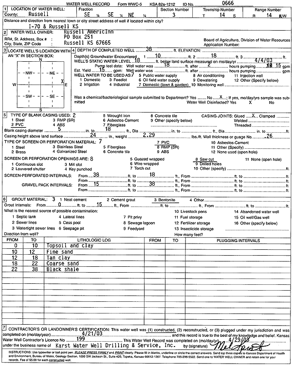
T14S, R14W, Sec. 3 SE SE NE |
Russell AmericInn | 38 ft. | 18 ft. | 15 gpm. | Domestic, Lawn and Garden | Constructed | 21-Apr-2003 | Scan | |
|
T14S, R14W, Sec. 3 SE SE NW |
Thouvenelle, Gerald J. | 34.6 ft. | 23 ft. | Domestic, Lawn and Garden | Constructed | 07-Jul-1990 | |||
|
T14S, R14W, Sec. 3 SW NE NE |
Thyfault, Terry | 43 ft. | 25 ft. | Domestic, Lawn and Garden | Constructed | 15-Jun-1990 | Scan | ||
|
T14S, R14W, Sec. 4 SE SE SE |
Krug, Mollie R. | 18 ft. | 17 ft. | Domestic | Plugged | 06-Apr-1990 | |||
|
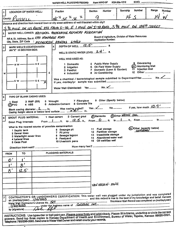
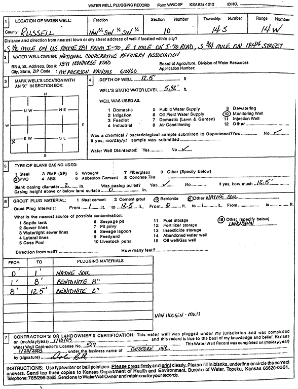
T14S, R14W, Sec. 9 NE SE SE |
National Cooperative Refinery Assoc. | 12.5 ft. | 2.4 ft. | Monitoring well/observation/piezometer | MW 2 | Plugged | 10-Jan-2003 | Scan | |
|
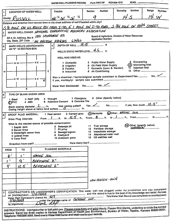
T14S, R14W, Sec. 9 NE SE SE |
National Cooperative Refinery Assoc. | 12.5 ft. | 4.6 ft. | Monitoring well/observation/piezometer | MW 4 | Plugged | 10-Jan-2003 | Scan | |
|
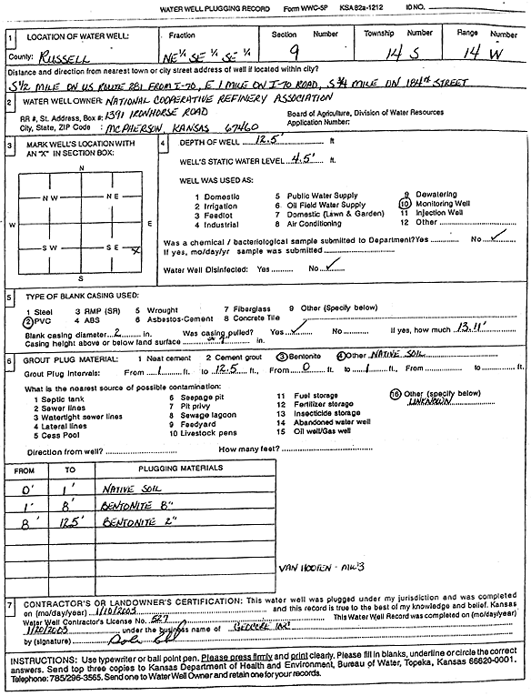
T14S, R14W, Sec. 9 NE SE SE |
National Cooperative Refinery Assoc. | 12.5 ft. | 4.5 ft. | Monitoring well/observation/piezometer | MW 3 | Plugged | 10-Jan-2003 | Scan | |
|
T14S, R14W, Sec. 10 NW |
Kaw Pipeline | 12 ft. | 10 ft. | Monitoring well/observation/piezometer | MW 1 | Constructed | 20-Oct-2000 | Scan | |
|
T14S, R14W, Sec. 10 NW |
Kaw Pipeline | 12 ft. | 10 ft. | Monitoring well/observation/piezometer | MW 3 | Constructed | 02-Oct-2000 | Scan | |
|
T14S, R14W, Sec. 10 NW |
Kaw Pipeline | 12 ft. | 10 ft. | Monitoring well/observation/piezometer | MW 2 | Constructed | 21-Oct-2000 | Scan | |
|
T14S, R14W, Sec. 10 NW SW SW |
National Cooperative Refinery Assoc. | 12.5 ft. | 5.92 ft. | Monitoring well/observation/piezometer | MW 1 | Plugged | 10-Jan-2003 | Scan | |
|
T14S, R14W, Sec. 21 SW |
Becker, Wesley | 141 ft. | 130 ft. | 2 gpm. | Domestic, Livestock | Constructed | 12-Nov-1979 | ||
|
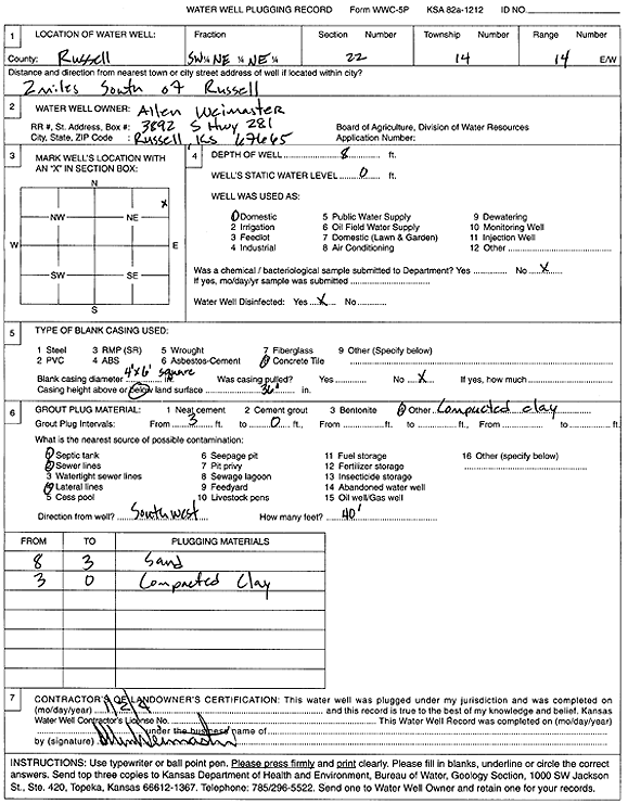
T14S, R14W, Sec. 22 SW NE NE |
Weimaster, Allen | 8 ft. | Domestic | Plugged | 02-Jan-2004 | Scan | |||
|
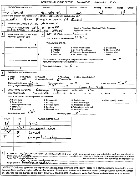
T14S, R14W, Sec. 22 SE NE NE |
Weimaster, Allen | 21 ft. | 20.6 ft. | Domestic, Lawn and Garden | Plugged | 02-Jan-2004 | Scan | ||
|
T14S, R14W, Sec. 24 NE NE NE |
Engle, Don | 85 ft. | 42 ft. | 5.5 gpm. | Domestic | Constructed | 25-Sep-1995 | ||
|
T14S, R14W, Sec. 25 C NW NW |
Hallwood Petroleum, Inc. | 111 ft. | 86 ft. | Oil Field Water Supply | Plugged | 12-Dec-1996 | |||
|
T14S, R14W, Sec. 29 NE NW SW |
Ehrlich, Roland | 69 ft. | 30 ft. | 4 gpm. | Domestic, Livestock | Constructed | 19-Jul-1998 | ||
|
T14S, R14W, Sec. 29 SW SW SE |
Schoenberger, James | 56 ft. | 30 ft. | 15 gpm. | Domestic, Livestock | Constructed | 01-Apr-2014 | ||
|
T14S, R14W, Sec. 30 NE SE SE |
Ceule, Jerry | 32 ft. | 18 ft. | 10 gpm. | Domestic, Livestock | Constructed | 19-Sep-2015 | ||
|
T14S, R14W, Sec. 30 SW NE NW |
Hummel Sr., J. W. | 73 ft. | 60 ft. | 10 gpm. | Domestic, Livestock | Constructed | 17-Dec-1978 | ||
|
T14S, R14W, Sec. 30 NW NE NE |
Schoenberger, James | 31 ft. | Domestic, Lawn and Garden | Plugged | 23-May-2013 | ||||
|
T14S, R14W, Sec. 30 NE NE NE |
Schoenberger, James | 118 ft. | 74 ft. | 5 gpm. | Domestic, Livestock | Constructed | 22-May-2013 | ||
|
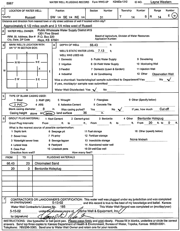
T14S, R14W, Sec. 31 SW SE NE |
Public Wholesale Water Supply District 15 | 66.43 ft. | 7.13 ft. | Monitoring well/observation/piezometer | Layne Western | Plugged | 13-May-2002 | Scan | |
|
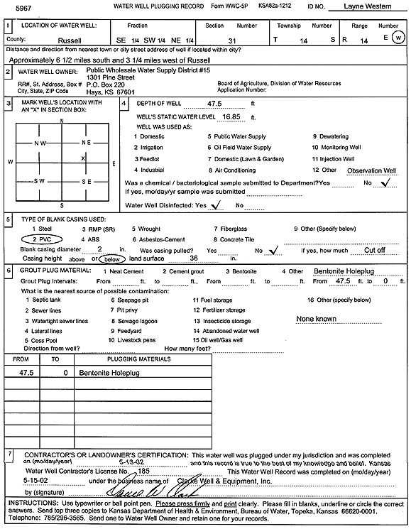
T14S, R14W, Sec. 31 SE SW NE |
Public Wholesale Water Supply District 15 | 47.5 ft. | 16.85 ft. | Monitoring well/observation/piezometer | Layne Western | Plugged | 13-May-2002 | Scan | |
|
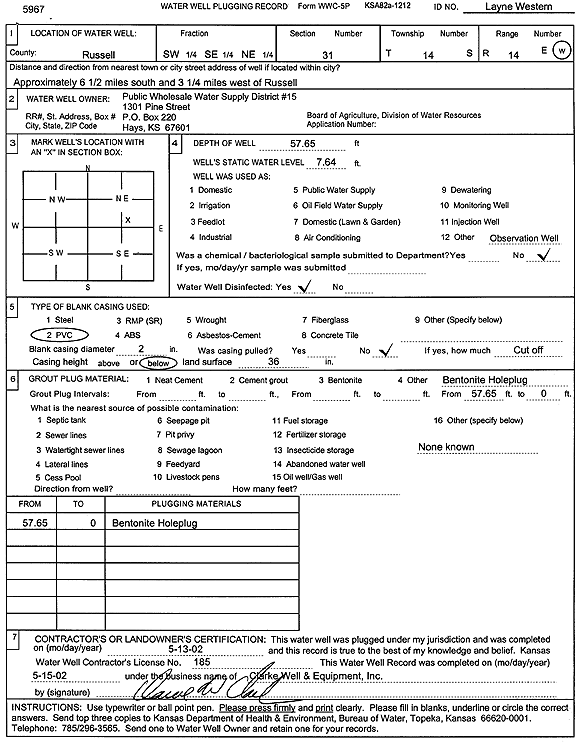
T14S, R14W, Sec. 31 SW SE NE |
Public Wholesale Water Supply District 15 | 57.65 ft. | 7.64 ft. | Monitoring well/observation/piezometer | Layne Western | Plugged | 13-May-2002 | Scan | |
|
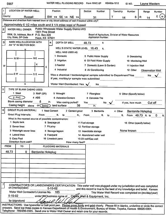
T14S, R14W, Sec. 31 SW SE NE |
Public Wholesale Water Supply District 15 | 48.73 ft. | 16.43 ft. | Monitoring well/observation/piezometer | Layne Western | Plugged | 13-May-2002 | Scan | |
|
T14S, R14W, Sec. 32 NE NE NE |
Schoenberger, James | 56 ft. | 20 ft. | 30 gpm. | Domestic, Livestock | Constructed | 11-Apr-2014 | ||
|
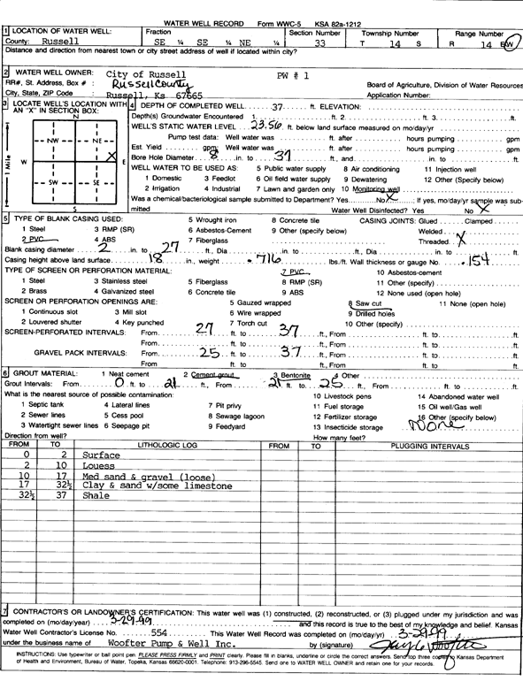
T14S, R14W, Sec. 33 SE SE NE |
City of Russell | 37 ft. | 23.56 ft. | Monitoring well/observation/piezometer | PW 1 | Constructed | 29-Mar-1999 | Scan | |
|
T14S, R14W, Sec. 33 NE SE SW |
Morganstein, Jim | 105 ft. | 75 ft. | 5 gpm. | Domestic, Lawn and Garden | Constructed | 23-Jan-2006 | ||
|
T14S, R14W, Sec. 33 NE SE SW |
Morganstein, Jim | 90 ft. | 75 ft. | 4 gpm. | Domestic, Lawn and Garden | Constructed | 23-Jan-2006 | ||
|
T14S, R14W, Sec. 33 SE SE NE |
Nye, Jason | 65 ft. | 25 ft. | 20 gpm. | Domestic, Livestock | Constructed | 05-Jun-2023 |
KOLAR |
|
|
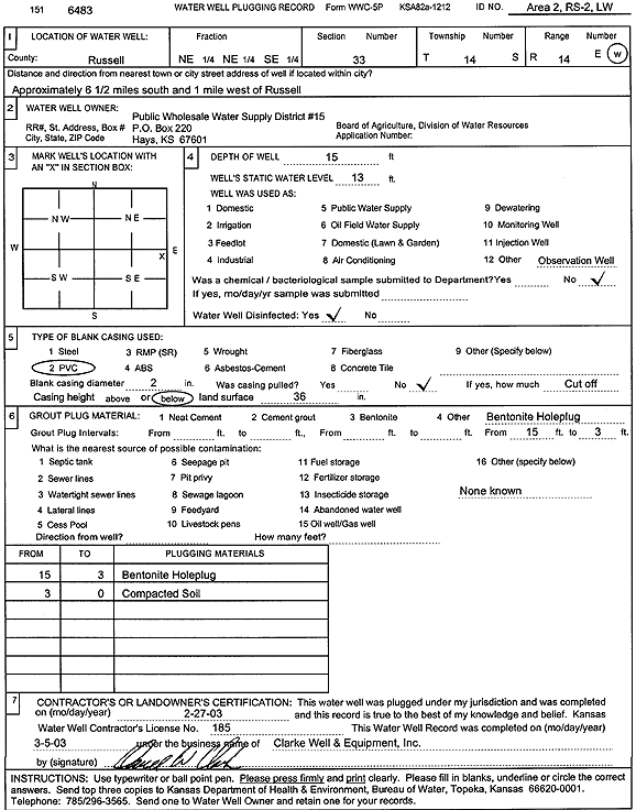
T14S, R14W, Sec. 33 NE NE SE |
Public Wholesale Water Supply District 15 | 15 ft. | 13 ft. | Monitoring well/observation/piezometer | Area 2, RS-2, LW | Plugged | 27-Feb-2003 | Scan | |
|
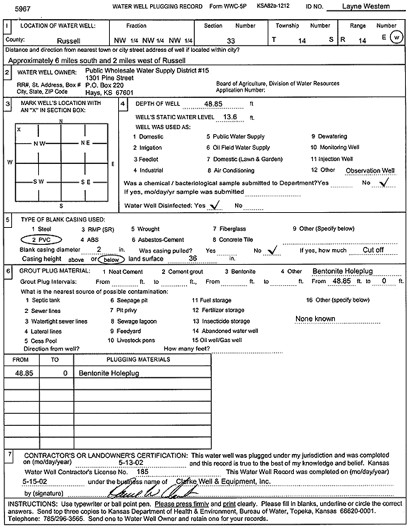
T14S, R14W, Sec. 33 NW NW NW |
Public Wholesale Water Supply District 15 | 48.85 ft. | 13.6 ft. | Monitoring well/observation/piezometer | Layne Western | Plugged | 13-May-2002 | Scan | |
|
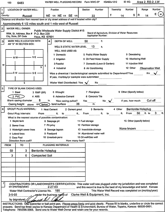
T14S, R14W, Sec. 33 NE NE SE |
Public Wholesale Water Supply District 15 | 50 ft. | 13 ft. | Monitoring well/observation/piezometer | Area 2, RS-2, LW | Plugged | 27-Feb-2003 | Scan | |
|
T14S, R14W, Sec. 33 NE NE NE |
Vonfeldt, Allen | 54 ft. | 30 ft. | Domestic, Lawn and Garden | Plugged | 15-Apr-2006 | |||
|
T14S, R14W, Sec. 33 NE NE NE |
Vonfeldt, Allen | 45 ft. | 30 ft. | 30 gpm. | Domestic | Constructed | 15-Apr-2006 | ||
|
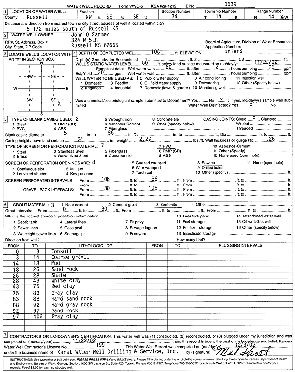
T14S, R14W, Sec. 34 NW SE SE |
Farmer, John O. | 106 ft. | 60 ft. | 20 gpm. | Domestic | Constructed | 22-Nov-2002 | Scan | |
|
T14S, R14W, Sec. 34 NE NE NE SE |
KDHE | 51.54 ft. | 43.48 ft. | Monitoring well/observation/piezometer | MW 03 | Constructed | 15-Jul-1992 | ||
|
T14S, R14W, Sec. 34 NE NE NE SE |
KDHE | 48.53 ft. | 35.41 ft. | Monitoring well/observation/piezometer | MW 01 | Constructed | 15-Jul-1992 | ||
|
T14S, R14W, Sec. 34 NE NE SE |
Russell RWD | 25 ft. | 9 ft. | 200 gpm. | Public Water Supply | Constructed | 19-Nov-1976 | ||
|
T14S, R14W, Sec. 34 NE NE SE |
Russell RWD | 25 ft. | 9 ft. | 200 gpm. | Public Water Supply | Constructed | 19-Nov-1976 | ||
|
T14S, R14W, Sec. 35 W2 NW NW SW |
KDHE | 41.51 ft. | 32.05 ft. | Monitoring well/observation/piezometer | MW 02 | Constructed | 15-Jul-1992 | ||
|
T14S, R14W, Sec. 35 NW SW NW SE |
KDHE | 46.98 ft. | 24.64 ft. | Monitoring well/observation/piezometer | MW 05 | Constructed | 15-Jul-1992 | ||
|
T14S, R14W, Sec. 35 W2 NW NW SW |
KDHE | 41.51 ft. | 32.05 ft. | Monitoring well/observation/piezometer | MW 05 | Constructed | 15-Jul-1992 | ||
|
T14S, R14W, Sec. 35 SW NW SE |
KDHE | 49 ft. | Test hole/well | TH 04 | Plugged | 08-Jul-1992 | |||
|
T14S, R14W, Sec. 35 SW SW SW |
Loring, Chet | 68 ft. | 31 ft. | 40 gpm. | Domestic, Livestock | Constructed | 06-Aug-1976 | ||
|
T14S, R14W, Sec. 35 SW SW SW |
Loring, Chet | 40 ft. | 17 ft. | 40 gpm. | Domestic, Livestock | Constructed | 05-Aug-1976 | ||
|
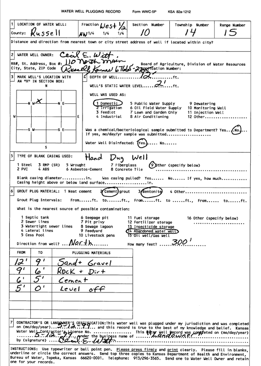
T14S, R15W, Sec. 10 C NW |
Witt, Cecil E. | 18 ft. | 7 ft. | Domestic | Plugged | 12-May-1999 | Scan | ||
|
T14S, R15W, Sec. 10 C NW |
Witt, Cecil E. | 12 ft. | 2 ft. | Domestic | Plugged | 12-May-1999 | Scan | ||
| View page: < Prev || 21 || 22 || 23 || 24 || 25 || 26 || 27 || 28 || 29 || 30 || Next > | |||||||||