Select location of well to view details.
Click on column heading to sort.
|
|
|
County: Scott Select location of well to view details. Click on column heading to sort. |
|
|
|
| View page: < Prev || 21 || 22 || 23 || 24 || 25 || 26 || 27 || 28 || 29 || 30 || Next > | |||||||||
| T-R-S | Owner | Well Depth Ascend. Desc. |
Static Water Level Ascend. Desc. |
Est. Yield Ascend. Desc. |
Well Use | Other ID | Action Taken | Completion Date Ascend. Desc. |
Scan? |
|
T20S, R33W, Sec. 13 NE SE SE |
E-Z Refining Inc | 57 ft. | (unstated)/abandoned | Plugged | 18-May-1988 | ||||
|
T20S, R33W, Sec. 13 SE |
E-Z Serve Inc | 190 ft. | 90 ft. | 425 gpm. | Irrigation | Constructed | 29-Apr-1979 | ||
|
T20S, R33W, Sec. 13 SE SW NW |
H and R Crist Cattle Co | 180 ft. | 113 ft. | 92 gpm. | Domestic, Livestock | Constructed | 15-Jul-1988 | ||
|
T20S, R33W, Sec. 13 NE SE NW |
H and R Crist Cattle Co | 185 ft. | 111 ft. | 50 gpm. | Feedlot | Constructed | 20-Jun-1985 | ||
|
T20S, R33W, Sec. 14 NW NW NW |
Buckner, Van | 137 ft. | Domestic | Plugged | 01-Nov-2010 | ||||
|
T20S, R33W, Sec. 14 NW NW NW NW |
Buckner, Van | 170 ft. | 155 ft. | 12 gpm. | Domestic | Constructed | 24-May-2013 |
KOLAR |
|
|
T20S, R33W, Sec. 14 NE NE NE |
Dague, Albert | 185 ft. | 103 ft. | 300 gpm. | Irrigation | Constructed | 25-Jan-1984 | ||
|
T20S, R33W, Sec. 14 SE SE SE |
Goertzen, Kenneth | 170 ft. | 97 ft. | 10 gpm. | Domestic | Constructed | 23-Aug-1977 | ||
|
T20S, R33W, Sec. 14 SE SE NE |
High Choice Feeders LLC | 88 ft. | Irrigation | Plugged | 26-Nov-2018 | ||||
|
T20S, R33W, Sec. 14 SE SE NE |
High Choice Feeders LLC | 210 ft. | 146 ft. | 200 gpm. | Irrigation | Constructed | 23-Mar-2026 |
KOLAR |
|
|
T20S, R33W, Sec. 14 NE NE NE |
High Choice Feeders No. 1 | 88 ft. | Irrigation | Plugged | 07-Oct-2011 | ||||
|
T20S, R33W, Sec. 14 NE NE SE |
Seed Research Inc | 185 ft. | 107 ft. | Domestic | Constructed | 06-Apr-1982 | |||
|
T20S, R33W, Sec. 15 SE NW SE |
Cheney Farms, Inc. | 191 ft. | 145 ft. | Irrigation | Constructed | 20-Jul-1999 | Scan | ||
|
T20S, R33W, Sec. 15 SW SE NW |
Mohler, George | 150 ft. | 136 ft. | Domestic, Livestock | Constructed | 03-Feb-1987 | |||
|
T20S, R33W, Sec. 15 NW SE SW SW |
Mohler, Rodney and Carolyn | 190 ft. | 150 ft. | 175 gpm. | Irrigation | Constructed | 26-Feb-2021 |
KOLAR |
|
|
T20S, R33W, Sec. 15 NE SW SW |
Mohler, Rodney and Carolyn | 179 ft. | 152 ft. | Irrigation | Plugged | 05-Apr-2023 |
KOLAR |
||
|
T20S, R33W, Sec. 16 SW NW NW |
Lausch Farms | 146 ft. | 130 ft. | Domestic | Constructed | 15-Apr-1986 | |||
|
T20S, R33W, Sec. 16 NW NW SW |
Lausch Farms | 151 ft. | 123 ft. | 200 gpm. | Irrigation | Constructed | 10-Dec-1981 | ||
|
T20S, R33W, Sec. 16 NW SE NW |
Lausch, Fred | 149 ft. | 77 ft. | 600 gpm. | Irrigation | Constructed | 18-Sep-1975 | ||
|
T20S, R33W, Sec. 16 NW SW SE |
Miller, Art | 160 ft. | 101 ft. | 1250 gpm. | Irrigation | Test 1-75 | Constructed | 07-May-1975 | |
|
T20S, R33W, Sec. 16 SE NE SE |
Miller, Arthur/Murfin Drilling | 163 ft. | 132 ft. | Oil Field Water Supply | Constructed | 19-Jun-1986 | |||
|
T20S, R33W, Sec. 17 C SE |
Bradenburg, Roy and Wheeler, Quincey | 161 ft. | 500 gpm. | Irrigation | Constructed | 19-Jan-1976 | |||
|
T20S, R33W, Sec. 17 NW NW SW NW |
Schmitt, Mike | 167 ft. | 119 ft. | 15 gpm. | Domestic | Constructed | 28-Aug-2013 |
KOLAR |
|
|
T20S, R33W, Sec. 18 NW SW |
Harkness, Marie | 97 ft. | 73 ft. | Oil Field Water Supply | Rig 4 | Plugged | 03-Sep-1987 | ||
|
T20S, R33W, Sec. 18 C E2 NW SW |
Harkness, Marie | 97 ft. | 74 ft. | Oil Field Water Supply | Constructed | 18-Aug-1987 | |||
|
T20S, R33W, Sec. 18 NE NE NW |
Keyes, Norman | 140 ft. | 97 ft. | 10 gpm. | Domestic | Constructed | 20-Oct-1975 | ||
|
T20S, R33W, Sec. 19 SE SE SE |
E-Z Serve Inc | 198 ft. | 80 ft. | 1050 gpm. | Industrial | Constructed | 31-May-1977 | ||
|
T20S, R33W, Sec. 20 SE |
Crist, R. L. | 118 ft. | 109 ft. | Irrigation | Plugged | 05-Nov-1992 | |||
|
T20S, R33W, Sec. 21 SE NE NE |
Hutchins, Dan | 165 ft. | 120 ft. | 20 gpm. | Domestic | Constructed | 26-Aug-1977 | ||
|
T20S, R33W, Sec. 21 SE SW NE |
Hutchins, Marion | 135 ft. | 130 ft. | Irrigation | Plugged | 24-Nov-1990 | |||
|
T20S, R33W, Sec. 21 NE NW NE |
Hutchins, Marion | 164 ft. | 132 ft. | 350 gpm. | Irrigation | Constructed | 20-Jul-1990 | ||
|
T20S, R33W, Sec. 21 SE NW NE |
Hutchins, Marion | 150 ft. | 132 ft. | Irrigation | Plugged | 24-Nov-1990 | |||
|
T20S, R33W, Sec. 21 NE NE NE |
Hutchins, Marion | 165 ft. | 120 ft. | 18 gpm. | Domestic | Constructed | 31-Jan-1978 | ||
|
T20S, R33W, Sec. 21 N2 NW |
Savolt, Albert | 155 ft. | 126 ft. | Irrigation | Plugged | 04-Apr-1993 | |||
|
T20S, R33W, Sec. 21 NW NE NW |
Savolt, Albert | 160 ft. | 108 ft. | 600 gpm. | Irrigation | Constructed | 16-Feb-1976 | ||
|
T20S, R33W, Sec. 21 NW NW NW |
Savolt, Albert | 151 ft. | 124 ft. | Irrigation | Plugged | 04-Apr-1993 | |||
|
T20S, R33W, Sec. 22 NW NW SE |
Dague, Etta | 179 ft. | 112 ft. | 175 gpm. | Irrigation | Constructed | 11-Dec-1978 | ||
|
T20S, R33W, Sec. 22 NE NE NE |
Hutchins Bros | 175 ft. | 93 ft. | 1000 gpm. | Irrigation | Constructed | 13-Apr-1976 | ||
|
T20S, R33W, Sec. 22 NW NE NW |
Mohler, George | 182 ft. | 144.5 ft. | 25 gpm. | Domestic | Constructed | 04-Sep-1996 | ||
|
T20S, R33W, Sec. 23 SW NW SW |
Savolt, Albert | 165 ft. | 87 ft. | 2050 gpm. | Irrigation | Test 3-74 | Constructed | 28-Mar-1975 | |
|
T20S, R33W, Sec. 24 SW SW NW |
Cheney, Edwin | 180 ft. | 99 ft. | 10 gpm. | Domestic | Constructed | 25-Oct-1977 | ||
|
T20S, R33W, Sec. 24 NE NE NW |
Cheney, Edwin | 185 ft. | 80 ft. | 1240 gpm. | Irrigation | Constructed | 26-Oct-1976 | ||
|
T20S, R33W, Sec. 24 NE SE NW |
Cheney, Edwin | 194 ft. | 77 ft. | 1430 gpm. | Irrigation | Constructed | 27-Jan-1977 | ||
|
T20S, R33W, Sec. 24 NW NE NW |
Cheney, Howard E | 191 ft. | 124 ft. | 745 gpm. | Irrigation | Constructed | 21-May-1997 | ||
|
T20S, R33W, Sec. 24 SE NW SW SE |
Cornerstone LLC | 224 ft. | 150 ft. | 398 gpm. | Irrigation | Constructed | 06-Oct-2015 |
KOLAR |
|
|
T20S, R33W, Sec. 24 NE NE SE |
Dague, Roy | 178 ft. | 128 ft. | 32 gpm. | Domestic | Constructed | 30-Jul-2004 | ||
|
T20S, R33W, Sec. 24 NE NE NE |
Stiles Family Trust | 189 ft. | 124 ft. | Irrigation | Constructed | 18-Sep-2002 | Scan | ||
|
T20S, R33W, Sec. 24 SE SE NE |
Stiles, Vern | 16 ft. | Domestic, Livestock | Plugged | 18-Oct-2004 | ||||
|
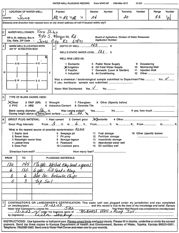
T20S, R33W, Sec. 24 NE NE NE |
Stiles, Vern | 145 ft. | 121 ft. | Irrigation | Plugged | 22-Oct-2002 | Scan | ||
|
T20S, R33W, Sec. 24 NE NE SE |
Thomas, Tony | 178 ft. | 133 ft. | Domestic | Plugged | 25-Jan-2016 | |||
| View page: < Prev || 21 || 22 || 23 || 24 || 25 || 26 || 27 || 28 || 29 || 30 || Next > | |||||||||