Select location of well to view details.
Click on column heading to sort.
|
|
|
County: Seward Select location of well to view details. Click on column heading to sort. |
|
|
|
| View page: < Prev || 11 || 12 || 13 || 14 || 15 || 16 || 17 || 18 || 19 || 20 || Next > | |||||||||
| T-R-S | Owner | Well Depth Ascend. Desc. |
Static Water Level Ascend. Desc. |
Est. Yield Ascend. Desc. |
Well Use | Other ID | Action Taken | Completion Date Ascend. Desc. |
Scan? |
|
T33S, R31W, Sec. 19 SW SW SE NE |
Davies, Bob | 260 ft. | 217 ft. | 30 gpm. | Domestic, Livestock | Constructed | 30-Apr-2013 |
KOLAR |
|
|
T33S, R31W, Sec. 19 SW SE NE |
Davies, Bob | 243 ft. | 217 ft. | Domestic | Plugged | 30-May-2013 | |||
|
T33S, R31W, Sec. 20 NE SW NE |
Handy, J.L. | 418 ft. | 190 ft. | 2200 gpm. | Irrigation | Constructed | 08-May-1976 | ||
|
T33S, R31W, Sec. 20 SW NW |
Handy, John | 567 ft. | 169 ft. | 1600 gpm. | Irrigation | Constructed | 09-Apr-2015 | ||
|
T33S, R31W, Sec. 20 SE SE SE |
Handy, John | 500 ft. | 251 ft. | Domestic, Livestock | Constructed | 05-Sep-2024 |
KOLAR |
||
|
T33S, R31W, Sec. 20 SE NW SW |
Handy, Jon | 175 ft. | 0 ft. | Domestic, Livestock | Plugged | 24-May-2023 |
KOLAR |
||
|
T33S, R31W, Sec. 20 NW NE NE |
Handy, Jon | 189 ft. | 127 ft. | Domestic | Plugged | 26-Mar-2025 |
KOLAR |
||
|
T33S, R31W, Sec. 21 NW SE NW |
Dekalb Feed Yard | 360 ft. | 200 ft. | 50 gpm. | Industrial | Feedlot Well 4 | Constructed | 04-Oct-1975 | |
|
T33S, R31W, Sec. 21 NW SE SE |
Dekalb Feed Yard | 360 ft. | 197 ft. | 160 gpm. | Industrial | Feedlot Well 3 | Constructed | 17-Apr-1975 | |
|
T33S, R31W, Sec. 21 NE NE NW |
Dekalb Swine Breeders, Inc. | 410 ft. | 187 ft. | 2131 gpm. | Irrigation | Constructed | 23-Mar-1978 | ||
|
T33S, R31W, Sec. 21 C SE |
Hedrick, Dean | 452 ft. | 205 ft. | Irrigation | Constructed | 16-Feb-1976 | |||
|
T33S, R31W, Sec. 21 NE SW SE NE |
KSF/Farm 3-15, Kansas-Smith Farms LLC | 480 ft. | 250 ft. | 130 gpm. | Industrial | Constructed | 04-Sep-2017 |
KOLAR |
|
|
T33S, R31W, Sec. 22 SE NE NE |
Rinehart, Vee | 561 ft. | 212 ft. | 1410 gpm. | Irrigation | Constructed | 25-Mar-1998 | ||
|
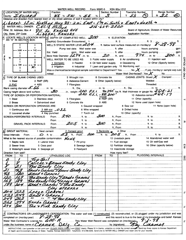
T33S, R31W, Sec. 23 NW NW NE |
Cox, Darin and Maria | 390 ft. | 257 ft. | Domestic | Constructed | 17-Jun-2024 |
KOLAR |
||
|
T33S, R31W, Sec. 23 S2 S2 SE |
Neumann-Wheatly Farms Inc. | 503 ft. | 215 ft. | 1615 gpm. | Irrigation | Constructed | 05-Dec-1997 | ||
|
T33S, R31W, Sec. 23 NE NE |
Ryan, David | 360 ft. | 185 ft. | Domestic | Constructed | 11-May-2000 | Scan | ||
|
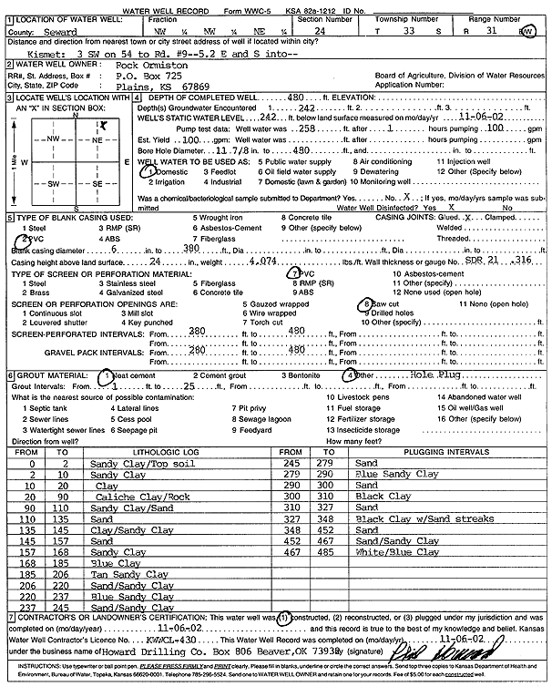
T33S, R31W, Sec. 24 NW NW NE |
Ormiston, Rock | 480 ft. | 242 ft. | 100 gpm. | Domestic | Constructed | 06-Nov-2002 | Scan | |
|
T33S, R31W, Sec. 24 C NW |
Parity Grain | 428 ft. | 198 ft. | 1204 gpm. | Irrigation | Constructed | 05-Jun-1997 | ||
|
T33S, R31W, Sec. 24 SE SW NE |
Parity Grain | 564 ft. | 228 ft. | Irrigation | Constructed | 26-Apr-2002 | Scan | ||
|
T33S, R31W, Sec. 25 W2 NW SE |
Diamond Shamrock | 320 ft. | 193 ft. | 60 gpm. | Oil Field Water Supply | Sleeper A 1 | Constructed | 19-Oct-1981 | |
|
T33S, R31W, Sec. 25 C SE |
Fox, Warren and Susan | 435 ft. | 198 ft. | Irrigation | Constructed | 12-Jun-1997 | |||
|
T33S, R31W, Sec. 25 SW NW NW |
Oil Producers Inc. of Kansas | 360 ft. | 100 ft. | 100 gpm. | Oil Field Water Supply | Hughbanks 1-25 | Constructed | 21-Jul-2009 | |
|
T33S, R31W, Sec. 25 SW SW SW |
Parity Grain | 516 ft. | 218 ft. | Irrigation | Constructed | 07-Mar-2001 | Scan | ||
|
T33S, R31W, Sec. 25 SE SE |
Sage Drilling Company | 260 ft. | 180 ft. | 40 gpm. | Oil Field Water Supply | Constructed | 08-Aug-1977 | ||
|
T33S, R31W, Sec. 26 NE NE SW |
Brown, L.H. | 503 ft. | 208 ft. | 1320 gpm. | Irrigation | Constructed | 19-Mar-1996 | ||
|
T33S, R31W, Sec. 26 NE NE SE |
Guldner, Josephine/Abercrombie RTD | 370 ft. | 205 ft. | Oil Field Water Supply | Constructed | 04-Feb-1997 | |||
|
T33S, R31W, Sec. 27 SE SE NE |
Southwest Agri-Center | 557 ft. | 219 ft. | 1600 gpm. | Irrigation | Constructed | 04-Apr-1998 | ||
|
T33S, R31W, Sec. 28 NW NW NE |
Handy, A.J. | 400 ft. | 215 ft. | Domestic | Constructed | 19-Aug-1998 | |||
|
T33S, R31W, Sec. 28 NW SE SE |
Handy, A.J. | 410 ft. | 180 ft. | 2000 gpm. | Irrigation | Constructed | 27-Aug-1976 | ||
|
T33S, R31W, Sec. 28 SW NW NW |
Handy, John | 540 ft. | 210 ft. | 2000 gpm. | Irrigation | Constructed | 10-Sep-2000 | ||
|
T33S, R31W, Sec. 28 NE NE |
Zenith Drilling Co. | 300 ft. | 189 ft. | 50 gpm. | Industrial | Handy 1 | Constructed | 13-May-1975 | |
|
T33S, R31W, Sec. 29 SW SW NE |
Handy, Jon | 170 ft. | 0 ft. | Domestic, Livestock | Plugged | 24-May-2023 |
KOLAR |
||
|
T33S, R31W, Sec. 31 NE NW NW |
Davies, Rice E. | 78 ft. | 15 ft. | 50 gpm. | Domestic | Constructed | 05-Apr-1983 | ||
|
T33S, R31W, Sec. 33 SE NE NE |
Handy, A.J. | 340 ft. | 193 ft. | 100 gpm. | Oil Field Water Supply | Handy 1 | Constructed | 17-Oct-1987 | |
|
T33S, R31W, Sec. 34 NW NE NW NW |
Kansas-Smith Farms, LLC | 325 ft. | 235 ft. | 90 gpm. | Domestic, Livestock | Constructed | 08-Oct-2015 |
KOLAR |
|
|
T33S, R31W, Sec. 34 NE NE NW |
Parity Grain | 557 ft. | 218 ft. | 1482 gpm. | Irrigation | Constructed | 15-Oct-1998 | Scan | |
|
T33S, R31W, Sec. 34 NW NW NW |
Winn Enterprises | 320 ft. | 200 ft. | 100 gpm. | Domestic, Livestock | Constructed | 07-Sep-1995 | ||
|
T33S, R31W, Sec. 35 NE NE NW |
Parity Grain | 498 ft. | 218 ft. | Irrigation | Constructed | 11-Apr-2000 | Scan | ||
|
T33S, R31W, Sec. 35 NE NE SW SW |
Parity Investments Inc. | 562 ft. | 250 ft. | 1631 gpm. | Irrigation | Constructed | 19-Nov-2013 |
KOLAR |
|
|
T33S, R31W, Sec. 36 SW NE SW NE |
Parity Investments Inc. | 509 ft. | 245 ft. | 1043 gpm. | Irrigation | Constructed | 21-Nov-2013 |
KOLAR |
|
|
T33S, R32W, Sec. 2 SW NE NE |
Wettstein, C.J. | 374 ft. | 195 ft. | 2000 gpm. | Irrigation | Constructed | 31-May-1977 | ||
|
T33S, R32W, Sec. 4 C NE NE |
Anadarko Petroleum Corp. | 400 ft. | 215 ft. | 85 gpm. | Oil Field Water Supply | Milhon B 1 | Constructed | 11-Nov-1997 | |
|
T33S, R32W, Sec. 4 C NW SE |
Milhon, Cecil | 220 ft. | 195 ft. | 15 gpm. | Domestic | Constructed | 02-May-1985 | ||
|
T33S, R32W, Sec. 4 NE NE SW |
Milhon, Cecil | 370 ft. | 180 ft. | Domestic | Constructed | 12-Aug-2008 | |||
|
T33S, R32W, Sec. 5 NE SW SE |
Milhon, Cecil | 300 ft. | 204 ft. | Domestic | Constructed | 28-Aug-1998 | Scan | ||
|
T33S, R32W, Sec. 5 NE NE SW |
Watson, John | 300 ft. | 151 ft. | Domestic | Constructed | 16-Jul-1980 | |||
|
T33S, R32W, Sec. 5 NE NE NE |
Wright, Lindsay | 385 ft. | 234 ft. | Domestic, Livestock | Constructed | 02-Mar-2022 |
KOLAR |
||
|
T33S, R32W, Sec. 6 NE NW NW |
Lambert, Joe | 260 ft. | 45 ft. | 2000 gpm. | Irrigation | Constructed | 07-Aug-1998 | ||
|
T33S, R32W, Sec. 7 C NW |
Pittman, Kenneth | 152 ft. | 4 ft. | 1500 gpm. | Irrigation | Constructed | 21-Apr-1976 | ||
|
T33S, R32W, Sec. 8 SW NW NE |
Milhon, Cecil | 258 ft. | 104 ft. | 2500 gpm. | Irrigation | Constructed | 28-Jun-1976 | ||
| View page: < Prev || 11 || 12 || 13 || 14 || 15 || 16 || 17 || 18 || 19 || 20 || Next > | |||||||||