Select location of well to view details.
Click on column heading to sort.
|
|
|
County: Seward Select location of well to view details. Click on column heading to sort. |
|
|
|
| View page: < Prev || 21 || 22 || 23 || 24 || 25 || 26 || 27 || 28 || 29 || 30 || Next > | |||||||||
| T-R-S | Owner | Well Depth Ascend. Desc. |
Static Water Level Ascend. Desc. |
Est. Yield Ascend. Desc. |
Well Use | Other ID | Action Taken | Completion Date Ascend. Desc. |
Scan? |
|
T33S, R34W, Sec. 32 SE SE SW |
Reever, Daniel | 103 ft. | Domestic | Plugged | 19-Aug-2004 | ||||
|
T33S, R34W, Sec. 32 SW SW SE |
Reever, Lavene | 560 ft. | 272 ft. | 50 gpm. | Domestic | Constructed | 03-Aug-2012 | ||
|
T33S, R34W, Sec. 32 SW SW SE |
Reever, Lorene | 300 ft. | 197 ft. | 20 gpm. | Domestic | Constructed | 14-Apr-2006 | ||
|
T33S, R34W, Sec. 33 NE NE SW |
Nix, Steve | 610 ft. | 210 ft. | Irrigation | Constructed | 28-Dec-2004 | |||
|
T33S, R34W, Sec. 34 C E2 SW |
Anadarko Production Co. | 280 ft. | 113 ft. | 60 gpm. | Oil Field Water Supply | Crow A 2 | Constructed | 15-Oct-1980 | |
|
T33S, R34W, Sec. 34 C NE NE |
Anadarko Production Co. | 280 ft. | Oil Field Water Supply | Malin A 1 | Plugged | 31-Dec-1981 | |||
|
T33S, R34W, Sec. 34 C NE NE |
Anadarko Production Co. | 280 ft. | 135 ft. | 60 gpm. | Oil Field Water Supply | Malin A 1 | Constructed | 06-Aug-1981 | |
|
T33S, R34W, Sec. 34 SW SW SW |
Fry, Fred | 175 ft. | Monitoring well/observation/piezometer | MW 6 R | Constructed | 11-Dec-2006 | |||
|
T33S, R34W, Sec. 34 SE SE SW |
Nix, Loren | 637 ft. | 161 ft. | Irrigation | Constructed | 06-May-1994 | |||
|
T33S, R34W, Sec. 35 NE SE SE |
Fitzgerald, Mike | 300 ft. | 200 ft. | Oil Field Water Supply | Cook 4-35 | Constructed | 19-Apr-1996 | ||
|
T33S, R34W, Sec. 35 C SW |
Malin, Randy/Cabot Corp. | 280 ft. | 128 ft. | 60 gpm. | Oil Field Water Supply | Cook 2 | Constructed | 16-Jul-1983 | |
|
T33S, R34W, Sec. 36 NE NE NW |
Mendoza-Nieblas, Diana | 340 ft. | 205 ft. | 45 gpm. | Domestic | Constructed | 10-Jun-2023 |
KOLAR |
|
|
T34S, R31W, Sec. 1 C NE SW |
Black, Gene | 340 ft. | 185 ft. | 60 gpm. | Oil Field Water Supply | Constructed | 10-Dec-1981 | ||
|
T34S, R31W, Sec. 1 SE |
Hutchinson National Bank | 445 ft. | 213 ft. | 1775 gpm. | Irrigation | Constructed | 02-Jan-1981 | ||
|
T34S, R31W, Sec. 1 SW SW NW NE |
Thorp, Don | 488 ft. | 248 ft. | 50 gpm. | Domestic, Livestock | Constructed | 06-Apr-2021 |
KOLAR |
|
|
T34S, R31W, Sec. 2 SE SW NW |
Black, Gene | 360 ft. | 198 ft. | 100 gpm. | Oil Field Water Supply | Gene Black A 1 | Constructed | 21-Jan-1987 | |
|
T34S, R31W, Sec. 2 SW NW SW |
Gene Black Trust | 235 ft. | 222 ft. | Domestic | Plugged | 08-May-2012 | |||
|
T34S, R31W, Sec. 2 SW NW SW |
Gene Black Trust | 343 ft. | 220 ft. | 50 gpm. | Domestic | Constructed | 01-Aug-2012 | ||
|
T34S, R31W, Sec. 3 SW SW NE |
Gene Black Trust | 367 ft. | 226 ft. | 50 gpm. | Domestic, Livestock | Constructed | 23-Apr-2015 | ||
|
T34S, R31W, Sec. 3 C SW NW |
Oil Producers Inc. of KS | 240 ft. | 168 ft. | 100 gpm. | Oil Field Water Supply | Black 1 3 | Constructed | 30-Jul-2008 | |
|
T34S, R31W, Sec. 3 NE SW |
Sage Drilling Co. | 240 ft. | 167 ft. | 60 gpm. | Oil Field Water Supply | Tlatt 1-3 | Constructed | 09-Aug-1979 | |
|
T34S, R31W, Sec. 4 SW SW SW |
Davies, Bob Jr. | 100 ft. | 37 ft. | 70 gpm. | Oil Field Water Supply | Constructed | 18-Mar-1997 | ||
|
T34S, R31W, Sec. 5 C NE NE |
Anadarko Petroleum Corp. | 200 ft. | 65 ft. | 110 gpm. | Oil Field Water Supply | McClure H 1 | Constructed | 25-Mar-1997 | |
|
T34S, R31W, Sec. 5 NE NE SE NE |
Davies, Bob | 180 ft. | 84 ft. | 50 gpm. | Domestic, Livestock | Constructed | 22-Dec-2016 |
KOLAR |
|
|
T34S, R31W, Sec. 6 NE NE NE |
Anadarko Petroleum | 280 ft. | 15 ft. | 100 gpm. | Oil Field Water Supply | Davies G 2 | Constructed | 11-Jun-1998 | |
|
T34S, R31W, Sec. 7 NE SE NE |
Davies, Bob | 140 ft. | 27 ft. | 50 gpm. | Domestic | Constructed | 04-Jun-2007 | ||
|
T34S, R31W, Sec. 7 NW NE SE |
Mahan, Mr. Jodie | 150 ft. | 42 ft. | 50 gpm. | Domestic | Reconstructed | 25-Jul-1984 | ||
|
T34S, R31W, Sec. 8 NW NE NE |
Anadarko Petroleum Corp. | 140 ft. | 15 ft. | Oil Field Water Supply | Davis F 1 | Plugged | 01-Aug-1998 | ||
|
T34S, R31W, Sec. 8 W2 NE NE |
Anadarko Petroleum Corp. | 140 ft. | 15 ft. | 100 gpm. | Oil Field Water Supply | Davies F 1 | Constructed | 07-Aug-1996 | |
|
T34S, R31W, Sec. 8 NE SW SW |
Brungardt, Jim | 150 ft. | 62 ft. | 20 gpm. | Domestic | Constructed | 06-Jul-1988 | ||
|
T34S, R31W, Sec. 9 C SW SE |
Davies, Rice | 120 ft. | 8 ft. | 60 gpm. | Oil Field Water Supply | Davies 1 | Constructed | 04-Dec-1981 | |
|
T34S, R31W, Sec. 10 SW SW NE |
Davies, Bob | 240 ft. | 143 ft. | 30 gpm. | Domestic | Constructed | 29-Nov-1983 | ||
|
T34S, R31W, Sec. 11 SE NW SW |
Gabbert and Jones | 300 ft. | 185 ft. | 50 gpm. | Oil Field Water Supply | Constructed | 18-May-1983 | ||
|
T34S, R31W, Sec. 12 NE NE SW |
Davies, Bob Jr. | 280 ft. | 215 ft. | 15 gpm. | Domestic | Constructed | 12-Aug-1985 | ||
|
T34S, R31W, Sec. 12 NW NW NW |
Gabbert and Jones | 300 ft. | 230 ft. | Oil Field Water Supply | Young Nall | Plugged | 04-Sep-1984 | ||
|
T34S, R31W, Sec. 12 NW NW NW |
Gabbert and Jones | 300 ft. | 230 ft. | 65 gpm. | Oil Field Water Supply | Young Nall | Constructed | 17-Aug-1984 | |
|
T34S, R31W, Sec. 12 NE NE NE |
Ivan Gruber Estate | 400 ft. | 220 ft. | 50 gpm. | Domestic | Constructed | 06-Sep-1996 | ||
|
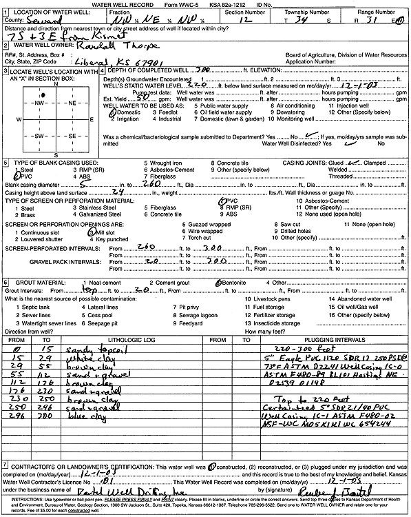
T34S, R31W, Sec. 12 NW NE NW |
Thorpe, Randall | 300 ft. | 220 ft. | 50 gpm. | Domestic | Constructed | 01-Dec-2003 | Scan | |
|
T34S, R31W, Sec. 13 SW NW |
Keating Estate | 280 ft. | 155 ft. | 60 gpm. | Oil Field Water Supply | Nilie Keating 1 | Constructed | 24-Dec-1981 | |
|
T34S, R31W, Sec. 13 NE SE NW NE |
Mid America Cattle Co. | 500 ft. | 248 ft. | 50 gpm. | Domestic, Livestock | Constructed | 26-Aug-2021 |
KOLAR |
|
|
T34S, R31W, Sec. 13 NW SE SW NW |
Mid America Cattle Co. | 460 ft. | 181 ft. | 50 gpm. | Domestic, Livestock | Constructed | 24-Aug-2021 |
KOLAR |
|
|
T34S, R31W, Sec. 14 SW NE SW SW |
Mid America Cattle Co | 300 ft. | 31 ft. | 50 gpm. | Domestic, Livestock | Constructed | 10-Apr-2018 | ||
|
T34S, R31W, Sec. 14 NW NW |
Unit Drilling Company Rig 1 | 200 ft. | 98 ft. | 60 gpm. | Industrial | Keating 1 | Constructed | 03-Jun-1975 | |
|
T34S, R31W, Sec. 15 SE NE SW |
Adams, Kell | 200 ft. | 35 ft. | 80 gpm. | Domestic | Constructed | 01-Aug-2008 | ||
|
T34S, R31W, Sec. 15 NE SW SE |
Noble Energy | 65 ft. | 7 ft. | 90 gpm. | Oil Field Water Supply | Constructed | 14-Apr-2010 | ||
|
T34S, R31W, Sec. 16 SE SE NE |
Pittman, Ed | 31 ft. | 18 ft. | Domestic | Plugged | 04-Aug-2017 | |||
|
T34S, R31W, Sec. 16 SE SE NE |
Pittman, Ed | 24 ft. | Domestic | Plugged | 04-Aug-2017 | ||||
|
T34S, R31W, Sec. 16 NW NW |
Unit Drilling Company Rig 1 | 100 ft. | 20 ft. | 50 gpm. | Industrial | Good 1 | Constructed | 01-Oct-1975 | |
|
T34S, R31W, Sec. 17 NE NE NE |
Pittman, Ed | 16 ft. | Domestic | Plugged | 04-Aug-2017 | ||||
|
T34S, R31W, Sec. 18 C SW NE |
Gabbert and Jones, Inc. | 380 ft. | 155 ft. | 70 gpm. | Oil Field Water Supply | Constructed | 19-Jan-1976 | ||
| View page: < Prev || 21 || 22 || 23 || 24 || 25 || 26 || 27 || 28 || 29 || 30 || Next > | |||||||||