Select location of well to view details.
Click on column heading to sort.
|
|
|
County: Seward Select location of well to view details. Click on column heading to sort. |
|
|
|
| View page: < Prev || 51 || 52 || 53 || 54 || 55 || 56 || 57 || 58 || 59 || 60 | |||||||||
| T-R-S | Owner | Well Depth Ascend. Desc. |
Static Water Level Ascend. Desc. |
Est. Yield Ascend. Desc. |
Well Use | Other ID | Action Taken | Completion Date Ascend. Desc. |
Scan? |
|
T35S, R33W, Sec. 5 SE NE NE |
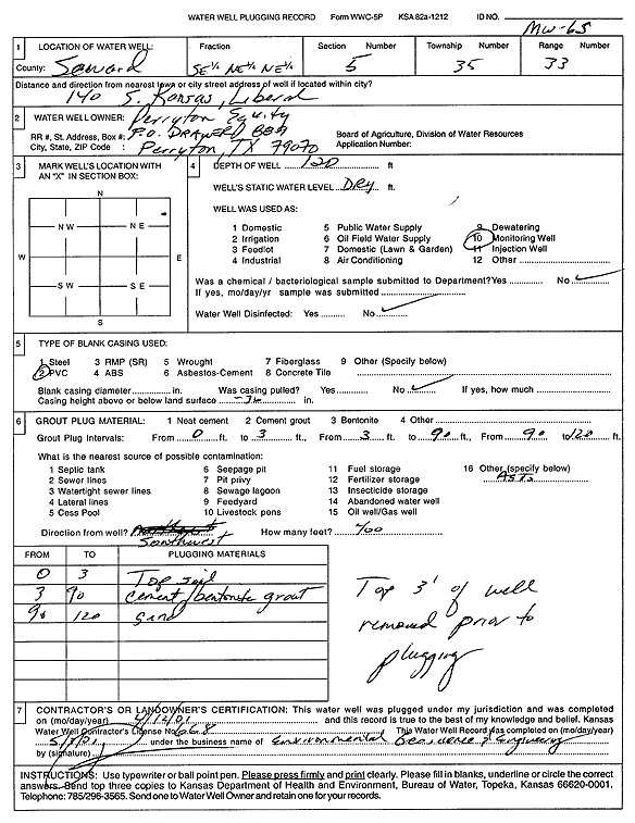
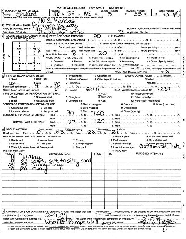
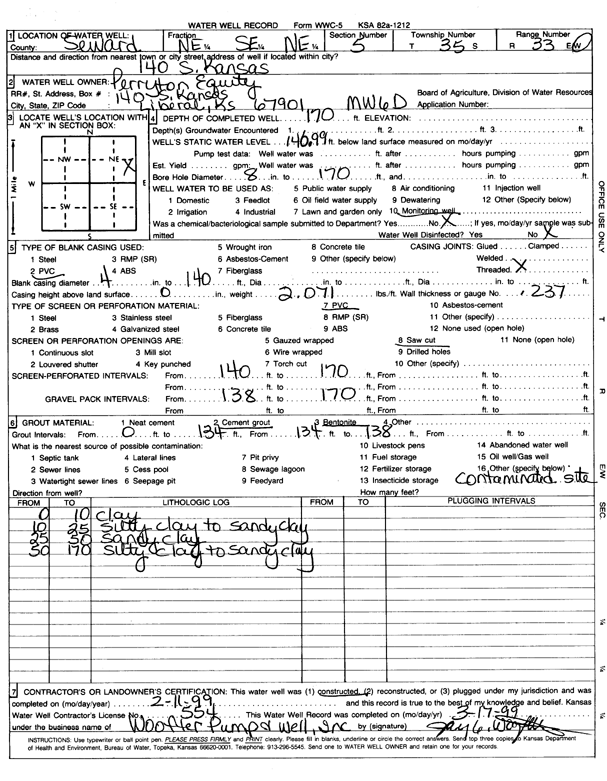
Perryton Equity | 120 ft. | Monitoring well/observation/piezometer | MW 6 S | Plugged | 12-Apr-2001 | Scan | ||
|
T35S, R33W, Sec. 5 NE SE NE |
Perryton Equity | 120 ft. | 119 ft. | Monitoring well/observation/piezometer | LMW 1 S | Plugged | 12-Jun-2007 | ||
|
T35S, R33W, Sec. 5 SE NE NE |
Perryton Equity | 200 ft. | Monitoring well/observation/piezometer | LMW 10 D | Constructed | 08-Jun-2007 | |||
|
T35S, R33W, Sec. 5 NE SE NE |
Perryton Equity | 120 ft. | 116 ft. | Monitoring well/observation/piezometer | LMW 4 S | Plugged | 12-Jun-2007 | ||
|
T35S, R33W, Sec. 5 NE SE NE |
Perryton Equity | 200 ft. | Monitoring well/observation/piezometer | LMW 9 D | Constructed | 07-Jun-2007 | |||
|
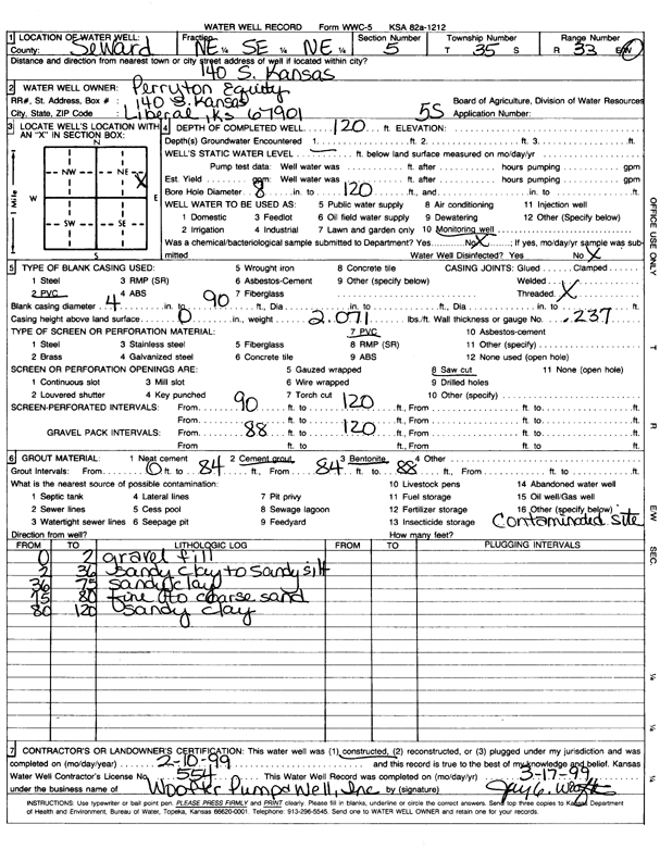
T35S, R33W, Sec. 5 NE SE NE |
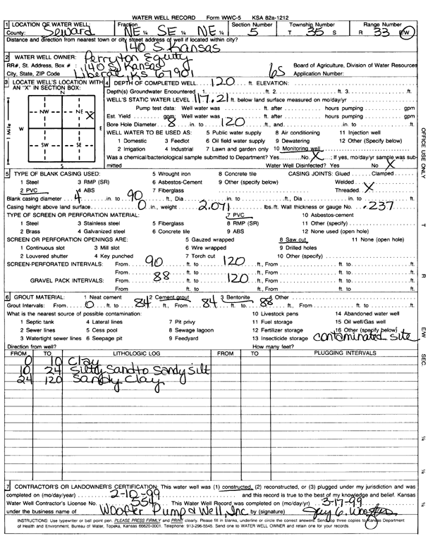
Perryton Equity | 120 ft. | Monitoring well/observation/piezometer | 5 S | Constructed | 10-Feb-1999 | Scan | ||
|
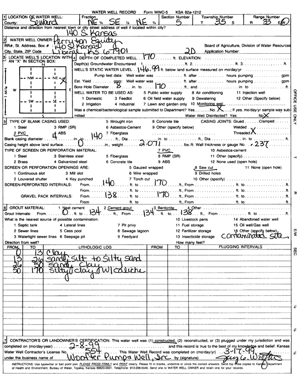
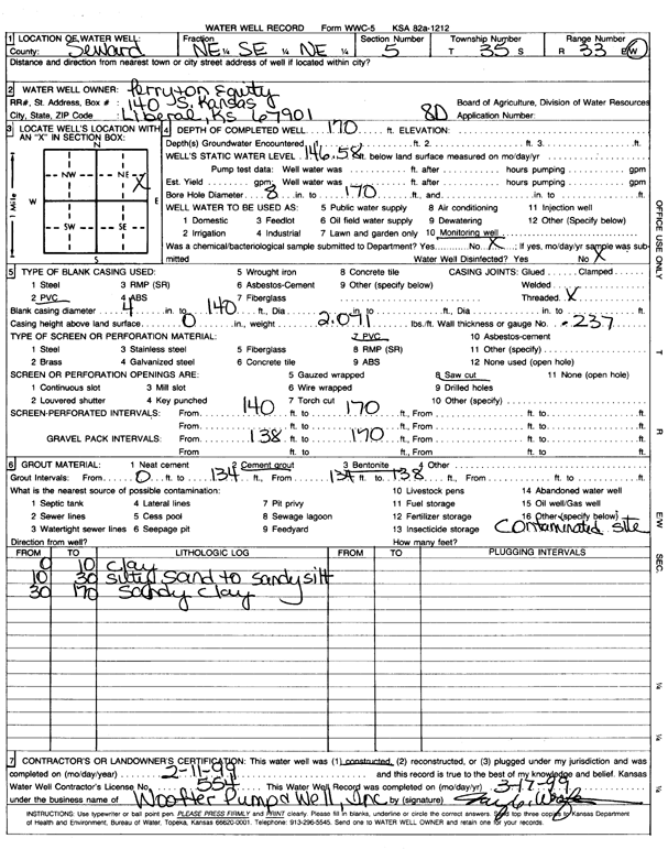
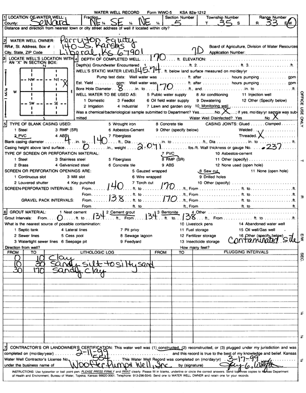
T35S, R33W, Sec. 5 NE SE NE |
Perryton Equity | 170 ft. | 146.9 ft. | Monitoring well/observation/piezometer | 2 D | Constructed | 08-Feb-1999 | Scan | |
|
T35S, R33W, Sec. 5 NE NE SE NE |
Perryton Equity | 165.4 ft. | 0 ft. | Monitoring well/observation/piezometer | LMW-7D | Plugged | 15-Oct-2015 |
KOLAR |
|
|
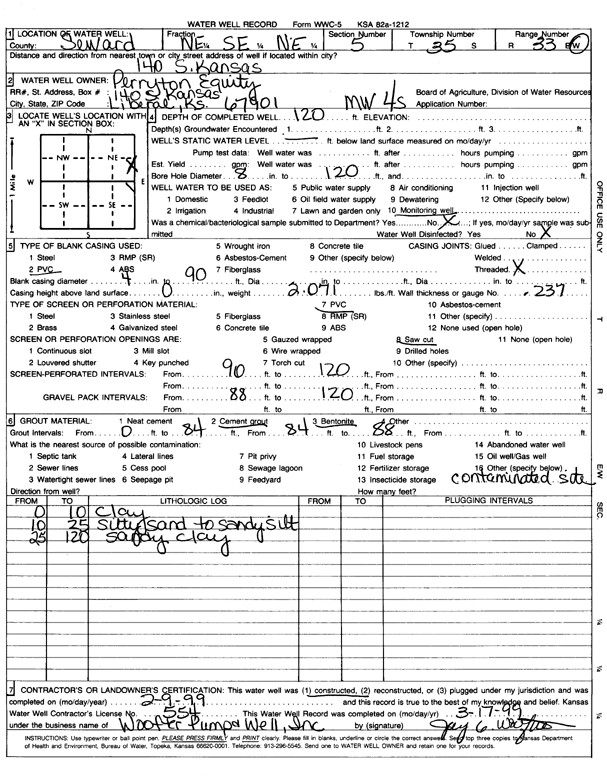
T35S, R33W, Sec. 5 NE SE NE |
Perryton Equity | 120 ft. | Monitoring well/observation/piezometer | MW 4 S | Constructed | 09-Feb-1999 | Scan | ||
|
T35S, R33W, Sec. 5 NE SE NE |
Perryton Equity | 210 ft. | 184.58 ft. | 5 gpm. | Monitoring well/observation/piezometer | LMW 11D | Constructed | 27-Apr-2022 |
KOLAR |
|
T35S, R33W, Sec. 5 NE NE SE NE |
Perryton Equity | 163.6 ft. | 0 ft. | Monitoring well/observation/piezometer | LMW-2D | Plugged | 15-Oct-2015 |
KOLAR |
|
|
T35S, R33W, Sec. 5 NE SE NE |
Perryton Equity | 170 ft. | 146.5 ft. | Monitoring well/observation/piezometer | 8 D | Constructed | 11-Feb-1999 | Scan | |
|
T35S, R33W, Sec. 5 NE SE NE |
Perryton Equity | 120 ft. | Monitoring well/observation/piezometer | 3 S | Constructed | 09-Feb-1999 | Scan | ||
|
T35S, R33W, Sec. 5 NE NE SE NE |
Perryton Equity | 165.9 ft. | 2 ft. | Monitoring well/observation/piezometer | LMW-8D | Plugged | 15-Oct-2015 |
KOLAR |
|
|
T35S, R33W, Sec. 5 NE SE NE |
Perryton Equity | 170 ft. | 145.7 ft. | Monitoring well/observation/piezometer | 7 D | Constructed | 11-Feb-1999 | Scan | |
|
T35S, R33W, Sec. 5 NE SE NE |
Perryton Equity | 170 ft. | 146.9 ft. | Monitoring well/observation/piezometer | MW 6 D | Constructed | 11-Feb-1999 | Scan | |
|
T35S, R33W, Sec. 5 NE SE NE |
Perryton Equity | 120 ft. | 117.2 ft. | Monitoring well/observation/piezometer | 6 S | Constructed | 10-Feb-1999 | Scan | |
|
T35S, R33W, Sec. 5 NW SW SW |
Redman, Rodger | 169.4 ft. | 152.46 ft. | Monitoring well/observation/piezometer | MW 2 | Plugged | 18-Oct-2004 | ||
|
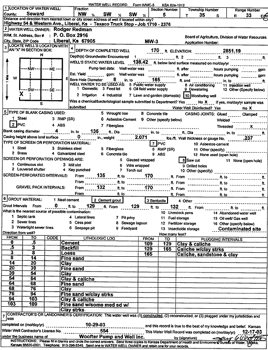
T35S, R33W, Sec. 5 NW SW SW |
Redman, Rodger | 170 ft. | 138.42 ft. | Monitoring well/observation/piezometer | MW 3 | Constructed | 29-Oct-2003 | Scan | |
|
T35S, R33W, Sec. 5 NW SW SW |
Redman, Rodger | 174.2 ft. | 151.2 ft. | Monitoring well/observation/piezometer | MW 1 | Plugged | 18-Oct-2004 | ||
|
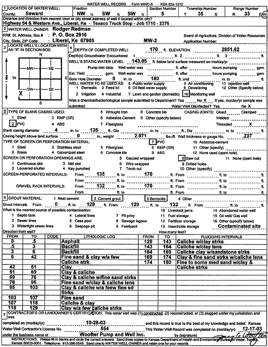
T35S, R33W, Sec. 5 NW SW SW |
Redman, Rodger | 170 ft. | 143.05 ft. | Monitoring well/observation/piezometer | MW 2 | Constructed | 28-Oct-2003 | Scan | |
|
T35S, R33W, Sec. 5 NW SW SW |
Redman, Rodger | 167.91 ft. | 151.33 ft. | Monitoring well/observation/piezometer | MW 3 | Plugged | 18-Oct-2004 | ||
|
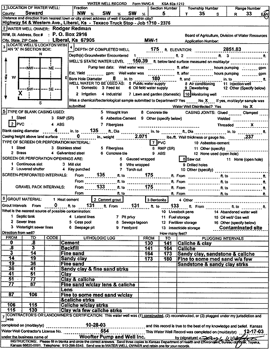
T35S, R33W, Sec. 5 NW SW SW |
Redman, Rodger | 175 ft. | 150.39 ft. | Monitoring well/observation/piezometer | MW 1 | Constructed | 28-Oct-2003 | Scan | |
|
T35S, R33W, Sec. 5 C SW SW |
Tradewinds Industries Inc | 280 ft. | 140 ft. | 60 gpm. | Industrial | Constructed | 25-Apr-1984 | ||
|
T35S, R33W, Sec. 5 NW NW NW |
Warren, Ron | 170 ft. | 144.4 ft. | Monitoring well/observation/piezometer | MW 6 R | Constructed | 01-May-2006 | ||
|
T35S, R33W, Sec. 5 NW NW NW |
Warren, Ron | 180 ft. | Monitoring well/observation/piezometer | MW 7 R | Constructed | 14-Aug-2012 | |||
|
T35S, R33W, Sec. 5 NW NW NW |
Wes-Kan Oil Co., Inc. | 165 ft. | Monitoring well/observation/piezometer | MW 11 | Constructed | 09-Nov-2004 | |||
|
T35S, R33W, Sec. 5 NE NE SE |
Wes-Kan Oil Co., Inc. | 170 ft. | 162.5 ft. | Monitoring well/observation/piezometer | MW 2 | Plugged | 21-Mar-2013 | ||
|
T35S, R33W, Sec. 5 NE NE SE |
Wes-Kan Oil Co., Inc. | 200 ft. | Monitoring well/observation/piezometer | MW 2 R | Constructed | 18-Mar-2013 | |||
|
T35S, R33W, Sec. 5 NE NE SE |
Wes-Kan Oil Co., Inc. | 164.9 ft. | Monitoring well/observation/piezometer | MW 3 | Plugged | 21-Mar-2013 | |||
|
T35S, R33W, Sec. 5 NE NE SE |
Wes-Kan Oil Co., Inc. | 200 ft. | Monitoring well/observation/piezometer | MW 3 R | Constructed | 20-Mar-2013 | |||
|
T35S, R33W, Sec. 5 NE NE SE |
Wes-Kan Oil Co., Inc. | 163.8 ft. | Monitoring well/observation/piezometer | MW 1 | Plugged | 21-Mar-2013 | |||
|
T35S, R33W, Sec. 5 NE NE SE |
Wes-Kan Oil Co., Inc. | 200 ft. | Monitoring well/observation/piezometer | MW 7 | Constructed | 21-Mar-2013 | |||
|
T35S, R33W, Sec. 5 NE NE SE |
Wes-Kan Oil Co., Inc. | 200 ft. | Monitoring well/observation/piezometer | MW 6 | Constructed | 15-Mar-2013 | |||
|
T35S, R33W, Sec. 5 NE NE SE |
Wes-Kan Oil Co., Inc. | 164 ft. | Monitoring well/observation/piezometer | MW 4 | Plugged | 21-Mar-2013 | |||
|
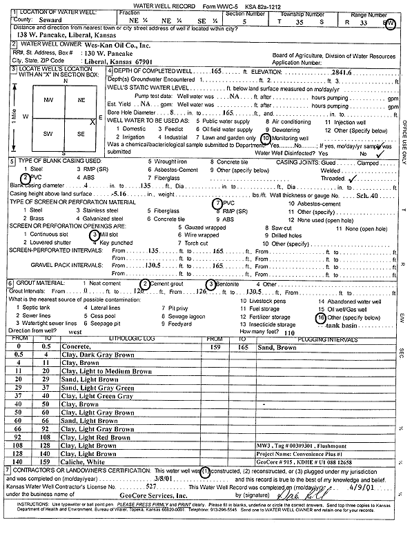
T35S, R33W, Sec. 5 NE NE SE |
Wes-Kan Oil Co., Inc. | 165 ft. | Monitoring well/observation/piezometer | MW 3 | Constructed | 08-Mar-2001 | Scan | ||
|
T35S, R33W, Sec. 5 NW NW NW |
Wes-Kan Oil Co., Inc. | 165 ft. | Monitoring well/observation/piezometer | MW 12 | Constructed | 09-Nov-2004 | |||
|
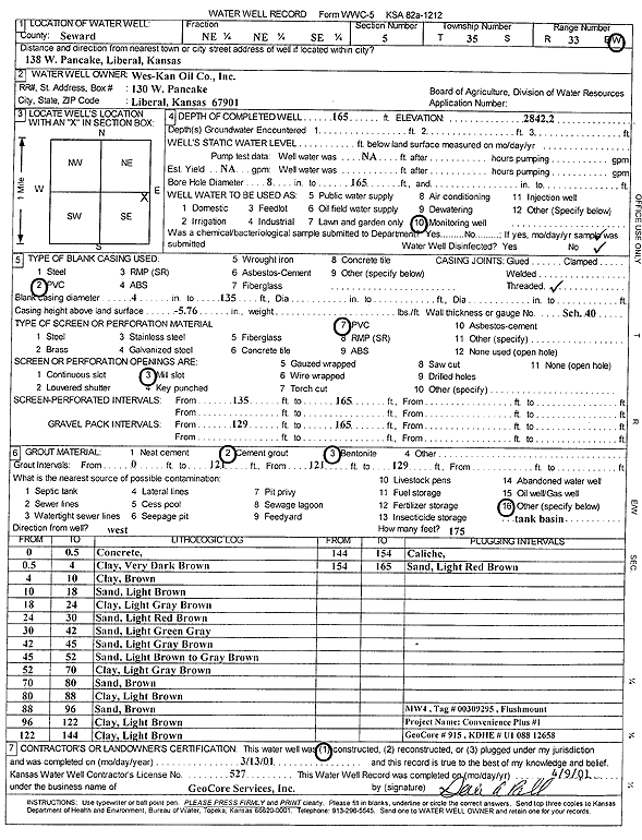
T35S, R33W, Sec. 5 NE NE SE |
Wes-Kan Oil Co., Inc. | 165 ft. | Monitoring well/observation/piezometer | MW 4 | Constructed | 13-Mar-2001 | Scan | ||
|
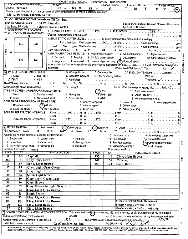
T35S, R33W, Sec. 5 NE NE SE |
Wes-Kan Oil Co., Inc. | 170 ft. | Monitoring well/observation/piezometer | MW 2 | Constructed | 07-Mar-2001 | Scan | ||
|
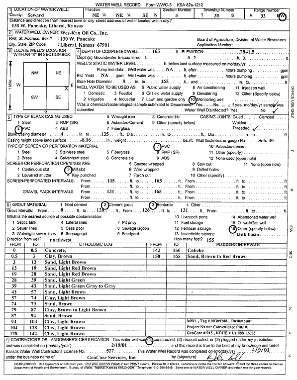
T35S, R33W, Sec. 5 NE NE SE |
Wes-Kan Oil Co., Inc. | 165 ft. | Monitoring well/observation/piezometer | MW 1 | Constructed | 19-Feb-2001 | Scan | ||
|
T35S, R33W, Sec. 6 NE NE NW |
City of Liberal | 145 ft. | 129.06 ft. | Monitoring well/observation/piezometer | MW 4 | Constructed | 11-Feb-1997 | ||
|
T35S, R33W, Sec. 6 NW NW NE |
City of Liberal | 145 ft. | 128.66 ft. | Monitoring well/observation/piezometer | MW 5 | Constructed | 19-Feb-1997 | ||
|
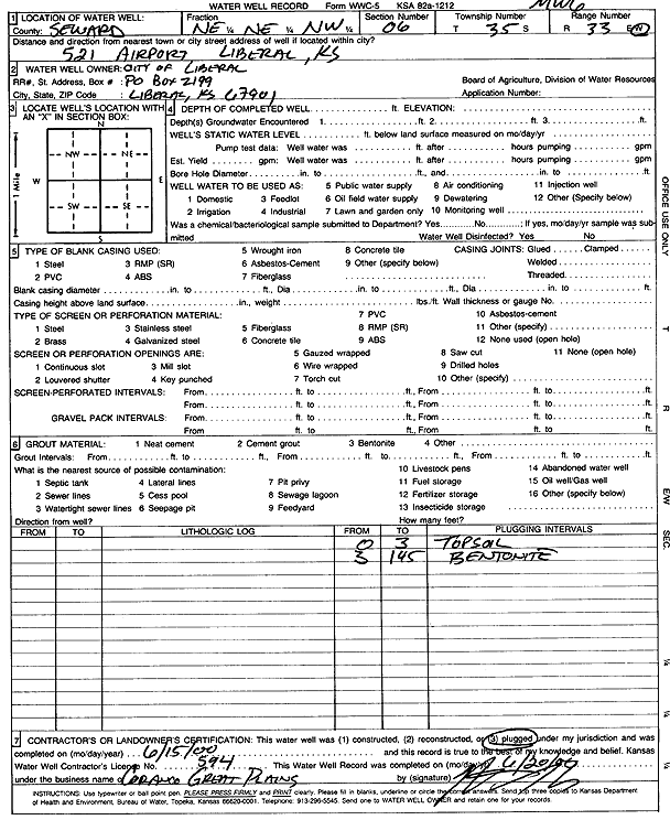
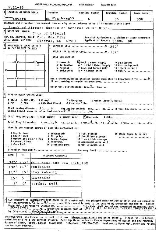
T35S, R33W, Sec. 6 NE SE NW |
City of Liberal | 662 ft. | 140 ft. | Public Water Supply | Constructed | 18-Feb-1999 | Scan | ||
|
T35S, R33W, Sec. 6 NE NE NW |
City of Liberal | 145 ft. | (unstated)/abandoned | MW 6 | Plugged | 15-Jun-2000 | Scan | ||
|
T35S, R33W, Sec. 6 NE NE NW |
City of Liberal | 140 ft. | 128.37 ft. | Monitoring well/observation/piezometer | MW 1 | Constructed | 08-Feb-1997 | ||
|
T35S, R33W, Sec. 6 NE NE NW |
City of Liberal | 145 ft. | 128.97 ft. | Monitoring well/observation/piezometer | MW 2 | Constructed | 11-Feb-1997 | ||
|
T35S, R33W, Sec. 6 NE NE NW |
City of Liberal | 145 ft. | 130.45 ft. | Monitoring well/observation/piezometer | MW 7 | Constructed | 21-Feb-1997 | ||
|
T35S, R33W, Sec. 6 NE NE NW |
City of Liberal | 145 ft. | 127.76 ft. | Monitoring well/observation/piezometer | MW 6 | Constructed | 20-Feb-1997 | ||
|
T35S, R33W, Sec. 6 NE SE NW |
City of Liberal | 560 ft. | 132 ft. | Public Water Supply | Well 26 | Plugged | 09-May-2001 | Scan | |
|
T35S, R33W, Sec. 6 NE NE NW |
City of Liberal | 140 ft. | 129.46 ft. | Monitoring well/observation/piezometer | MW 3 | Constructed | 10-Feb-1997 | ||
| View page: < Prev || 51 || 52 || 53 || 54 || 55 || 56 || 57 || 58 || 59 || 60 | |||||||||