Select location of well to view details.
Click on column heading to sort.
|
|
|
County: Seward Select location of well to view details. Click on column heading to sort. |
|
|
|
| View page: < Prev || 51 || 52 || 53 || 54 || 55 || 56 || 57 || 58 || 59 || 60 | |||||||||
| T-R-S | Owner | Well Depth Ascend. Desc. |
Static Water Level Ascend. Desc. |
Est. Yield Ascend. Desc. |
Well Use | Other ID | Action Taken | Completion Date Ascend. Desc. |
Scan? |
|
T35S, R33W, Sec. 9 NW NW NW |
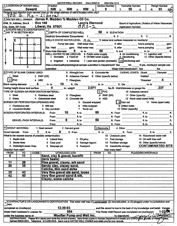
Madden, James R./Madden Oil Co. | 50 ft. | Monitoring well/observation/piezometer | OBS 2 | Constructed | 30-Dec-2003 | Scan | ||
|
T35S, R33W, Sec. 9 NW NW NW |
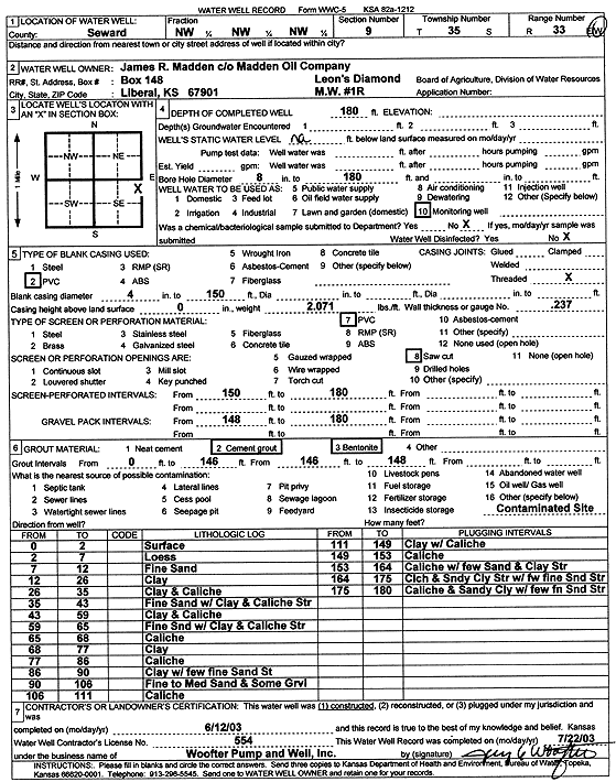
Madden, James R./Madden Oil Co. | 180 ft. | Monitoring well/observation/piezometer | MW 1R | Constructed | 12-Jun-2003 | Scan | ||
|
T35S, R33W, Sec. 9 NW NW NW |
Madden, Jim | 173 ft. | 151 ft. | Monitoring well/observation/piezometer | MW 10 | Constructed | 04-Apr-1995 | ||
|
T35S, R33W, Sec. 9 NW NW NW |
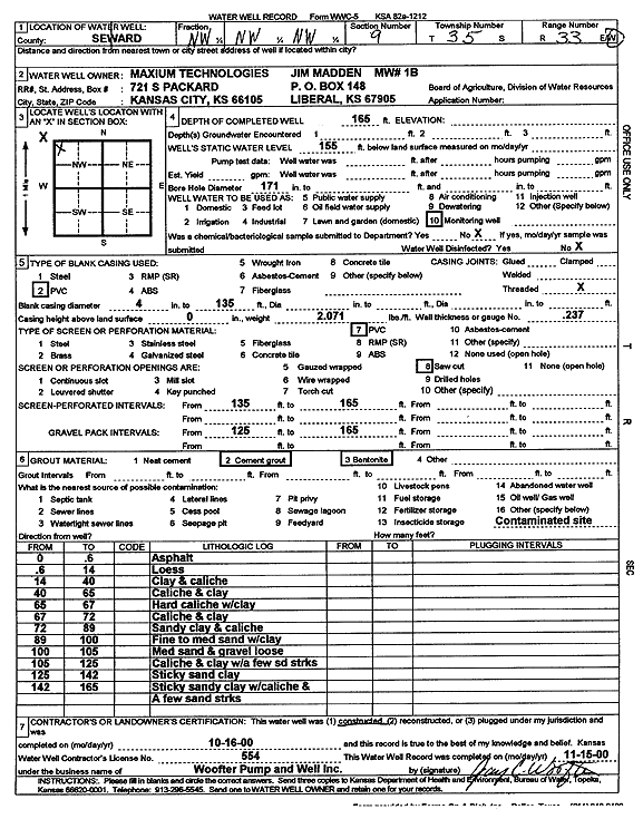
Madden, Jim | 165 ft. | 155 ft. | Monitoring well/observation/piezometer | MW 1 B | Constructed | 16-Oct-2000 | Scan | |
|
T35S, R33W, Sec. 9 NW NW NW |
Madden, Jim | 169 ft. | 151.82 ft. | Monitoring well/observation/piezometer | MW 4 | Constructed | 14-Mar-1995 | ||
|
T35S, R33W, Sec. 9 NW NW NW |
Madden, Jim | 170 ft. | 151.62 ft. | Monitoring well/observation/piezometer | MW 7 | Constructed | 22-Mar-1995 | ||
|
T35S, R33W, Sec. 9 NW NW NW |
Madden, Jim | 169 ft. | 150.44 ft. | Monitoring well/observation/piezometer | MW 5 | Constructed | 14-Mar-1995 | ||
|
T35S, R33W, Sec. 9 NW NW NW |
Madden, Jim | 168 ft. | 151.41 ft. | Monitoring well/observation/piezometer | MW 2 A | Constructed | 24-Feb-1995 | ||
|
T35S, R33W, Sec. 9 NW NW NW |
Madden, Jim | 155 ft. | 151.27 ft. | Monitoring well/observation/piezometer | MW 1 | Constructed | 04-Feb-1995 | ||
|
T35S, R33W, Sec. 9 NW NW NW |
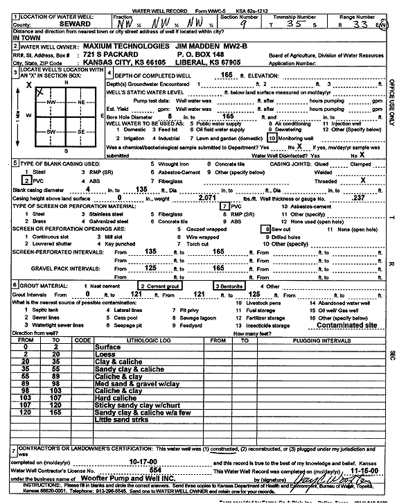
Madden, Jim | 165 ft. | Monitoring well/observation/piezometer | MW 2 B | Constructed | 17-Oct-2000 | Scan | ||
|
T35S, R33W, Sec. 9 NW NW NW |
Madden, Jim | 170 ft. | 150.13 ft. | Monitoring well/observation/piezometer | MW 6 | Constructed | 20-Mar-1995 | ||
|
T35S, R33W, Sec. 9 NW NW NW |
Madden, Jim | 173 ft. | Monitoring well/observation/piezometer | MW 9 | Constructed | 05-Apr-1995 | |||
|
T35S, R33W, Sec. 9 NW NW NW |
Madden, Jim | 171 ft. | 151.11 ft. | Monitoring well/observation/piezometer | MW 8 | Constructed | 30-Mar-1995 | ||
|
T35S, R33W, Sec. 9 NW NW NW |
Madden, Jim | 157 ft. | 151.4 ft. | Monitoring well/observation/piezometer | MW 2 | Plugged | 07-Feb-1995 | ||
|
T35S, R33W, Sec. 9 NW NW NW |
Madden, Jim | 165 ft. | 151 ft. | Monitoring well/observation/piezometer | MW 3 | Constructed | 09-Feb-1995 | ||
|
T35S, R33W, Sec. 9 NW SW SE |
Means, Ed | 285 ft. | 151 ft. | 65 gpm. | Domestic | Leonard McDonald | Constructed | 17-Dec-1997 | |
|
T35S, R33W, Sec. 9 NE NE NE SW |
Sepulveda, Albert | 298 ft. | 175 ft. | 50 gpm. | Domestic | Constructed | 04-Apr-2016 |
KOLAR |
|
|
T35S, R33W, Sec. 10 E2 SE NE |
Anadarko Petroleum Corp | 320 ft. | 145 ft. | 100 gpm. | Oil Field Water Supply | Tobias A 1 | Constructed | 27-Nov-1996 | |
|
T35S, R33W, Sec. 10 NE NW NW SW |
Sizemore, Kenny | 360 ft. | 205 ft. | 70 gpm. | Domestic | Constructed | 14-Sep-2015 |
KOLAR |
|
|
T35S, R33W, Sec. 11 NW |
Zenith Drilling Corp Inc | 300 ft. | 145 ft. | 60 gpm. | Oil Field Water Supply | Howland 2 | Constructed | 02-Sep-1978 | |
|
T35S, R33W, Sec. 12 SE SW SW |
Baray, Tammy | 280 ft. | 172 ft. | 90 gpm. | Domestic | Constructed | 04-Mar-2024 |
KOLAR |
|
|
T35S, R33W, Sec. 12 SW NW NW NE |
Bozarth, Duane | 290 ft. | 180 ft. | 100 gpm. | Domestic | Constructed | 24-May-2018 |
KOLAR |
|
|
T35S, R33W, Sec. 12 C SW SW |
Hill, Don | 240 ft. | 139 ft. | 20 gpm. | Domestic | Constructed | 25-Apr-1979 | ||
|
T35S, R33W, Sec. 13 NE NE |
Warden, Gary | 252 ft. | 140 ft. | 60 gpm. | Domestic | Constructed | 26-Apr-1976 | ||
|
T35S, R33W, Sec. 15 SE SW SE |
Anadarko Petroleum Corp | 340 ft. | 134 ft. | 100 gpm. | Oil Field Water Supply | Schneider Alley 1 | Constructed | 10-Apr-1998 | |
|
T35S, R33W, Sec. 15 SW SW NW |
Slawson Drilling Co. | 305 ft. | 118 ft. | 60 gpm. | Oil Field Water Supply | Schneider E 2 | Constructed | 30-Nov-1982 | |
|
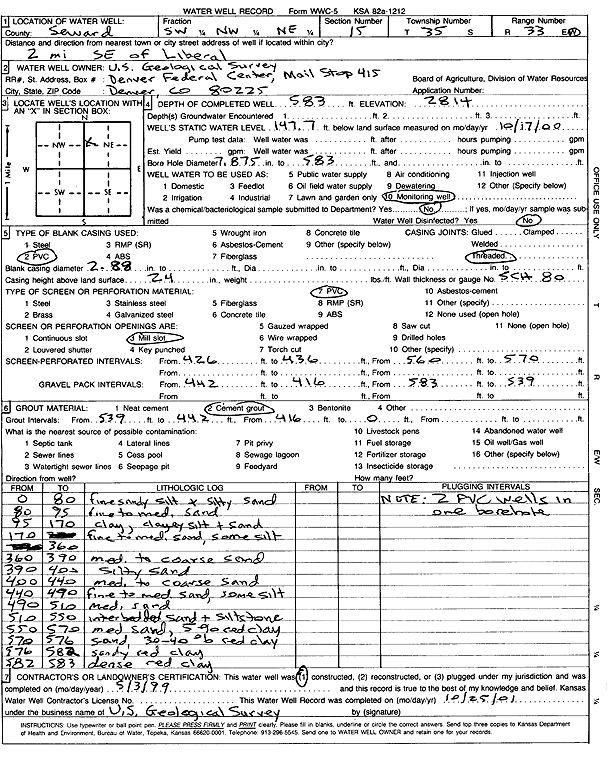
T35S, R33W, Sec. 15 SW NW NE |
U.S. Geological Survey | 583 ft. | 147.7 ft. | Monitoring well/observation/piezometer | Constructed | 03-May-1999 | Scan | ||
|
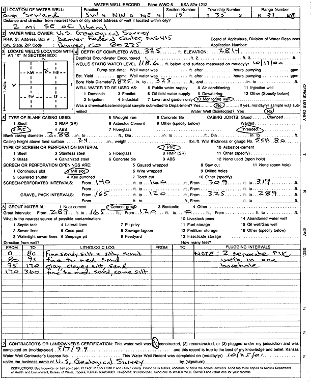
T35S, R33W, Sec. 15 SW NW NE |
U.S. Geological Survey | 325 ft. | 118.6 ft. | Monitoring well/observation/piezometer | Constructed | 07-May-1999 | Scan | ||
|
T35S, R33W, Sec. 16 NW NW SW |
Graber Service | 182.8 ft. | 176.4 ft. | Monitoring well/observation/piezometer | MW 13 | Plugged | 27-Oct-2023 |
KOLAR |
|
|
T35S, R33W, Sec. 16 SW NW NW SW |
Graber Service | 185 ft. | 165 ft. | Monitoring well/observation/piezometer | MW 13 | Constructed | 04-Mar-2013 |
KOLAR |
|
|
T35S, R33W, Sec. 16 NW NW SE |
Larco Inc | 640 ft. | 120 ft. | 1800 gpm. | Irrigation | Constructed | 17-Aug-1976 | ||
|
T35S, R33W, Sec. 16 SE SE SE |
Raydon Exploration Co., Inc. | 300 ft. | 140 ft. | Oil Field Water Supply | 1-16 Kanco | Plugged | 26-Apr-2005 | ||
|
T35S, R33W, Sec. 16 SE SE SE |
Raydon Exploration Co., Inc. | 300 ft. | 140 ft. | 75 gpm. | Oil Field Water Supply | 1-16 Kanco | Constructed | 28-Feb-2005 | |
|
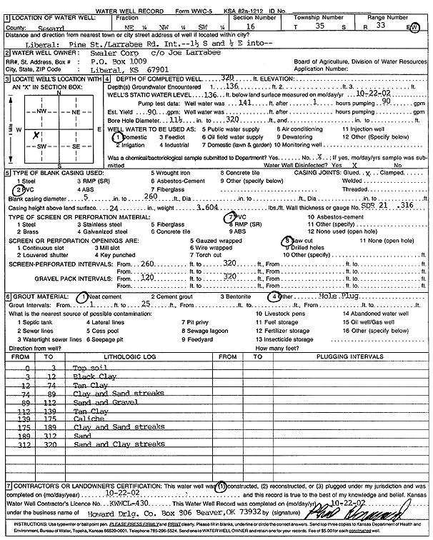
T35S, R33W, Sec. 16 NE NW SW |
Swaler Corp. | 320 ft. | 136 ft. | 90 gpm. | Domestic | Constructed | 22-Oct-2002 | Scan | |
|
T35S, R33W, Sec. 16 NE NE SE |
Zenith Drilling Co Rig 1 | 260 ft. | 130 ft. | 60 gpm. | Oil Field Water Supply | Constructed | 18-Sep-1976 | ||
|
T35S, R33W, Sec. 17 NW NW NE |
Jones, Ralph Jr. | 305 ft. | 153 ft. | 75 gpm. | Oil Field Water Supply | Parson-Jones 2 | Constructed | 25-Apr-1986 | |
|
T35S, R33W, Sec. 18 SE SW |
Unit Drilling Co Rig 1 | 220 ft. | 95 ft. | 45 gpm. | Industrial | McDonald 1 | Constructed | 04-Jul-1975 | |
|
T35S, R33W, Sec. 35 SE NW SW |
Halliburton Energy | 200 ft. | 152.61 ft. | Monitoring well/observation/piezometer | Plugged | 19-Sep-2006 | |||
|
T35S, R34W, Sec. 1 SW SW SW |
Byerley, Mary | 320 ft. | 147 ft. | Domestic | Constructed | 14-Nov-1998 | |||
|
T35S, R34W, Sec. 1 SE NE NW |
City of Liberal/Northern Pump Co | 240 ft. | 109 ft. | 60 gpm. | Oil Field Water Supply | Liberal Airport 7 | Constructed | 01-Nov-1983 | |
|
T35S, R34W, Sec. 1 C SE SW |
Gabbert and Jones | 280 ft. | 105 ft. | Oil Field Water Supply | Plugged | 19-Jul-1985 | |||
|
T35S, R34W, Sec. 1 C SE SW |
Grover, John | 280 ft. | 105 ft. | Oil Field Water Supply | Constructed | 03-Aug-1982 | |||
|
T35S, R34W, Sec. 1 SW NW NE |
Taylor and Associates, Inc | 210 ft. | 35 ft. | Monitoring well/observation/piezometer | Constructed | 10-Apr-2009 | |||
|
T35S, R34W, Sec. 1 SW NW NE |
Taylor and Associates, Inc | 210 ft. | 35 ft. | Monitoring well/observation/piezometer | Constructed | 11-Apr-2009 | |||
|
T35S, R34W, Sec. 2 SW SW NE |
Anadarko Petroleum Corp. | 280 ft. | 100 ft. | 65 gpm. | Oil Field Water Supply | Constructed | 27-Jun-1979 | ||
|
T35S, R34W, Sec. 2 SW NW SE |
Anadarko Petroleum Corp. | 380 ft. | 120 ft. | 120 gpm. | Oil Field Water Supply | 2 Groover B | Constructed | 18-Mar-1998 | |
|
T35S, R34W, Sec. 2 NE NE NE |
Anadarko Petroleum Corp. | 340 ft. | 120 ft. | Oil Field Water Supply | 3 Printz A | Plugged | 27-Feb-1998 | ||
|
T35S, R34W, Sec. 2 SW NE |
Anadarko Petroleum Corp. | 280 ft. | 100 ft. | Oil Field Water Supply | Plugged | 17-Dec-1986 | |||
|
T35S, R34W, Sec. 2 N NE NE |
Anadarko Petroleum Corp. | 340 ft. | 120 ft. | 110 gpm. | Oil Field Water Supply | 3 Printz A | Constructed | 04-Apr-1997 | |
|
T35S, R34W, Sec. 2 NE NE SE SW |
Berry, Gary | 400 ft. | 240 ft. | 70 gpm. | Domestic | Constructed | 15-Apr-2015 |
KOLAR |
|
| View page: < Prev || 51 || 52 || 53 || 54 || 55 || 56 || 57 || 58 || 59 || 60 | |||||||||