Select location of well to view details.
Click on column heading to sort.
|
|
|
County: Seward Select location of well to view details. Click on column heading to sort. |
|
|
|
| View page: < Prev || 51 || 52 || 53 || 54 || 55 || 56 || 57 || 58 || 59 || 60 | |||||||||
| T-R-S | Owner | Well Depth Ascend. Desc. |
Static Water Level Ascend. Desc. |
Est. Yield Ascend. Desc. |
Well Use | Other ID | Action Taken | Completion Date Ascend. Desc. |
Scan? |
|
T35S, R34W, Sec. 11 SE SE SE |
Headrick, Ivan | 306 ft. | 158 ft. | 50 gpm. | Domestic | Constructed | 01-Oct-2012 | ||
|
T35S, R34W, Sec. 11 NE SE SE |
Headrick, Ivan | 280 ft. | 115 ft. | 65 gpm. | Domestic | Constructed | 04-Mar-1985 | ||
|
T35S, R34W, Sec. 12 NE NW SE |
Olinger, Gary/Northern Pump Co | 240 ft. | 110 ft. | 60 gpm. | Oil Field Water Supply | Collingwood 1 | Constructed | 27-Jun-1983 | |
|
T35S, R34W, Sec. 12 SE SE |
Tedford, George | 180 ft. | 105 ft. | 40 gpm. | Domestic | Constructed | 12-Oct-1974 | ||
|
T35S, R34W, Sec. 13 SE SE SE |
Ansley, G. C./Gabbert and Jones | 260 ft. | 88 ft. | Oil Field Water Supply | Plugged | 16-Mar-1988 | |||
|
T35S, R34W, Sec. 13 SE SE SE |
Apsley, Mrs. G. C. | 260 ft. | 95 ft. | 60 gpm. | Oil Field Water Supply | Constructed | 15-Jun-1981 | ||
|
T35S, R34W, Sec. 13 SW NE NW |
Call, Doug | 278 ft. | 107 ft. | 50 gpm. | Domestic | Constructed | 31-Jan-1994 | ||
|
T35S, R34W, Sec. 13 SW NW NW |
Call, Jack | 280 ft. | 120 ft. | 100 gpm. | Domestic | Constructed | 03-Jul-1995 | ||
|
T35S, R34W, Sec. 13 C SW NE |
Call, Jack | 300 ft. | 55 gpm. | Domestic, Lawn and Garden | Constructed | 07-Apr-1989 | |||
|
T35S, R34W, Sec. 13 SW NE NW |
Carlile, Mike | 400 ft. | 200 ft. | 65 gpm. | Domestic | Constructed | 10-Dec-2010 | ||
|
T35S, R34W, Sec. 13 NW NE SW |
Figueroa, Rafael | 320 ft. | 170 ft. | 70 gpm. | Domestic | Constructed | 24-Oct-2023 |
KOLAR |
|
|
T35S, R34W, Sec. 13 SE SW NW |
Ortuno, Manuel | 343 ft. | 169 ft. | 50 gpm. | Domestic | Constructed | 07-Jun-2012 | ||
|
T35S, R34W, Sec. 13 C NE NW |
OW Fuller Estate/Anadarko Production | 280 ft. | 108 ft. | 75 gpm. | Oil Field Water Supply | Fuller C 1 | Constructed | 29-Jan-1985 | |
|
T35S, R34W, Sec. 13 C NE NW |
OW Fuller Estate/Anadarko Production | 280 ft. | 75 ft. | 75 gpm. | Oil Field Water Supply | Fuller C 1 | Plugged | 25-Mar-1985 | |
|
T35S, R34W, Sec. 13 NW SW NE |
Owens, Andrew | 362 ft. | 160 ft. | 50 gpm. | Domestic | Constructed | 07-Aug-2013 | ||
|
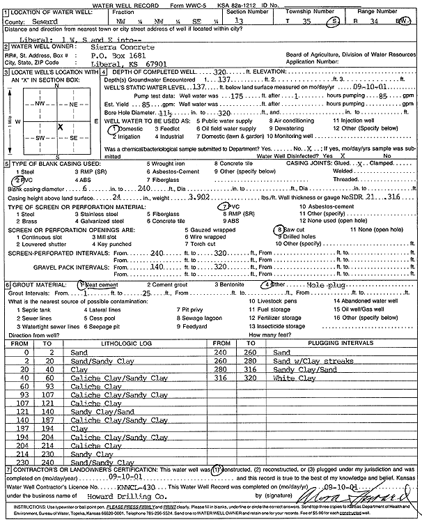
T35S, R34W, Sec. 13 NW NW SE |
Sierra Concrete | 320 ft. | 137 ft. | 85 gpm. | Domestic | Constructed | 10-Sep-2001 | Scan | |
|
T35S, R34W, Sec. 14 SW NE SW |
Anadarko Petroleum Corp. | 280 ft. | 120 ft. | 65 gpm. | Oil Field Water Supply | Fuller B 1 | Constructed | 01-Jun-1981 | |
|
T35S, R34W, Sec. 14 NW NW NW |
Booth, Bill | 240 ft. | 140 ft. | Domestic | Plugged | 01-Aug-2008 | |||
|
T35S, R34W, Sec. 14 NE NW NW |
Booth, Bill | 240 ft. | 140 ft. | Domestic | Plugged | 01-Aug-2008 | |||
|
T35S, R34W, Sec. 14 SE NE NE |
Booth, Bill | 290 ft. | 90 ft. | 200 gpm. | Pond/Swimming Pool/Recreation | Constructed | 19-Aug-1987 | ||
|
T35S, R34W, Sec. 14 SE SE NE |
Booth, William | 420 ft. | Public Water Supply | Constructed | 05-Sep-2007 | ||||
|
T35S, R34W, Sec. 14 C NE SW |
Fuller, M. | 260 ft. | 100 ft. | 70 gpm. | Oil Field Water Supply | Constructed | 25-May-1981 | ||
|
T35S, R34W, Sec. 14 NW SE NE |
Harper, Jim | 237 ft. | 76 ft. | 100 gpm. | Domestic | Constructed | 14-Oct-1977 | ||
|
T35S, R34W, Sec. 14 SE SW NE |
Ivanez, Maday | 175 ft. | 171 ft. | Domestic | Plugged | 21-Feb-2017 | |||
|
T35S, R34W, Sec. 14 SE SW NE |
Ivanez, Maday | 365 ft. | 171 ft. | Domestic | Constructed | 09-Feb-2017 | |||
|
T35S, R34W, Sec. 14 SW SW SW |
Jimmie Rogers Livestock | 340 ft. | 120 ft. | Domestic | Plugged | 03-Nov-2007 | |||
|
T35S, R34W, Sec. 14 SW SW SW |
Jimmie Rogers Livestock | 300 ft. | 120 ft. | Domestic | Plugged | 03-Nov-2007 | |||
|
T35S, R34W, Sec. 14 SW NE NE |
Jimmie Rogers Trucking | 340 ft. | 140 ft. | 70 gpm. | Domestic | Constructed | 28-Sep-2009 | ||
|
T35S, R34W, Sec. 14 NE NE SE |
Max Jantz Excavating LLC | 242 ft. | 112 ft. | Domestic | Plugged | 16-Oct-2006 | |||
|
T35S, R34W, Sec. 14 NE NE SE |
Max Jantz Excavating LLC | 440 ft. | 130 ft. | 100 gpm. | Road Construction | Well 1 | Constructed | 09-May-2006 | |
|
T35S, R34W, Sec. 14 NE NE SE |
Max Jantz Excavating LLC | 248 ft. | 116 ft. | Domestic | Plugged | 16-Oct-2006 | |||
|
T35S, R34W, Sec. 14 NE NE SE |
Max Jantz Excavating LLC | 420 ft. | 120 ft. | 185 gpm. | Road Construction | Well 2 | Constructed | 28-Apr-2006 | |
|
T35S, R34W, Sec. 14 NE NE NE |
Mead, Mrs, F.E. | 250 ft. | 135 ft. | Domestic | Constructed | 19-Dec-1977 | |||
|
T35S, R34W, Sec. 14 NE NE SW |
Purvis and Rogers | 240 ft. | 88 ft. | 30 gpm. | Domestic | Constructed | 05-Apr-1976 | ||
|
T35S, R34W, Sec. 14 NE NE SW |
Purvis and Rogers | 260 ft. | 88 ft. | 380 gpm. | Industrial | Constructed | 05-Apr-1976 | ||
|
T35S, R34W, Sec. 14 SE NW NE |
Wessell, Pete | 240 ft. | 78 ft. | 50 gpm. | Domestic | Constructed | 27-Aug-1975 | ||
|
T35S, R34W, Sec. 15 C NE NE |
Anadarko Petroleum Corp. | 340 ft. | 204 ft. | 100 gpm. | Oil Field Water Supply | 2 D Boles | Constructed | 08-Sep-1997 | |
|
T35S, R34W, Sec. 16 SW SW SW |
H-30 Drilling, Inc. | 320 ft. | 170 ft. | 90 gpm. | Oil Field Water Supply | 1-16 Boles | Constructed | 28-Dec-1990 | |
|
T35S, R34W, Sec. 16 NE NW |
Sage Drlg Co | 260 ft. | 80 ft. | 80 gpm. | Oil Field Water Supply | Constructed | 20-Sep-1978 | ||
|
T35S, R34W, Sec. 17 C SW NE |
Grover, John/Johnson Drlg | 307 ft. | 98 ft. | 100 gpm. | Oil Field Water Supply | Grover D 1 | Plugged | 08-Oct-1985 | |
|
T35S, R34W, Sec. 17 C SW NE |
Grover, John/Johnson Drlg | 307 ft. | 98 ft. | 100 gpm. | Oil Field Water Supply | Grover D 1 | Constructed | 11-Sep-1985 | |
|
T35S, R34W, Sec. 17 C NE NW |
Oyler, Lloyd/ Flynn Energy | 280 ft. | 123 ft. | 60 gpm. | Oil Field Water Supply | Oyler 17-1 | Constructed | 24-Apr-1984 | |
|
T35S, R34W, Sec. 17 SW SW SW |
Oyler, Lloyd/Flynn Energy | 280 ft. | 95 ft. | 70 gpm. | Oil Field Water Supply | Constructed | 12-Jan-1985 | ||
|
T35S, R34W, Sec. 18 SW SW SW |
H-30 Drilling, Inc. | 260 ft. | 110 ft. | 60 gpm. | Oil Field Water Supply | Dowdy 1 | Constructed | 02-Oct-1987 | |
| View page: < Prev || 51 || 52 || 53 || 54 || 55 || 56 || 57 || 58 || 59 || 60 | |||||||||