Select location of well to view details.
Click on column heading to sort.
|
|
|
County: Shawnee Select location of well to view details. Click on column heading to sort. |
|
|
|
| View page: < Prev || 71 || 72 || 73 || 74 || 75 || 76 || 77 || 78 || 79 || 80 || Next > | |||||||||
| T-R-S | Owner | Well Depth Ascend. Desc. |
Static Water Level Ascend. Desc. |
Est. Yield Ascend. Desc. |
Well Use | Other ID | Action Taken | Completion Date Ascend. Desc. |
Scan? |
|
T12S, R15E, Sec. 36 NE SE SE NE |
Lindemuth Inc (Pauline Farm) | 6.85 ft. | 2.26 ft. | Monitoring well/observation/piezometer | NMW 2 S | Plugged | 24-Apr-2023 | ||
|
T12S, R15E, Sec. 36 SE NE SE NE |
Lindemuth Inc (Pauline Farm) | 5.81 ft. | 1.68 ft. | Monitoring well/observation/piezometer | NMW 3 S | Plugged | 25-Apr-2023 | ||
|
T12S, R15E, Sec. 36 NE SE SE NE |
Lindemuth Inc (Pauline Farm) | 12.75 ft. | 2.37 ft. | Monitoring well/observation/piezometer | NMW 2 D | Plugged | 24-Apr-2023 | ||
|
T12S, R15E, Sec. 36 NE SE SE NE |
Lindemuth Inc (Pauline Farm) | 18.02 ft. | 2.65 ft. | Monitoring well/observation/piezometer | NMW 23 | Plugged | 25-Apr-2023 | ||
|
T12S, R15E, Sec. 36 SE NE SE NE |
Lindemuth Inc (Pauline Farm) | 19.73 ft. | 2.84 ft. | Monitoring well/observation/piezometer | NMW 25 | Plugged | 25-Apr-2023 | ||
|
T12S, R15E, Sec. 36 NE SE NE |
Lindemuth, Inc (Pauline Farm Store) | 5 ft. | 4.7 ft. | Monitoring well/observation/piezometer | NMW 6 S | Constructed | 23-Sep-2009 | ||
|
T12S, R15E, Sec. 36 NE SE NE |
Lindemuth, Inc (Pauline Farm Store) | 14 ft. | 2.4 ft. | Monitoring well/observation/piezometer | NMW 9 | Constructed | 22-Sep-2009 | ||
|
T12S, R15E, Sec. 36 NE SE NE |
Lindemuth, Inc (Pauline Farm Store) | 11 ft. | 3.34 ft. | Monitoring well/observation/piezometer | NMW 7 | Constructed | 23-Sep-2009 | ||
|
T12S, R15E, Sec. 36 SE NE NE |
Lindemuth, Inc (Pauline Farm Store) | 14 ft. | 4.45 ft. | Monitoring well/observation/piezometer | NMW 10 | Constructed | 22-Sep-2009 | ||
|
T12S, R15E, Sec. 36 NE SE NE |
Lindemuth, Inc (Pauline Farm Store) | 9 ft. | 3.4 ft. | Monitoring well/observation/piezometer | NMW 6 D | Constructed | 23-Sep-2009 | ||
|
T12S, R15E, Sec. 36 SE SE NE |
Lindemuth, Inc (Pauline Farm Store) | 12 ft. | 5.8 ft. | Monitoring well/observation/piezometer | NMW 1 | Constructed | 22-Sep-2009 | ||
|
T12S, R15E, Sec. 36 NE SE NE |
Lindemuth, Inc (Pauline Farm Store) | 11 ft. | 2.84 ft. | Monitoring well/observation/piezometer | NMW 5 | Constructed | 23-Sep-2009 | ||
|
T12S, R15E, Sec. 36 NE SE NE |
Lindemuth, Inc (Pauline Farm Store) | 6 ft. | 5.1 ft. | Monitoring well/observation/piezometer | NMW 4 | Constructed | 22-Sep-2009 | ||
|
T12S, R15E, Sec. 36 SE SE NE |
Lindemuth, Inc (Pauline Farm Store) | 7 ft. | 2.98 ft. | Monitoring well/observation/piezometer | NMW 2 S | Constructed | 22-Sep-2009 | ||
|
T12S, R15E, Sec. 36 NE SE NE |
Lindemuth, Inc (Pauline Farm Store) | 11 ft. | 1.93 ft. | Monitoring well/observation/piezometer | NMW 3 D | Constructed | 23-Sep-2009 | ||
|
T12S, R15E, Sec. 36 NE SE NE |
Lindemuth, Inc (Pauline Farm Store) | 12 ft. | 4.67 ft. | Monitoring well/observation/piezometer | NMW 8 | Constructed | 23-Sep-2009 | ||
|
T12S, R15E, Sec. 36 NE SE NE |
Lindemuth, Inc (Pauline Farm Store) | 5.9 ft. | 3.45 ft. | Monitoring well/observation/piezometer | NMW 3 S | Constructed | 22-Sep-2009 | ||
|
T12S, R15E, Sec. 36 SE SE NE |
Lindemuth, Inc (Pauline Farm Store) | 12.5 ft. | 3 ft. | Monitoring well/observation/piezometer | NMW 2 D | Constructed | 23-Sep-2009 | ||
|
T12S, R15E, Sec. 36 SE NE NE |
Lindemuth, Inc/Pauline Farm Store | 17.5 ft. | 4.95 ft. | Monitoring well/observation/piezometer | NMW 12 | Constructed | 21-Oct-2010 | ||
|
T12S, R15E, Sec. 36 SE NE NE |
Lindemuth, Inc/Pauline Farm Store | 18 ft. | 7.77 ft. | Monitoring well/observation/piezometer | NMW 11 | Constructed | 21-Oct-2010 | ||
|
T12S, R15E, Sec. 36 SE SE NE |
Pauline Farmers Coop | 13 ft. | 9.74 ft. | Monitoring well/observation/piezometer | well 6 | Constructed | 18-Feb-1998 | ||
|
T12S, R15E, Sec. 36 SE SE NE |
Pauline Farmers Coop | 12.5 ft. | 4.91 ft. | Monitoring well/observation/piezometer | well 5 | Constructed | 19-Feb-1998 | ||
|
T12S, R15E, Sec. 36 SE SE NE |
Pauline Farmers Coop | 10.5 ft. | 4.23 ft. | Monitoring well/observation/piezometer | Constructed | 19-Feb-1998 | |||
|
T12S, R15E, Sec. 36 NE NE SE |
Pauline Farmers Coop | 13.5 ft. | 6.7 ft. | Monitoring well/observation/piezometer | well 3 | Constructed | 20-Feb-1998 | ||
|
T12S, R15E, Sec. 36 SE SE NE |
Pauline Farmers Coop | 13.6 ft. | 11.08 ft. | Monitoring well/observation/piezometer | well 7 | Constructed | 18-Feb-1998 | ||
|
T12S, R15E, Sec. 36 SE SE NE |
Pauline Farmers Coop | 12.6 ft. | 5.7 ft. | Monitoring well/observation/piezometer | well 4 | Constructed | 18-Feb-1998 | ||
|
T12S, R15E, Sec. 36 SE SE NE |
Pauline Farmers Coop | 14 ft. | 12.3 ft. | Monitoring well/observation/piezometer | well 2 | Constructed | 18-Feb-1998 | ||
|
T12S, R15E, Sec. 36 SE SE NE |
Pauline Farmers Coop | 10.5 ft. | 5.27 ft. | Monitoring well/observation/piezometer | well 8 | Constructed | 19-Feb-1998 | ||
|
T12S, R15E, Sec. 36 SE SE NE |
Pauline Farmers Coop | 11 ft. | 5.05 ft. | Monitoring well/observation/piezometer | well 10 | Constructed | 20-Feb-1998 | ||
|
T12S, R15E, Sec. 36 SE SE NE |
Pauline Farmers Coop | 13.6 ft. | 5 ft. | Monitoring well/observation/piezometer | Constructed | 18-Feb-1998 | |||
|
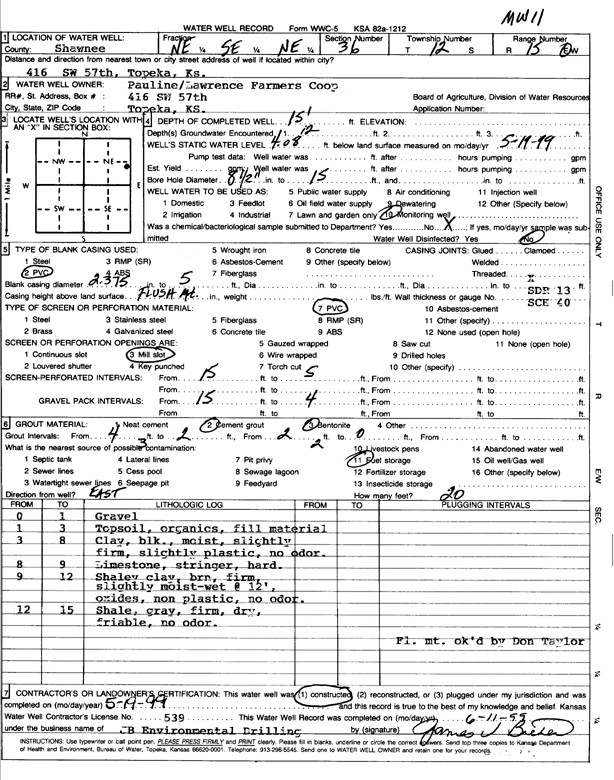
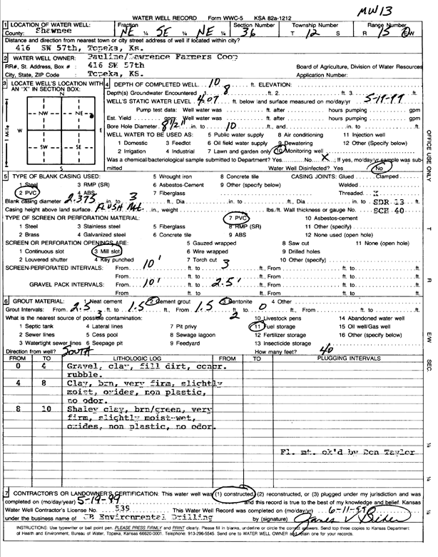
T12S, R15E, Sec. 36 NE SE NE |
Pauline/Lawrence Farmers Coop | 15 ft. | 4.08 ft. | Monitoring well/observation/piezometer | MW 11 | Constructed | 19-May-1999 | Scan | |
|
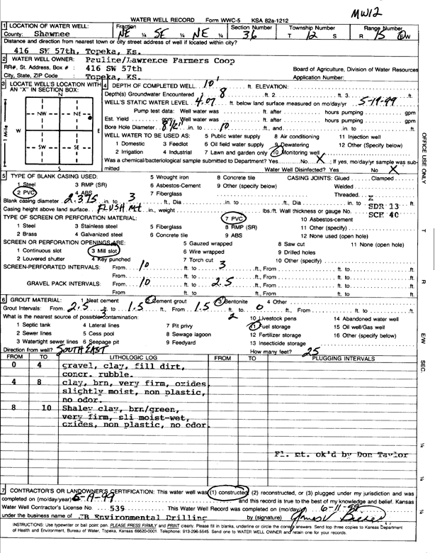
T12S, R15E, Sec. 36 NE SE NE |
Pauline/Lawrence Farmers Coop | 10 ft. | 4.07 ft. | Monitoring well/observation/piezometer | MW 12 | Constructed | 19-May-1999 | Scan | |
|
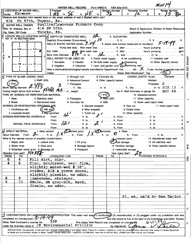
T12S, R15E, Sec. 36 NE SE NE |
Pauline/Lawrence Farmers Coop | 12 ft. | 3.04 ft. | Monitoring well/observation/piezometer | MW 14 | Constructed | 19-May-1999 | Scan | |
|
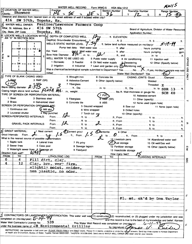
T12S, R15E, Sec. 36 NE SE NE |
Pauline/Lawrence Farmers Coop | 12 ft. | 7.34 ft. | Monitoring well/observation/piezometer | MW 15 | Constructed | 19-May-1999 | Scan | |
|
T12S, R15E, Sec. 36 NE SE NE |
Pauline/Lawrence Farmers Coop | 10 ft. | 4.07 ft. | Monitoring well/observation/piezometer | MW 13 | Constructed | 19-May-1999 | Scan | |
|
T12S, R16E, Sec. 1 SE SE NW |
Besler, John A. | 58 ft. | 26 ft. | 5 gpm. | Domestic | Constructed | 11-Oct-1984 | ||
|
T12S, R16E, Sec. 1 C S2 S2 S2 |
Kansas Dept. of Transportation, KDOT | 48.2 ft. | Test Hole, Geotechnical | 004-089 K-6252-01 | Constructed | 15-Aug-1996 | |||
|
T12S, R16E, Sec. 1 NW NW |
Kansas Dept. of Transportation, KDOT | 43.1 ft. | Test Hole, Geotechnical | 40-89 K-2386-01 | Constructed | 17-Jul-1989 | |||
|
T12S, R16E, Sec. 2 SW NE NE SW |
Kansas Dept. of Transportation, KDOT | 42 ft. | Test Hole, Geotechnical | 004-089 K-6252-01 | Constructed | 08-Aug-1996 | |||
|
T12S, R16E, Sec. 2 S2 NE NW SW |
Kansas Dept. of Transportation, KDOT | 67.2 ft. | Test Hole, Geotechnical | K-6252-01 | Constructed | 09-Jun-1997 | |||
|
T12S, R16E, Sec. 2 SW SW NW SW |
Kansas Dept. of Transportation, KDOT | 76.9 ft. | Test Hole, Geotechnical | K-6252-01 | Constructed | 14-May-1997 | |||
|
T12S, R16E, Sec. 2 NW SW SW SW |
Kansas Dept. of Transportation, KDOT | 32.9 ft. | Test Hole, Geotechnical | 004-089 K-6252-01 | Constructed | 28-May-1997 | |||
|
T12S, R16E, Sec. 2 NE SE NW SW |
Kansas Dept. of Transportation, KDOT | 52.1 ft. | Test Hole, Geotechnical | 004-089 K-6252-01 | Constructed | 07-Aug-1996 | |||
|
T12S, R16E, Sec. 2 SW NW NW SW |
Kansas Dept. of Transportation, KDOT | 53.1 ft. | Test Hole, Geotechnical | K-6252-01 | Constructed | 12-May-1997 | |||
|
T12S, R16E, Sec. 2 SE NW SW |
Kansas Dept. of Transportation, KDOT | 31 ft. | Test Hole, Geotechnical | K-6252-01 | Constructed | 14-Aug-1996 | |||
|
T12S, R16E, Sec. 3 SW |
Kansas Dept. of Transportation, KDOT | 57.5 ft. | Test Hole, Geotechnical | 004-089 K-3362-03 | Constructed | 16-May-1994 | |||
|
T12S, R16E, Sec. 3 SW |
Kansas Dept. of Transportation, KDOT | 79 ft. | Test Hole, Geotechnical | 004-089 K-3362-03 | Constructed | 13-May-1993 | |||
|
T12S, R16E, Sec. 3 S2 N2 S2 |
Kansas Dept. of Transportation, KDOT | 57.8 ft. | Test Hole, Geotechnical | K-3362-03 | Constructed | 14-Mar-1994 | |||
|
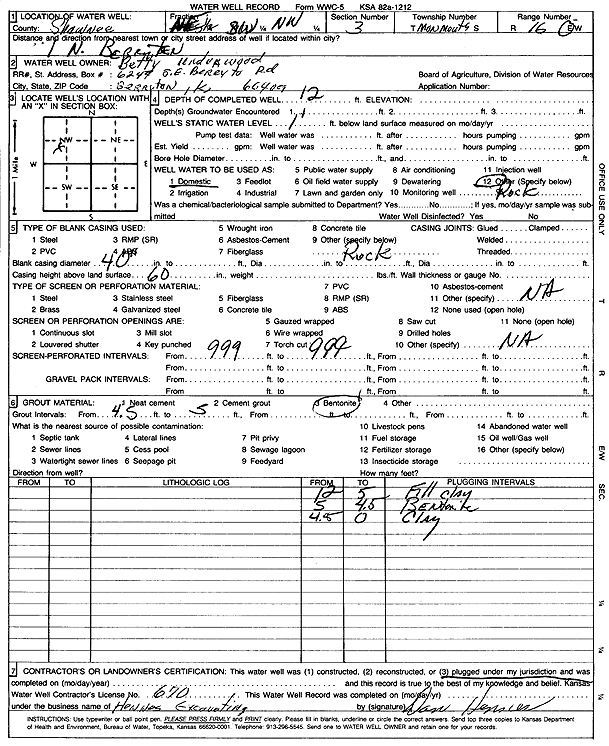
T12S, R16E, Sec. 3 NE SW NW |
Underwood, Betty | 12 ft. | 1 ft. | Domestic | Plugged | Scan | |||
|
T12S, R16E, Sec. 3 SW SW SE |
YRC Worldwide Enterprise | 16.8 ft. | 4.9 ft. | Monitoring well/observation/piezometer | MW 2 | Constructed | 08-May-2007 | ||
| View page: < Prev || 71 || 72 || 73 || 74 || 75 || 76 || 77 || 78 || 79 || 80 || Next > | |||||||||