Select location of well to view details.
Click on column heading to sort.
|
|
|
County: Stanton Select location of well to view details. Click on column heading to sort. |
|
|
|
| View page: < Prev || 11 || 12 || 13 || 14 || 15 || 16 || 17 || 18 || 19 || 20 || Next > | |||||||||
| T-R-S | Owner | Well Depth Ascend. Desc. |
Static Water Level Ascend. Desc. |
Est. Yield Ascend. Desc. |
Well Use | Other ID | Action Taken | Completion Date Ascend. Desc. |
Scan? |
|
T29S, R40W, Sec. 4 SE NE SW NE |
Zortman, Duane and Becky | 612 ft. | 420 ft. | 75 gpm. | Domestic, Livestock | Constructed | 30-Jun-2019 |
KOLAR |
|
|
T29S, R40W, Sec. 5 NW SW |
Arnold, Earl | 400 ft. | Irrigation | Plugged | 31-Mar-2011 | ||||
|
T29S, R40W, Sec. 5 SE SE NE NE |
Cordero, Pablo | 598 ft. | 390 ft. | 40 gpm. | Domestic | Constructed | 05-Nov-2015 |
KOLAR |
|
|
T29S, R40W, Sec. 5 NE NE NW |
Grover, Ron | 587 ft. | 332 ft. | Irrigation | Constructed | 13-Apr-2004 | Scan | ||
|
T29S, R40W, Sec. 6 SW SW SW SE |
Arnold, Earl | 560 ft. | 380 ft. | 20 gpm. | Domestic | Constructed | 11-Sep-2015 |
KOLAR |
|
|
T29S, R40W, Sec. 6 SW SW SW SE |
Arnold, Earl | 96 ft. | Domestic | Plugged | 12-Sep-2015 |
KOLAR |
|||
|
T29S, R40W, Sec. 6 NW NW SE |
Arnold, Earl | 400 ft. | Irrigation | Plugged | 31-Mar-2011 | ||||
|
T29S, R40W, Sec. 6 SW SW SW SE |
Arnold, Earl | 399 ft. | 398 ft. | Domestic | Plugged | 12-Sep-2015 |
KOLAR |
||
|
T29S, R40W, Sec. 6 SW SW NW |
Grover, Ron | 350 ft. | 315 ft. | Irrigation | Plugged | 29-Mar-1994 | |||
|
T29S, R40W, Sec. 6 SW SW NW |
Grover, Ronald | 564 ft. | 315 ft. | 1000 gpm. | Irrigation | Constructed | 26-Jan-1994 | ||
|
T29S, R40W, Sec. 7 NW NE SW |
Murfin Drilling/Keith Gasgill | 379 ft. | 297 ft. | Oil Field Water Supply | Constructed | 23-May-1994 | |||
|
T29S, R40W, Sec. 7 NW NE SW |
Murfin Drilling/Keith Gasgill | 379 ft. | Oil Field Water Supply | Plugged | 06-Jun-1994 | ||||
|
T29S, R40W, Sec. 8 SW NW NE |
Peterson, Brant | 593 ft. | 350 ft. | Domestic, Livestock | Constructed | 16-Dec-2009 | |||
|
T29S, R40W, Sec. 9 NE NE NE SW |
Winger, Melvin | 584 ft. | 334 ft. | Irrigation | Constructed | 19-Jan-2008 | |||
|
T29S, R40W, Sec. 10 SE |
John Nelson Freedom Farms | 371 ft. | Irrigation | Plugged | 13-Mar-2013 | ||||
|
T29S, R40W, Sec. 10 SW NW NW SE |
Nelson, John | 595 ft. | 360 ft. | 598 gpm. | Irrigation | Constructed | 06-Dec-2012 |
KOLAR |
|
|
T29S, R40W, Sec. 11 NE NE NE NW |
H & C Farms | 585 ft. | 355 ft. | 941 gpm. | Irrigation | Constructed | 11-Apr-2012 |
KOLAR |
|
|
T29S, R40W, Sec. 12 C SE NE |
Hugoton Energy | 360 ft. | 200 ft. | 100 gpm. | Oil Field Water Supply | Westwind 1-12 | Constructed | 13-Jun-1994 | |
|
T29S, R40W, Sec. 13 SW SW SE |
Collingwood, Dr. Al | 616 ft. | 376 ft. | 400 gpm. | Irrigation | Constructed | 29-Sep-2023 |
KOLAR |
|
|
T29S, R40W, Sec. 13 NW SE NW |
Julian, Basil | 460 ft. | 167 ft. | 1250 gpm. | Irrigation | Constructed | 29-Feb-1976 | ||
|
T29S, R40W, Sec. 14 NW NW NW SW |
Collingwood Farms LLC | 559 ft. | 362 ft. | 410 gpm. | Irrigation | Constructed | 18-Mar-2015 |
KOLAR |
|
|
T29S, R40W, Sec. 15 NW NW SW |
Collingwood, Al | 550 ft. | Domestic | Constructed | 29-Jun-2012 | ||||
|
T29S, R40W, Sec. 15 NE SE SW |
Collingwood, Alfred J. | 532 ft. | 291 ft. | Irrigation | Constructed | 20-Feb-1999 | Scan | ||
|
T29S, R40W, Sec. 15 SE NW SE |
Mitchell, Dwight | 477 ft. | 186 ft. | 1400 gpm. | Irrigation | Constructed | 31-Mar-1976 | ||
|
T29S, R40W, Sec. 16 SW NW NW SW |
Martin, Janet | 377 ft. | 375 ft. | Domestic | Plugged | 23-Jul-2016 |
KOLAR |
||
|
T29S, R40W, Sec. 16 SW NW NW SW |
Martin, Janet | 575 ft. | 375 ft. | 30 gpm. | Domestic | Constructed | 22-Jul-2016 |
KOLAR |
|
|
T29S, R40W, Sec. 16 SW SW NE |
Martin, Robert | 518 ft. | 176 ft. | 2000 gpm. | Irrigation | Constructed | 02-Sep-1976 | ||
|
T29S, R40W, Sec. 16 NW NW SE |
Martin, Robert D. and Janet | 608 ft. | 378 ft. | 500 gpm. | Irrigation | Constructed | 18-Oct-2023 |
KOLAR |
|
|
T29S, R40W, Sec. 18 NE NW NW |
Becker Oil | 460 ft. | 235 ft. | 100 gpm. | Oil Field Water Supply | Esser 1 | Constructed | 13-Feb-1996 | |
|
T29S, R40W, Sec. 18 SE NW |
Garey, Melvin | 495 ft. | 200 ft. | Irrigation | Constructed | 30-Nov-1977 | |||
|
T29S, R40W, Sec. 18 SE SE NE NW |
Nelson, Seth | 632 ft. | 320 ft. | 250 gpm. | Irrigation | Constructed | 19-Jun-2015 |
KOLAR |
|
|
T29S, R40W, Sec. 21 NE NW NE SW |
4 Leaf Clover Farms LTD | 591 ft. | 364 ft. | 903 gpm. | Irrigation | Constructed | 20-Aug-2020 |
KOLAR |
|
|
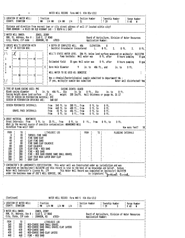
T29S, R40W, Sec. 21 NW NW NW |
Jones, Jerry | 486 ft. | 284 ft. | 35 gpm. | Domestic | Constructed | 18-Jun-1998 | Scan | |
|
T29S, R40W, Sec. 22 NE NE SW |
Seyb, Bill | 518 ft. | 205 ft. | 2500 gpm. | Irrigation | Constructed | 20-May-1978 | ||
|
T29S, R40W, Sec. 25 NE NE NW |
Nordling, Leland | 517.3 ft. | 168 ft. | 1218 gpm. | Irrigation | Constructed | 05-Jan-1977 | ||
|
T29S, R40W, Sec. 25 SW NW NW NE |
Swede Acre LLC | 552 ft. | 340 ft. | 903 gpm. | Irrigation | Constructed | 06-May-2015 |
KOLAR |
|
|
T29S, R40W, Sec. 25 SE SE |
Whipple, Judy | 420 ft. | 294 ft. | Domestic | Constructed | 13-Jun-2008 | |||
|
T29S, R40W, Sec. 25 SE SE SE |
Whipple, Judy | 500 ft. | 366 ft. | 15 gpm. | Domestic | Constructed | 03-Apr-2026 |
KOLAR |
|
|
T29S, R40W, Sec. 25 SW SW SW SE |
Whipple, Judy and Leo | 578 ft. | 336 ft. | 964 gpm. | Irrigation | Constructed | 19-Sep-2018 |
KOLAR |
|
|
T29S, R40W, Sec. 26 NE NW NW |
Jones, Jerry | 300 ft. | 175 ft. | 10 gpm. | Domestic | Constructed | 20-Jun-1975 | ||
|
T29S, R40W, Sec. 26 NW NE NW |
Jones, Jerry L. and Sandra L. | 535 ft. | 310 ft. | Irrigation | Constructed | 21-Mar-2008 | |||
|
T29S, R40W, Sec. 28 NW NW NE |
4 Leaf Clover Farms LTD | 570 ft. | 358 ft. | Irrigation | Constructed | 05-May-2022 |
KOLAR |
||
|
T29S, R40W, Sec. 28 NW NW NW |
Shepard, Steve | 540 ft. | 352 ft. | 25 gpm. | Domestic | Constructed | 26-Nov-2025 |
KOLAR |
|
|
T29S, R40W, Sec. 30 NW NW NW NE |
Floyd, Chris | 480 ft. | 325 ft. | 20 gpm. | Domestic, Livestock | Constructed | 30-Sep-2020 | ||
|
T29S, R40W, Sec. 33 SE SW SW |
Josserand, Pat | 601 ft. | 352 ft. | 450 gpm. | Irrigation | Constructed | 03-May-2023 |
KOLAR |
|
|
T29S, R40W, Sec. 33 SE SE SW |
Morris, Mearl | 415 ft. | 305 ft. | Domestic | Constructed | 05-Aug-1998 | |||
|
T29S, R40W, Sec. 33 NE NE NE |
Teeter, Harry | 375 ft. | 195 ft. | Domestic | Constructed | 05-May-1982 | |||
|
T29S, R40W, Sec. 34 NE NE SW |
Dye, William H. | 500 ft. | 165 ft. | 1300 gpm. | Irrigation | Constructed | 02-Sep-1976 | ||
|
T29S, R40W, Sec. 34 NW |
Teeter, Glenn | 342 ft. | 320 ft. | Irrigation | Plugged | 01-May-2007 | |||
|
T29S, R40W, Sec. 34 NE NW NW |
Teeter, Mytrle | 375 ft. | 260 ft. | Irrigation | Constructed | 25-Aug-1998 | |||
| View page: < Prev || 11 || 12 || 13 || 14 || 15 || 16 || 17 || 18 || 19 || 20 || Next > | |||||||||