Select location of well to view details.
Click on column heading to sort.
|
|
|
County: Stanton Select location of well to view details. Click on column heading to sort. |
|
|
|
| View page: < Prev || 11 || 12 || 13 || 14 || 15 || 16 || 17 || 18 || 19 || 20 || Next > | |||||||||
| T-R-S | Owner | Well Depth Ascend. Desc. |
Static Water Level Ascend. Desc. |
Est. Yield Ascend. Desc. |
Well Use | Other ID | Action Taken | Completion Date Ascend. Desc. |
Scan? |
|
T29S, R42W, Sec. 14 NE SE SW |
Johnson Coop Grain | 85.1 ft. | Environmental Remediation, Air Sparge | ASW 3 J | Plugged | 02-Sep-2009 | |||
|
T29S, R42W, Sec. 14 SE SW SW |
Johnson Coop Grain | 83.3 ft. | Environmental Remediation, Air Sparge | ASW | Plugged | 02-Sep-2009 | |||
|
T29S, R42W, Sec. 14 NW SE SW |
Johnson Coop Grain | 89 ft. | 75.27 ft. | Monitoring well/observation/piezometer | MW 16 | Constructed | 06-Dec-1996 | ||
|
T29S, R42W, Sec. 14 NE SW SW |
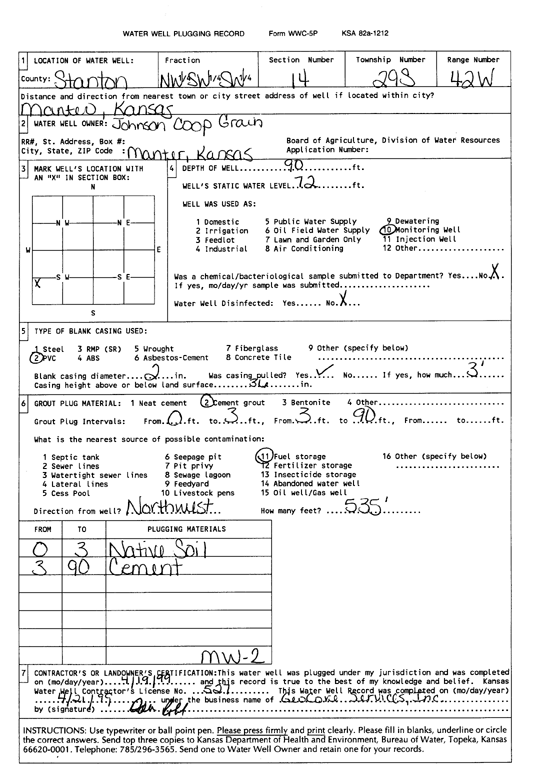
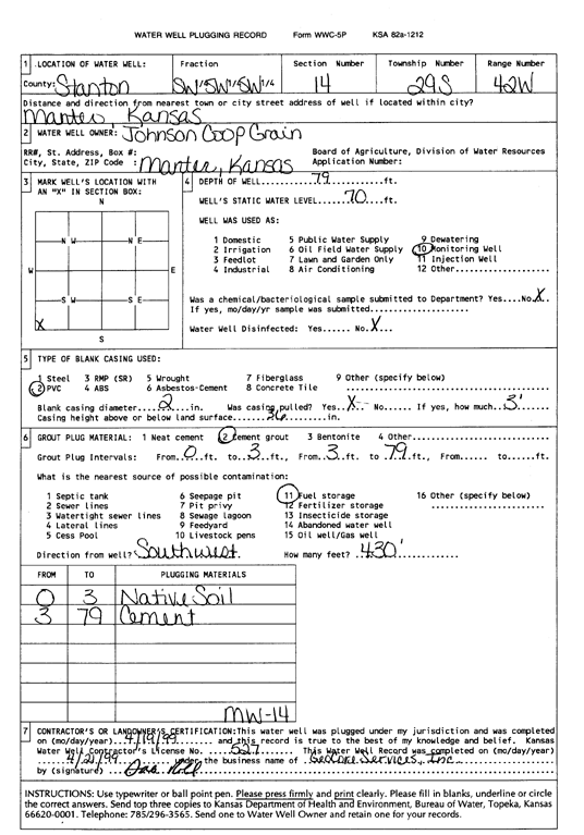
Johnson Coop Grain | 88 ft. | 74 ft. | Monitoring well/observation/piezometer | MW 15 | Plugged | 19-Apr-1999 | Scan | |
|
T29S, R42W, Sec. 14 NW SW SW |
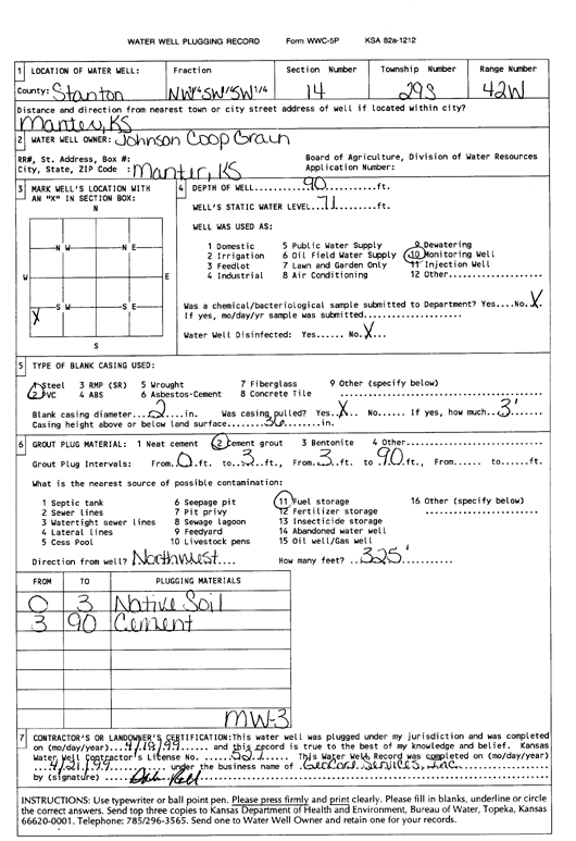
Johnson Coop Grain | 90 ft. | 71 ft. | Monitoring well/observation/piezometer | MW 3 | Plugged | 19-Apr-1999 | Scan | |
|
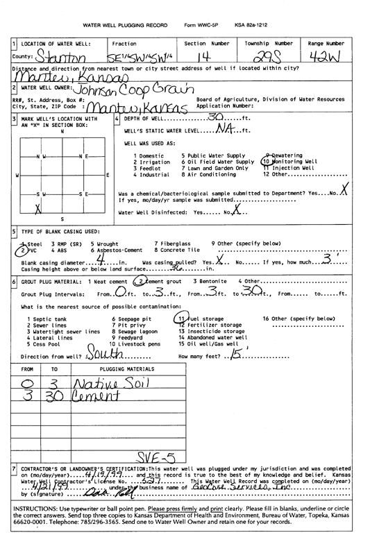
T29S, R42W, Sec. 14 SE SW SW |
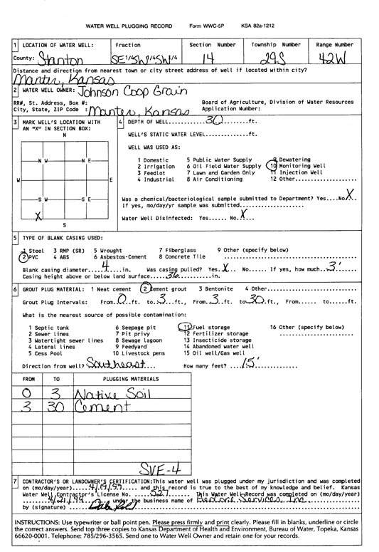
Johnson Coop Grain | 30 ft. | Monitoring well/observation/piezometer | SVE 4 | Plugged | 19-Apr-1999 | Scan | ||
|
T29S, R42W, Sec. 14 SW SW SW |
Johnson Coop Grain | 85 ft. | Monitoring well/observation/piezometer | MW 20 | Constructed | 24-Nov-1997 | |||
|
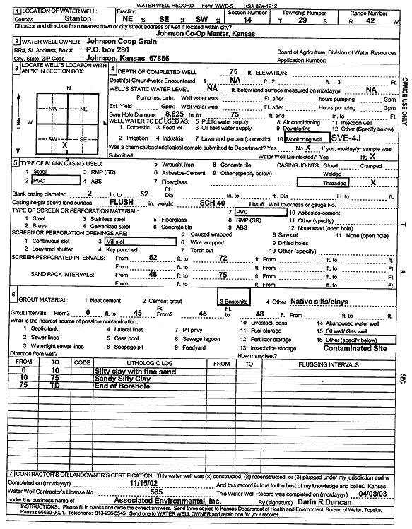
T29S, R42W, Sec. 14 NE SE SW |
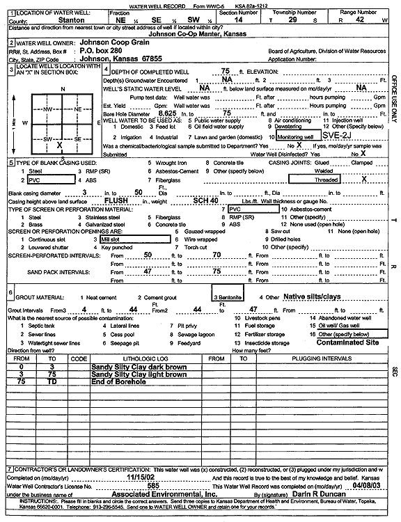
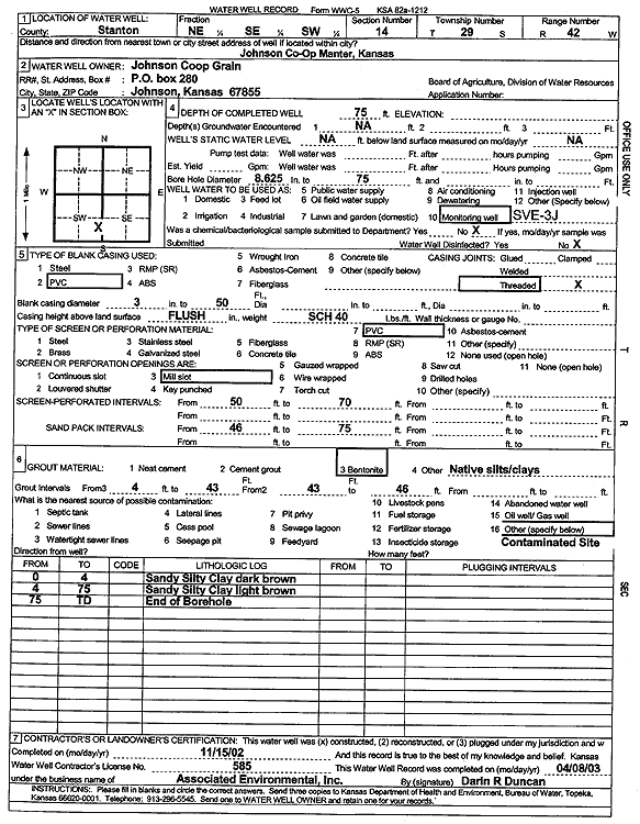
Johnson Coop Grain | 75 ft. | Environmental Remediation, Soil Vapor Extraction | SVE 2J | Constructed | 15-Nov-2002 | Scan | ||
|
T29S, R42W, Sec. 14 SE SW SW |
Johnson Coop Grain | 90 ft. | 71.09 ft. | Monitoring well/observation/piezometer | MW 9 | Constructed | 04-Dec-1996 | ||
|
T29S, R42W, Sec. 14 NE SW SW |
Johnson Coop Grain | 89 ft. | 74.56 ft. | Monitoring well/observation/piezometer | MW 15 | Constructed | 06-Dec-1996 | ||
|
T29S, R42W, Sec. 14 NE SW SW |
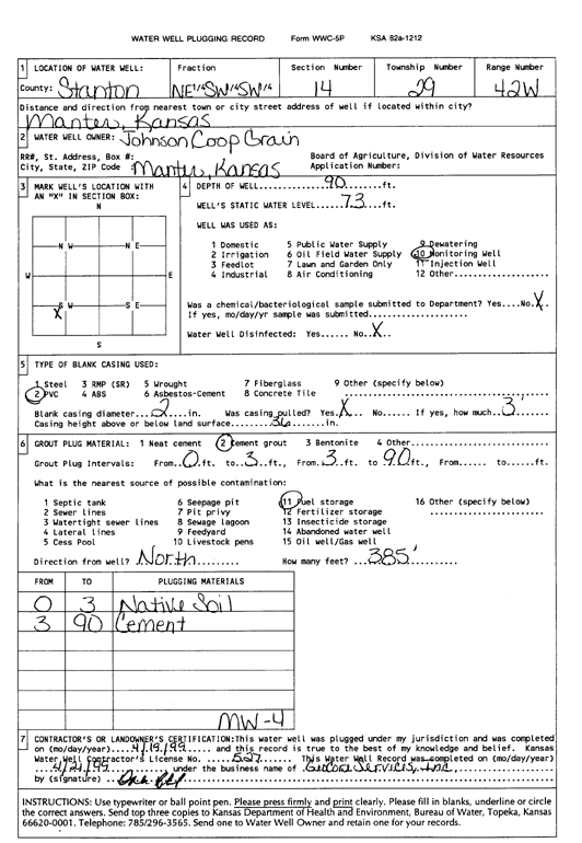
Johnson Coop Grain | 90 ft. | 73 ft. | Monitoring well/observation/piezometer | MW 4 | Plugged | 19-Apr-1999 | Scan | |
|
T29S, R42W, Sec. 14 NW SE SW |
Johnson Coop Grain | 86 ft. | 75 ft. | Monitoring well/observation/piezometer | MW 16 | Plugged | 19-Apr-1999 | Scan | |
|
T29S, R42W, Sec. 14 NW SW SW |
Johnson Coop Grain | 90 ft. | 72 ft. | Monitoring well/observation/piezometer | MW 2 | Plugged | 19-Apr-1999 | Scan | |
|
T29S, R42W, Sec. 14 SE SW SW |
Johnson Coop Grain | 30 ft. | Monitoring well/observation/piezometer | SVE 5 | Plugged | 19-Apr-1999 | Scan | ||
|
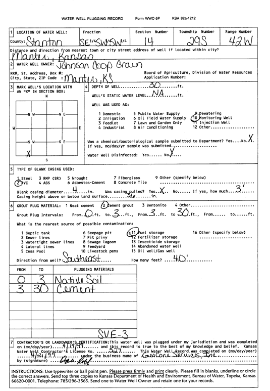
T29S, R42W, Sec. 14 SE SW SW |
Johnson Coop Grain | 30 ft. | Monitoring well/observation/piezometer | SVE 3 | Plugged | 19-Apr-1999 | Scan | ||
|
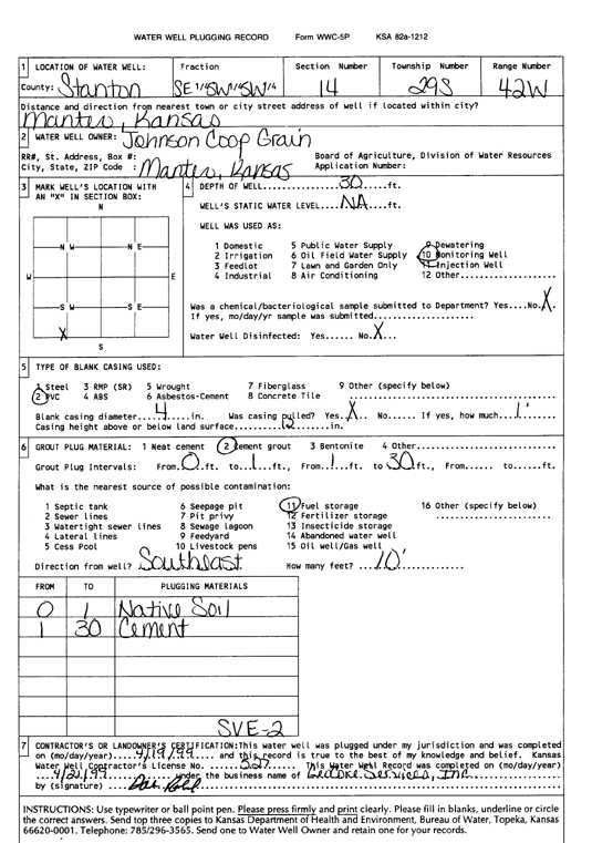
T29S, R42W, Sec. 14 SE SW SW |
Johnson Coop Grain | 30 ft. | Monitoring well/observation/piezometer | SVE 2 | Plugged | 19-Apr-1999 | Scan | ||
|
T29S, R42W, Sec. 14 SE SW SW |
Johnson Coop Grain | 79 ft. | 70 ft. | Monitoring well/observation/piezometer | MW 14 | Plugged | 19-Apr-1999 | Scan | |
|
T29S, R42W, Sec. 14 SE SW SW |
Johnson Coop Grain | 85 ft. | Monitoring well/observation/piezometer | MW 23 | Constructed | 18-Nov-1997 | |||
|
T29S, R42W, Sec. 14 SE SW SW |
Johnson Coop Grain | 30 ft. | Monitoring well/observation/piezometer | SVE 2 | Constructed | 22-Nov-1997 | |||
|
T29S, R42W, Sec. 14 SE SW SW |
Johnson Coop Grain | 85 ft. | Monitoring well/observation/piezometer | MW 19 | Constructed | 23-Nov-1997 | |||
|
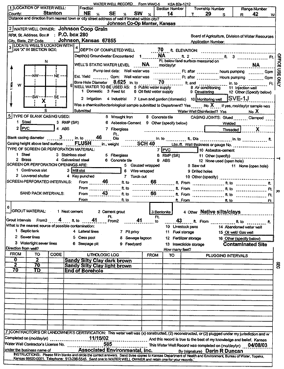
T29S, R42W, Sec. 14 NE SE SW |
Johnson Coop Grain | 75 ft. | Environmental Remediation, Soil Vapor Extraction | SVE 4J | Constructed | 15-Nov-2002 | Scan | ||
|
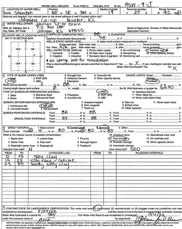
T29S, R42W, Sec. 14 NE SE SW |
Johnson Coop Grain | 88 ft. | 78 ft. | Environmental Remediation, Air Sparge | ASW 4J | Constructed | 07-Nov-2002 | Scan | |
|
T29S, R42W, Sec. 14 SE SW SW |
Johnson Coop Grain | 73 ft. | Monitoring well/observation/piezometer | MW 21 | Plugged | 09-Mar-2016 | |||
|
T29S, R42W, Sec. 14 SW SW SW |
Johnson Coop Grain | 90 ft. | 69.67 ft. | Monitoring well/observation/piezometer | MW 13 | Constructed | 05-Dec-1996 | ||
|
T29S, R42W, Sec. 14 SE SW SW |
Johnson Coop Grain | 89 ft. | 73.87 ft. | Monitoring well/observation/piezometer | MW 12 | Constructed | 05-Dec-1996 | ||
|
T29S, R42W, Sec. 14 SW SW SW |
Johnson Coop Grain | 89 ft. | 70.61 ft. | Monitoring well/observation/piezometer | MW 11 | Constructed | 05-Dec-1996 | ||
|
T29S, R42W, Sec. 14 SW SW SW |
Johnson Coop Grain | 80 ft. | 69.04 ft. | Monitoring well/observation/piezometer | MW 14 | Constructed | 06-Dec-1996 | ||
|
T29S, R42W, Sec. 14 SE SW SW |
Johnson Coop Grain | 85 ft. | Monitoring well/observation/piezometer | MW 26 | Constructed | 14-Jul-1998 | |||
|
T29S, R42W, Sec. 14 SE SW SW |
Johnson Coop Grain | 85 ft. | Monitoring well/observation/piezometer | MW 24 | Constructed | 11-Nov-1997 | |||
|
T29S, R42W, Sec. 14 SE SW SW |
Johnson Coop Grain | 90 ft. | 73.61 ft. | Monitoring well/observation/piezometer | MW 8 | Constructed | 03-Dec-1996 | ||
|
T29S, R42W, Sec. 14 SE SW SW |
Johnson Coop Grain | 90 ft. | 72.15 ft. | Monitoring well/observation/piezometer | MW 7 | Constructed | 03-Dec-1996 | ||
|
T29S, R42W, Sec. 14 SW SW SW |
Johnson Coop Grain | 70 ft. | Monitoring well/observation/piezometer | SVE 6 | Constructed | 03-Dec-1997 | |||
|
T29S, R42W, Sec. 14 SE SW SW |
Johnson Coop Grain | 85 ft. | Monitoring well/observation/piezometer | MW 18 | Constructed | 25-Nov-1997 | |||
|
T29S, R42W, Sec. 14 SE SW SW |
Johnson Coop Grain | 30 ft. | Monitoring well/observation/piezometer | SVE 5 | Constructed | 22-Nov-1997 | |||
|
T29S, R42W, Sec. 14 SE SW SW |
Johnson Coop Grain | 85 ft. | Monitoring well/observation/piezometer | MW 22 | Constructed | 20-Nov-1997 | |||
|
T29S, R42W, Sec. 14 SW SW SW |
Johnson Coop Grain | 89 ft. | 70.24 ft. | Monitoring well/observation/piezometer | MW 10 | Constructed | 04-Dec-1996 | ||
|
T29S, R42W, Sec. 14 SE SW SW |
Johnson Coop Grain | 85 ft. | Monitoring well/observation/piezometer | ASW | Constructed | 18-Nov-1997 | |||
|
T29S, R42W, Sec. 14 SE SW SW |
Johnson Coop Grain | 50 ft. | Monitoring well/observation/piezometer | SVE 9 | Constructed | 16-Jul-1998 | |||
|
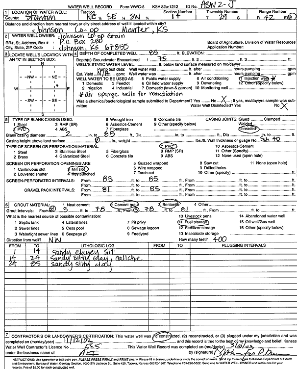
T29S, R42W, Sec. 14 NE SE SW |
Johnson Coop Grain | 85 ft. | 75 ft. | Environmental Remediation, Air Sparge | ASW 3J | Constructed | 11-Nov-2002 | Scan | |
|
T29S, R42W, Sec. 14 NE SE SW |
Johnson Coop Grain | 85 ft. | 75 ft. | Environmental Remediation, Air Sparge | ASW 2J | Constructed | 12-Nov-2002 | Scan | |
|
T29S, R42W, Sec. 14 SE SW SW |
Johnson Coop Grain | 85 ft. | Monitoring well/observation/piezometer | MW 27 | Constructed | 13-Jul-1998 | |||
|
T29S, R42W, Sec. 14 SE SW SW |
Johnson Coop Grain | 85 ft. | Monitoring well/observation/piezometer | MW 25 | Constructed | 15-Jul-1998 | |||
|
T29S, R42W, Sec. 14 NE SE SW |
Johnson Coop Grain | 75 ft. | Environmental Remediation, Soil Vapor Extraction | SVE 3J | Constructed | 15-Nov-2002 | Scan | ||
|
T29S, R42W, Sec. 14 SE SW SW |
Johnson Coop Grain | 65 ft. | Monitoring well/observation/piezometer | SVE 1 | Constructed | 21-Nov-1997 | |||
|
T29S, R42W, Sec. 14 SE SW SW |
Johnson Coop Grain | 30 ft. | Monitoring well/observation/piezometer | SVE 4 | Constructed | 22-Nov-1997 | |||
|
T29S, R42W, Sec. 14 SW SW SW |
Johnson Coop Grain | 70 ft. | Monitoring well/observation/piezometer | SVE 7 | Constructed | 04-Dec-1997 | |||
|
T29S, R42W, Sec. 14 NE SE SW |
Johnson Coop Grain | 70 ft. | Environmental Remediation, Soil Vapor Extraction | SVE 1J | Constructed | 15-Nov-2002 | Scan | ||
|
T29S, R42W, Sec. 14 SE NE SW SW |
Skyland Grain, LLC | 91 ft. | 76.04 ft. | Monitoring well/observation/piezometer | MW 32 | Constructed | 14-Sep-2009 | ||
|
T29S, R42W, Sec. 14 SE NE SW SW |
Skyland Grain, LLC | 93 ft. | 76.79 ft. | Monitoring well/observation/piezometer | MW 30 | Constructed | 14-Sep-2009 | ||
|
T29S, R42W, Sec. 14 SE NW SW |
Skyland Grain, LLC | 90 ft. | Monitoring well/observation/piezometer | ASW 5 | Constructed | 03-Sep-2010 | |||
| View page: < Prev || 11 || 12 || 13 || 14 || 15 || 16 || 17 || 18 || 19 || 20 || Next > | |||||||||