Select location of well to view details.
Click on column heading to sort.
|
|
|
County: Stanton Select location of well to view details. Click on column heading to sort. |
|
|
|
| View page: 1 || 2 || 3 || 4 || 5 || 6 || 7 || 8 || 9 || 10 || Next > | |||||||||
| T-R-S | Owner | Well Depth Ascend. Desc. |
Static Water Level Ascend. Desc. |
Est. Yield Ascend. Desc. |
Well Use | Other ID | Action Taken | Completion Date Ascend. Desc. |
Scan? |
|
T28S, R39W, Sec. 31 NE |
Haas, Kysa | 350 ft. | 284 ft. | Irrigation | Plugged | 12-Mar-2013 | |||
|
T28S, R39W, Sec. 31 SW |
Howry, Eva | 355 ft. | 320 ft. | Irrigation | Plugged | 12-Mar-2013 | |||
|
T28S, R39W, Sec. 31 NW SW SW |
Howry, Eva | 430 ft. | 241 ft. | Irrigation | Constructed | 13-Feb-1992 | |||
|
T28S, R39W, Sec. 31 C NW NE |
Julian, Basil | 449 ft. | 280 ft. | Irrigation | Constructed | 06-Jul-1990 | |||
|
T28S, R39W, Sec. 31 NE |
Knight, Heidi | 350 ft. | 284 ft. | Irrigation | Plugged | 12-Mar-2013 | |||
|
T28S, R39W, Sec. 31 NE |
Knight, Heidi | 195 ft. | 162 ft. | Irrigation | Plugged | 12-Mar-2013 | |||
|
T28S, R39W, Sec. 32 SW SW NW |
Easton, Gene | 563 ft. | 158 ft. | 1280 gpm. | Irrigation | Constructed | 18-Dec-1980 | ||
|
T28S, R39W, Sec. 32 NW |
Haas, Kysa | 355 ft. | 275 ft. | Irrigation | Plugged | 12-Mar-2013 | |||
|
T28S, R39W, Sec. 32 NW |
Knight, Heidi | 355 ft. | 275 ft. | Irrigation | Plugged | 12-Mar-2013 | |||
|
T28S, R39W, Sec. 33 NE NE SW |
Floyd, Gary | 425 ft. | 237 ft. | 30 gpm. | Domestic | Constructed | 11-Jul-1996 | ||
|
T28S, R39W, Sec. 33 SE NE NE NE |
M and G Farms | 254 ft. | 242 ft. | Domestic | Plugged | 26-Jun-2014 |
KOLAR |
||
|
T28S, R39W, Sec. 33 NW NW SW |
R and E Family Farms | 621 ft. | 249 ft. | Irrigation | Constructed | 20-Jun-2003 | Scan | ||
|
T28S, R39W, Sec. 33 NW NW SE |
R and E Family Farms | 611 ft. | 260 ft. | Irrigation | Constructed | 27-Apr-2007 | |||
|
T28S, R39W, Sec. 33 SE SW SE |
R and E Family Farms | 594 ft. | 330 ft. | Irrigation | Constructed | 30-Jun-2005 | |||
|
T28S, R39W, Sec. 33 SE NE NE NE |
R&E Family Farms | 660 ft. | 220 ft. | 18 gpm. | Domestic | Constructed | 25-Jun-2014 |
KOLAR |
|
|
T28S, R39W, Sec. 33 SW SW SW |
Winger, Melvin | 606.1 ft. | 204 ft. | 3000 gpm. | Irrigation | Constructed | 15-Jul-1975 | ||
|
T28S, R39W, Sec. 34 SE SE SE |
Broyles, Jake | 310 ft. | 143 ft. | 30 gpm. | Domestic | Constructed | 28-Jun-1977 | ||
|
T28S, R39W, Sec. 35 SE NW SW |
Eyman, Lula | 433 ft. | 205 ft. | 25 gpm. | Domestic | Constructed | 21-Jul-1986 | ||
|
T28S, R39W, Sec. 35 SE SW SW |
Johnson Coop Grain | 125 ft. | 122.8 ft. | Monitoring well/observation/piezometer | MW 3 | Plugged | 22-Feb-2001 | Scan | |
|
T28S, R39W, Sec. 35 SE SW SW |
Johnson Coop Grain | 138 ft. | 108.1 ft. | Monitoring well/observation/piezometer | MW 4 | Constructed | 17-Jan-1994 | ||
|
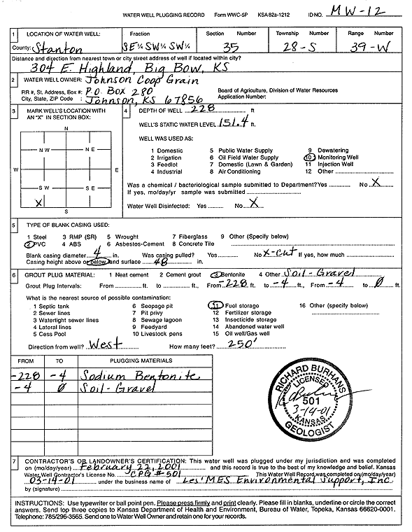
T28S, R39W, Sec. 35 SE SW SW |
Johnson Coop Grain | 228.2 ft. | 147.6 ft. | Monitoring well/observation/piezometer | MW 12 | Constructed | 13-Jan-1994 | ||
|
T28S, R39W, Sec. 35 SE SW SW |
Johnson Coop Grain | 119.7 ft. | 111.2 ft. | Monitoring well/observation/piezometer | MW 1 | Constructed | 20-Jan-1994 | ||
|
T28S, R39W, Sec. 35 SE SE SW |
Johnson Coop Grain | 120 ft. | 111 ft. | Monitoring well/observation/piezometer | Constructed | 24-Jan-1991 | |||
|
T28S, R39W, Sec. 35 SE SW SW |
Johnson Coop Grain | 122.8 ft. | 114.9 ft. | Monitoring well/observation/piezometer | MW 2 | Constructed | 20-Oct-1994 | ||
|
T28S, R39W, Sec. 35 SE SW SW |
Johnson Coop Grain | 228 ft. | 151.4 ft. | Monitoring well/observation/piezometer | MW 12 | Plugged | 22-Feb-2001 | Scan | |
|
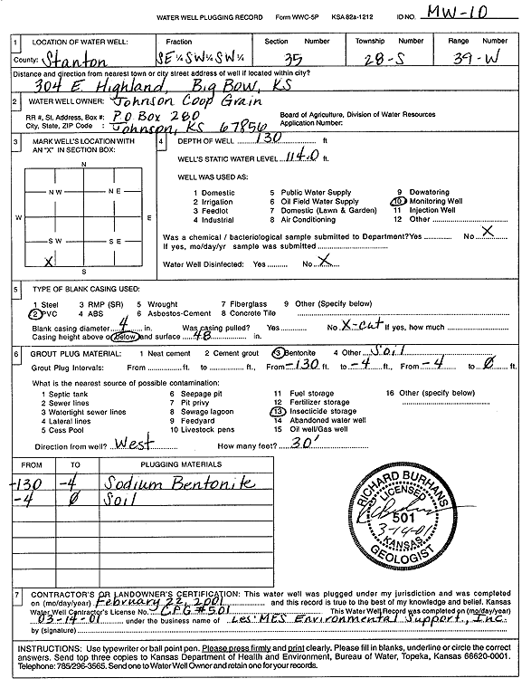
T28S, R39W, Sec. 35 SE SW SW |
Johnson Coop Grain | 130 ft. | 111.2 ft. | Monitoring well/observation/piezometer | SB 10 | Constructed | 14-Jan-1994 | ||
|
T28S, R39W, Sec. 35 SE SW SW |
Johnson Coop Grain | 125 ft. | 119.3 ft. | Monitoring well/observation/piezometer | MW 3 | Constructed | 20-Jan-1994 | ||
|
T28S, R39W, Sec. 35 SE SW SW |
Johnson Coop Grain | 228 ft. | 178.7 ft. | Monitoring well/observation/piezometer | SB 6 | Constructed | 17-Jan-1994 | ||
|
T28S, R39W, Sec. 35 SE SW SW |
Johnson Coop Grain | 130 ft. | 114 ft. | Monitoring well/observation/piezometer | MW 10 | Plugged | 22-Feb-2001 | Scan | |
|
T28S, R39W, Sec. 35 SW SW SW |
Johnson Coop Grain | 133.5 ft. | 120.91 ft. | Monitoring well/observation/piezometer | MW 3 R | Constructed | 10-Aug-2010 | ||
|
T28S, R39W, Sec. 35 SW SE SW SW |
Johnson Coop Grain Inc | 218.31 ft. | 199.96 ft. | Monitoring well/observation/piezometer | MW 6 | Plugged | 26-Jul-2011 | ||
|
T28S, R39W, Sec. 35 SW SE SW SW |
Johnson Coop Grain Inc | 128.7 ft. | 120.11 ft. | Monitoring well/observation/piezometer | MWC 3 | Plugged | 26-Jul-2011 | ||
|
T28S, R39W, Sec. 35 SW SE SW SW |
Johnson Coop Grain Inc | 130.86 ft. | 125.15 ft. | Monitoring well/observation/piezometer | MW 3 R | Plugged | 26-Jul-2011 | ||
|
T28S, R39W, Sec. 35 SW SE SW SW |
Johnson Coop Grain Inc | 119.65 ft. | 114.65 ft. | Monitoring well/observation/piezometer | MW 1 | Plugged | 26-Jul-2011 | ||
|
T28S, R39W, Sec. 35 SW SE SW SW |
Johnson Coop Grain Inc | 122.89 ft. | 122.35 ft. | Monitoring well/observation/piezometer | MW 2 | Plugged | 26-Jul-2011 | ||
|
T28S, R39W, Sec. 35 NE SW SW |
Pearce, Frank Ralph | 302 ft. | 150 ft. | Domestic | Constructed | 18-Jan-1975 | |||
|
T28S, R39W, Sec. 35 SE SW SW |
Skyland Grain | 115 ft. | Monitoring well/observation/piezometer | MWC 1 | Plugged | 10-Sep-2007 | |||
|
T28S, R39W, Sec. 35 SE SW SW |
Skyland Grain | 133 ft. | Monitoring well/observation/piezometer | Constructed | 11-Sep-2007 | ||||
|
T28S, R39W, Sec. 35 SE SW SW |
Skyland Grain | 97 ft. | Monitoring well/observation/piezometer | MWC 2 | Plugged | 10-Sep-2007 | |||
|
T28S, R39W, Sec. 35 SW SW SW |
USD 452 | 320 ft. | 170 ft. | Domestic | Constructed | 13-Aug-1980 | |||
|
T28S, R39W, Sec. 35 SW SW SW |
Whitcomb, Morris | 296 ft. | 143 ft. | 30 gpm. | Domestic | Constructed | 28-Sep-1978 | ||
|
T28S, R39W, Sec. 35 NW NW NE NW |
Wilson, Leonard | 240 ft. | Domestic, Lawn and Garden | Plugged | 31-Jan-2014 | ||||
|
T28S, R39W, Sec. 35 NW NW NE NW |
Wilson, Leonard | 456 ft. | 238 ft. | 25 gpm. | Domestic, Lawn and Garden | Constructed | 08-Oct-2013 |
KOLAR |
|
|
T28S, R39W, Sec. 36 NW NW NE |
Shore, Lee | 567.6 ft. | 187 ft. | Irrigation | Constructed | 16-Apr-1985 | |||
|
T28S, R39W, Sec. 36 SW SE NW |
Shore, Lee | 575 ft. | 171.6 ft. | 1500 gpm. | Irrigation | Constructed | 30-Apr-1976 | ||
|
T28S, R39W, Sec. 36 NW NW NE |
Shore, Lee | 566 ft. | 187 ft. | 1106 gpm. | Irrigation | Constructed | 06-May-1983 | ||
|
T28S, R40W, Sec. 1 SE NE SE |
Nichols, Ivan | 360 ft. | 168 ft. | 35 gpm. | Domestic, Livestock | Constructed | 10-Jun-1982 | ||
|
T28S, R40W, Sec. 2 SE SE SW |
H and C Farms Inc. | 620 ft. | 260 ft. | Irrigation | Constructed | 15-May-2008 | |||
|
T28S, R40W, Sec. 2 SE SE SW |
H and C Farms Inc. | 616 ft. | 222 ft. | 1300 gpm. | Irrigation | Constructed | 05-May-1994 | ||
|
T28S, R40W, Sec. 2 NW NW NW |
Winger, Melvin | 622 ft. | 212 ft. | 1150 gpm. | Irrigation | Constructed | 07-May-1998 | ||
| View page: 1 || 2 || 3 || 4 || 5 || 6 || 7 || 8 || 9 || 10 || Next > | |||||||||