Select location of well to view details.
Click on column heading to sort.
|
|
|
County: Stevens Select location of well to view details. Click on column heading to sort. |
|
|
|
| View page: < Prev || 21 || 22 || 23 || 24 || 25 || 26 || 27 || 28 || 29 || 30 || Next > | |||||||||
| T-R-S | Owner | Well Depth Ascend. Desc. |
Static Water Level Ascend. Desc. |
Est. Yield Ascend. Desc. |
Well Use | Other ID | Action Taken | Completion Date Ascend. Desc. |
Scan? |
|
T33S, R36W, Sec. 24 NE NE NW |
Heger, Robb | 440 ft. | 230 ft. | 25 gpm. | Domestic | Constructed | 20-Oct-1997 | ||
|
T33S, R36W, Sec. 24 SE SW SE SW |
J and T Heirs | 615 ft. | 288 ft. | 1475 gpm. | Irrigation | Constructed | 25-Sep-2014 |
KOLAR |
|
|
T33S, R36W, Sec. 24 NW NE SE |
Walkemeyer, Roy | 628 ft. | 134 ft. | Irrigation | Constructed | 31-May-1976 | |||
|
T33S, R36W, Sec. 25 SE SE SE SW |
Heger, Marlin | 506 ft. | 287 ft. | 903 gpm. | Irrigation | Constructed | 21-Jun-2013 |
KOLAR |
|
|
T33S, R36W, Sec. 25 NE NE SW |
Heger, Marlin and Erma | 542 ft. | 329 ft. | 1000 gpm. | Irrigation | Constructed | 29-Jul-2025 |
KOLAR |
|
|
T33S, R36W, Sec. 26 NE NE NE SW |
Heger, Marlin | 385 ft. | 290 ft. | Irrigation | Plugged | 07-Jan-2020 | |||
|
T33S, R36W, Sec. 26 NW NE SE |
Heger, Marlin | 340 ft. | 275 ft. | Irrigation | Plugged | 16-Dec-2011 | |||
|
T33S, R36W, Sec. 26 SW SE NE SE |
Heger, Marlin and Erma | 401 ft. | 283 ft. | 1003 gpm. | Irrigation | Constructed | 24-Mar-2015 |
KOLAR |
|
|
T33S, R36W, Sec. 26 SE SE SE |
Heger, Rudolph | 360 ft. | 210 ft. | 100 gpm. | Domestic | Constructed | 25-Sep-1975 | ||
|
T33S, R36W, Sec. 26 NE NE SW |
Peoples National Bank | 334 ft. | 181 ft. | Irrigation | Constructed | 20-May-1981 | |||
|
T33S, R36W, Sec. 27 NE |
Concannon, Don | 360 ft. | 138 ft. | 1300 gpm. | Irrigation | Constructed | 12-Aug-1980 | ||
|
T33S, R36W, Sec. 27 C NE NE |
Douglas Energies/Robert Davis | 260 ft. | 109 ft. | 60 gpm. | Oil Field Water Supply | Davis 1-27 | Plugged | 13-Oct-1982 | |
|
T33S, R36W, Sec. 27 C NE NE |
Douglas Energies/Robert Davis | 260 ft. | 109 ft. | 60 gpm. | Oil Field Water Supply | Davis 1-27 | Constructed | 22-Apr-1982 | |
|
T33S, R36W, Sec. 30 NE SW SW |
Stegman, A J | 410 ft. | Domestic | Constructed | 08-Jun-2010 | ||||
|
T33S, R36W, Sec. 31 SE NE SE NE |
Bultman, Alan | 465 ft. | 174 ft. | 20 gpm. | Domestic, Lawn and Garden | Constructed | 13-Aug-2016 |
KOLAR |
|
|
T33S, R36W, Sec. 31 NW NE NW |
Heger, Marlin | 592 ft. | 108 ft. | 675 gpm. | Irrigation | Constructed | 05-Jan-1996 | ||
|
T33S, R36W, Sec. 32 SE NE NE |
Cox, Jeff | 572 ft. | 175 ft. | Irrigation | Constructed | 21-Dec-2000 | Scan | ||
|
T33S, R36W, Sec. 33 SW SE SW |
Walkemeyer, Roy | 643 ft. | 182 ft. | Irrigation | Constructed | 20-May-1996 | |||
|
T33S, R36W, Sec. 34 NE NE NE |
Terrol Energy Inc. | 320 ft. | 170 ft. | 70 gpm. | Oil Field Water Supply | Morford 1-34 | Constructed | 11-Jun-1990 | |
|
T33S, R36W, Sec. 34 NE NE SE |
Walkemeyer, Roy | 404 ft. | 167 ft. | 100 gpm. | Domestic | Constructed | 20-Nov-1981 | ||
|
T33S, R36W, Sec. 34 NW NW SE |
Walkemeyer, Roy | 540 ft. | 145 ft. | Irrigation | Constructed | 08-Feb-1977 | |||
|
T33S, R36W, Sec. 35 SW SE NW |
Roy Walkemeyer Trust | 462 ft. | 243 ft. | Irrigation | Constructed | 16-Oct-2001 | Scan | ||
|
T33S, R36W, Sec. 35 SW SE SW SW |
Walkemeyer, Roy | 640 ft. | 302 ft. | 1003 gpm. | Irrigation | Constructed | 23-Apr-2021 |
KOLAR |
|
|
T33S, R36W, Sec. 35 NE SW SE |
Wheeler and Sons | 543 ft. | 265 ft. | Irrigation | Constructed | 22-Aug-1978 | |||
|
T33S, R36W, Sec. 36 NW NW NW |
Anadarko Petroleum Corp. | 420 ft. | 227 ft. | 100 gpm. | Oil Field Water Supply | Heger D-1 | Constructed | 08-Jan-1998 | |
|
T33S, R36W, Sec. 36 SE SE NW |
Heger, Marlin and Gary | 505 ft. | 149 ft. | 1500 gpm. | Irrigation | Constructed | 20-Feb-1979 | ||
|
T33S, R37W, Sec. 1 NW SW SW SW |
A-Z Livestock | 505 ft. | 260 ft. | Test hole/well | Plugged | 05-Sep-2017 |
KOLAR |
||
|
T33S, R37W, Sec. 1 NW SW SW SW |
A-Z Livestock | 420 ft. | 182 ft. | 13 gpm. | Domestic, Livestock | Constructed | 19-Sep-2016 |
KOLAR |
|
|
T33S, R37W, Sec. 1 SW SW NW |
Demuth, Tex | 273 ft. | 120 ft. | 30 gpm. | Domestic | Constructed | 30-Apr-1990 | ||
|
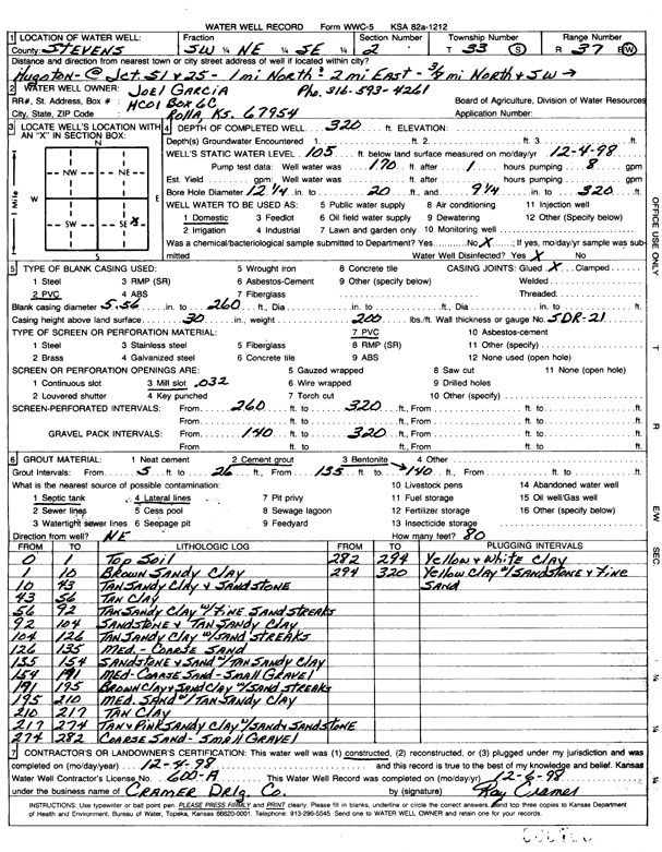
T33S, R37W, Sec. 2 SW NE SE |
Garcia, Joel | 320 ft. | 105 ft. | Domestic | Constructed | 04-Dec-1998 | Scan | ||
|
T33S, R37W, Sec. 2 SE SE NE |
Willis, Mike | 435 ft. | 265 ft. | 25 gpm. | Domestic, Livestock | Constructed | 29-Oct-2024 |
KOLAR |
|
|
T33S, R37W, Sec. 2 NW SE SW |
Wing, Matt | 250 ft. | 170 ft. | 15 gpm. | Domestic | Constructed | 26-Oct-1989 | ||
|
T33S, R37W, Sec. 3 SW SW NE |
Bach, Benjamin | 340 ft. | 122 ft. | Domestic | Constructed | 06-Mar-2026 |
KOLAR |
||
|
T33S, R37W, Sec. 3 NE NW SW |
Northern Natural Gas Co. | 30 ft. | Environmental Remediation, Soil Vapor Extraction | SB1/SV1 | Constructed | 13-May-2004 | |||
|
T33S, R37W, Sec. 3 NE NW SW |
Northern Natural Gas Co. | 30 ft. | Environmental Remediation, Soil Vapor Extraction | SB2/SV2 | Constructed | 13-May-2004 | |||
|
T33S, R37W, Sec. 3 NW NW NW |
Northern Natural Gas Co. | 200 ft. | 103 ft. | 23 gpm. | Industrial | Constructed | 07-Aug-1979 | ||
|
T33S, R37W, Sec. 3 NE NW SW |
Northern Natural Gas Co. | 30 ft. | Environmental Remediation, Soil Vapor Extraction | SB4/SV4 | Constructed | 14-May-2004 | |||
|
T33S, R37W, Sec. 3 NE NW SW |
Northern Natural Gas Co. | 30 ft. | Environmental Remediation, Soil Vapor Extraction | SB3/SV3 | Constructed | 13-May-2004 | |||
|
T33S, R37W, Sec. 3 NE NW SW |
Northern Natural Gas Co. | 15 ft. | Environmental Remediation, Soil Vapor Extraction | SVE 1 | Constructed | 02-Nov-1995 | |||
|
T33S, R37W, Sec. 4 NW NE NW NE |
Cruz, Gonzalo | 302 ft. | 134 ft. | 50 gpm. | Domestic | Constructed | 05-Mar-2020 | ||
|
T33S, R37W, Sec. 4 NE SE NE |
Swartz, Gordon | 232 ft. | 103 ft. | Domestic | Constructed | 02-Nov-1995 | |||
|
T33S, R37W, Sec. 4 SE SE SW |
Wolters, Richard B. | 90 ft. | 95 ft. | Domestic | Plugged | 09-Sep-1996 | |||
|
T33S, R37W, Sec. 4 SE SE SW |
Wolters, Rick | 247 ft. | 86 ft. | 60 gpm. | Domestic | Constructed | 06-Aug-1985 | ||
|
T33S, R37W, Sec. 4 SE SE SW |
Wolters, Rick | 250 ft. | 90 ft. | 75 gpm. | (unstated)/abandoned | Plugged | 27-Jul-1987 | ||
|
T33S, R37W, Sec. 4 SE SE SW |
Wolters, Rick | 250 ft. | 90 ft. | 75 gpm. | Domestic | Constructed | 27-Jul-1987 | ||
|
T33S, R37W, Sec. 4 NE NW NE |
Wolters, Rick | 547 ft. | 126 ft. | 50 gpm. | Domestic | Constructed | 29-Jul-2014 | ||
|
T33S, R37W, Sec. 5 NW SE SE |
Hansen-Mueller | 520 ft. | Domestic | Constructed | 04-Jun-2010 | ||||
|
T33S, R37W, Sec. 5 C NW NW |
Schmidt, Jim | 340 ft. | 125 ft. | 100 gpm. | Oil Field Water Supply | Schmidt A 105 | Constructed | 25-Nov-1989 | |
|
T33S, R37W, Sec. 6 NE SW SW |
Anadarko Petroleum Corp. | 240 ft. | 100 ft. | 50 gpm. | Oil Field Water Supply | Kuharic A-1 | Constructed | 27-May-1975 | |
|
T33S, R37W, Sec. 6 NW NE SE |
Kuharic, George | 298 ft. | 107 ft. | 50 gpm. | Domestic | Constructed | 06-Nov-1979 | ||
| View page: < Prev || 21 || 22 || 23 || 24 || 25 || 26 || 27 || 28 || 29 || 30 || Next > | |||||||||