Select location of well to view details.
Click on column heading to sort.
|
|
|
County: Stevens Select location of well to view details. Click on column heading to sort. |
|
|
|
| View page: < Prev || 21 || 22 || 23 || 24 || 25 || 26 || 27 || 28 || 29 || 30 || Next > | |||||||||
| T-R-S | Owner | Well Depth Ascend. Desc. |
Static Water Level Ascend. Desc. |
Est. Yield Ascend. Desc. |
Well Use | Other ID | Action Taken | Completion Date Ascend. Desc. |
Scan? |
|
T33S, R37W, Sec. 16 SW SW NE |
City of Hugoton | 101 ft. | Environmental Remediation, Air Sparge | AS 20 | Plugged | 07-Mar-2006 | |||
|
T33S, R37W, Sec. 16 SW SW NE |
City of Hugoton | 43 ft. | Environmental Remediation, Soil Vapor Extraction | SV 5 | Plugged | 08-Mar-2006 | |||
|
T33S, R37W, Sec. 16 SW SW NE |
City of Hugoton | 45 ft. | Environmental Remediation, Soil Vapor Extraction | SV C 1 | Plugged | 08-Mar-2006 | |||
|
T33S, R37W, Sec. 16 SW SW NE |
City of Hugoton | 131 ft. | Monitoring well/observation/piezometer | MW 28 | Plugged | 08-Mar-2006 | |||
|
T33S, R37W, Sec. 16 SE NW NW |
City of Hugoton | 125 ft. | Monitoring well/observation/piezometer | City 2 | Plugged | 08-Mar-2006 | |||
|
T33S, R37W, Sec. 16 SE NW NW |
City of Hugoton | 44.4 ft. | Environmental Remediation, Soil Vapor Extraction | SV 6 | Plugged | 08-Mar-2006 | |||
|
T33S, R37W, Sec. 16 SW SW NE |
City of Hugoton | 100 ft. | Environmental Remediation, Air Sparge | AS C 1 | Plugged | 08-Mar-2006 | |||
|
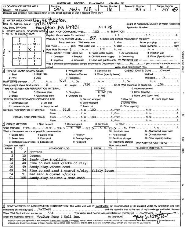
T33S, R37W, Sec. 16 C SW NE |
City of Hugoton | 140 ft. | 116 ft. | Monitoring well/observation/piezometer | Well 3 | Constructed | 25-Sep-1987 | ||
|
T33S, R37W, Sec. 16 SW SW NE |
City of Hugoton | 300 ft. | 100 ft. | Public Water Supply | Well 1 | Plugged | 12-Jul-1977 | ||
|
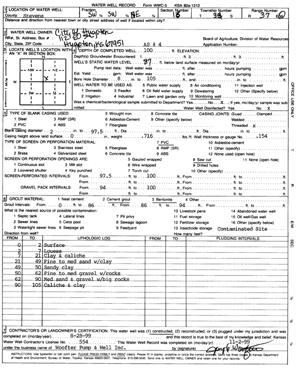
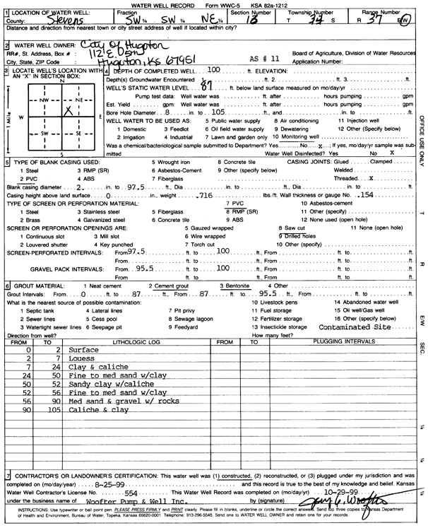
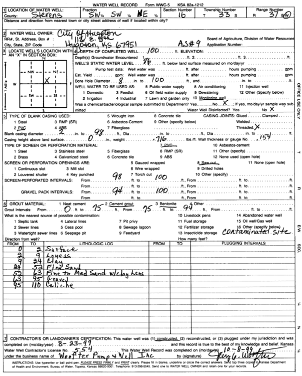
T33S, R37W, Sec. 16 SW SW NE |
City of Hugoton | 100 ft. | 87 ft. | Environmental Remediation, Air Sparge | AS 4 | Constructed | 28-Aug-1999 | Scan | |
|
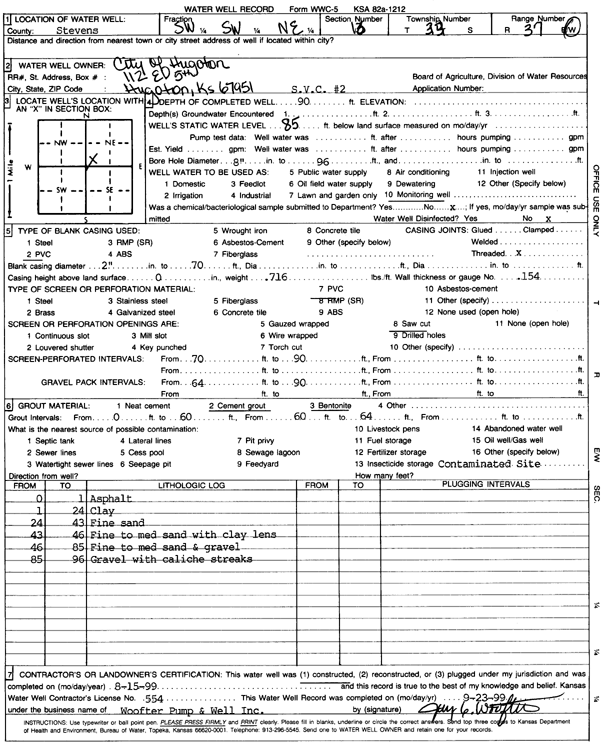
T33S, R37W, Sec. 16 SW SW NE |
City of Hugoton | 100 ft. | 87 ft. | Monitoring well/observation/piezometer | AS 14 | Constructed | 26-Aug-1999 | Scan | |
|
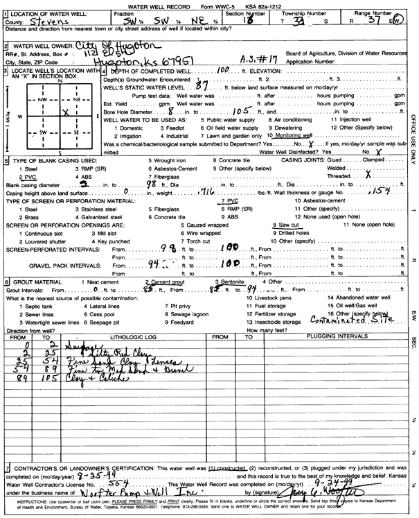
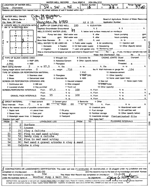
T33S, R37W, Sec. 16 SW SW NE |
City of Hugoton | 100 ft. | 87 ft. | Environmental Remediation, Air Sparge | AS 17 | Constructed | 25-Aug-1999 | Scan | |
|
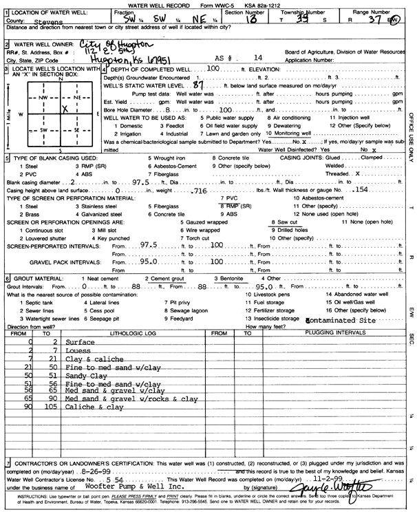
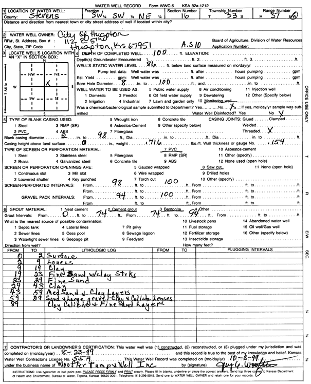
T33S, R37W, Sec. 16 SW SW NE |
City of Hugoton | 100 ft. | 86 ft. | Environmental Remediation, Air Sparge | AS 10 | Constructed | 23-Aug-1999 | Scan | |
|
T33S, R37W, Sec. 16 SW SW NE |
City of Hugoton | 100 ft. | 87 ft. | Environmental Remediation, Air Sparge | AS 11 | Constructed | 25-Aug-1999 | Scan | |
|
T33S, R37W, Sec. 16 SW SW NE |
City of Hugoton | 100 ft. | 86 ft. | Environmental Remediation, Air Sparge | AS 16 | Constructed | 27-Aug-1999 | Scan | |
|
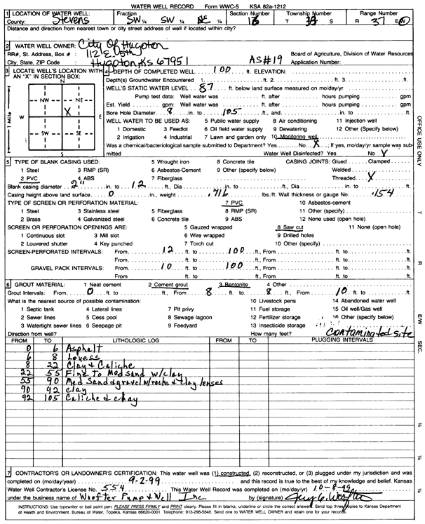
T33S, R37W, Sec. 16 SW SW NE |
City of Hugoton | 100 ft. | 87 ft. | Environmental Remediation, Air Sparge | AS 19 | Constructed | 02-Sep-1999 | Scan | |
|
T33S, R37W, Sec. 16 SW SW NE |
City of Hugoton | 100 ft. | 87 ft. | Environmental Remediation, Air Sparge | AS 20 | Constructed | 22-Sep-1999 | Scan | |
|
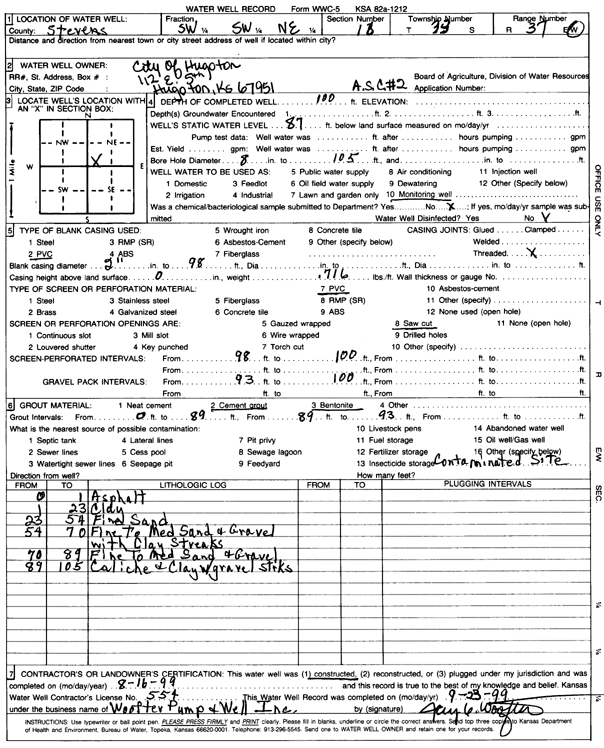
T33S, R37W, Sec. 16 SW SW NE |
City of Hugoton | 100 ft. | 87 ft. | Monitoring well/observation/piezometer | ASC 2 | Constructed | 16-Aug-1999 | Scan | |
|
T33S, R37W, Sec. 16 SW SW NE |
City of Hugoton | 100 ft. | 86 ft. | Monitoring well/observation/piezometer | Constructed | 23-Aug-1999 | Scan | ||
|
T33S, R37W, Sec. 16 SW SW NE |
City of Hugoton | 90 ft. | 85 ft. | Monitoring well/observation/piezometer | SVC 2 | Constructed | 15-Aug-1999 | Scan | |
|
T33S, R37W, Sec. 16 SW SW NE |
City of Hugoton | 100 ft. | 87 ft. | Environmental Remediation, Air Sparge | AS 15 | Constructed | 26-Aug-1999 | Scan | |
|
T33S, R37W, Sec. 16 NE NW NE |
Collingwood Grain, Inc. | 150 ft. | 123.29 ft. | Monitoring well/observation/piezometer | MW 7 | Constructed | 14-Sep-2005 | ||
|
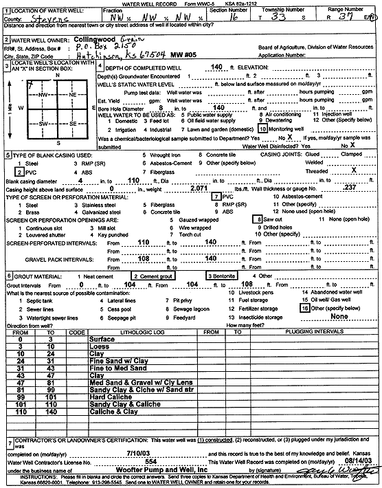
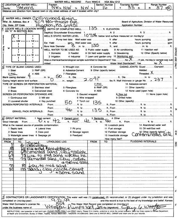
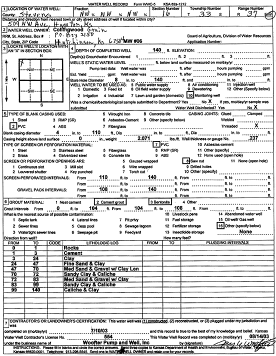
T33S, R37W, Sec. 16 NW NW NW |
Collingwood Grain, Inc. | 140 ft. | Monitoring well/observation/piezometer | MW 5 | Constructed | 10-Jul-2003 | Scan | ||
|
T33S, R37W, Sec. 16 NW NW NW |
Collingwood Grain, Inc. | 136.9 ft. | Monitoring well/observation/piezometer | MW 5 | Plugged | 23-May-2012 | |||
|
T33S, R37W, Sec. 16 NW NW NW |
Collingwood Grain, Inc. | 123.41 ft. | Monitoring well/observation/piezometer | MW 4 | Plugged | 23-May-2012 | |||
|
T33S, R37W, Sec. 16 NW NW NW |
Collingwood Grain, Inc. | 185 ft. | 151.8 ft. | Monitoring well/observation/piezometer | MW 5 R | Constructed | 09-Nov-2011 | ||
|
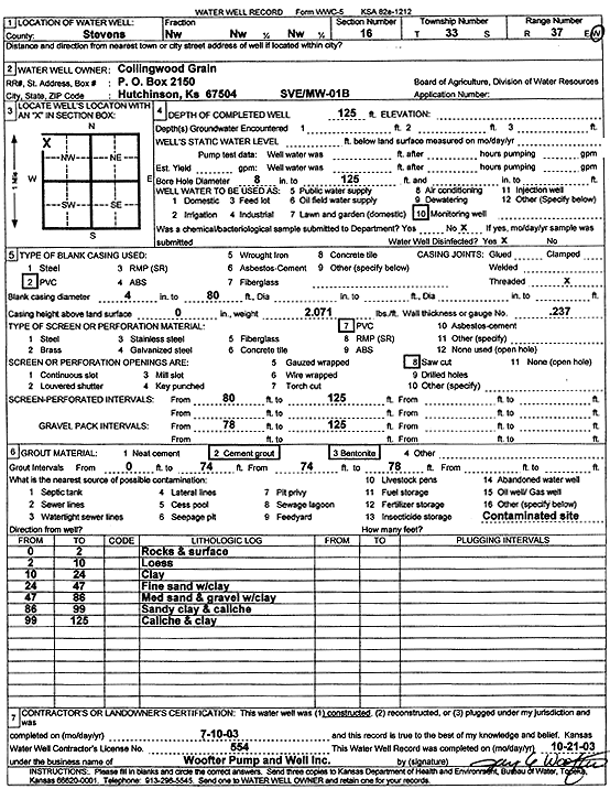
T33S, R37W, Sec. 16 NW NW NW |
Collingwood Grain, Inc. | 125 ft. | Monitoring well/observation/piezometer | MW 1B | Constructed | 10-Jul-2003 | Scan | ||
|
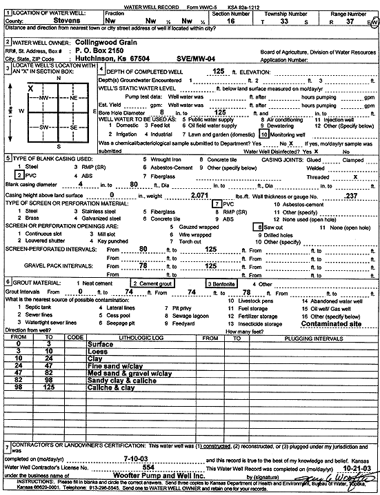
T33S, R37W, Sec. 16 NW NW NW |
Collingwood Grain, Inc. | 125 ft. | Monitoring well/observation/piezometer | MW 4 | Constructed | 10-Jul-2003 | Scan | ||
|
T33S, R37W, Sec. 16 NW NW NW |
Collingwood Grain, Inc. | 139.9 ft. | Monitoring well/observation/piezometer | MW 6 | Plugged | 23-May-2012 | |||
|
T33S, R37W, Sec. 16 NW NW NW |
Collingwood Grain, Inc. | 180 ft. | 149.3 ft. | Monitoring well/observation/piezometer | MW 6 R | Constructed | 09-Nov-2011 | ||
|
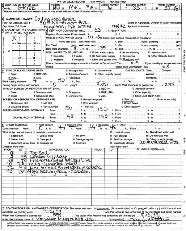
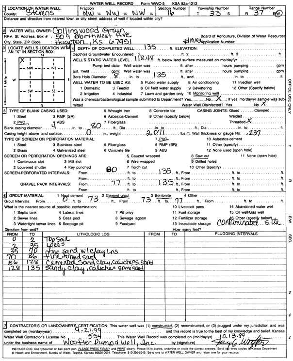
T33S, R37W, Sec. 16 NW NW NW |
Collingwood Grain, Inc. | 135 ft. | 111.2 ft. | Monitoring well/observation/piezometer | MW 2 | Constructed | 21-Sep-1999 | Scan | |
|
T33S, R37W, Sec. 16 NW NW NW |
Collingwood Grain, Inc. | 133.55 ft. | Monitoring well/observation/piezometer | MW 3 | Plugged | 23-May-2012 | |||
|
T33S, R37W, Sec. 16 NE NW NE |
Collingwood Grain, Inc. | 115.2 ft. | Monitoring well/observation/piezometer | MW 7 | Plugged | 23-May-2012 | |||
|
T33S, R37W, Sec. 16 NW NW NW |
Collingwood Grain, Inc. | 185 ft. | 150.61 ft. | Monitoring well/observation/piezometer | MW 4 R | Constructed | 09-Nov-2011 | ||
|
T33S, R37W, Sec. 16 NW NW NW |
Collingwood Grain, Inc. | 124.35 ft. | Monitoring well/observation/piezometer | MW 1 B | Plugged | 23-May-2012 | |||
|
T33S, R37W, Sec. 16 NW NW NW |
Collingwood Grain, Inc. | 135.8 ft. | Monitoring well/observation/piezometer | MW 1 A | Plugged | 23-May-2012 | |||
|
T33S, R37W, Sec. 16 NW NW NW |
Collingwood Grain, Inc. | 135 ft. | 118.5 ft. | Monitoring well/observation/piezometer | MW 3 | Constructed | 21-Sep-1999 | Scan | |
|
T33S, R37W, Sec. 16 NW NW NW |
Collingwood Grain, Inc. | 135 ft. | 107 ft. | Monitoring well/observation/piezometer | Constructed | 21-Sep-1999 | Scan | ||
|
T33S, R37W, Sec. 16 NW NW NW |
Collingwood Grain, Inc. | 140 ft. | Monitoring well/observation/piezometer | MW 6 | Constructed | 10-Jul-2003 | Scan | ||
|
T33S, R37W, Sec. 16 NE NW NW SE |
Early Childhood Development Center | 300 ft. | Heat Pump (Closed Loop/Disposal), Geothermal | Constructed | 04-Aug-2010 | ||||
|
T33S, R37W, Sec. 16 SE SE SE SE |
Frontier Fuel | 200 ft. | 117.96 ft. | Monitoring well/observation/piezometer | MW 2 | Constructed | 03-Mar-2017 | ||
|
T33S, R37W, Sec. 16 SE SE SE SE |
Frontier Fuel | 149.6 ft. | 118.03 ft. | Monitoring well/observation/piezometer | MW 3 | Plugged | 16-Aug-2018 | ||
|
T33S, R37W, Sec. 16 SE SE SE SE |
Frontier Fuel | 148.9 ft. | 118.1 ft. | Monitoring well/observation/piezometer | MW 1 | Plugged | 16-Aug-2018 | ||
|
T33S, R37W, Sec. 16 SE SE SE SE |
Frontier Fuel | 199.2 ft. | 118.87 ft. | Monitoring well/observation/piezometer | MW 2 | Plugged | 16-Aug-2018 | ||
|
T33S, R37W, Sec. 16 SE SE SE SE |
Frontier Fuel | 151.7 ft. | 118.3 ft. | Monitoring well/observation/piezometer | MW 4 | Plugged | 16-Aug-2018 | ||
|
T33S, R37W, Sec. 16 SE SE SE SE |
Frontier Fuel | 199.1 ft. | 118.81 ft. | Monitoring well/observation/piezometer | MW 5 | Plugged | 16-Aug-2018 | ||
|
T33S, R37W, Sec. 16 SE SE SE SE |
Frontier Fuel | 200 ft. | 118.04 ft. | Monitoring well/observation/piezometer | MW 5 | Constructed | 03-Mar-2017 | ||
|
T33S, R37W, Sec. 16 SE SE SE SE |
Frontier Fuel | 150 ft. | 117.3 ft. | Monitoring well/observation/piezometer | MW 3 | Constructed | 03-Mar-2017 | ||
|
T33S, R37W, Sec. 16 SE SE SE SE |
Frontier Fuel | 151.5 ft. | 117.68 ft. | Monitoring well/observation/piezometer | MW 4 | Constructed | 03-Mar-2017 | ||
|
T33S, R37W, Sec. 16 SE SE SE SE |
Frontier Fuel | 150 ft. | 117.55 ft. | Monitoring well/observation/piezometer | MW 1 | Constructed | 03-Mar-2017 | ||
| View page: < Prev || 21 || 22 || 23 || 24 || 25 || 26 || 27 || 28 || 29 || 30 || Next > | |||||||||