Select location of well to view details.
Click on column heading to sort.
|
|
|
County: Stevens Select location of well to view details. Click on column heading to sort. |
|
|
|
| View page: < Prev || 31 || 32 || 33 || 34 || 35 || 36 || 37 || 38 || 39 || 40 || Next > | |||||||||
| T-R-S | Owner | Well Depth Ascend. Desc. |
Static Water Level Ascend. Desc. |
Est. Yield Ascend. Desc. |
Well Use | Other ID | Action Taken | Completion Date Ascend. Desc. |
Scan? |
|
T33S, R37W, Sec. 16 SW SW NW |
Stevens County Highway Dept. | 77.75 ft. | Environmental Remediation, Soil Vapor Extraction | SVE 5 R | Plugged | 23-May-2012 | |||
|
T33S, R37W, Sec. 16 SW SW NW |
Stevens County Highway Dept. | 93.2 ft. | Monitoring well/observation/piezometer | MW 5 A | Plugged | 23-May-2012 | |||
|
T33S, R37W, Sec. 16 SW SW NW |
Stevens County Highway Dept. | 90.7 ft. | Monitoring well/observation/piezometer | MW 4 A | Plugged | 23-May-2012 | |||
|
T33S, R37W, Sec. 16 NW NW NW |
Stevens County Highway Dept. | 104.95 ft. | Monitoring well/observation/piezometer | MW 7 | Plugged | 23-May-2012 | |||
|
T33S, R37W, Sec. 16 SW SW NW |
Stevens County Highway Dept. | 114.85 ft. | Monitoring well/observation/piezometer | MW 19 | Plugged | 23-May-2012 | |||
|
T33S, R37W, Sec. 16 NW NW NW |
Stevens County Highway Dept. | 140.45 ft. | Monitoring well/observation/piezometer | MW 28 | Plugged | 23-May-2012 | |||
|
T33S, R37W, Sec. 16 NW NW NW |
Stevens County Highway Dept. | 96.35 ft. | Monitoring well/observation/piezometer | MW 26 | Plugged | 23-May-2012 | |||
|
T33S, R37W, Sec. 16 NW NW NW |
Stevens County Highway Dept. | 136 ft. | Monitoring well/observation/piezometer | MW 27 | Plugged | 23-May-2012 | |||
|
T33S, R37W, Sec. 16 SW SW NW |
Stevens County Highway Dept. | 119.3 ft. | Environmental Remediation, Air Sparge | AS 1 | Plugged | 23-May-2012 | |||
|
T33S, R37W, Sec. 16 SW SW NW |
Stevens County Highway Dept. | 114.2 ft. | Monitoring well/observation/piezometer | MW 18 | Plugged | 23-May-2012 | |||
|
T33S, R37W, Sec. 16 NW NW NW |
Stevens County Highway Dept. | 104.45 ft. | Monitoring well/observation/piezometer | MW 8 | Plugged | 23-May-2012 | |||
|
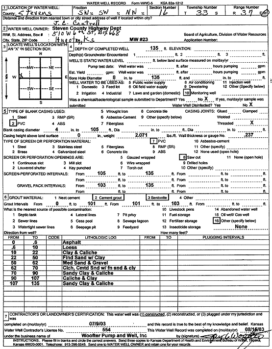
T33S, R37W, Sec. 16 SW SW NW |
Stevens County Highway Dept. | 135 ft. | Monitoring well/observation/piezometer | MW 23 | Constructed | 09-Jul-2003 | Scan | ||
|
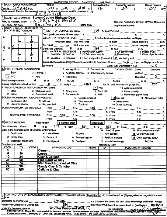
T33S, R37W, Sec. 16 SW SW NW |
Stevens County Highway Dept. | 135 ft. | Monitoring well/observation/piezometer | MW 25 | Constructed | 10-Jul-2003 | Scan | ||
|
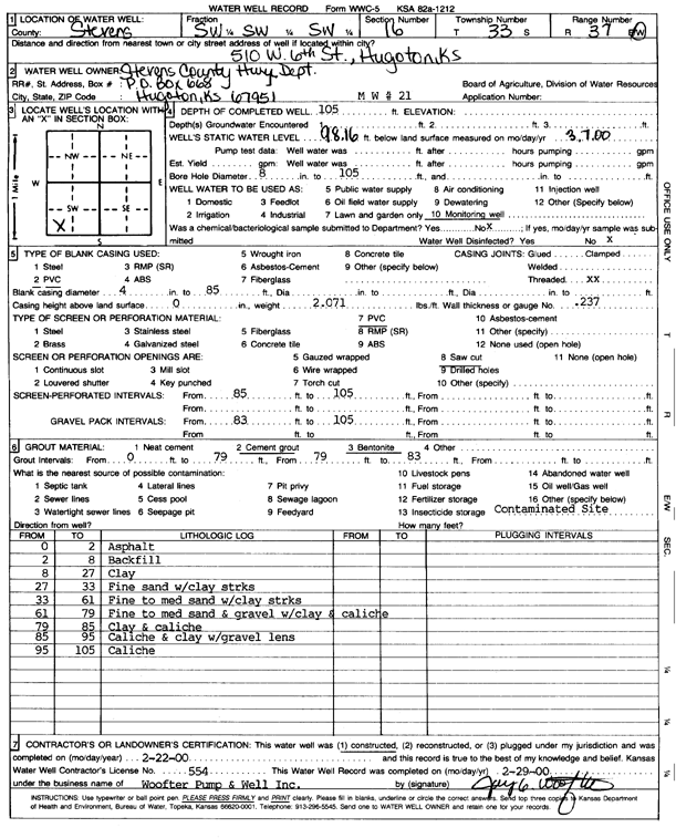
T33S, R37W, Sec. 16 SW SW SW |
Stevens County Highway Dept. | 105 ft. | 98.16 ft. | Monitoring well/observation/piezometer | MW 21 | Constructed | 22-Feb-2000 | Scan | |
|
T33S, R37W, Sec. 16 SW SW NW |
Stevens County Highway Dept. | 174.6 ft. | 174.55 ft. | Monitoring well/observation/piezometer | MW 31 | Plugged | 23-Mar-2023 |
KOLAR |
|
|
T33S, R37W, Sec. 16 SW SW NW |
Stevens County Highway Dept. | 177.65 ft. | Monitoring well/observation/piezometer | MW 29 | Plugged | 28-Mar-2023 |
KOLAR |
||
|
T33S, R37W, Sec. 16 SW SW NW |
Stevens County Highway Dept. | 174.96 ft. | Monitoring well/observation/piezometer | MW 30 | Plugged | 28-Mar-2023 |
KOLAR |
||
|
T33S, R37W, Sec. 16 SW SW NW |
Stevens County Highway Dept. | 100 ft. | 85.67 ft. | Monitoring well/observation/piezometer | MW 1A | Constructed | 31-Mar-1992 | ||
|
T33S, R37W, Sec. 16 NW NW NW |
Stevens County Highway Dept. | 105 ft. | 98.42 ft. | Monitoring well/observation/piezometer | MW 8 | Constructed | 21-Aug-1997 | ||
|
T33S, R37W, Sec. 16 SW SW NW |
Stevens County Highway Dept. | 100 ft. | 86.04 ft. | Monitoring well/observation/piezometer | MW 2A | Constructed | 01-Apr-1992 | ||
|
T33S, R37W, Sec. 16 SW SW NW |
Stevens County Highway Dept. | 100 ft. | 82.22 ft. | Monitoring well/observation/piezometer | MW 4A | Constructed | 09-Apr-1992 | ||
|
T33S, R37W, Sec. 16 SW SW NW |
Stevens County Highway Dept. | 100 ft. | 85.14 ft. | Monitoring well/observation/piezometer | MW 6A | Constructed | 16-Apr-1992 | ||
|
T33S, R37W, Sec. 16 SW SW NW |
Stevens County Highway Dept. | 100 ft. | 84.28 ft. | Monitoring well/observation/piezometer | MW 5A | Constructed | 15-Apr-1992 | ||
|
T33S, R37W, Sec. 16 SW SW NW |
Stevens County Highway Dept. | 100 ft. | 85.29 ft. | Monitoring well/observation/piezometer | MW 3A | Constructed | 06-Apr-1992 | ||
|
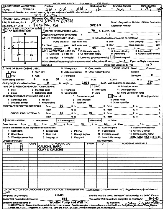
T33S, R37W, Sec. 16 SW SW NW |
Stevens County Highway Dept. | 70 ft. | Environmental Remediation, Soil Vapor Extraction | SVE 5 | Constructed | 09-Jul-2003 | Scan | ||
|
T33S, R37W, Sec. 16 NW NW SE |
Taylor Food Mart 627 | 95 ft. | Monitoring well/observation/piezometer | MW 2 | Plugged | 11-Oct-2006 | |||
|
T33S, R37W, Sec. 16 NW NW SE |
Taylor Food Mart 627 | 94 ft. | 81.44 ft. | Monitoring well/observation/piezometer | MW 2 | Constructed | 19-Mar-1997 | ||
|
T33S, R37W, Sec. 16 NW NW SE |
Taylor Food Mart 627 | 94 ft. | 81.18 ft. | Monitoring well/observation/piezometer | MW 1 | Constructed | 19-Mar-1997 | ||
|
T33S, R37W, Sec. 16 NW NW SE |
Taylor Food Mart 627 | 130 ft. | Monitoring well/observation/piezometer | MW 3 R | Constructed | 11-Oct-2006 | |||
|
T33S, R37W, Sec. 16 NW NW SE |
Taylor Food Mart 627 | 95 ft. | 81.38 ft. | Monitoring well/observation/piezometer | MW 4 | Constructed | 19-Mar-1997 | ||
|
T33S, R37W, Sec. 16 NW NW SE |
Taylor Food Mart 627 | 95 ft. | 81.09 ft. | Monitoring well/observation/piezometer | MW 3 | Constructed | 19-Mar-1995 | ||
|
T33S, R37W, Sec. 16 NW NW SE |
Taylor Food Mart 627 | 128.92 ft. | 111.38 ft. | Monitoring well/observation/piezometer | MW 3 R | Plugged | 18-Mar-2009 | ||
|
T33S, R37W, Sec. 16 NW NW SE |
Taylor Food Mart 627 | 95 ft. | Monitoring well/observation/piezometer | MW 1 | Plugged | 11-Oct-2006 | |||
|
T33S, R37W, Sec. 16 NW NW SE |
Taylor Food Mart 627 | 130.38 ft. | 111 ft. | Monitoring well/observation/piezometer | MW 1 R | Plugged | 18-Mar-2009 | ||
|
T33S, R37W, Sec. 16 NW NW SE |
Taylor Food Mart 627 | 129.49 ft. | 111.4 ft. | Monitoring well/observation/piezometer | MW 2 R | Plugged | 18-Mar-2009 | ||
|
T33S, R37W, Sec. 16 NE NE SW |
Taylor Food Mart 627 | 130 ft. | Monitoring well/observation/piezometer | MW 4 R | Constructed | 10-Oct-2006 | |||
|
T33S, R37W, Sec. 16 NW NW SE |
Taylor Food Mart 627 | 130 ft. | Monitoring well/observation/piezometer | MW 2 R | Constructed | 10-Oct-2006 | |||
|
T33S, R37W, Sec. 16 NW NW SE |
Taylor Food Mart 627 | 130 ft. | Monitoring well/observation/piezometer | MW 1 R | Constructed | 11-Oct-2006 | |||
|
T33S, R37W, Sec. 16 NW NW SE |
Taylor Food Mart 627 | 95 ft. | Monitoring well/observation/piezometer | MW 3 | Plugged | 11-Oct-2006 | |||
|
T33S, R37W, Sec. 16 NW NW SE |
Taylor Food Mart 627 | 129.6 ft. | 110.34 ft. | Monitoring well/observation/piezometer | MW 4 R | Plugged | 18-Mar-2009 | ||
|
T33S, R37W, Sec. 16 NW NW SE |
Taylor Food Mart 627 | 95 ft. | Monitoring well/observation/piezometer | MW 4 | Plugged | 11-Oct-2006 | |||
|
T33S, R37W, Sec. 16 SE SW NE |
USD 210 ECDC | 250 ft. | Heat Pump (Closed Loop/Disposal), Geothermal | Constructed | 17-Mar-2009 | ||||
|
T33S, R37W, Sec. 16 NE SW NE |
Veterans Hall | 150 ft. | 96.5 ft. | Monitoring well/observation/piezometer | MW 32 | Constructed | 05-May-2005 | ||
|
T33S, R37W, Sec. 16 SE NW NE |
Veterans Hall | 146 ft. | 106 ft. | Monitoring well/observation/piezometer | MW 32 | Plugged | 09-Mar-2006 | ||
|
T33S, R37W, Sec. 16 E2 NE SE |
Walkemeyer, Roy | 81 ft. | Domestic | Plugged | 09-Apr-2008 | ||||
|
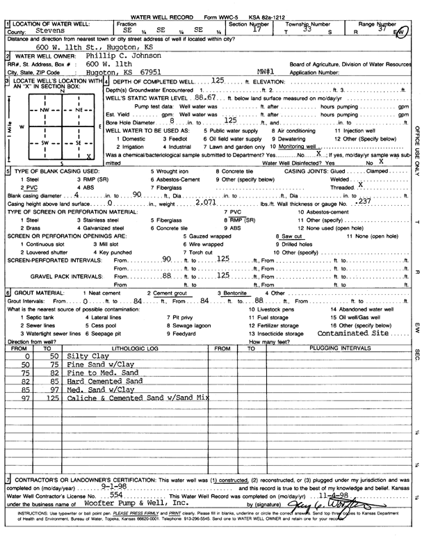
T33S, R37W, Sec. 17 SE SE SE |
Johnson, Phillip C. | 125 ft. | 88.67 ft. | Monitoring well/observation/piezometer | MW 1 | Constructed | 01-Sep-1998 | Scan | |
|
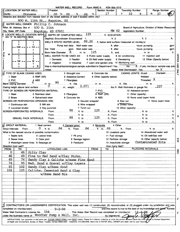
T33S, R37W, Sec. 17 SE SE SE |
Johnson, Phillip C. | 125 ft. | 86.26 ft. | Monitoring well/observation/piezometer | MW 2 | Constructed | 02-Sep-1998 | Scan | |
|
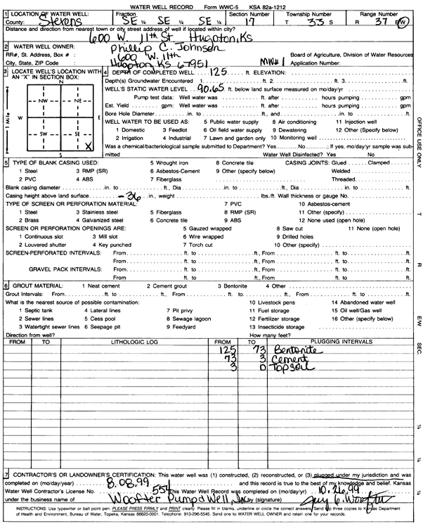
T33S, R37W, Sec. 17 SE SE SE |
Johnson, Phillip C. | 125 ft. | 90.65 ft. | Monitoring well/observation/piezometer | MW 1 | Plugged | 08-Aug-1999 | Scan | |
|
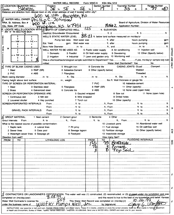
T33S, R37W, Sec. 17 SE SE SE |
Johnson, Phillip C. | 125 ft. | 88.21 ft. | Monitoring well/observation/piezometer | MW 2 | Plugged | 08-Aug-1999 | Scan | |
|
T33S, R37W, Sec. 17 C NW |
Mobil Oil Corp./Roy Walkemeyer | 300 ft. | 118 ft. | 80 gpm. | Oil Field Water Supply | Ratcliff 305 | Constructed | 26-Mar-1984 | |
| View page: < Prev || 31 || 32 || 33 || 34 || 35 || 36 || 37 || 38 || 39 || 40 || Next > | |||||||||