Select location of well to view details.
Click on column heading to sort.
|
|
|
County: Stevens Select location of well to view details. Click on column heading to sort. |
|
|
|
| View page: < Prev || 31 || 32 || 33 || 34 || 35 || 36 || 37 || 38 || 39 || 40 || Next > | |||||||||
| T-R-S | Owner | Well Depth Ascend. Desc. |
Static Water Level Ascend. Desc. |
Est. Yield Ascend. Desc. |
Well Use | Other ID | Action Taken | Completion Date Ascend. Desc. |
Scan? |
|
T33S, R37W, Sec. 17 C NW |
Mobil Oil Corp./Roy Walkemeyer | 300 ft. | 118 ft. | 80 gpm. | Oil Field Water Supply | Ratcliff 3-5 | Plugged | 18-Jun-1984 | |
|
T33S, R37W, Sec. 17 NW SW NW NW |
SCS Engineers | 250 ft. | 213 ft. | Monitoring well/observation/piezometer | Well 4 | Constructed | 20-Oct-2021 |
KOLAR |
|
|
T33S, R37W, Sec. 18 C NW NE |
Anadarko Petroleum Corp. | 360 ft. | 130 ft. | 110 gpm. | Oil Field Water Supply | Ratcliff B-3 | Constructed | 13-Feb-1997 | |
|
T33S, R37W, Sec. 18 SE NW NW |
Anadarko Petroleum Corp. | 220 ft. | 95 ft. | 60 gpm. | Oil Field Water Supply | Ratcliff B-1 | Constructed | 26-Jan-1977 | |
|
T33S, R37W, Sec. 18 SW SW NE |
City of Hugoton | 96.7 ft. | Monitoring well/observation/piezometer | MW 24 | Plugged | 08-Mar-2006 | |||
|
T33S, R37W, Sec. 18 SW SW NE |
City of Hugoton | 130 ft. | Monitoring well/observation/piezometer | MW 25 | Plugged | 09-Mar-2006 | |||
|
T33S, R37W, Sec. 18 SE NW NE |
City of Hugoton | 131 ft. | Monitoring well/observation/piezometer | MW 26 | Plugged | 09-Mar-2006 | |||
|
T33S, R37W, Sec. 18 SE NW NW |
City of Hugoton | 131 ft. | 125 ft. | Monitoring well/observation/piezometer | MW 27 | Plugged | 09-Mar-2006 | ||
|
T33S, R37W, Sec. 18 NW SE SW |
Gabbert and Jones | 380 ft. | 140 ft. | 100 gpm. | Oil Field Water Supply | Ratcliff B-2 | Constructed | 18-Mar-1994 | |
|
T33S, R37W, Sec. 18 NW SE SE |
Moscow Equity | 440 ft. | 104 ft. | Domestic | Constructed | 08-Sep-1988 | |||
|
T33S, R37W, Sec. 18 NE SE NW NE |
SCS Engineers | 250 ft. | 213 ft. | Monitoring well/observation/piezometer | Well 2 | Constructed | 09-Oct-2021 |
KOLAR |
|
|
T33S, R37W, Sec. 18 NE NW SE NE |
SCS Engineers | 250 ft. | 213 ft. | Monitoring well/observation/piezometer | Well 3 | Constructed | 16-Oct-2021 |
KOLAR |
|
|
T33S, R37W, Sec. 18 NE NW NE NE |
SCS Engineers | 250 ft. | 213 ft. | Monitoring well/observation/piezometer | Well 1 | Constructed | 04-Oct-2021 |
KOLAR |
|
|
T33S, R37W, Sec. 19 C SW |
Mobil Oil Corp./Gladys Wilson | 260 ft. | 132 ft. | 100 gpm. | Oil Field Water Supply | Coulter 3 Unit 5 | Constructed | 11-Aug-1984 | |
|
T33S, R37W, Sec. 19 C SW |
Mobil Oil Corp./Gladys Wilson | 260 ft. | 132 ft. | 100 gpm. | Oil Field Water Supply | Coulter 3 Unit 5 | Plugged | 17-Mar-1986 | |
|
T33S, R37W, Sec. 20 NE NE NW |
Anadarko Petroleum Co | 110 ft. | Oil Field Water Supply | King 1-20 | Plugged | 08-Sep-2010 | |||
|
T33S, R37W, Sec. 20 NW SW NE SE |
City of Hugoton | 585 ft. | 202 ft. | 2512 gpm. | Public Water Supply | Well 15 | Constructed | 30-Sep-2015 |
KOLAR |
|
T33S, R37W, Sec. 20 SW SW SW NW |
City of Hugoton | 560 ft. | 225 ft. | Public Water Supply | Plugged | 08-Jan-2019 | |||
|
T33S, R37W, Sec. 20 SW SW SW NW |
City of Hugoton | 560 ft. | 225 ft. | Public Water Supply | Plugged | 18-Jan-2019 | |||
|
T33S, R37W, Sec. 20 SW SW SW NW |
City of Hugoton | 596 ft. | 226 ft. | 1600 gpm. | Public Water Supply | Well 15.25 | Constructed | 11-Aug-2018 |
KOLAR |
|
T33S, R37W, Sec. 20 SW SW SW NW |
City of Hugoton | 560 ft. | 225 ft. | Public Water Supply | Plugged | 18-Jan-2019 | |||
|
T33S, R37W, Sec. 21 C SW SE |
Anadarko Petroleum Corp./Edward Shine | 280 ft. | 105 ft. | 60 gpm. | Oil Field Water Supply | Shine A-2 | Plugged | 16-Mar-1984 | |
|
T33S, R37W, Sec. 21 C SW SW |
Anadarko Petroleum Corp./Edward Shine | 280 ft. | 105 ft. | 60 gpm. | Oil Field Water Supply | Shine A-2 | Constructed | 03-Feb-1984 | |
|
T33S, R37W, Sec. 21 SE NE NE |
City of Hugoton | 125 ft. | 87 ft. | Monitoring well/observation/piezometer | Power Plant | Constructed | 14-Apr-1989 | ||
|
T33S, R37W, Sec. 21 SE NE NE |
City of Hugoton | 125 ft. | 87 ft. | Monitoring well/observation/piezometer | Power Plant | Constructed | 14-Apr-1989 | ||
|
T33S, R37W, Sec. 21 NE NE NE |
City of Hugoton | 125 ft. | 87 ft. | Domestic | Plugged | 13-Nov-1995 | |||
|
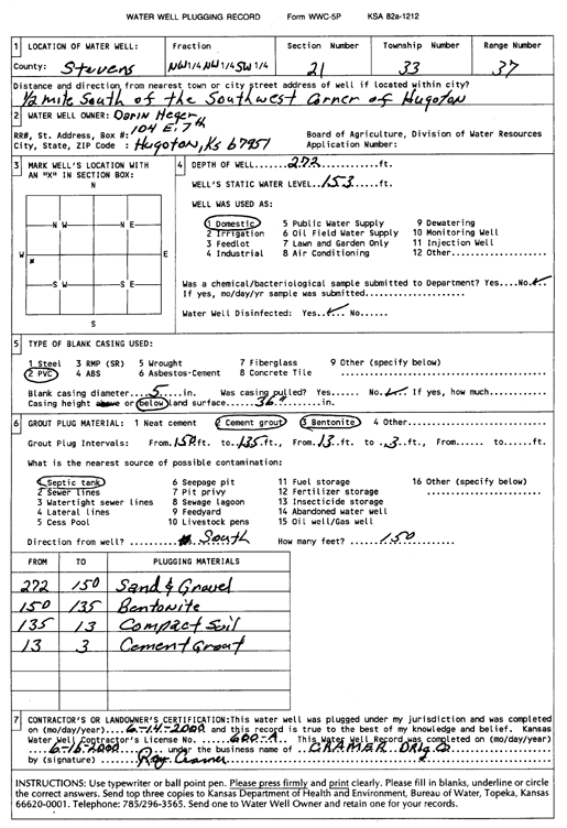
T33S, R37W, Sec. 21 NW NW SW |
Heger, Darin | 272 ft. | 153 ft. | Domestic | Plugged | 14-Jun-2000 | Scan | ||
|
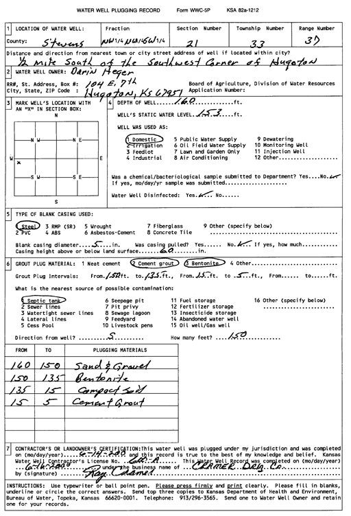
T33S, R37W, Sec. 21 NW NW SW |
Heger, Darin | 160 ft. | 153 ft. | Domestic | Plugged | 14-Jun-2000 | Scan | ||
|
T33S, R37W, Sec. 21 NW NW SW |
Heger, Marlin | 603 ft. | 130 ft. | 1200 gpm. | Irrigation | Constructed | 16-Feb-1991 | ||
|
T33S, R37W, Sec. 21 NW NW SW |
Heger, Marlin | 252 ft. | 122 ft. | Irrigation | Plugged | 04-May-1991 | |||
|
T33S, R37W, Sec. 21 NE NW |
Hugoton Middle School | 305 ft. | 60 ft. | Geothermal, Closed Loop, Vertical | Constructed | 15-Mar-2010 | |||
|
T33S, R37W, Sec. 21 NE SW SE |
Rome, Keith | 200 ft. | Geothermal, Closed Loop, Vertical | Constructed | 29-Nov-2013 | ||||
|
T33S, R37W, Sec. 21 C NE NE |
Schroder, Kim | 280 ft. | 98 ft. | 75 gpm. | Domestic | Constructed | 16-Jul-1985 | ||
|
T33S, R37W, Sec. 21 SW |
Stevens County Commission | 250 ft. | Geothermal, Closed Loop, Vertical | Constructed | 17-May-2010 | ||||
|
T33S, R37W, Sec. 21 NE NE NW |
USD 210 High School | 250 ft. | Heat Pump (Closed Loop/Disposal), Geothermal | Constructed | 17-Mar-2009 | ||||
|
T33S, R37W, Sec. 21 SW SW NW |
Wilson, Gladys | 225 ft. | 90 ft. | 30 gpm. | Domestic | Constructed | 25-May-1981 | ||
|
T33S, R37W, Sec. 22 SE SE SE |
Cox, Jeff | 546 ft. | 173 ft. | Irrigation | Constructed | 24-Sep-2002 | Scan | ||
|
T33S, R37W, Sec. 22 SE SW NE |
Panhandle Eastern | 316 ft. | 120 ft. | Industrial | Plugged | 16-Nov-1994 | |||
|
T33S, R37W, Sec. 22 SE SW NE |
Panhandle Eastern | 214 ft. | Domestic | Plugged | 16-Nov-1994 | ||||
|
T33S, R37W, Sec. 22 SW NE NW |
Schroeder, Jim | 220 ft. | 85 ft. | 30 gpm. | Domestic | Constructed | 20-Aug-1975 | ||
|
T33S, R37W, Sec. 23 C W2 SW |
Berexco Inc. | 300 ft. | 125 ft. | 110 gpm. | Oil Field Water Supply | Constructed | 20-Nov-1990 | ||
|
T33S, R37W, Sec. 23 SW SW NW |
Cox, Jerry | 581 ft. | 157 ft. | Irrigation | Constructed | 15-May-1999 | Scan | ||
|
T33S, R37W, Sec. 24 SW SW NW |
Mid America Cattle Co | 570 ft. | 161 ft. | Irrigation | Constructed | 12-Dec-2002 | Scan | ||
|
T33S, R37W, Sec. 25 SW SE NW |
Knier, Donnie | 260 ft. | 96 ft. | 470 gpm. | Irrigation | Constructed | 29-Oct-1976 | ||
|
T33S, R37W, Sec. 26 SW SW SW |
Carpenter, Karon K. | 573 ft. | 147 ft. | Irrigation | Constructed | 13-Apr-2005 | |||
|
T33S, R37W, Sec. 26 NE NE SE |
Carpenter, Mark | 606 ft. | 246 ft. | Irrigation | Constructed | 03-Feb-2024 |
KOLAR |
||
|
T33S, R37W, Sec. 27 SW NE NE NW |
Archuleta Construction | 210 ft. | Geothermal, Closed Loop, Horizontal | Constructed | 12-Feb-2015 |
KOLAR |
|||
|
T33S, R37W, Sec. 27 SE SE NW SW |
Burrows, Simila | 587 ft. | 225 ft. | 50 gpm. | Domestic, Livestock | Constructed | 26-Sep-2018 | ||
|
T33S, R37W, Sec. 27 NW NW NE |
Gibson, Justin | 575 ft. | Domestic | Constructed | 02-Apr-2014 | ||||
|
T33S, R37W, Sec. 27 C SW |
Mobil Oil Corp./Ruby M. Burrows | 440 ft. | 100 ft. | 100 gpm. | Oil Field Water Supply | Burrows Unit 1 | Constructed | 05-Jun-1987 | |
| View page: < Prev || 31 || 32 || 33 || 34 || 35 || 36 || 37 || 38 || 39 || 40 || Next > | |||||||||