Select location of well to view details.
Click on column heading to sort.
|
|
|
County: Stevens Select location of well to view details. Click on column heading to sort. |
|
|
|
| View page: < Prev || 41 || 42 || 43 || 44 || 45 || 46 || 47 || 48 || 49 || 50 || Next > | |||||||||
| T-R-S | Owner | Well Depth Ascend. Desc. |
Static Water Level Ascend. Desc. |
Est. Yield Ascend. Desc. |
Well Use | Other ID | Action Taken | Completion Date Ascend. Desc. |
Scan? |
|
T34S, R36W, Sec. 11 NW NW NW |
Slawson Drilling Co. | 320 ft. | 185 ft. | 60 gpm. | Oil Field Water Supply | Lewis 1-11 | Constructed | 05-Mar-1988 | |
|
T34S, R36W, Sec. 11 SE NE NW SE |
Wheeler Farms Inc. | 670 ft. | 271 ft. | 1201 gpm. | Irrigation | Constructed | 11-Mar-2016 |
KOLAR |
|
|
T34S, R36W, Sec. 11 SE SE SW |
Wheeler, Lewis | 526 ft. | 200 ft. | 50 gpm. | Domestic | Constructed | 22-Jul-1983 | ||
|
T34S, R36W, Sec. 12 SE NE SE SE |
Lazy T Land and Cattle | 565 ft. | 300 ft. | 60 gpm. | Domestic, Livestock | Constructed | 04-Aug-2015 |
KOLAR |
|
|
T34S, R36W, Sec. 13 NE NW SW |
Beesley, Don and Renee | 718 ft. | 235 ft. | Irrigation | Constructed | 05-Feb-2003 | Scan | ||
|
T34S, R36W, Sec. 13 NE NE NW |
Lanex Drilling/Sidney Thomas | 300 ft. | 155 ft. | 60 gpm. | Oil Field Water Supply | KC Life Ins. 1 | Plugged | 13-May-1983 | |
|
T34S, R36W, Sec. 13 NE NE NW |
Lanex Drilling/Sidney Thomas | 300 ft. | 155 ft. | 60 gpm. | Oil Field Water Supply | KC Life Ins. 1 | Constructed | 02-Feb-1983 | |
|
T34S, R36W, Sec. 13 NE NE SW NE |
Lazy T Land & Cattle LLC | 742 ft. | 375 ft. | 250 gpm. | Irrigation | Constructed | 10-Aug-2015 |
KOLAR |
|
|
T34S, R36W, Sec. 14 SE NE SE |
Mobil Oil Corp. | 650 ft. | 160 ft. | 95 gpm. | Oil Field Water Supply | Constructed | 17-Jul-1987 | ||
|
T34S, R36W, Sec. 14 NE SW SW |
Wheeler Farms Inc. | 700 ft. | 178 ft. | Irrigation | Constructed | 18-Apr-1985 | |||
|
T34S, R36W, Sec. 14 SW SW NW |
Wheeler, Lee | 165 ft. | (unstated)/abandoned | Plugged | 27-Jun-2006 | ||||
|
T34S, R36W, Sec. 14 SW SW NW |
Wheeler, Lee | 482 ft. | 154 ft. | 100 gpm. | Domestic | Constructed | 24-May-1982 | ||
|
T34S, R36W, Sec. 15 SW SW NW |
Davis Trust | 653 ft. | Irrigation | Constructed | 25-Jun-1998 | ||||
|
T34S, R36W, Sec. 15 NW NW NW |
Ensign Operating Co. | 315 ft. | 160 ft. | Oil Field Water Supply | Constructed | 20-Sep-1989 | |||
|
T34S, R36W, Sec. 16 SE SE NW |
Wheeler, Lewis | 637 ft. | 172 ft. | 1800 gpm. | Irrigation | Constructed | 22-Apr-1994 | ||
|
T34S, R36W, Sec. 17 SW SE SW |
Kinser, Donald | 300 ft. | 130 ft. | Domestic | Constructed | 20-Apr-1978 | |||
|
T34S, R36W, Sec. 17 C SW |
Kinser, Wilber | 280 ft. | 150 ft. | 60 gpm. | Domestic | Constructed | 16-Feb-1983 | ||
|
T34S, R36W, Sec. 17 C NW |
Lanex Drilling/Don Kinser | 280 ft. | 134 ft. | 60 gpm. | Oil Field Water Supply | Kinser 1 Unit 2 | Plugged | 12-Sep-1983 | |
|
T34S, R36W, Sec. 17 C NW |
Lanex Drilling/Don Kinser | 280 ft. | 134 ft. | 60 gpm. | Oil Field Water Supply | Kinser 1 Unit 2 | Constructed | 31-May-1983 | |
|
T34S, R36W, Sec. 17 NW SE NE |
Mobil Oil Corp./Don Kinser | 360 ft. | 146 ft. | 100 gpm. | Oil Field Water Supply | Luther O. Card 1 | Constructed | 27-Feb-1987 | |
|
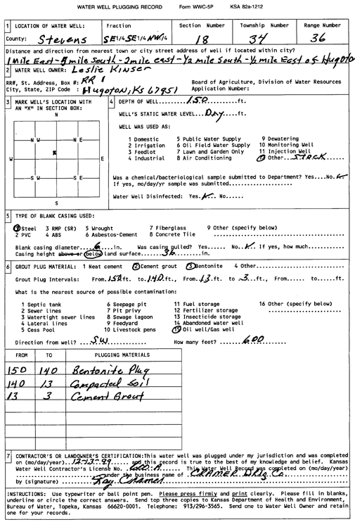
T34S, R36W, Sec. 18 SE SE NW |
Kinser, Leslie | 150 ft. | Domestic, Livestock | Plugged | 13-Dec-1999 | Scan | |||
|
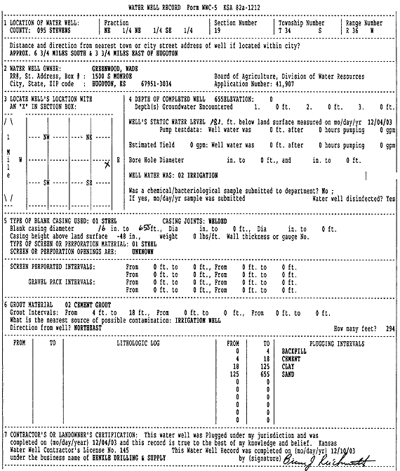
T34S, R36W, Sec. 19 NE NE SE |
Greenwood, Wade | 667 ft. | 178 ft. | Irrigation | Constructed | 21-Dec-2001 | Scan | ||
|
T34S, R36W, Sec. 19 NE NE SE |
Greenwood, Wade | 655 ft. | 181 ft. | Irrigation | Plugged | 04-Dec-2003 | Scan | ||
|
T34S, R36W, Sec. 19 NE NE SE |
Greenwood, Wade D. | 655 ft. | 196 ft. | Irrigation | Constructed | 11-Apr-1996 | |||
|
T34S, R36W, Sec. 19 SW NW NW NW |
L and L Farms | 174 ft. | Domestic, Livestock | Plugged | 30-Apr-2015 | ||||
|
T34S, R36W, Sec. 20 NW NW NE |
Kinser, Louise | 158 ft. | Domestic | Plugged | 31-Jul-1991 | ||||
|
T34S, R36W, Sec. 20 NW SE SW |
Mobil Oil Corp./Leland Morford | 300 ft. | 137 ft. | Oil Field Water Supply | Kinser 2 Unit 4 | Constructed | 14-Mar-1988 | ||
|
T34S, R36W, Sec. 21 SE NW SE |
Wheeler and Son | 657 ft. | 146 ft. | Irrigation | Constructed | 23-Aug-1976 | |||
|
T34S, R36W, Sec. 21 NE NW NE |
Wheeler Farms, Inc. | 699 ft. | 214 ft. | Irrigation | Constructed | 16-Nov-2000 | Scan | ||
|
T34S, R36W, Sec. 22 C NE NW |
Ensign Operating Co. | 340 ft. | 160 ft. | 100 gpm. | Oil Field Water Supply | Constructed | 10-May-1990 | ||
|
T34S, R36W, Sec. 22 SE SE SE |
Thomas, Frank | 413 ft. | 137 ft. | 100 gpm. | Domestic | Constructed | 09-Apr-1982 | ||
|
T34S, R36W, Sec. 22 N2 S2 |
Thomas, Frank | 686 ft. | 202 ft. | 1350 gpm. | Irrigation | Constructed | 23-Jun-1998 | ||
|
T34S, R36W, Sec. 22 SW SW NW |
Wheeler Farms | 584 ft. | 277 ft. | 50 gpm. | Domestic | Constructed | 29-Mar-2022 |
KOLAR |
|
|
T34S, R36W, Sec. 22 NW NE NE |
Wheeler, Lewis | 676 ft. | 204 ft. | 1410 gpm. | Irrigation | Constructed | 15-May-1997 | ||
|
T34S, R36W, Sec. 23 C SW |
Terrol Energy | 280 ft. | 162 ft. | 80 gpm. | Oil Field Water Supply | Ellis 2-23 | Constructed | 17-Aug-1989 | |
|
T34S, R36W, Sec. 23 C SW |
Terrol Energy | 280 ft. | 162 ft. | Oil Field Water Supply | Ellis 2-23 | Plugged | 15-May-1990 | ||
|
T34S, R36W, Sec. 24 SW SW NE |
James, Richard | 708 ft. | 217 ft. | Irrigation | Constructed | 19-Feb-2000 | Scan | ||
|
T34S, R36W, Sec. 24 SW NE NE |
Mobil Oil Corp./Edith Secrest | 350 ft. | 165 ft. | 100 gpm. | Oil Field Water Supply | L. Bivens 1 | Constructed | 23-Aug-1986 | |
|
T34S, R36W, Sec. 24 NE NE NW |
Mobil Oil Corp./James Joslin | 340 ft. | 149 ft. | 80 gpm. | Oil Field Water Supply | Haworth 2 Unit 3 | Constructed | 14-Apr-1984 | |
|
T34S, R36W, Sec. 25 SW SW SW |
Beredco Drilling | 260 ft. | 120 ft. | 100 gpm. | Industrial | Constructed | 30-Aug-1989 | ||
|
T34S, R36W, Sec. 25 NW SE SE |
Beredco Inc. | 300 ft. | 120 ft. | 100 gpm. | Oil Field Water Supply | Constructed | 21-Jan-1990 | ||
|
T34S, R36W, Sec. 25 NW NW SE |
James, Richard | 636 ft. | 201 ft. | 1303 gpm. | Irrigation | Constructed | 25-Sep-1998 | Scan | |
|
T34S, R36W, Sec. 25 SE NW NW |
Mobil Oil Corp./Dorris Morris | 400 ft. | 161 ft. | 100 gpm. | Oil Field Water Supply | Haworth 4 Unit 2 | Constructed | 14-Mar-1987 | |
|
T34S, R36W, Sec. 25 SE NW NW |
Mobil Oil Corp./Dorris Morris | 400 ft. | 161 ft. | 100 gpm. | Oil Field Water Supply | Haworth 4 Unit 2 | Plugged | 31-Jul-1987 | |
|
T34S, R36W, Sec. 25 NE NE NW |
Morris, Dorris | 685 ft. | 140 ft. | Irrigation | Constructed | 17-Nov-1975 | |||
|
T34S, R36W, Sec. 25 SW SW SE |
Northern Natural Gas Co. | 47.7 ft. | Monitoring well/observation/piezometer | B5 | Plugged | 27-Jul-2007 | |||
|
T34S, R36W, Sec. 25 SW SW SE |
Northern Natural Gas Co. | 32.9 ft. | Monitoring well/observation/piezometer | B6 | Plugged | 27-Jul-2007 | |||
|
T34S, R36W, Sec. 25 SW SW SE |
Northern Natural Gas Co. | 32.87 ft. | Monitoring well/observation/piezometer | B7 | Plugged | 27-Jul-2007 | |||
|
T34S, R36W, Sec. 25 SW SW SE |
Northern Natural Gas Co. | 86.9 ft. | Monitoring well/observation/piezometer | B1 | Plugged | 27-Jul-2007 | |||
|
T34S, R36W, Sec. 25 SW SW SE |
Northern Natural Gas Co. | 84 ft. | Monitoring well/observation/piezometer | B3 | Plugged | 27-Jul-2007 | |||
| View page: < Prev || 41 || 42 || 43 || 44 || 45 || 46 || 47 || 48 || 49 || 50 || Next > | |||||||||