Select location of well to view details.
Click on column heading to sort.
|
|
|
County: Sumner Select location of well to view details. Click on column heading to sort. |
|
|
|
| View page: < Prev || 51 || 52 || 53 || 54 || 55 || 56 || 57 || 58 || 59 || 60 || Next > | |||||||||
| T-R-S | Owner | Well Depth Ascend. Desc. |
Static Water Level Ascend. Desc. |
Est. Yield Ascend. Desc. |
Well Use | Other ID | Action Taken | Completion Date Ascend. Desc. |
Scan? |
|
T32S, R1W, Sec. 14 NE NE NE NW |
Former Gas Station | 27.9 ft. | 23.52 ft. | Monitoring well/observation/piezometer | MW 5 | Plugged | 05-Apr-2011 | ||
|
T32S, R1W, Sec. 14 SE NW |
Garver, Gladys | 41 ft. | 25 ft. | Domestic, Lawn and Garden | Constructed | 21-Jun-1991 | |||
|
T32S, R1W, Sec. 14 NW NE NE |
Hadorn, Tom | 47 ft. | 27 ft. | Domestic, Lawn and Garden | Constructed | 26-Aug-1991 | |||
|
T32S, R1W, Sec. 14 NW NW NE SW |
Hart, Nick | 300 ft. | 5 gpm. | Geothermal, Closed Loop, Vertical | Constructed | 03-Aug-2017 |
KOLAR |
||
|
T32S, R1W, Sec. 14 C NE NW |
Holden, Steve | 33 ft. | 11 ft. | Domestic, Lawn and Garden | Constructed | 03-May-1991 | |||
|
T32S, R1W, Sec. 14 E2 NE SW |
Jauregui, A.G. | 44 ft. | Domestic, Lawn and Garden | Constructed | 26-Sep-1991 | ||||
|
T32S, R1W, Sec. 14 SW NE |
Jones, Kenneth | 41 ft. | 21 ft. | Domestic, Lawn and Garden | Constructed | 06-Jul-1991 | |||
|
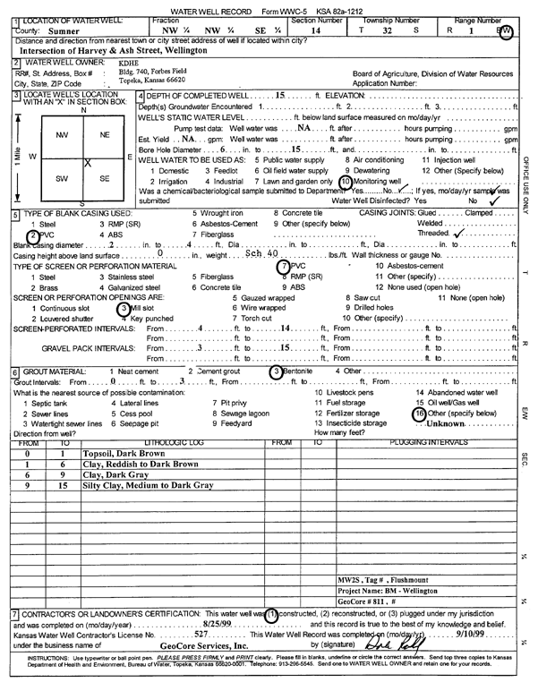
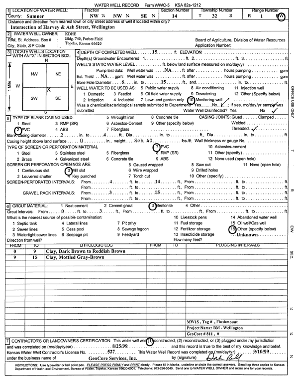
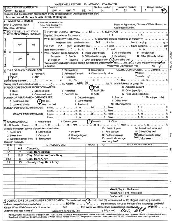
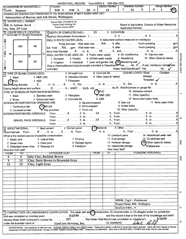
T32S, R1W, Sec. 14 NW NW SE |
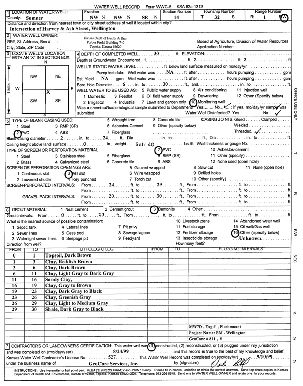
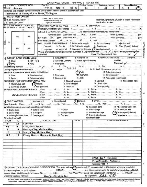
KDHE | 15 ft. | Monitoring well/observation/piezometer | MW 2 S | Constructed | 25-Aug-1999 | Scan | ||
|
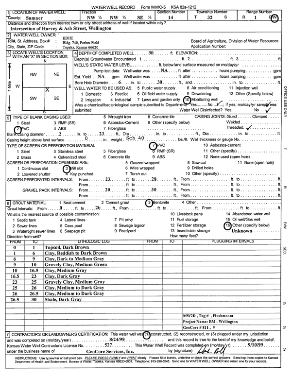
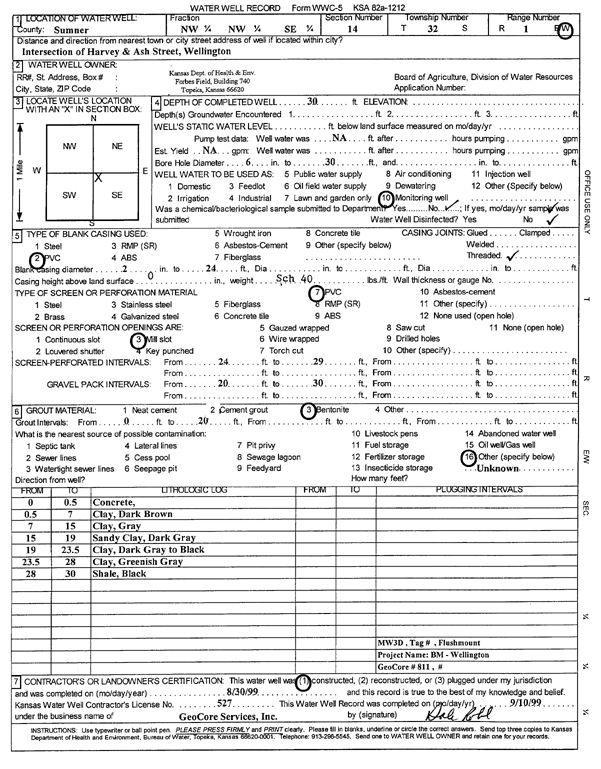
T32S, R1W, Sec. 14 NW NW SE |
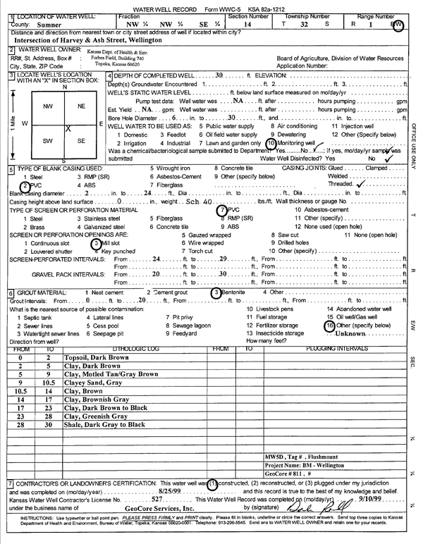
KDHE | 30 ft. | Monitoring well/observation/piezometer | MW 2 D | Constructed | 24-Aug-1999 | Scan | ||
|
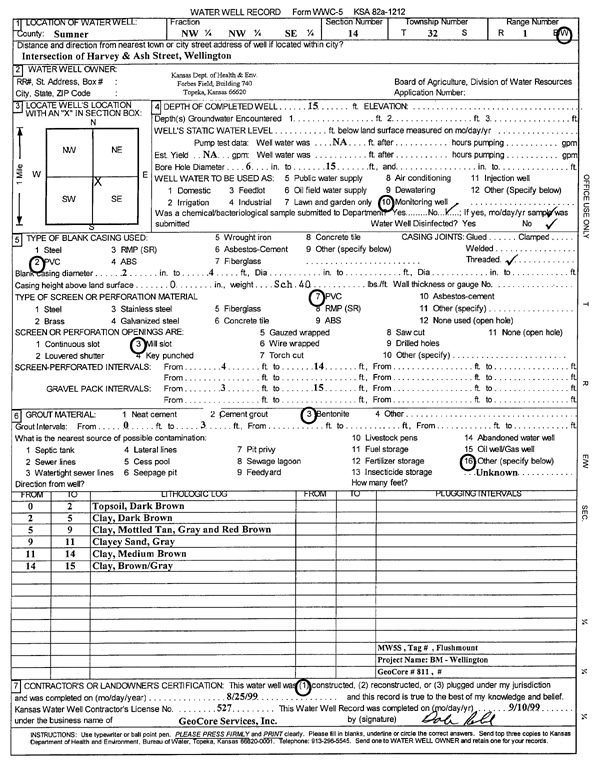
T32S, R1W, Sec. 14 NW NW SE |
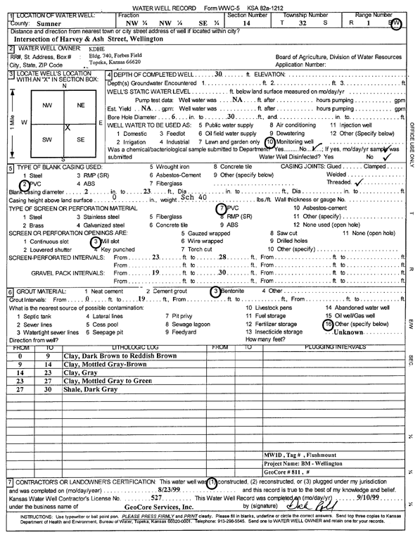
KDHE | 15 ft. | Monitoring well/observation/piezometer | MW 5 S | Constructed | 25-Aug-1999 | Scan | ||
|
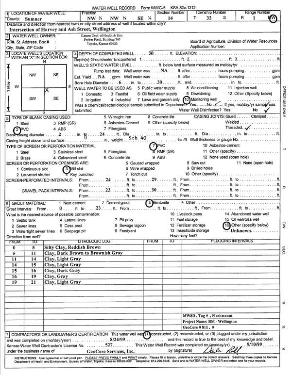
T32S, R1W, Sec. 14 NW NW SE |
KDHE | 30 ft. | Monitoring well/observation/piezometer | MW 8 D | Constructed | 24-Aug-1999 | Scan | ||
|
T32S, R1W, Sec. 14 NW NW NE SW |
KDHE | 24 ft. | 17.6 ft. | Monitoring well/observation/piezometer | DMW 10 | Constructed | 12-May-2015 |
KOLAR |
|
|
T32S, R1W, Sec. 14 NW NE SW |
KDHE | 25 ft. | 17.46 ft. | Monitoring well/observation/piezometer | DMW 7 | Constructed | 21-Aug-2014 | ||
|
T32S, R1W, Sec. 14 NW NE SW |
KDHE | 25 ft. | 19.52 ft. | Monitoring well/observation/piezometer | DMW 4 | Constructed | 22-Aug-2014 | ||
|
T32S, R1W, Sec. 14 SW SW SE NW |
KDHE | 20.3 ft. | 15.39 ft. | Monitoring well/observation/piezometer | DMW 12 | Constructed | 12-May-2015 |
KOLAR |
|
|
T32S, R1W, Sec. 14 NW NE SW |
KDHE | 25 ft. | 18.31 ft. | Monitoring well/observation/piezometer | DMW 8 | Constructed | 21-Aug-2014 | ||
|
T32S, R1W, Sec. 14 SW SE NW |
KDHE | 25 ft. | 17.28 ft. | Monitoring well/observation/piezometer | DMW 6 | Constructed | 21-Aug-2014 | ||
|
T32S, R1W, Sec. 14 SW SE NW |
KDHE | 25 ft. | 21.34 ft. | Monitoring well/observation/piezometer | DMW 1 | Constructed | 20-Aug-2014 | ||
|
T32S, R1W, Sec. 14 SW SE NW |
KDHE | 25 ft. | 19.03 ft. | Monitoring well/observation/piezometer | DMW 9 | Constructed | 22-Aug-2014 | ||
|
T32S, R1W, Sec. 14 NW NE SW |
KDHE | 25 ft. | 18.36 ft. | Monitoring well/observation/piezometer | DMW 5 | Constructed | 22-Aug-2014 | ||
|
T32S, R1W, Sec. 14 SW SE NW |
KDHE | 25 ft. | 18.18 ft. | Monitoring well/observation/piezometer | DMW 3 | Constructed | 22-Aug-2014 | ||
|
T32S, R1W, Sec. 14 SW SE NW |
KDHE | 25 ft. | 18.97 ft. | Monitoring well/observation/piezometer | DMW 2 | Constructed | 21-Aug-2014 | ||
|
T32S, R1W, Sec. 14 SW SW SE NW |
KDHE | 21 ft. | 18.06 ft. | Monitoring well/observation/piezometer | DMW 13 | Constructed | 13-May-2015 |
KOLAR |
|
|
T32S, R1W, Sec. 14 SE SW SE NW |
KDHE | 25 ft. | 18.31 ft. | Monitoring well/observation/piezometer | DMW 14 | Constructed | 13-May-2015 |
KOLAR |
|
|
T32S, R1W, Sec. 14 SW SW SE NW |
KDHE | 21.5 ft. | 17.3 ft. | Monitoring well/observation/piezometer | DMW 11 | Constructed | 13-May-2015 |
KOLAR |
|
|
T32S, R1W, Sec. 14 NW NW SE |
KDHE | 15 ft. | Monitoring well/observation/piezometer | MW 1 S | Constructed | 25-Aug-1999 | Scan | ||
|
T32S, R1W, Sec. 14 NW NW SE |
KDHE | 30 ft. | Monitoring well/observation/piezometer | MW 3 D | Constructed | 30-Aug-1999 | Scan | ||
|
T32S, R1W, Sec. 14 NW NW SE |
KDHE | 15 ft. | Monitoring well/observation/piezometer | MW 4 S | Constructed | 26-Aug-1999 | Scan | ||
|
T32S, R1W, Sec. 14 NW NW SE |
KDHE | 15 ft. | Monitoring well/observation/piezometer | MW 8 S | Constructed | 25-Aug-1999 | Scan | ||
|
T32S, R1W, Sec. 14 NW NW SE |
KDHE | 30 ft. | Monitoring well/observation/piezometer | MW 7 D | Constructed | 24-Aug-1999 | Scan | ||
|
T32S, R1W, Sec. 14 NW NW SE |
KDHE | 15 ft. | Monitoring well/observation/piezometer | MW 3 S | Constructed | 26-Aug-1999 | Scan | ||
|
T32S, R1W, Sec. 14 NW NW SE |
KDHE | 30 ft. | Monitoring well/observation/piezometer | MW 4 D | Constructed | 31-Aug-1999 | Scan | ||
|
T32S, R1W, Sec. 14 NW NW SE |
KDHE | 30 ft. | Monitoring well/observation/piezometer | MW 5 D | Constructed | 25-Aug-1999 | Scan | ||
|
T32S, R1W, Sec. 14 NW NW SE |
KDHE | 30 ft. | Monitoring well/observation/piezometer | MW 1 D | Constructed | 23-Aug-1999 | Scan | ||
|
T32S, R1W, Sec. 14 NW NW SE |
KDHE | 30 ft. | Monitoring well/observation/piezometer | MW 6 D | Constructed | 30-Aug-1999 | Scan | ||
|
T32S, R1W, Sec. 14 NW NW SE |
KDHE | 15 ft. | Monitoring well/observation/piezometer | MW 6 S | Constructed | 26-Aug-1999 | Scan | ||
|
T32S, R1W, Sec. 14 NW NW SE |
KDHE | 15 ft. | Monitoring well/observation/piezometer | MW 7 S | Constructed | 25-Aug-1999 | Scan | ||
|
T32S, R1W, Sec. 14 NE NE NE NW |
KDHE-BER | 30 ft. | Monitoring well/observation/piezometer | MW 10 | Constructed | 28-Feb-2012 | |||
|
T32S, R1W, Sec. 14 NE NE NE NW |
KDHE-BER | 35 ft. | 27.25 ft. | Monitoring well/observation/piezometer | MW 16 | Constructed | 04-Mar-2014 | ||
|
T32S, R1W, Sec. 14 NE NE NE NW |
KDHE-BER | 30 ft. | Monitoring well/observation/piezometer | MW 8 | Constructed | 28-Feb-2012 | |||
|
T32S, R1W, Sec. 14 NE NE NE NW |
KDHE-BER | 30 ft. | 24.35 ft. | Monitoring well/observation/piezometer | MW 17 | Constructed | 05-Mar-2014 | ||
|
T32S, R1W, Sec. 14 NE NE NE NW |
KDHE-BER | 30 ft. | Monitoring well/observation/piezometer | MW 7 | Constructed | 29-Feb-2012 | |||
|
T32S, R1W, Sec. 14 NE NE NE NW |
KDHE-BER | 35 ft. | Monitoring well/observation/piezometer | MW 11 | Constructed | 29-Feb-2012 | |||
|
T32S, R1W, Sec. 14 NE NE NE NW |
KDHE-BER | 30 ft. | Monitoring well/observation/piezometer | MW 9 | Constructed | 28-Feb-2012 | |||
|
T32S, R1W, Sec. 14 NE NE NW |
KDHE-BER | 29.55 ft. | 23.25 ft. | Monitoring well/observation/piezometer | MW 17 | Plugged | 15-Feb-2022 |
KOLAR |
|
|
T32S, R1W, Sec. 14 NE NE NW |
KDHE-BER | 34.45 ft. | 16.15 ft. | Monitoring well/observation/piezometer | MW 16 | Plugged | 15-Feb-2022 |
KOLAR |
|
|
T32S, R1W, Sec. 14 NW NW SE |
KDHE-BER | 14 ft. | 4.37 ft. | Monitoring well/observation/piezometer | MW 12 S | Constructed | 22-Jun-2011 | ||
|
T32S, R1W, Sec. 14 NW NW SE |
KDHE-BER | 14.5 ft. | 5.7 ft. | Monitoring well/observation/piezometer | MW 9 S | Constructed | 22-Jun-2011 | ||
|
T32S, R1W, Sec. 14 NW NW SE |
KDHE-BER | 27.5 ft. | 5.58 ft. | Monitoring well/observation/piezometer | MW 9 D | Constructed | 22-Jun-2011 | ||
|
T32S, R1W, Sec. 14 NW NW SE |
KDHE-BER | 14 ft. | 5.14 ft. | Monitoring well/observation/piezometer | MW 11 S | Constructed | 22-Jun-2011 | ||
| View page: < Prev || 51 || 52 || 53 || 54 || 55 || 56 || 57 || 58 || 59 || 60 || Next > | |||||||||