Select location of well to view details.
Click on column heading to sort.
|
|
|
County: Thomas Select location of well to view details. Click on column heading to sort. |
|
|
|
| View page: < Prev || 21 || 22 || 23 || 24 || 25 || 26 || 27 || 28 || 29 || 30 || Next > | |||||||||
| T-R-S | Owner | Well Depth Ascend. Desc. |
Static Water Level Ascend. Desc. |
Est. Yield Ascend. Desc. |
Well Use | Other ID | Action Taken | Completion Date Ascend. Desc. |
Scan? |
|
T8S, R32W, Sec. 26 SW NW NE NW |
Wilson, Brent | 250 ft. | 180 ft. | 30 gpm. | Domestic, Livestock | Constructed | 12-Dec-2019 |
KOLAR |
|
|
T8S, R32W, Sec. 27 SE SE NE |
Ryan, Clara E. | 226 ft. | 124 ft. | Domestic | Constructed | 06-Feb-1986 | |||
|
T8S, R32W, Sec. 27 NW SW SE |
Ryan, Dennis | 220 ft. | 123 ft. | 800 gpm. | Irrigation | Constructed | 10-Nov-1975 | ||
|
T8S, R32W, Sec. 28 NE NE SW |
Gallaway Drilling | 218 ft. | 130 ft. | 35 gpm. | Oil Field Water Supply | Constructed | 01-Jan-1991 | ||
|
T8S, R32W, Sec. 29 NW NW SW |
Saddler, Doyle | 199 ft. | 103 ft. | Oil Field Water Supply | Constructed | 15-Mar-1986 | |||
|
T8S, R32W, Sec. 29 C NW SW |
Saddler, Doyle | 200 ft. | 152 ft. | Oil Field Water Supply | Rig 7 Saddler 1 | Plugged | 29-Mar-1986 | ||
|
T8S, R32W, Sec. 30 C SE NE |
Leak, Bernard | 192 ft. | 165 ft. | Oil Field Water Supply | Plugged | 12-Nov-1986 | |||
|
T8S, R32W, Sec. 30 NE SE NE |
Leak, Bernard | 192 ft. | 121 ft. | Oil Field Water Supply | Constructed | 28-Oct-1986 | |||
|
T8S, R32W, Sec. 30 NW NE NW |
Riddle, Jeanne and McCartney, Marilyn | Domestic | Plugged | 21-Aug-1989 | |||||
|
T8S, R32W, Sec. 30 NE NE NE |
Saddler, Doyle | 200 ft. | Oil Field Water Supply | Constructed | 26-Mar-2007 | ||||
|
T8S, R32W, Sec. 32 SW SW SW |
Saddler, Cyril H. and Twila P. | 135 ft. | 130 ft. | Domestic | Plugged | 28-Sep-1989 | |||
|
T8S, R32W, Sec. 32 SE NW SW |
Saddler, Cyril H. and Twila P. | 125 ft. | Domestic | Plugged | 28-Sep-1989 | ||||
|
T8S, R32W, Sec. 32 SW NW NW |
Saddler, Dayle | 190 ft. | 135 ft. | Domestic | Constructed | 08-Apr-1988 | |||
|
T8S, R32W, Sec. 32 SW SW NW |
Saddler, Doyle E | 134 ft. | 130 ft. | Domestic | Plugged | 30-Sep-1989 | |||
|
T8S, R32W, Sec. 32 SW SW NW |
Saddler, Doyle E | 125 ft. | Domestic | Plugged | 30-Sep-1989 | ||||
|
T8S, R32W, Sec. 32 NE NE SE |
Siebert, Henry | 170 ft. | 120 ft. | 270 gpm. | Irrigation | Constructed | 03-Jun-1976 | ||
|
T8S, R32W, Sec. 32 NE NE SE |
Siebert, Henry | 166 ft. | 108 ft. | 259 gpm. | Irrigation | Constructed | 06-Dec-1976 | ||
|
T8S, R32W, Sec. 33 SE SE SE |
Cersovsky Jr., Lloyd | 170 ft. | Domestic | Constructed | 22-Aug-2008 | ||||
|
T8S, R32W, Sec. 33 SW SE SE |
Cersovsky, Lloyd and Cindy | 60 ft. | Domestic | Plugged | 16-Apr-1989 | ||||
|
T8S, R32W, Sec. 33 NW SW NW |
Wilson, Lloyd G. | 170 ft. | 130 ft. | Domestic | Constructed | 29-Dec-1976 | |||
|
T8S, R32W, Sec. 34 NE SE SE |
Sowers, James | 200 ft. | 99 ft. | Domestic | Constructed | 26-Mar-1981 | |||
|
T8S, R32W, Sec. 36 NE NE NE |
Flanagin, John D. and Margaret E. | 149 ft. | Domestic | Plugged | 18-Feb-1991 | ||||
|
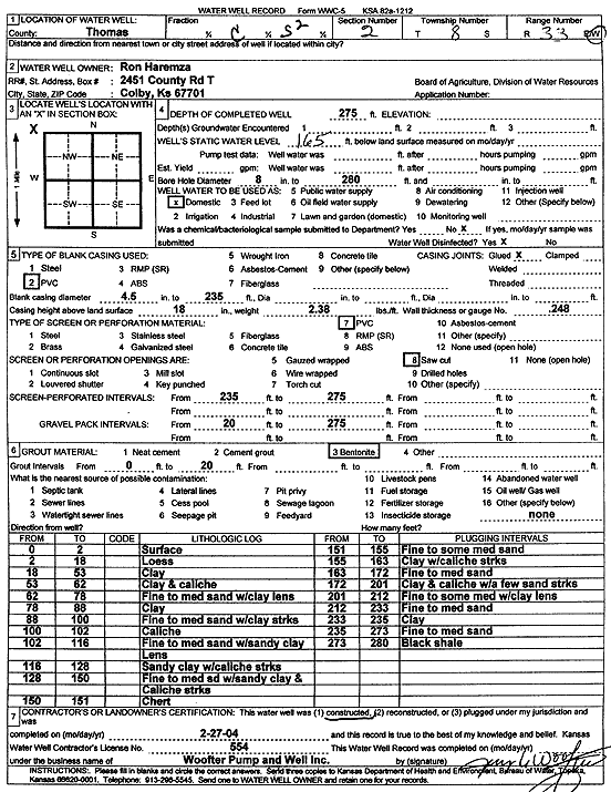
T8S, R33W, Sec. 2 C S2 |
Ron Haremza | 275 ft. | 165 ft. | Domestic | Constructed | 27-Feb-2004 | Scan | ||
|
T8S, R33W, Sec. 3 SW SW SW |
City of Colby | 281 ft. | 172 ft. | Public Water Supply | Well No. 15 | Constructed | 02-Mar-2005 | ||
|
T8S, R33W, Sec. 3 NW |
Engelhardt, Kenneth | 150 ft. | Domestic | Plugged | 15-Oct-2015 | ||||
|
T8S, R33W, Sec. 4 SW NE NW |
Agriliance, LLC | 200 ft. | 165 ft. | Monitoring well/observation/piezometer | MW 2 | Constructed | 18-Nov-2010 | ||
|
T8S, R33W, Sec. 4 SW NE NW |
Agriliance, LLC | 160 ft. | Monitoring well/observation/piezometer | Constructed | 21-May-2010 | ||||
|
T8S, R33W, Sec. 4 SW NE NW |
Agriliance, LLC | 200 ft. | 167.05 ft. | Monitoring well/observation/piezometer | MW 1 | Plugged | 19-May-2020 | ||
|
T8S, R33W, Sec. 4 SW NE NW |
Agriliance, LLC | 200 ft. | Monitoring well/observation/piezometer | MW 1 | Constructed | 18-Nov-2010 | |||
|
T8S, R33W, Sec. 4 SW NE NW |
Agriliance, LLC | 203 ft. | 170.6 ft. | Monitoring well/observation/piezometer | MW 2 | Plugged | 19-May-2020 | ||
|
T8S, R33W, Sec. 4 SE NW NW |
Agriliance, LLC | 160 ft. | Monitoring well/observation/piezometer | Constructed | 21-May-2010 | ||||
|
T8S, R33W, Sec. 4 NW NE NW |
Agriliance, LLC | 160 ft. | Monitoring well/observation/piezometer | Constructed | 19-May-2010 | ||||
|
T8S, R33W, Sec. 4 NE SW NE |
City of Colby | 195 ft. | 141 ft. | Monitoring well/observation/piezometer | Well 1 | Constructed | 19-Feb-1987 | ||
|
T8S, R33W, Sec. 4 SE SE NE |
City of Colby | 188.06 ft. | Monitoring well/observation/piezometer | MW 4 | Plugged | 10-Dec-2008 | |||
|
T8S, R33W, Sec. 4 SE SE NE |
City of Colby | 200 ft. | 194.22 ft. | Monitoring well/observation/piezometer | MW 3 | Plugged | 16-Apr-2019 | ||
|
T8S, R33W, Sec. 4 SE SE NE |
City of Colby | 200 ft. | 167 ft. | Monitoring well/observation/piezometer | Well 3 | Constructed | 20-Feb-1987 | ||
|
T8S, R33W, Sec. 4 SW SE NE |
City of Colby | 275 ft. | 174 ft. | Monitoring well/observation/piezometer | Well 2 | Constructed | 23-Feb-1987 | ||
|
T8S, R33W, Sec. 4 SE SE NE |
City of Colby | 189.7 ft. | Monitoring well/observation/piezometer | MW 5 | Plugged | 10-Dec-2008 | |||
|
T8S, R33W, Sec. 4 NW NW NW |
Colby Implement | 150 ft. | Domestic | Plugged | 23-Oct-1993 | ||||
|
T8S, R33W, Sec. 4 NW NW NW |
Colby Implement | 260 ft. | 151 ft. | Domestic | Plugged | 15-Oct-1993 | |||
|
T8S, R33W, Sec. 4 NW NW NW NE |
Engelhardt, Ken | 272 ft. | 210 ft. | 25 gpm. | Domestic | Constructed | 15-Jul-2015 | ||
|
T8S, R33W, Sec. 4 NE SE NW NW |
Hi-Plains Co-op | 160 ft. | Monitoring well/observation/piezometer | B 3 | Plugged | 07-Jun-2018 | |||
|
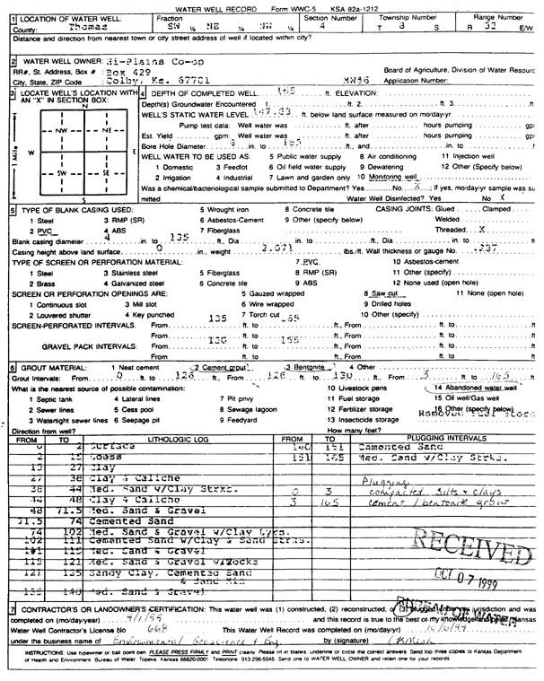
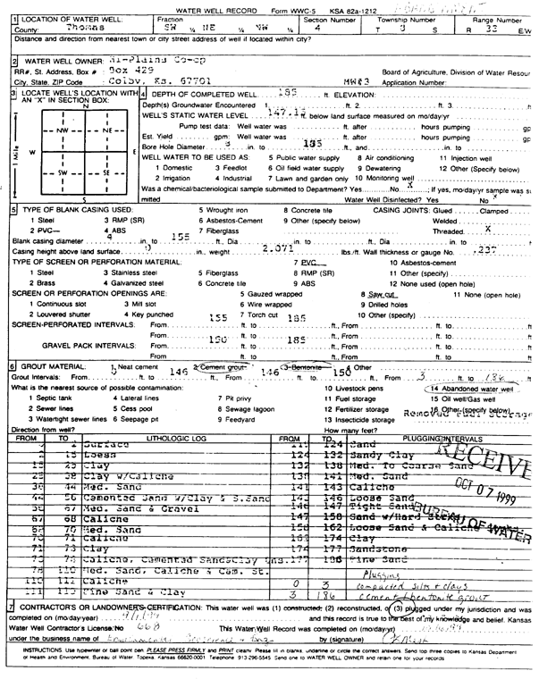
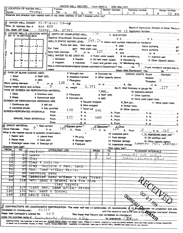
T8S, R33W, Sec. 4 SW NE NW |
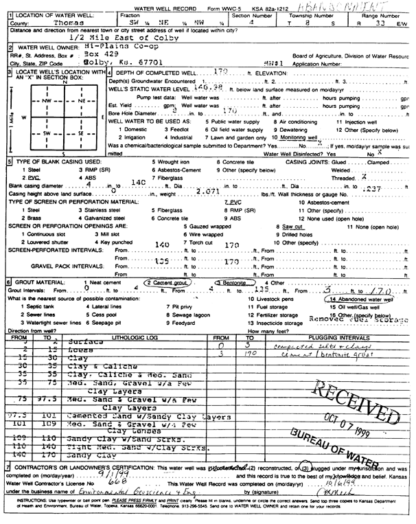
Hi-Plains Co-op | 185 ft. | 147.15 ft. | Monitoring well/observation/piezometer | MW 3 | Constructed | 20-Oct-1996 | ||
|
T8S, R33W, Sec. 4 SW NE NW |
Hi-Plains Co-op | 165 ft. | 147.83 ft. | Monitoring well/observation/piezometer | MW 6 | Plugged | 01-Sep-1999 | Scan | |
|
T8S, R33W, Sec. 4 SW NE NW |
Hi-Plains Co-op | 185 ft. | 147.15 ft. | Monitoring well/observation/piezometer | MW 3 | Plugged | 01-Sep-1999 | Scan | |
|
T8S, R33W, Sec. 4 SW NE NW |
Hi-Plains Co-op | 160 ft. | 145.35 ft. | Monitoring well/observation/piezometer | MW 2 | Plugged | 01-Sep-1999 | Scan | |
|
T8S, R33W, Sec. 4 SW NE NW |
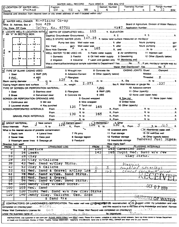
Hi-Plains Co-op | 165 ft. | 147.25 ft. | Monitoring well/observation/piezometer | MW 7 | Plugged | 01-Sep-1999 | Scan | |
|
T8S, R33W, Sec. 4 SW NE NW |
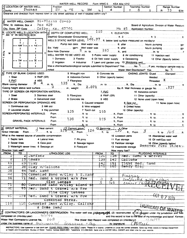
Hi-Plains Co-op | 165 ft. | 146.97 ft. | Monitoring well/observation/piezometer | MW 5 | Plugged | 01-Sep-1999 | Scan | |
|
T8S, R33W, Sec. 4 SW NE NW |
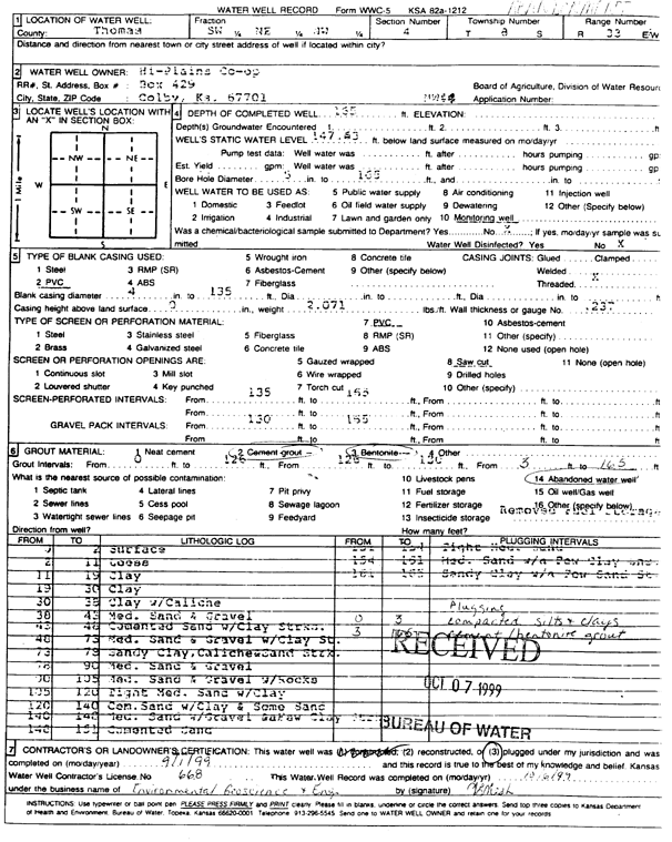
Hi-Plains Co-op | 165 ft. | 147.63 ft. | Monitoring well/observation/piezometer | MW 4 | Plugged | 01-Sep-1999 | Scan | |
|
T8S, R33W, Sec. 4 SW NE NW |
Hi-Plains Co-op | 170 ft. | 146.98 ft. | Monitoring well/observation/piezometer | MW 1 | Plugged | 01-Sep-1999 | Scan | |
| View page: < Prev || 21 || 22 || 23 || 24 || 25 || 26 || 27 || 28 || 29 || 30 || Next > | |||||||||