Select location of well to view details.
Click on column heading to sort.
|
|
|
County: Thomas Select location of well to view details. Click on column heading to sort. |
|
|
|
| View page: < Prev || 31 || 32 || 33 || 34 || 35 || 36 || 37 || 38 || 39 || 40 || Next > | |||||||||
| T-R-S | Owner | Well Depth Ascend. Desc. |
Static Water Level Ascend. Desc. |
Est. Yield Ascend. Desc. |
Well Use | Other ID | Action Taken | Completion Date Ascend. Desc. |
Scan? |
|
T8S, R34W, Sec. 32 NW NW NE |
Smith, Mary B. | Domestic | Plugged | 19-Apr-1990 | |||||
|
T8S, R34W, Sec. 33 NW NW SW |
Calliham, Bessie Dawes | 156.9 ft. | Domestic | Plugged | 08-Jun-1989 | ||||
|
T8S, R34W, Sec. 36 E2 NW NE NE |
Ready Mix, Southwest | 285 ft. | 205 ft. | 75 gpm. | Industrial | Constructed | 17-Aug-2018 |
KOLAR |
|
|
T8S, R34W, Sec. 36 SW NE NE |
Rohrbough, Claude | 150 ft. | Domestic | Plugged | 05-Jun-2007 | ||||
|
T8S, R34W, Sec. 36 SE SE NE |
Rohrbough, Elva | 282 ft. | 132 ft. | 60 gpm. | Domestic | Constructed | 18-Apr-1975 | ||
|
T8S, R34W, Sec. 36 NW SE NW |
Rohrbough, Elva F. and Velma L. | 110 ft. | Domestic | Plugged | 09-Sep-1989 | ||||
|
T8S, R34W, Sec. 36 SW SW SE |
Steele, Paul | 266 ft. | 166 ft. | 1800 gpm. | Irrigation | Constructed | 17-Dec-1981 | ||
|
T8S, R35W, Sec. 1 SW SW NW |
Winegar, Merle J. | Domestic | Plugged | 03-Nov-1987 | |||||
|
T8S, R35W, Sec. 2 NW SE SW |
Arnberger, Rod and Terri | 150 ft. | Domestic | Plugged | 02-Aug-1988 | ||||
|
T8S, R35W, Sec. 2 SW SE SW |
Bellamy, Greg | 215 ft. | 160 ft. | 20 gpm. | Domestic | Constructed | 13-Oct-2022 |
KOLAR |
|
|
T8S, R35W, Sec. 2 NW NW SE SW |
Brocklehurst, Mike | 151 ft. | 148 ft. | Domestic | Plugged | 26-Jan-2016 | |||
|
T8S, R35W, Sec. 2 SW SE SW |
Dean, Art | 210 ft. | 145 ft. | Domestic | Constructed | 15-Aug-1997 | |||
|
T8S, R35W, Sec. 2 SW SE SW |
Deaver, A.D. | 200 ft. | 145 ft. | Domestic | Constructed | 01-Apr-1995 | |||
|
T8S, R35W, Sec. 2 SE SE SW |
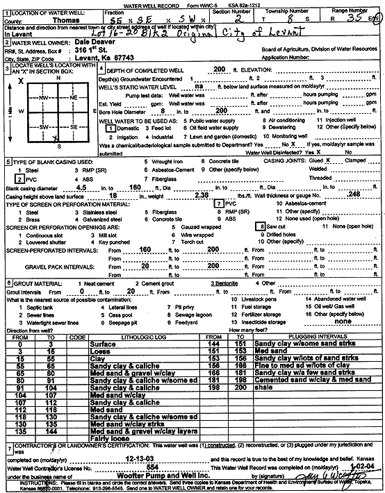
Deaver, Dale | 200 ft. | Domestic | Constructed | 13-Dec-2003 | Scan | |||
|
T8S, R35W, Sec. 2 C NW |
Finley, Jeff | 195 ft. | 104 ft. | Domestic | Constructed | 08-Aug-1977 | |||
|
T8S, R35W, Sec. 2 NE SE SW |
Hamilton II, C.W. | 100 ft. | Domestic | Plugged | 15-Sep-1988 | ||||
|
T8S, R35W, Sec. 2 SE SE SW |
Hatfield, Eldon | 213 ft. | 132 ft. | 25 gpm. | Domestic | Constructed | 23-Jul-1988 | ||
|
T8S, R35W, Sec. 2 SE SE SW |
Hatfield, Lowell | 197 ft. | 143 ft. | Domestic | Reconstructed | 08-Oct-1980 | |||
|
T8S, R35W, Sec. 2 NW SE SW |
Hein, Selma | 90 ft. | Domestic | Plugged | 26-Mar-1989 | ||||
|
T8S, R35W, Sec. 2 NE NE SW |
Hi-Plains Coop | 220 ft. | Domestic | Constructed | 12-Apr-2012 | ||||
|
T8S, R35W, Sec. 2 SW NE SE |
Hillary, Thomas L. | 225 ft. | 155 ft. | Domestic | Constructed | 30-May-1977 | |||
|
T8S, R35W, Sec. 2 SE SE SW |
Hillery, Tom | 210 ft. | 175 ft. | Domestic | Constructed | 19-Aug-1991 | |||
|
T8S, R35W, Sec. 2 SW NE SW |
Holsman, Kevin J. | 150 ft. | Domestic | Plugged | 31-Jul-1988 | ||||
|
T8S, R35W, Sec. 2 SE NE SW |
Jones, Sidney M. | Domestic | Plugged | 05-Oct-1988 | |||||
|
T8S, R35W, Sec. 2 SW SE SW |
Levant Community Church | Domestic | Plugged | 10-Apr-1988 | |||||
|
T8S, R35W, Sec. 2 SW SW SE SW |
Levant Community Church | 205 ft. | 155 ft. | 30 gpm. | Domestic | Constructed | 28-Nov-2016 |
KOLAR |
|
|
T8S, R35W, Sec. 2 SE SE SW |
Marrs, Eugene | 212 ft. | 147 ft. | 50 gpm. | Domestic | Constructed | 06-Jul-1977 | ||
|
T8S, R35W, Sec. 2 NW SE SW |
Mason, Larry D. | 100 ft. | Domestic | Plugged | 18-Jan-1988 | ||||
|
T8S, R35W, Sec. 2 NW NE SW |
Miller, Willard Jr. | 147 ft. | Domestic | Plugged | 30-May-2008 | ||||
|
T8S, R35W, Sec. 2 NE SE SW |
Rush, Francis | 126 ft. | Domestic | Plugged | 13-Sep-1988 | ||||
|
T8S, R35W, Sec. 2 NW SE SW |
Schuette, Mark | 136 ft. | 131 ft. | Domestic | Plugged | 26-Feb-1989 | |||
|
T8S, R35W, Sec. 2 SE SW |
Seemann, Ernie | 220 ft. | 105 ft. | Domestic | Constructed | 12-Apr-1978 | |||
|
T8S, R35W, Sec. 2 SE NE SW |
Seemann, Ernst G. and Rosalie | 150 ft. | 140 ft. | Domestic | Plugged | 07-Aug-1988 | |||
|
T8S, R35W, Sec. 2 SE NE SW |
Shepard, Gerald and Ila | 160 ft. | Domestic | Plugged | 23-Mar-1988 | ||||
|
T8S, R35W, Sec. 2 SW NW NW |
Shields, Williams | 112 ft. | 110 ft. | Domestic | Plugged | 15-May-2009 | |||
|
T8S, R35W, Sec. 2 NW NW NW |
Shroeder, Otto | 208 ft. | 138 ft. | 25 gpm. | Domestic | Constructed | 15-Aug-2013 | ||
|
T8S, R35W, Sec. 2 NE SE SW |
Touslee, Delbert | 152 ft. | 6 ft. | Domestic | Plugged | 28-Mar-1988 | |||
|
T8S, R35W, Sec. 2 NE SE SW |
Touslee, Delbert | 154 ft. | 8 ft. | Domestic | Plugged | 28-Mar-1988 | |||
|
T8S, R35W, Sec. 2 SE NE SW |
Tubbs, Jimmie | 120 ft. | Domestic | Plugged | 23-Jan-1989 | ||||
|
T8S, R35W, Sec. 2 SW SW SW |
Vincent, Jesse | 205 ft. | Domestic | Constructed | 11-Sep-2009 | ||||
|
T8S, R35W, Sec. 2 SW NE NE |
Weed, Jack | 222 ft. | 152 ft. | Domestic | Constructed | 18-Aug-1981 | |||
|
T8S, R35W, Sec. 2 SW NE SW |
Weed, Jack D. | 125 ft. | Domestic | Plugged | 13-Mar-1988 | ||||
|
T8S, R35W, Sec. 3 NE NE SE |
Martin, Pat and Jennifer | 230 ft. | Domestic | Constructed | 24-Jul-2008 | ||||
|
T8S, R35W, Sec. 4 NW NW NW |
Mitchek, Jeff | 144 ft. | 24 ft. | Domestic | Constructed | 30-Jul-1980 | |||
|
T8S, R35W, Sec. 4 SE SE SE |
Rundel, Thomas | 220 ft. | Domestic | Constructed | 10-Aug-2007 | ||||
|
T8S, R35W, Sec. 4 SE SE SE |
Rundel, Thomas D. and Nancy M. | 134 ft. | 124 ft. | Domestic | Plugged | 31-Aug-2007 | |||
|
T8S, R35W, Sec. 4 NW NW NW |
Toll, David | 136 ft. | 34 ft. | Domestic | Constructed | 03-Oct-2006 | |||
|
T8S, R35W, Sec. 5 SW SW NW |
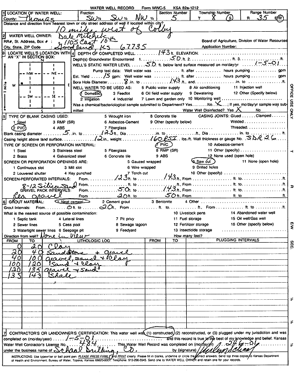
Mitchek, Dale | 143 ft. | 50 ft. | Domestic | Constructed | 05-Jan-2001 | Scan | ||
|
T8S, R35W, Sec. 5 SE NW SE |
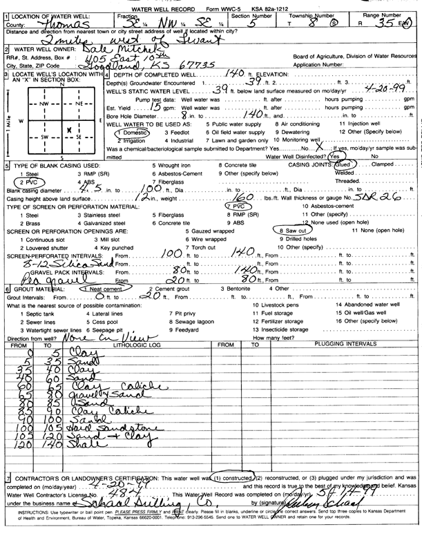
Mitchek, Dale | 140 ft. | 39 ft. | Domestic | Constructed | 20-Apr-1999 | Scan | ||
|
T8S, R35W, Sec. 6 SE SE NW |
ARP | 58 ft. | Monitoring well/observation/piezometer | 6 | Constructed | 28-Feb-1995 | |||
| View page: < Prev || 31 || 32 || 33 || 34 || 35 || 36 || 37 || 38 || 39 || 40 || Next > | |||||||||