Select location of well to view details.
Click on column heading to sort.
|
|
|
County: Trego Select location of well to view details. Click on column heading to sort. |
|
|
|
| View page: < Prev || 11 || 12 || 13 || 14 || 15 || 16 || 17 || 18 || 19 || 20 | |||||||||
| T-R-S | Owner | Well Depth Ascend. Desc. |
Static Water Level Ascend. Desc. |
Est. Yield Ascend. Desc. |
Well Use | Other ID | Action Taken | Completion Date Ascend. Desc. |
Scan? |
|
T14S, R21W, Sec. 31 SW NW NW |
Pierce, Steven | 39 ft. | 12 ft. | Test hole/well | Plugged | 08-Apr-2025 |
KOLAR |
||
|
T14S, R21W, Sec. 31 NW NE NW |
Pierce, Steven | 25 ft. | Other | Constructed | 14-May-2025 |
KOLAR |
|||
|
T14S, R21W, Sec. 31 SW NW NW |
Pierce, Steven | 29 ft. | 12 ft. | Test hole/well | Constructed | 08-Apr-2025 |
KOLAR |
||
|
T14S, R21W, Sec. 32 NW NW NW |
Eagle Communications | 48 ft. | 26 ft. | 25 gpm. | Feedlot | Constructed | 11-Oct-1994 | ||
|
T14S, R21W, Sec. 32 NE NE NE |
Nelson, Ron | 75 ft. | 23 ft. | 50 gpm. | Domestic | Constructed | 16-Dec-2013 | ||
|
T14S, R21W, Sec. 32 SE SE NE |
Schmidt, Robert | 64 ft. | 25 ft. | Domestic | Constructed | 03-Oct-1991 | |||
|
T14S, R21W, Sec. 33 NW NW NW |
Nelson, Ron | 43 ft. | 12 ft. | 30 gpm. | Domestic | Constructed | 03-Sep-2008 | ||
|
T14S, R21W, Sec. 33 NE SW NW |
Schmidt, Robert | 60 ft. | 10 ft. | Irrigation | Reconstructed | 22-Sep-2007 | |||
|
T14S, R21W, Sec. 33 NE SE SW NE |
Walter Kenneth Waters Jr Family Limited Trust | 60 ft. | 20 ft. | 20 gpm. | Domestic, Livestock | Constructed | 22-Nov-2016 |
KOLAR |
|
|
T14S, R21W, Sec. 33 SE SW SE NE |
Walter Kenneth Waters Jr. Family Limited | 60 ft. | 20 ft. | 40 gpm. | Domestic, Livestock | Constructed | 25-Jan-2017 |
KOLAR |
|
|
T14S, R21W, Sec. 34 SW SE NE NW |
Halligan, Troy | 60 ft. | 18 ft. | 30 gpm. | Domestic, Livestock | Constructed | 21-Sep-2015 |
KOLAR |
|
|
T14S, R21W, Sec. 35 SW SW SW |
Holtzinger, C.H. | 68 ft. | 48 ft. | 25 gpm. | Domestic | Constructed | 02-Nov-1984 | ||
|
T14S, R21W, Sec. 35 NE NW SW |
Waters, Irene | 23 ft. | 9 ft. | Domestic | Plugged | 27-Sep-1997 | |||
|
T14S, R21W, Sec. 36 SE SW SW |
Milberger, Wes | 28 ft. | 18 ft. | 20 gpm. | Domestic | Constructed | 24-Jun-1986 | ||
|
T14S, R22W, Sec. 3 NE NE NE |
Fabrizius, Mark | 26 ft. | 15 ft. | 20 gpm. | Domestic | Constructed | 17-Jul-1985 | ||
|
T14S, R22W, Sec. 10 NE NE SW |
Flox, Albert | 75 ft. | 60 ft. | 5 gpm. | Domestic | Constructed | 27-May-1993 | ||
|
T14S, R22W, Sec. 12 NE NW SE |
Weber, John | 62 ft. | 40 ft. | 3 gpm. | Domestic, Livestock | Constructed | 31-Mar-1978 | ||
|
T14S, R22W, Sec. 13 NW NE NE |
Zahn, Kendal | 600 ft. | 275 ft. | 10 gpm. | Domestic | Constructed | 05-Jan-1990 | ||
|
T14S, R22W, Sec. 18 NW NW NE |
Ries, Dwayne | 59 ft. | 13 ft. | 15 gpm. | Domestic | Constructed | 09-Apr-1990 | ||
|
T14S, R22W, Sec. 22 SW NE NW |
Spines Exploration/Rudy Bollig | 630 ft. | 200 ft. | Oil Field Water Supply | Constructed | 18-Feb-1984 | |||
|
T14S, R22W, Sec. 24 NE NE NE |
Weber, John | 27 ft. | 17 ft. | 14 gpm. | Domestic, Livestock | Constructed | 27-Mar-1978 | ||
|
T14S, R22W, Sec. 26 SW NE NE |
Cedar Bluff State Park | 90 ft. | 41 ft. | Public Water Supply | Plugged | 02-Nov-2002 | Scan | ||
|
T14S, R22W, Sec. 26 C E2 |
Cedar Bluff State Park | 102 ft. | 32 ft. | Public Water Supply | Plugged | 02-Nov-2002 | Scan | ||
|
T14S, R22W, Sec. 26 SW SE NW |
Cedar Bluff State Park | 110 ft. | 50 ft. | 100 gpm. | Public Water Supply | Constructed | 06-Dec-1978 | ||
|
T14S, R22W, Sec. 26 SE SE NW |
Cedar Bluff State Park | 110 ft. | 50 ft. | 100 gpm. | Public Water Supply | Constructed | 06-Dec-1978 | ||
|
T14S, R22W, Sec. 26 SE SE NW |
Kansas Dept. of Wildlife and Parks | 52 ft. | 37 ft. | Domestic | Plugged | 18-Sep-1996 | |||
|
T14S, R22W, Sec. 26 NW NW NE |
U.S. Bureau of Reclamation | 100 ft. | 55 ft. | 20 gpm. | Domestic | Constructed | 01-Sep-1983 | ||
|
T14S, R22W, Sec. 30 NW SW SE |
Schoenthaler, Terry | 93 ft. | 62 ft. | 20 gpm. | Feedlot | Constructed | 11-May-1982 | ||
|
T14S, R22W, Sec. 31 NW NE NE |
Circle S Ranch/Bob Schmidt | 38 ft. | 12 ft. | Domestic | Constructed | 04-Apr-1990 | |||
|
T14S, R22W, Sec. 33 SW NW NE |
Cedar Bluff Cabin Area | 500 ft. | Public Water Supply | Constructed | 30-Aug-1977 | ||||
|
T14S, R22W, Sec. 33 NW NE NE |
Cedar Bluff Christian Camp | 521 ft. | 180 ft. | 30 gpm. | Domestic | Constructed | 23-Jun-1995 | ||
|
T14S, R22W, Sec. 33 NW NE NE |
Cedar Bluff Christian Camp | 626 ft. | (unstated)/abandoned | Plugged | 11-Sep-2008 | ||||
|
T14S, R22W, Sec. 33 NE NE NE |
Cedar Bluff Christian Camp | 470 ft. | 450 ft. | 5 gpm. | Irrigation | Constructed | 28-Oct-1977 | ||
|
T14S, R22W, Sec. 33 NW NE NE |
Cedar Bluff Christian Camp | 520 ft. | Domestic | Plugged | 23-Jun-1995 | ||||
|
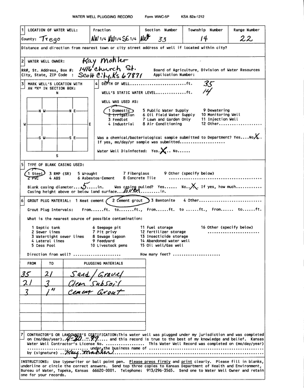
T14S, R22W, Sec. 33 NW NW SE |
Mohler, Kay | 35 ft. | 14 ft. | Domestic | Plugged | 30-Apr-1999 | Scan | ||
|
T14S, R22W, Sec. 33 SE NE NW |
North Shore Cabin Area | 590 ft. | 165 ft. | Public Water Supply | Plugged | 23-Apr-2012 | |||
|
T14S, R22W, Sec. 33 SE NE NW |
North Shore Cabin Area | 550 ft. | 165 ft. | Public Water Supply | Plugged | 23-Apr-2012 | |||
|
T14S, R22W, Sec. 33 NW SE NW |
North Shore Cabin Assoc./Walter Krause | 480 ft. | 205 ft. | Public Water Supply | Constructed | 31-Aug-1985 | |||
|
T14S, R22W, Sec. 36 NW SE SE |
Cedar Bluff National Fish Hatchery | 560 ft. | 260 ft. | 10 gpm. | Domestic | Constructed | 16-Jul-1979 | ||
|
T14S, R23W, Sec. 2 SE NE SE SE |
Schneider, Dennis | 43 ft. | 15 ft. | 2 gpm. | Domestic, Livestock | Constructed | 03-Jul-2013 |
KOLAR |
|
|
T14S, R23W, Sec. 4 NW NW SE |
Schoenberger, Kenneth | 28 ft. | 20 ft. | 5 gpm. | Domestic | Constructed | 08-Jun-1981 | ||
|
T14S, R23W, Sec. 6 NW SW NE SW |
Linden, Kay | 11.6 ft. | 4 ft. | Domestic | Well 1 | Plugged | 18-Jun-2020 | ||
|
T14S, R23W, Sec. 6 NW SW NE SW |
Linden, Kay | 10.16 ft. | 3 ft. | Domestic | Well 2 | Plugged | 18-Jun-2020 | ||
|
T14S, R23W, Sec. 6 NW SW NE SW |
Linden, Kay | 6.83 ft. | 1 ft. | Domestic | Well 4 | Plugged | 18-Jun-2020 | ||
|
T14S, R23W, Sec. 6 NW SW NE SW |
Linden, Kay | 21.16 ft. | 4 ft. | Domestic | Well 3 | Plugged | 18-Jun-2020 | ||
|
T14S, R23W, Sec. 9 NW NW NE |
Kreutzer, Tom | 35 ft. | 13 ft. | 15 gpm. | Domestic, Livestock | Constructed | 07-Jul-2023 |
KOLAR |
|
|
T14S, R23W, Sec. 11 SW SE SE |
Cook, W.D. | 25 ft. | 1 ft. | 2 gpm. | Domestic | Constructed | 10-May-1988 | ||
|
T14S, R23W, Sec. 22 NE NW SE |
Ferbridges, Carroll | 45 ft. | Domestic | Plugged | 01-Aug-1978 | ||||
|
T14S, R23W, Sec. 22 SE NW SE |
Ferbridges, Carroll | 22 ft. | Domestic | Plugged | 01-Aug-1978 | ||||
|
T14S, R23W, Sec. 22 C NW SE |
Schneider, Scott | 30 ft. | 15 ft. | 12 gpm. | Domestic | Constructed | 10-Jul-1991 | ||
| View page: < Prev || 11 || 12 || 13 || 14 || 15 || 16 || 17 || 18 || 19 || 20 | |||||||||