Select location of well to view details.
Click on column heading to sort.
|
|
|
County: Wilson Select location of well to view details. Click on column heading to sort. |
|
|
|
| View page: 1 || 2 || 3 || 4 || 5 || 6 || 7 || 8 || 9 || 10 || Next > | |||||||||
| T-R-S | Owner | Well Depth Ascend. Desc. |
Static Water Level Ascend. Desc. |
Est. Yield Ascend. Desc. |
Well Use | Other ID | Action Taken | Completion Date Ascend. Desc. |
Scan? |
|
T29S, R14E, Sec. 12 SW SW SW |
Halls Food Mart | 15 ft. | 8.6 ft. | Monitoring well/observation/piezometer | MW 2 | Constructed | 07-Jan-2009 | ||
|
T29S, R14E, Sec. 12 SW SW SW |
Halls Food Mart | 14.83 ft. | Monitoring well/observation/piezometer | MW 2 | Plugged | 26-Feb-2010 | |||
|
T29S, R14E, Sec. 12 SW SW SW |
Halls Food Mart | 14.41 ft. | Monitoring well/observation/piezometer | MW 1 | Plugged | 26-Feb-2010 | |||
|
T29S, R14E, Sec. 12 SW SW SW |
Halls Food Mart | 14.63 ft. | Monitoring well/observation/piezometer | EMW 4 | Plugged | 26-Feb-2010 | |||
|
T29S, R14E, Sec. 12 SW SW SW |
Halls Food Mart | 13.72 ft. | Monitoring well/observation/piezometer | EMW 2 | Plugged | 26-Feb-2010 | |||
|
T29S, R14E, Sec. 12 SW SW SW |
Halls Food Mart | 18.9 ft. | Monitoring well/observation/piezometer | EMW 1 | Plugged | 26-Feb-2010 | |||
|
T29S, R14E, Sec. 12 SW NW SW NW |
KDHE (Pete's #50) | 20 ft. | 2.7 ft. | Monitoring well/observation/piezometer | MW 13 | Constructed | 05-Apr-2023 | ||
|
T29S, R14E, Sec. 13 NW NW NW |
Halls Food Mart | 15 ft. | 13.8 ft. | Monitoring well/observation/piezometer | MW 3 | Constructed | 07-Jan-2009 | ||
|
T29S, R14E, Sec. 13 NW NW NW |
Halls Food Mart | 18 ft. | 3.81 ft. | Monitoring well/observation/piezometer | MW 5 | Constructed | 28-Jul-2009 | ||
|
T29S, R14E, Sec. 13 NW NW NW |
Halls Food Mart | 14.45 ft. | Monitoring well/observation/piezometer | MW 3 | Plugged | 26-Feb-2010 | |||
|
T29S, R14E, Sec. 13 NW NW NW |
Halls Food Mart | 17.8 ft. | Monitoring well/observation/piezometer | MW 5 | Plugged | 26-Feb-2010 | |||
|
T29S, R14E, Sec. 13 NW NW NW |
Halls Food Mart | 14.77 ft. | Monitoring well/observation/piezometer | MW 4 | Plugged | 26-Feb-2010 | |||
|
T29S, R14E, Sec. 13 NW NW NW |
Halls Food Mart | 15 ft. | 10.25 ft. | Monitoring well/observation/piezometer | MW 4 | Constructed | 27-Jul-2009 | ||
|
T29S, R14E, Sec. 14 NE NE NE |
Halls Food Mart | 14.78 ft. | Monitoring well/observation/piezometer | MW 7 | Plugged | 26-Feb-2010 | |||
|
T29S, R14E, Sec. 14 NE NE NE |
Halls Food Mart | 14.78 ft. | Monitoring well/observation/piezometer | MW 6 | Plugged | 26-Feb-2010 | |||
|
T29S, R14E, Sec. 14 NE NE NE |
Halls Food Mart | 15 ft. | 3.33 ft. | Monitoring well/observation/piezometer | MW 7 | Constructed | 28-Jul-2009 | ||
|
T29S, R14E, Sec. 14 NE NE NE |
Halls Food Mart | 15 ft. | 6.21 ft. | Monitoring well/observation/piezometer | MW 6 | Constructed | 28-Jul-2009 | ||
|
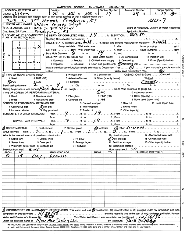
T29S, R14E, Sec. 14 SE NE NE |
Wilson County Shop | 19 ft. | 2.18 ft. | Monitoring well/observation/piezometer | MW 7 | Constructed | 20-Nov-1998 | Scan | |
|
T29S, R14E, Sec. 14 SE NE NE |
Wilson County Shop | 12.3 ft. | Monitoring well/observation/piezometer | MW 8 | Plugged | 24-Feb-2014 | |||
|
T29S, R14E, Sec. 14 SE NE NE |
Wilson County Shop | 13 ft. | Monitoring well/observation/piezometer | MW 6 R | Constructed | 09-May-2008 | |||
|
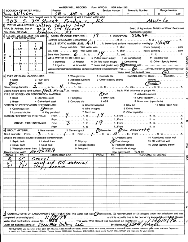
T29S, R14E, Sec. 14 SE NE NE |
Wilson County Shop | 19 ft. | 4.11 ft. | Monitoring well/observation/piezometer | MW 6 | Constructed | 19-Nov-1998 | Scan | |
|
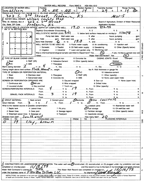
T29S, R14E, Sec. 14 SE NE NE |
Wilson County Shop | 19 ft. | 3.51 ft. | Monitoring well/observation/piezometer | MW 5 | Constructed | 19-Nov-1998 | Scan | |
|
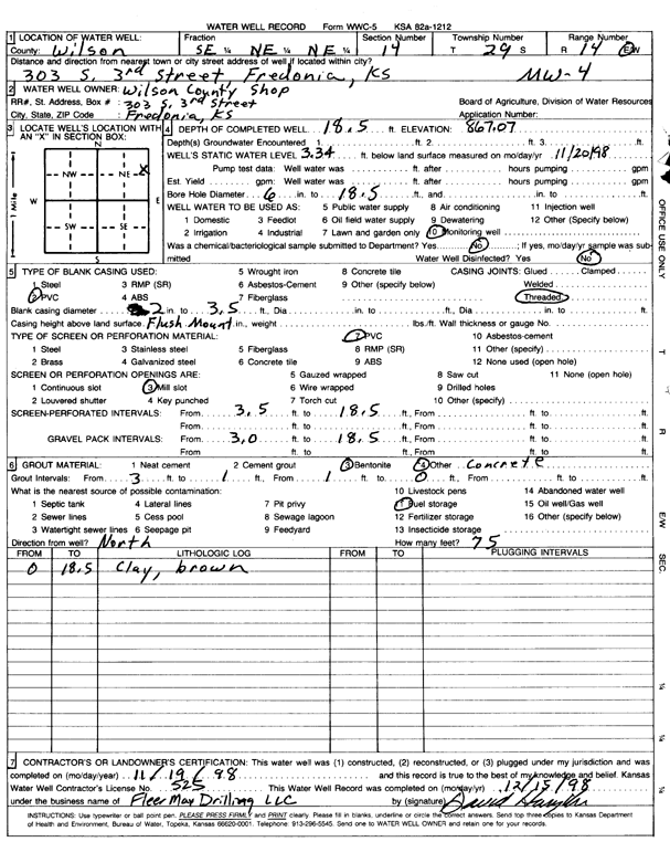
T29S, R14E, Sec. 14 SE NE NE |
Wilson County Shop | 18.5 ft. | 3.34 ft. | Monitoring well/observation/piezometer | MW 4 | Constructed | 19-Nov-1998 | Scan | |
|
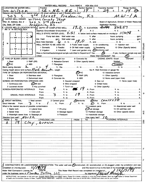
T29S, R14E, Sec. 14 SE NE NE |
Wilson County Shop | 19 ft. | 2.51 ft. | Monitoring well/observation/piezometer | MW 1A | Constructed | 19-Nov-1998 | Scan | |
|
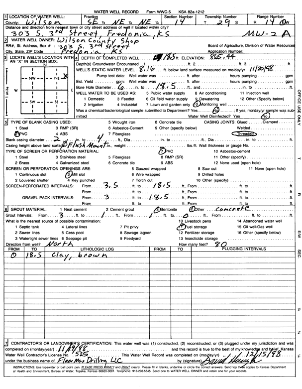
T29S, R14E, Sec. 14 SE NE NE |
Wilson County Shop | 18.5 ft. | 8.16 ft. | Monitoring well/observation/piezometer | MW 2A | Constructed | 19-Nov-1998 | Scan | |
|
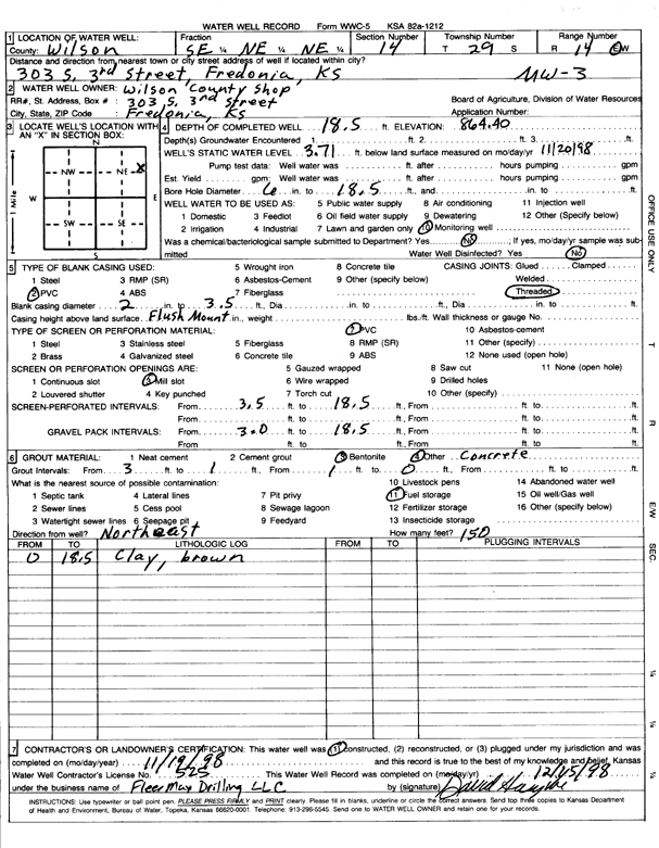
T29S, R14E, Sec. 14 SE NE NE |
Wilson County Shop | 18.5 ft. | 3.71 ft. | Monitoring well/observation/piezometer | MW 3 | Constructed | 19-Nov-1998 | Scan | |
|
T29S, R14E, Sec. 14 SE NE NE |
Wilson County Shop | 15.1 ft. | Monitoring well/observation/piezometer | MW 7 | Plugged | 24-Feb-2014 | |||
|
T29S, R14E, Sec. 14 SE NE NE |
Wilson County Shop | 10.6 ft. | Monitoring well/observation/piezometer | MW 6 R | Plugged | 24-Feb-2014 | |||
|
T29S, R14E, Sec. 14 SE NE NE |
Wilson County Shop | 18.25 ft. | Monitoring well/observation/piezometer | MW 5 | Plugged | 24-Feb-2014 | |||
|
T29S, R14E, Sec. 14 SE NE NE |
Wilson County Shop | 18.8 ft. | Monitoring well/observation/piezometer | MW 4 | Plugged | 24-Feb-2014 | |||
|
T29S, R14E, Sec. 14 SE NE NE |
Wilson County Shop | 17.3 ft. | Monitoring well/observation/piezometer | MW 3 | Plugged | 24-Feb-2014 | |||
|
T29S, R14E, Sec. 14 SE NE NE |
Wilson County Shop | 13.3 ft. | Monitoring well/observation/piezometer | MW 2 R | Plugged | 24-Feb-2014 | |||
|
T29S, R14E, Sec. 14 SE NE NE |
Wilson County Shop | 15.6 ft. | Monitoring well/observation/piezometer | MW 1 | Plugged | 24-Feb-2014 | |||
|
T29S, R14E, Sec. 14 SE NE NE |
Wilson County Shop | 12.3 ft. | 2.38 ft. | Monitoring well/observation/piezometer | MW 8 | Constructed | 22-Aug-2013 | ||
|
T29S, R14E, Sec. 14 SE NE NE |
Wilson County Shop | 13 ft. | Monitoring well/observation/piezometer | MW 2 R | Constructed | 09-May-2008 | |||
|
T29S, R14E, Sec. 20 NE SE SE |
Boyer, Ronald | 82 ft. | 16 ft. | 2 gpm. | Domestic | Constructed | 27-Mar-1979 | ||
|
T29S, R14E, Sec. 24 SE SW NW |
Fredonia Golf Club | 80 ft. | 25 ft. | Irrigation | Constructed | 06-Aug-1994 | |||
|
T29S, R14E, Sec. 24 NW SW NE |
Lafarge | 19.67 ft. | Monitoring well/observation/piezometer | MW 6 | Constructed | 25-Feb-2006 | |||
|
T29S, R14E, Sec. 24 SE NW SE |
Lafarge | 20 ft. | 11.5 ft. | Monitoring well/observation/piezometer | MW 1 | Constructed | 09-Feb-1996 | ||
|
T29S, R14E, Sec. 24 NW SW NE |
Lafarge | 35 ft. | 35.11 ft. | Monitoring well/observation/piezometer | PZ 12 | Constructed | 29-Aug-2007 | ||
|
T29S, R14E, Sec. 24 NW SW NE |
Lafarge | 40 ft. | Monitoring well/observation/piezometer | MW 13 | Constructed | 30-Aug-2007 | |||
|
T29S, R14E, Sec. 24 NW SW NE |
Lafarge | 27.25 ft. | 18.5 ft. | Monitoring well/observation/piezometer | PZ 14 | Constructed | 27-Feb-2006 | ||
|
T29S, R14E, Sec. 24 NW SW NE |
Lafarge | 20 ft. | Monitoring well/observation/piezometer | MW 5 | Constructed | 26-Feb-2006 | |||
|
T29S, R14E, Sec. 24 NW SW NE |
Lafarge | 46.1 ft. | Monitoring well/observation/piezometer | PZ 19 | Constructed | 17-Aug-2007 | |||
|
T29S, R14E, Sec. 24 NW SW NE |
Lafarge | 55.5 ft. | Monitoring well/observation/piezometer | PZ 15 | Constructed | 17-Aug-2007 | |||
|
T29S, R14E, Sec. 24 NW SW NE |
Lafarge | 40.42 ft. | Monitoring well/observation/piezometer | PZ 18 | Constructed | 15-Aug-2007 | |||
|
T29S, R14E, Sec. 24 NW SW NE |
Lafarge | 25.2 ft. | Monitoring well/observation/piezometer | MW 10 | Constructed | 29-Jun-2007 | |||
|
T29S, R14E, Sec. 24 NW SW NE |
Lafarge | 64.6 ft. | Monitoring well/observation/piezometer | MW 14 | Constructed | 28-Aug-2007 | |||
|
T29S, R14E, Sec. 24 NW SE NE |
Lafarge | 15 ft. | 8 ft. | Monitoring well/observation/piezometer | MW 2 | Constructed | 09-Feb-1996 | ||
|
T29S, R14E, Sec. 24 NW SW NE |
Lafarge | 17 ft. | Monitoring well/observation/piezometer | MW 4 | Constructed | 26-Feb-2006 | |||
| View page: 1 || 2 || 3 || 4 || 5 || 6 || 7 || 8 || 9 || 10 || Next > | |||||||||