Select location of well to view details.
Click on column heading to sort.
|
|
|
County: Wyandotte Select location of well to view details. Click on column heading to sort. |
|
|
|
| View page: < Prev || 31 || 32 || 33 || 34 || 35 || 36 || 37 || 38 || 39 || 40 || Next > | |||||||||
| T-R-S | Owner | Well Depth Ascend. Desc. |
Static Water Level Ascend. Desc. |
Est. Yield Ascend. Desc. |
Well Use | Other ID | Action Taken | Completion Date Ascend. Desc. |
Scan? |
|
T10S, R25E, Sec. 34 SE SW NE |
General Motors Corp. | 35 ft. | Monitoring well/observation/piezometer | MW 6a | Constructed | 18-Apr-1985 | |||
|
T10S, R25E, Sec. 34 NE NW SE |
Highway Carrier | 25 ft. | 14.55 ft. | Monitoring well/observation/piezometer | MW 1 | Constructed | 11-Sep-1998 | ||
|
T10S, R25E, Sec. 34 NE NW SE |
Highway Carrier | 25 ft. | 13.6 ft. | Monitoring well/observation/piezometer | MW 3 | Constructed | 11-Sep-1998 | ||
|
T10S, R25E, Sec. 34 NE NW SE |
Highway Carrier | 20 ft. | 11.75 ft. | Monitoring well/observation/piezometer | MW 6 | Constructed | 11-Sep-1998 | ||
|
T10S, R25E, Sec. 34 NE NW SE |
Highway Carriers | 25 ft. | 14.14 ft. | Monitoring well/observation/piezometer | MW 2 | Constructed | 11-Sep-1998 | ||
|
T10S, R25E, Sec. 34 SE SW NE |
Huhtamaki Inc. | 60 ft. | Monitoring well/observation/piezometer | MW 25 D | Constructed | 24-Jul-2007 | |||
|
T10S, R25E, Sec. 34 SE SW NE |
Huhtamaki Inc. | 30 ft. | Monitoring well/observation/piezometer | MW 25 S | Constructed | 25-Jul-2007 | |||
|
T10S, R25E, Sec. 34 SE SW NE |
Huhtamaki Inc. | 45 ft. | Monitoring well/observation/piezometer | MW 25 I | Constructed | 25-Jul-2007 | |||
|
T10S, R25E, Sec. 34 SE SW NE |
Huhtamaki Inc. | 60 ft. | Monitoring well/observation/piezometer | MW 26 D | Constructed | 18-Sep-2007 | |||
|
T10S, R25E, Sec. 34 SE SW NE |
Huhtamaki Inc. | 45 ft. | Monitoring well/observation/piezometer | MW 27 I | Constructed | 26-Jul-2007 | |||
|
T10S, R25E, Sec. 34 SE SW NE |
Huhtamaki Inc. | 30 ft. | Monitoring well/observation/piezometer | MW 26 S | Constructed | 19-Sep-2007 | |||
|
T10S, R25E, Sec. 34 S2 SE NE |
Huhtamaki Inc. | 28.71 ft. | 18.9 ft. | Monitoring well/observation/piezometer | MW 26 S | Plugged | 08-Nov-2013 | ||
|
T10S, R25E, Sec. 34 SE SW NE |
Huhtamaki Inc. | 60 ft. | 22.2 ft. | Monitoring well/observation/piezometer | MW 25 D | Plugged | 14-Jul-2014 | ||
|
T10S, R25E, Sec. 34 SE SW NE |
Huhtamaki Inc. | 45 ft. | 22.4 ft. | Monitoring well/observation/piezometer | MW 25 I | Plugged | 14-Jul-2014 | ||
|
T10S, R25E, Sec. 34 NE SW NE |
Huhtamaki Inc. | 44.32 ft. | 17.81 ft. | Monitoring well/observation/piezometer | MW 015 | Plugged | 17-Apr-2012 | ||
|
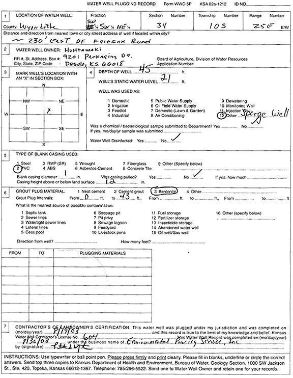
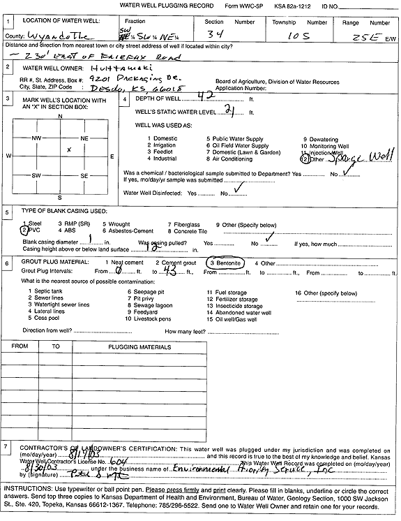
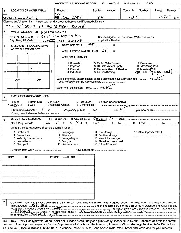
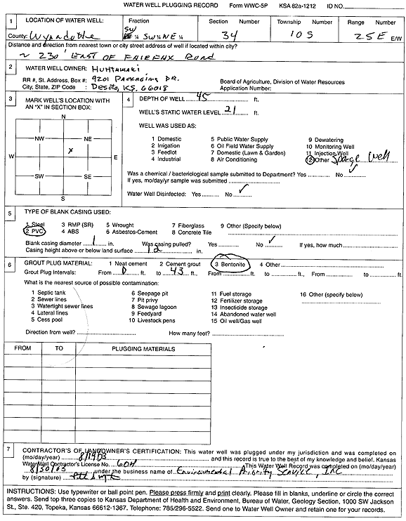
T10S, R25E, Sec. 34 SW SW NE |
Huhtamaki Inc. | 45 ft. | 21 ft. | Environmental Remediation, Air Sparge | Plugged | 19-Aug-2003 | Scan | ||
|
T10S, R25E, Sec. 34 NE SW NE |
Huhtamaki Inc. | 84.55 ft. | 18.11 ft. | Monitoring well/observation/piezometer | MW 20 | Plugged | 17-Apr-2012 | ||
|
T10S, R25E, Sec. 34 NE SW NE |
Huhtamaki Inc. | 83.1 ft. | 18.04 ft. | Monitoring well/observation/piezometer | MW 7 | Plugged | 17-Apr-2012 | ||
|
T10S, R25E, Sec. 34 NE SW NE |
Huhtamaki Inc. | 55.75 ft. | 18.13 ft. | Monitoring well/observation/piezometer | MW 006 | Plugged | 17-Apr-2012 | ||
|
T10S, R25E, Sec. 34 NE SW NE |
Huhtamaki Inc. | 30.22 ft. | 18.03 ft. | Monitoring well/observation/piezometer | MW 005 B | Plugged | 17-Apr-2012 | ||
|
T10S, R25E, Sec. 34 SE SW NE |
Huhtamaki Inc. | 60 ft. | Monitoring well/observation/piezometer | MW 27 D | Constructed | 25-Jul-2007 | |||
|
T10S, R25E, Sec. 34 SW NE SE NE |
Huhtamaki Inc. | 74 ft. | 18.03 ft. | Monitoring well/observation/piezometer | MW 31D | Constructed | 12-Jul-2016 |
KOLAR |
|
|
T10S, R25E, Sec. 34 SE SW SE NE |
Huhtamaki Inc. | 85.1 ft. | 15.5 ft. | Monitoring well/observation/piezometer | MW 016 | Plugged | 23-Sep-2016 |
KOLAR |
|
|
T10S, R25E, Sec. 34 NW SE SW NE |
Huhtamaki Inc. | 45.12 ft. | 14.7 ft. | Monitoring well/observation/piezometer | MW 013 | Plugged | 23-Sep-2016 |
KOLAR |
|
|
T10S, R25E, Sec. 34 SE SW NE |
Huhtamaki Inc. | 30 ft. | 22.5 ft. | Monitoring well/observation/piezometer | MW 25 S | Plugged | 14-Jul-2014 | ||
|
T10S, R25E, Sec. 34 SE SW NE |
Huhtamaki Inc. | 60 ft. | 19.9 ft. | Monitoring well/observation/piezometer | MW 26 D | Plugged | 14-Jul-2014 | ||
|
T10S, R25E, Sec. 34 SE SW NE |
Huhtamaki Inc. | 45 ft. | 20.1 ft. | Monitoring well/observation/piezometer | MW 26 I | Plugged | 14-Jul-2014 | ||
|
T10S, R25E, Sec. 34 S2 SE NE |
Huhtamaki Inc. | 64.05 ft. | 16.42 ft. | Monitoring well/observation/piezometer | MW 29 D | Constructed | 18-Nov-2014 | ||
|
T10S, R25E, Sec. 34 S2 SE NE |
Huhtamaki Inc. | 48.53 ft. | 16.51 ft. | Monitoring well/observation/piezometer | MW 29 I | Constructed | 18-Nov-2014 | ||
|
T10S, R25E, Sec. 34 SE SW SE NE |
Huhtamaki Inc. | 58.5 ft. | 20 ft. | Monitoring well/observation/piezometer | MW 26 DR | Constructed | 08-Dec-2014 |
KOLAR |
|
|
T10S, R25E, Sec. 34 NW SE SW NE |
Huhtamaki Inc. | 61.8 ft. | 20 ft. | Monitoring well/observation/piezometer | MW 23R | Constructed | 04-Nov-2014 |
KOLAR |
|
|
T10S, R25E, Sec. 34 SE SE SW NE |
Huhtamaki Inc. | 44.6 ft. | 20 ft. | Monitoring well/observation/piezometer | MW 25IR | Constructed | 09-Dec-2014 |
KOLAR |
|
|
T10S, R25E, Sec. 34 NE SW NE |
Huhtamaki Inc. | 31.18 ft. | 18.41 ft. | Monitoring well/observation/piezometer | MW 14 | Plugged | 17-Apr-2012 | ||
|
T10S, R25E, Sec. 34 NE SW NE |
Huhtamaki Inc. | 38 ft. | 20.36 ft. | Monitoring well/observation/piezometer | MW 28 | Constructed | 14-Nov-2012 | ||
|
T10S, R25E, Sec. 34 SE SW NE |
Huhtamaki Inc. | 25.62 ft. | Monitoring well/observation/piezometer | MW 25 IR | Plugged | 27-Feb-2008 | |||
|
T10S, R25E, Sec. 34 SW SE SW NE |
Huhtamaki Inc. | 29.2 ft. | 20 ft. | Monitoring well/observation/piezometer | MW 10R | Constructed | 04-Nov-2014 |
KOLAR |
|
|
T10S, R25E, Sec. 34 NW SE SW NE |
Huhtamaki Inc. | 27 ft. | 20 ft. | Monitoring well/observation/piezometer | MW 21R | Constructed | 04-Nov-2014 |
KOLAR |
|
|
T10S, R25E, Sec. 34 NW SE SW NE |
Huhtamaki Inc. | 42.7 ft. | 20 ft. | Monitoring well/observation/piezometer | MW 22R | Constructed | 04-Nov-2014 |
KOLAR |
|
|
T10S, R25E, Sec. 34 S2 SE NE |
Huhtamaki Inc. | 60.23 ft. | 19.83 ft. | Monitoring well/observation/piezometer | MW 30 D | Constructed | 19-Nov-2014 | ||
|
T10S, R25E, Sec. 34 SE SW NE |
Huhtamaki Inc. | 43.5 ft. | 22.3 ft. | Monitoring well/observation/piezometer | MW 25 I | Plugged | 27-Feb-2008 | ||
|
T10S, R25E, Sec. 34 S2 SE NE |
Huhtamaki Inc. | 50.3 ft. | 19.48 ft. | Monitoring well/observation/piezometer | MW 30 I | Constructed | 19-Nov-2014 | ||
|
T10S, R25E, Sec. 34 SE SW NE |
Huhtamaki Inc. | 45 ft. | Monitoring well/observation/piezometer | MW 26 I | Constructed | 26-Jul-2007 | |||
|
T10S, R25E, Sec. 34 SW SW NE |
Huhtamaki Inc. | 42 ft. | 21 ft. | Environmental Remediation, Air Sparge | Plugged | 19-Aug-2003 | Scan | ||
|
T10S, R25E, Sec. 34 SE SW NE |
Huhtamaki Inc. | 30 ft. | Monitoring well/observation/piezometer | MW 27 S | Constructed | 26-Jul-2007 | |||
|
T10S, R25E, Sec. 34 SW SW NE |
Huhtamaki Inc. | 45 ft. | 21 ft. | Environmental Remediation, Air Sparge | Plugged | 19-Aug-2003 | Scan | ||
|
T10S, R25E, Sec. 34 SW SW NE |
Huhtamaki Inc. | 45 ft. | 21 ft. | Environmental Remediation, Air Sparge | Plugged | 19-Aug-2003 | Scan | ||
|
T10S, R25E, Sec. 34 SW SW NE |
INX International Ink Co | 20 ft. | 16.5 ft. | Monitoring well/observation/piezometer | INX 5 | Plugged | 04-Sep-2018 | ||
|
T10S, R25E, Sec. 34 SW SW NE |
INX International Ink Co | 46.81 ft. | 17 ft. | Monitoring well/observation/piezometer | INX 2 | Plugged | 04-Sep-2018 | ||
|
T10S, R25E, Sec. 34 SW SW NE |
INX International Ink Co | 29.3 ft. | 18.05 ft. | Monitoring well/observation/piezometer | INX 13 | Plugged | 30-Aug-2021 | ||
|
T10S, R25E, Sec. 34 SW SW NE |
INX International Ink Co | 29.1 ft. | 18.85 ft. | Monitoring well/observation/piezometer | INX 17 | Plugged | 30-Aug-2021 | ||
| View page: < Prev || 31 || 32 || 33 || 34 || 35 || 36 || 37 || 38 || 39 || 40 || Next > | |||||||||