Select location of well to view details.
Click on column heading to sort.
|
|
|
County: Clark Select location of well to view details. Click on column heading to sort. |
|
|
|
| View page: < Prev || 11 || 12 || 13 || 14 || 15 || 16 || 17 || 18 || 19 || 20 || Next > | |||||||||
| T-R-S | Owner | Well Depth Ascend. Desc. |
Static Water Level Ascend. Desc. |
Est. Yield Ascend. Desc. |
Well Use | Other ID | Action Taken | Completion Date Ascend. Desc. |
Scan? |
|
T33S, R23W, Sec. 10 NW NW NW |
Gardiner, Garth | 145 ft. | 53 ft. | 20 gpm. | Domestic | Constructed | 13-Jul-2016 | ||
|
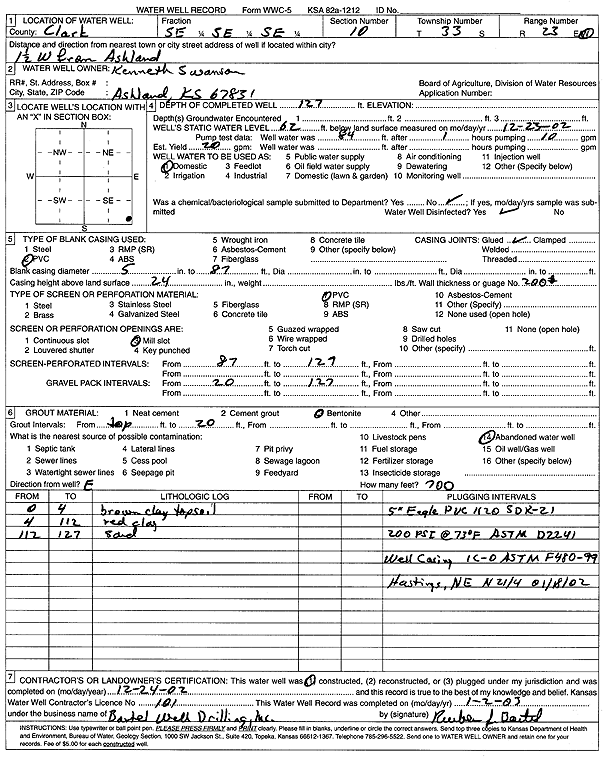
T33S, R23W, Sec. 10 SE SE SE |
Swanson, Kenneth | 127 ft. | 62 ft. | 20 gpm. | Domestic | Constructed | 24-Dec-2002 | Scan | |
|
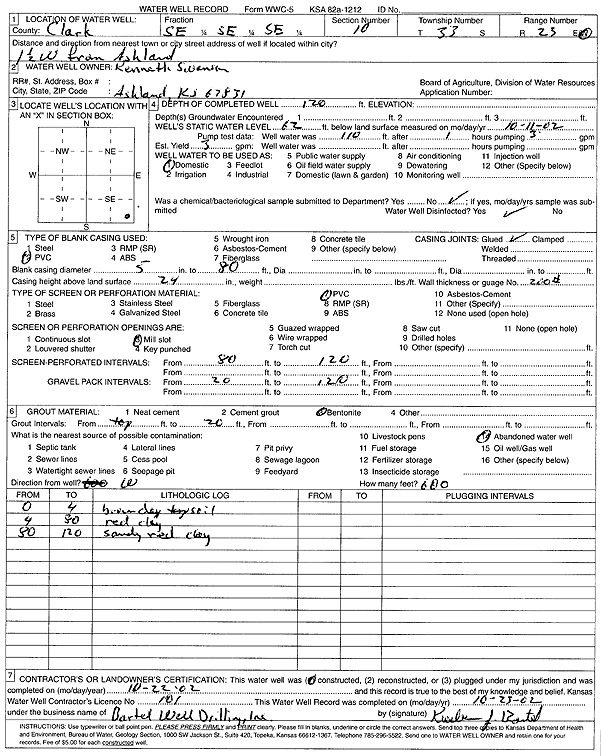
T33S, R23W, Sec. 10 SE SE SE |
Swanson, Kenneth | 120 ft. | 62 ft. | 3 gpm. | Domestic | Constructed | 22-Oct-2002 | Scan | |
|
T33S, R23W, Sec. 11 NW NE NW |
Bisel, Jim | 144 ft. | 65 ft. | 5.5 gpm. | Domestic | Constructed | 03-Jun-1994 | ||
|
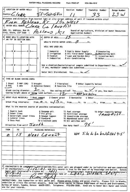
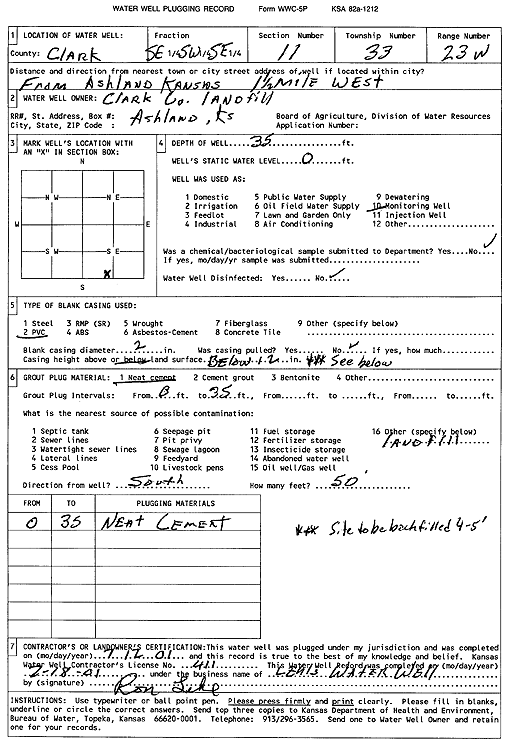
T33S, R23W, Sec. 11 SE SW SE |
Clark County Landfill | 15 ft. | Monitoring well/observation/piezometer | Plugged | 12-Jul-2001 | Scan | |||
|
T33S, R23W, Sec. 11 SW SW SE |
Clark County Landfill | 91 ft. | Monitoring well/observation/piezometer | Constructed | 24-May-1993 | ||||
|
T33S, R23W, Sec. 11 S2 SW SE |
Clark County Landfill | 66 ft. | 32.92 ft. | Monitoring well/observation/piezometer | OW 5 | Constructed | 28-Dec-1993 | ||
|
T33S, R23W, Sec. 11 NE SW SE |
Clark County Landfill | 77 ft. | Monitoring well/observation/piezometer | MW 9 | Constructed | 23-Aug-2012 | |||
|
T33S, R23W, Sec. 11 SW SW SE |
Clark County Landfill | 16.5 ft. | Monitoring well/observation/piezometer | MW 3-93 | Constructed | 24-May-1993 | |||
|
T33S, R23W, Sec. 11 S2 SW SE |
Clark County Landfill | 90 ft. | 77.16 ft. | Monitoring well/observation/piezometer | OW 4 | Constructed | 28-Dec-1993 | ||
|
T33S, R23W, Sec. 11 S2 SW SE |
Clark County Landfill | 91 ft. | 77.23 ft. | Monitoring well/observation/piezometer | OW 2 | Constructed | 28-Dec-1993 | ||
|
T33S, R23W, Sec. 11 SW SW SE |
Clark County Landfill | 114 ft. | 67 ft. | 40 gpm. | Domestic | Constructed | 09-Oct-2009 | ||
|
T33S, R23W, Sec. 11 SW SW SE |
Clark County Landfill | 101.5 ft. | 67.12 ft. | Monitoring well/observation/piezometer | MW 8 | Plugged | 07-Apr-2011 | ||
|
T33S, R23W, Sec. 11 SE SW SE |
Clark County Landfill | 35 ft. | Monitoring well/observation/piezometer | Plugged | 12-Jul-2001 | Scan | |||
|
T33S, R23W, Sec. 11 SW SW SE |
Clark County Landfill | 30 ft. | Monitoring well/observation/piezometer | MW 1-93 | Constructed | 24-May-1993 | |||
|
T33S, R23W, Sec. 11 NE NE SW SE |
Geotechnical Services, Inc. | 77 ft. | 50 ft. | .5 gpm. | Monitoring well/observation/piezometer | MW 1 | Constructed | 23-Aug-2012 |
KOLAR |
|
T33S, R23W, Sec. 11 SW SW NW NW |
Seacat Farms | 154 ft. | 76 ft. | 5 gpm. | Domestic, Livestock | Constructed | 24-Oct-2018 |
KOLAR |
|
|
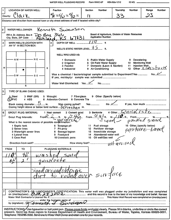
T33S, R23W, Sec. 11 NE SW SW |
Swanson, Kenneth | 119 ft. | 85 ft. | Domestic, Livestock | Plugged | 28-Oct-2002 | Scan | ||
|
T33S, R23W, Sec. 11 SE SE NW |
Swanson, Kenneth | 140 ft. | 60 ft. | 3 gpm. | Domestic | Constructed | 30-Nov-1994 | ||
|
T33S, R23W, Sec. 12 SW SW SE |
City of Ashland | 99 ft. | 36 ft. | Public Water Supply | Plugged | 05-Apr-2008 | |||
|
T33S, R23W, Sec. 12 SW SW SE |
City of Ashland | 93 ft. | 36 ft. | Monitoring well/observation/piezometer | Constructed | 15-Oct-2006 | |||
|
T33S, R23W, Sec. 12 SW SW SE |
City of Ashland | 99 ft. | 36 ft. | Monitoring well/observation/piezometer | Plugged | 05-Apr-2008 | |||
|
T33S, R23W, Sec. 12 SE SE NW |
City of Ashland | 84 ft. | 44 ft. | Public Water Supply | Plugged | 08-Oct-1997 | |||
|
T33S, R23W, Sec. 12 SW SW SE |
City of Ashland | 99 ft. | 33.5 ft. | Public Water Supply | Constructed | 31-Aug-2007 | |||
|
T33S, R23W, Sec. 12 SW SW SE |
City of Ashland | 99 ft. | 36 ft. | Monitoring well/observation/piezometer | Plugged | 05-Apr-2008 | |||
|
T33S, R23W, Sec. 12 NE SW SW NE |
Clark Co. Highway Dept. | 55 ft. | 40.91 ft. | Monitoring well/observation/piezometer | MW 1R | Constructed | 13-May-2014 | ||
|
T33S, R23W, Sec. 12 NE SW SW NE |
Clark Co. Highway Dept. | 55 ft. | 40.7 ft. | Monitoring well/observation/piezometer | MW 4R | Constructed | 13-May-2014 | ||
|
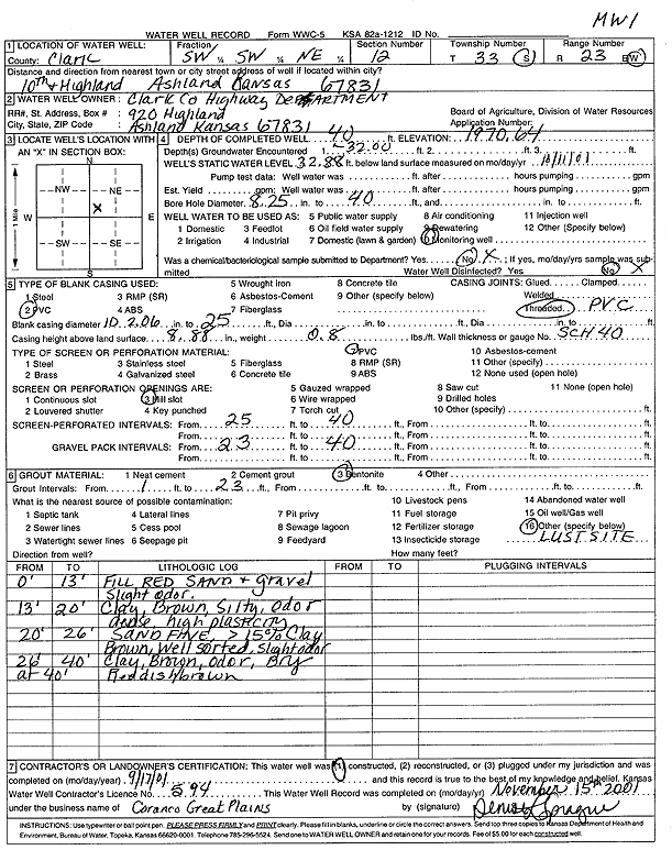
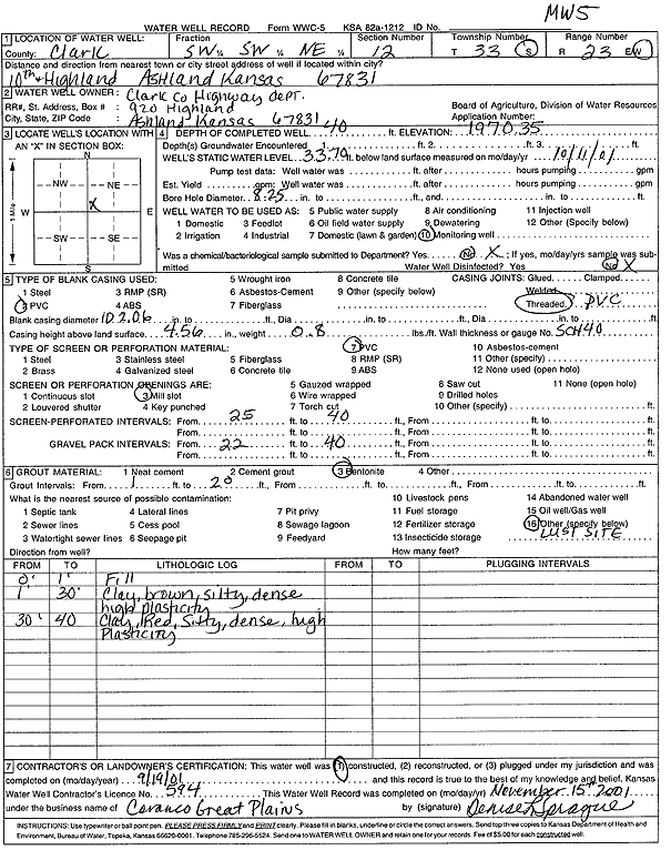
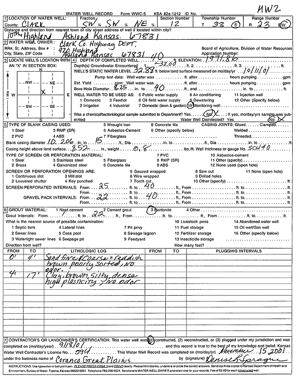
T33S, R23W, Sec. 12 SW SW NE |
Clark Co. Highway Dept. | 40 ft. | 32.88 ft. | Monitoring well/observation/piezometer | MW 1 | Constructed | 17-Sep-2001 | Scan | |
|
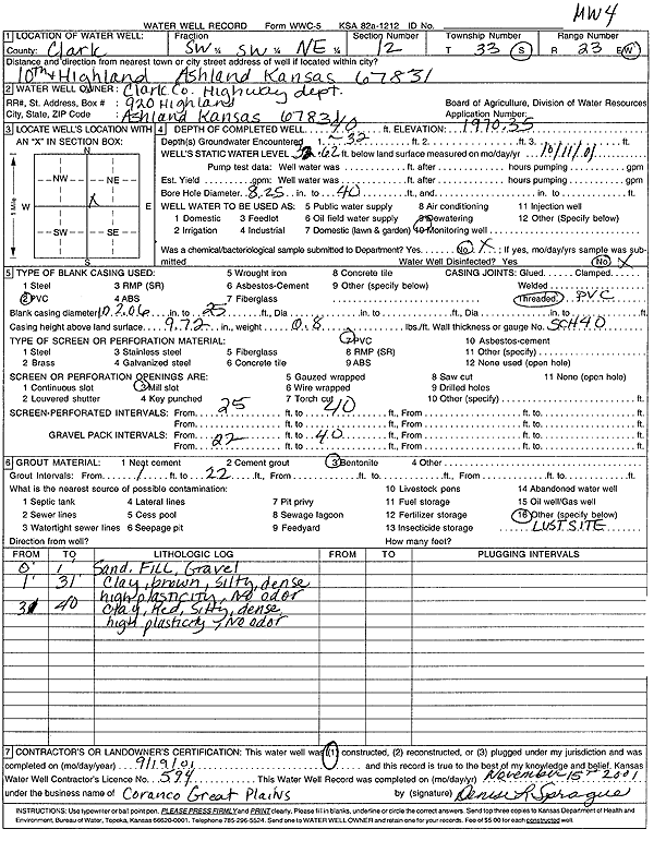
T33S, R23W, Sec. 12 SW SW NE |
Clark Co. Highway Dept. | 40 ft. | 32.62 ft. | Monitoring well/observation/piezometer | MW 4 | Constructed | 19-Sep-2001 | Scan | |
|
T33S, R23W, Sec. 12 SW SW NE |
Clark Co. Highway Dept. | 45 ft. | 36.5 ft. | Monitoring well/observation/piezometer | MW 6 | Constructed | 11-Sep-2008 | ||
|
T33S, R23W, Sec. 12 NE SW SW NE |
Clark Co. Highway Dept. | 55 ft. | 40.73 ft. | Monitoring well/observation/piezometer | MW 3R | Constructed | 13-May-2014 | ||
|
T33S, R23W, Sec. 12 NE SW SW NE |
Clark Co. Highway Dept. | 55 ft. | 41.18 ft. | Monitoring well/observation/piezometer | MW 9 | Constructed | 14-May-2014 | ||
|
T33S, R23W, Sec. 12 NW SE SW NE |
Clark Co. Highway Dept. | 39.78 ft. | Monitoring well/observation/piezometer | MW 5 | Plugged | 12-May-2014 | |||
|
T33S, R23W, Sec. 12 NW SE SW NE |
Clark Co. Highway Dept. | 39.23 ft. | Monitoring well/observation/piezometer | MW 4 | Plugged | 12-May-2014 | |||
|
T33S, R23W, Sec. 12 NW SE SW NE |
Clark Co. Highway Dept. | 39.6 ft. | Monitoring well/observation/piezometer | MW 3 | Plugged | 12-May-2014 | |||
|
T33S, R23W, Sec. 12 NE SW SW NE |
Clark Co. Highway Dept. | 55 ft. | 40.73 ft. | Monitoring well/observation/piezometer | MW 5R | Constructed | 14-May-2014 | ||
|
T33S, R23W, Sec. 12 NW SE SW NE |
Clark Co. Highway Dept. | 39.28 ft. | Monitoring well/observation/piezometer | MW 1 | Plugged | 12-May-2014 | |||
|
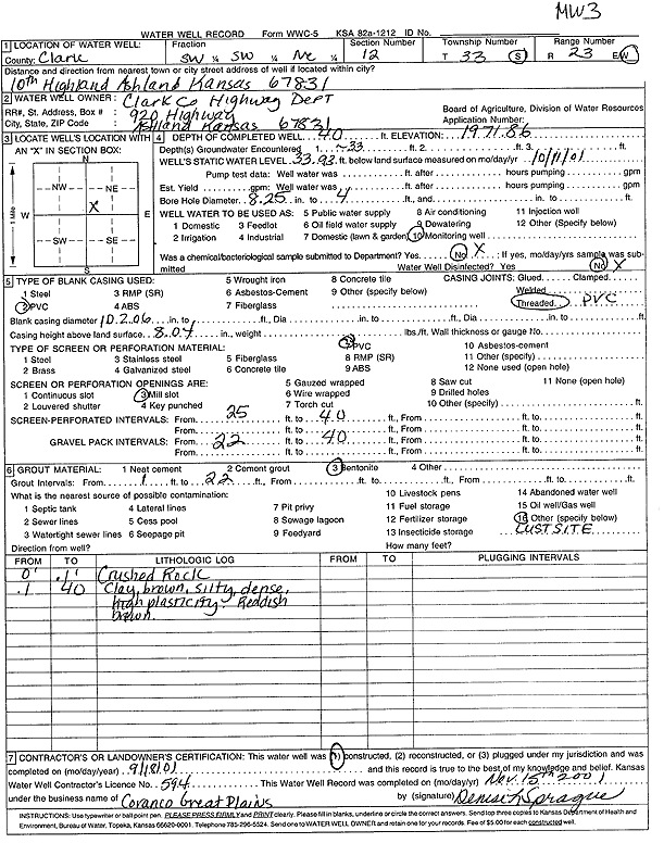
T33S, R23W, Sec. 12 SW SW NE |
Clark Co. Highway Dept. | 40 ft. | 33.93 ft. | Monitoring well/observation/piezometer | MW 3 | Constructed | 18-Sep-2001 | Scan | |
|
T33S, R23W, Sec. 12 SW SW NE |
Clark Co. Highway Dept. | 35.5 ft. | Monitoring well/observation/piezometer | MW 2 | Plugged | 12-Sep-2008 | |||
|
T33S, R23W, Sec. 12 SW SW NE |
Clark Co. Highway Dept. | 50 ft. | 36.75 ft. | Monitoring well/observation/piezometer | MW 12 | Constructed | 17-Oct-2024 |
KOLAR |
|
|
T33S, R23W, Sec. 12 SW SW NE |
Clark Co. Highway Dept. | 50 ft. | 38.01 ft. | Monitoring well/observation/piezometer | MW 11 | Constructed | 17-Oct-2024 |
KOLAR |
|
|
T33S, R23W, Sec. 12 SE SW NE |
Clark Co. Highway Dept. | 50 ft. | 38.22 ft. | Monitoring well/observation/piezometer | MW 10 | Constructed | 16-Oct-2024 |
KOLAR |
|
|
T33S, R23W, Sec. 12 SW SW NE |
Clark Co. Highway Dept. | 45 ft. | 36.85 ft. | Monitoring well/observation/piezometer | MW 2 R | Constructed | 11-Sep-2008 | ||
|
T33S, R23W, Sec. 12 SW SW NE |
Clark Co. Highway Dept. | 40 ft. | 33.7 ft. | Monitoring well/observation/piezometer | MW 5 | Constructed | 19-Sep-2001 | Scan | |
|
T33S, R23W, Sec. 12 SW SW NE |
Clark Co. Highway Dept. | 40 ft. | 32.88 ft. | Monitoring well/observation/piezometer | MW 2 | Constructed | 18-Sep-2001 | Scan | |
|
T33S, R23W, Sec. 12 NW SE SW NE |
Clark Co. Highway Dept. | 45 ft. | Monitoring well/observation/piezometer | MW 8 | Constructed | 19-Apr-2011 | |||
|
T33S, R23W, Sec. 12 NW SE SW NE |
Clark Co. Highway Dept. | 45 ft. | 47.76 ft. | Monitoring well/observation/piezometer | MW 7 | Constructed | 19-Apr-2011 | ||
|
T33S, R23W, Sec. 12 SW NE SE |
Dickey, Orval | 85 ft. | 30 ft. | Domestic | Constructed | 03-Apr-1975 | |||
|
T33S, R23W, Sec. 12 SW NE NE NE |
Eslinger, Edward | 88 ft. | 44 ft. | 50 gpm. | Domestic, Lawn and Garden | Constructed | 04-Aug-2016 |
KOLAR |
|
|
T33S, R23W, Sec. 12 NE NW SW |
Fellers, Tom | 120 ft. | 33 ft. | 3 gpm. | Domestic, Lawn and Garden | Constructed | 15-Aug-1990 | ||
| View page: < Prev || 11 || 12 || 13 || 14 || 15 || 16 || 17 || 18 || 19 || 20 || Next > | |||||||||