Select location of well to view details.
Click on column heading to sort.
|
|
|
County: Clark Select location of well to view details. Click on column heading to sort. |
|
|
|
| View page: < Prev || 21 || 22 || 23 || 24 || 25 || 26 || 27 || 28 || 29 | |||||||||
| T-R-S | Owner | Well Depth Ascend. Desc. |
Static Water Level Ascend. Desc. |
Est. Yield Ascend. Desc. |
Well Use | Other ID | Action Taken | Completion Date Ascend. Desc. |
Scan? |
|
T35S, R23W, Sec. 8 NE SW SW |
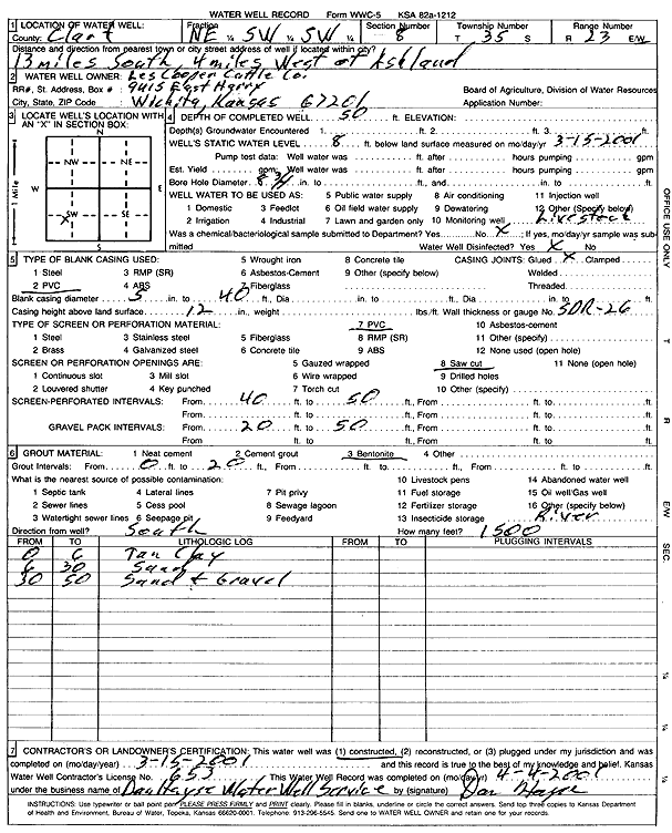
Les Cooper Cattle Co. | 50 ft. | 8 ft. | Domestic, Livestock | Constructed | 15-Mar-2001 | Scan | ||
|
T35S, R23W, Sec. 8 SW NW NE |
Triad Drilling | 100 ft. | 4 ft. | 150 gpm. | Oil Field Water Supply | Constructed | 05-Jul-1988 | ||
|
T35S, R23W, Sec. 9 N2 NE SW |
Dunne Ranch | 60 ft. | 6 ft. | 5 gpm. | Domestic, Livestock | Well 5 | Constructed | 20-Sep-2006 | |
|
T35S, R23W, Sec. 10 NW NW NW NW |
Gardiner Angus Ranch | 115 ft. | 45 ft. | 15 gpm. | Domestic, Livestock | Constructed | 10-Jul-2018 | ||
|
T35S, R23W, Sec. 11 SW NW SW |
Gardiner Angus Ranch | 126 ft. | 82 ft. | 5 gpm. | Domestic, Livestock | Constructed | 16-Jun-2022 |
KOLAR |
|
|
T35S, R23W, Sec. 12 NW NW NW |
Dunne Ranch | 94 ft. | 10 ft. | 50 gpm. | Domestic | Constructed | 18-Sep-2004 | ||
|
T35S, R23W, Sec. 12 SW SW NE |
Painter, Don | 70 ft. | 23 ft. | 100 gpm. | Domestic | Constructed | 12-Aug-2005 | ||
|
T35S, R23W, Sec. 12 NW NW NE |
Painter, Donald G. | 30 ft. | 20 ft. | Domestic, Livestock | Plugged | 22-Oct-2005 | |||
|
T35S, R24W, Sec. 1 C NE |
Rine Drilling Co. | 140 ft. | 15 ft. | 60 gpm. | Oil Field Water Supply | Dunn 1-1 | Constructed | 22-Mar-1985 | |
|
T35S, R24W, Sec. 2 SW SW NE SW |
Triangle H | 107 ft. | 9 ft. | 50 gpm. | Domestic, Livestock | Constructed | 20-Dec-2018 | ||
|
T35S, R24W, Sec. 8 NW SE SE |
Thies, Charlie | 120 ft. | 59 ft. | 5 gpm. | Domestic | Constructed | 10-Apr-1997 | ||
|
T35S, R24W, Sec. 9 SW SE SE |
Theis Ranch | 60 ft. | 15 ft. | 50 gpm. | Domestic | Constructed | 30-Mar-2000 | ||
|
T35S, R24W, Sec. 10 SW NE SE SE |
4 S Ranch | 100 ft. | 12 ft. | 50 gpm. | Domestic | Constructed | 27-Oct-2009 | ||
|
T35S, R25W, Sec. 1 NE NE NW |
Hink, Gene | 56 ft. | 21 ft. | 225 gpm. | Irrigation | Constructed | 13-Jul-1982 | ||
|
T35S, R25W, Sec. 1 SW NW NE |
Jerry's Service | 19.5 ft. | 14.81 ft. | Monitoring well/observation/piezometer | MW 8 | Constructed | 10-Mar-1994 | ||
|
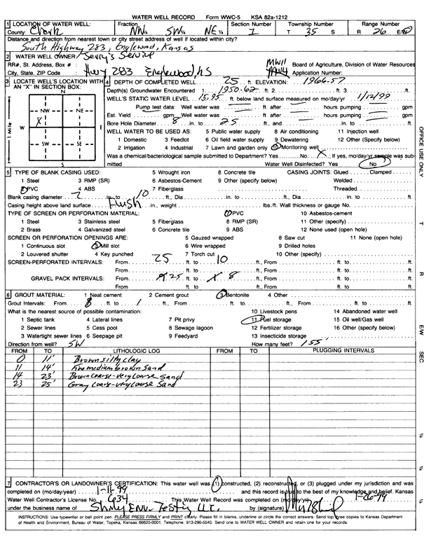
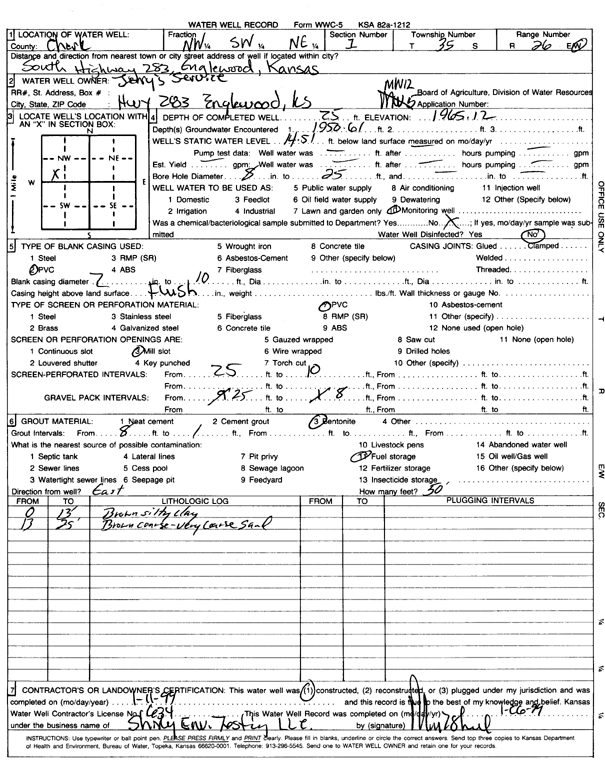
T35S, R25W, Sec. 1 NW SW NE |
Jerry's Service | 25 ft. | 15.95 ft. | Monitoring well/observation/piezometer | MW 11 | Constructed | 11-Jan-1999 | Scan | |
|
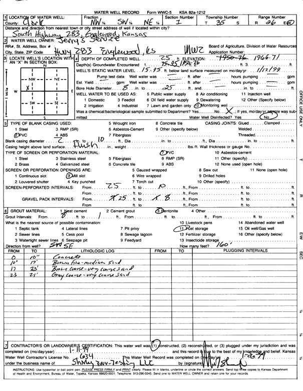
T35S, R25W, Sec. 1 NW SW NE |
Jerry's Service | 25 ft. | 15.95 ft. | Monitoring well/observation/piezometer | MW 2 | Constructed | 11-Jan-1999 | Scan | |
|
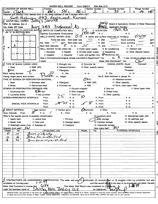
T35S, R25W, Sec. 1 NW SW NE |
Jerry's Service | 25 ft. | 15.15 ft. | Monitoring well/observation/piezometer | MW 6 | Constructed | 11-Jan-1999 | Scan | |
|
T35S, R25W, Sec. 1 SE NW NE |
Jerry's Service | 20 ft. | 13.51 ft. | Monitoring well/observation/piezometer | MW 4 | Plugged | 20-Feb-2002 | Scan | |
|
T35S, R25W, Sec. 1 NW SW NE |
Jerry's Service | 25 ft. | 14.51 ft. | Monitoring well/observation/piezometer | MW 12 | Constructed | 11-Jan-1999 | Scan | |
|
T35S, R25W, Sec. 1 SE NW NE |
Jerry's Service | 22 ft. | 15.2 ft. | Monitoring well/observation/piezometer | MW 5 | Plugged | 20-Feb-2002 | Scan | |
|
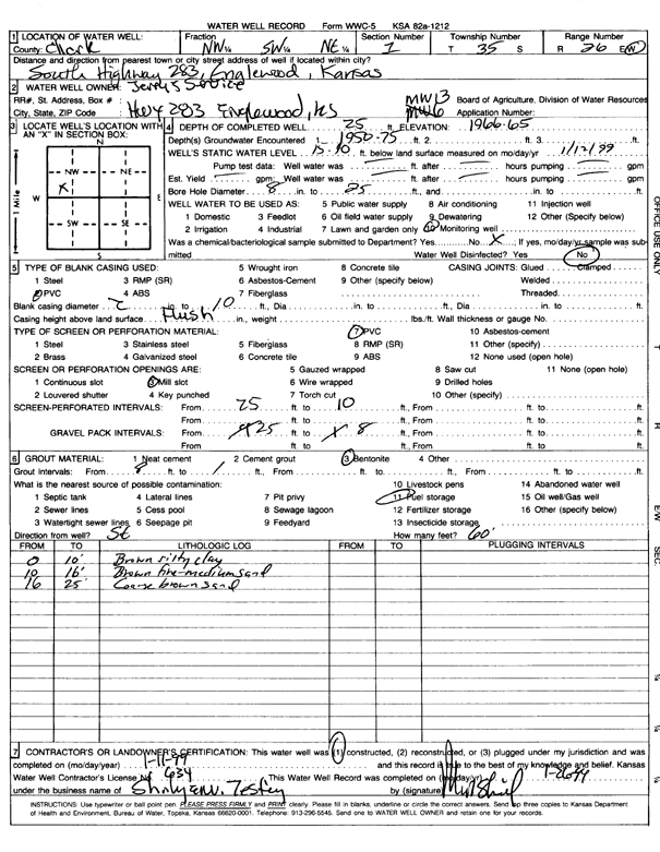
T35S, R25W, Sec. 1 NW SW NE |
Jerry's Service | 25 ft. | 15.4 ft. | Monitoring well/observation/piezometer | MW 13 | Constructed | 11-Jan-1999 | Scan | |
|
T35S, R25W, Sec. 1 SW NW NE |
Jerry's Service | 21.5 ft. | 10.29 ft. | Monitoring well/observation/piezometer | MW 5 | Constructed | 09-Mar-1994 | ||
|
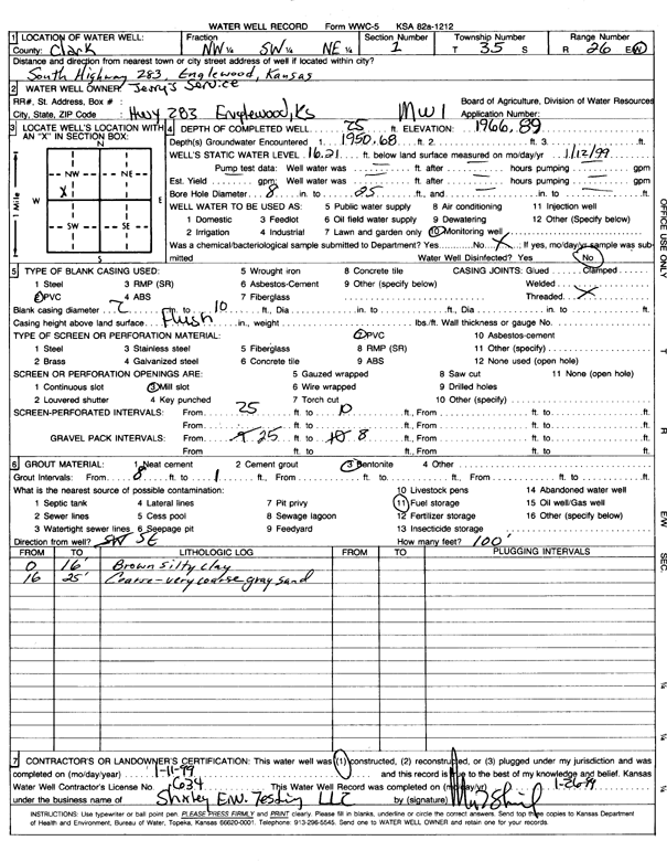
T35S, R25W, Sec. 1 NW SW NE |
Jerry's Service | 25 ft. | 16.21 ft. | Monitoring well/observation/piezometer | MW 1 | Constructed | 11-Jan-1999 | Scan | |
|
T35S, R25W, Sec. 1 SW NW NE |
Jerry's Service | 20.5 ft. | 14.33 ft. | Monitoring well/observation/piezometer | MW 4 | Constructed | 09-Mar-1994 | ||
|
T35S, R25W, Sec. 1 SW NW NE |
Jerry's Service | 23.5 ft. | 17.69 ft. | Monitoring well/observation/piezometer | MW 9 | Constructed | 15-Oct-1995 | ||
|
T35S, R25W, Sec. 1 SW NW NE |
Jerry's Service | 24.47 ft. | 16.73 ft. | Monitoring well/observation/piezometer | MW 10 | Constructed | 15-Oct-1995 | ||
|
T35S, R25W, Sec. 1 SE NW NE |
Jerry's Service | 16.01 ft. | Monitoring well/observation/piezometer | MW 7 | Plugged | 10-Nov-2009 | |||
|
T35S, R25W, Sec. 1 SW NW NE |
Jerry's Service | 20.5 ft. | 15.31 ft. | Monitoring well/observation/piezometer | MW 3 | Constructed | 09-Mar-1994 | ||
|
T35S, R25W, Sec. 1 SW NW NE |
Jerry's Service | 21.5 ft. | 15.48 ft. | Monitoring well/observation/piezometer | MW 7 | Constructed | 10-Mar-1994 | ||
|
T35S, R25W, Sec. 1 SW NW NE |
Roberts, Robin | 24.16 ft. | 16.91 ft. | Monitoring well/observation/piezometer | MW 4 R | Constructed | 16-Nov-2007 | ||
|
T35S, R25W, Sec. 1 NE SW NE |
Roberts, Robin | 65 ft. | 12 ft. | 100 gpm. | Domestic, Lawn and Garden | Constructed | 21-May-2025 |
KOLAR |
|
|
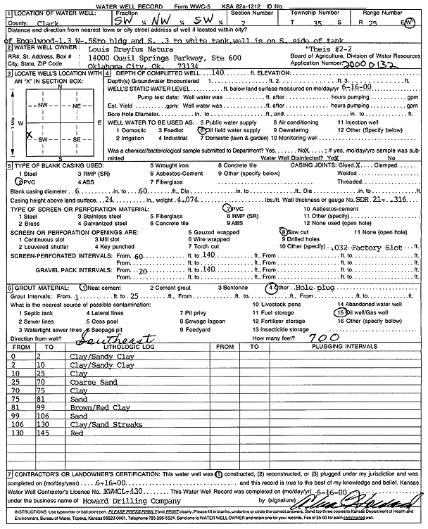
T35S, R25W, Sec. 2 SW NW SW |
Louis Dreyfus Natural Gas Corp. | 140 ft. | Oil Field Water Supply | Theis 2-2 | Constructed | 16-Jun-2000 | Scan | ||
|
T35S, R25W, Sec. 3 SW NW NE SW |
Goodnight, Greg | 73 ft. | 35 ft. | 3 gpm. | Domestic | Constructed | 19-Oct-2009 | ||
|
T35S, R25W, Sec. 4 SE SW NW NW |
Harrington, Gordon | 72 ft. | 42 ft. | 4 gpm. | Domestic, Livestock | Constructed | 20-Dec-2013 |
KOLAR |
|
|
T35S, R25W, Sec. 5 NE NE SW |
Charlie Theis Co. | 140 ft. | 54 ft. | 30 gpm. | Domestic | Constructed | 13-Mar-1997 | ||
|
T35S, R25W, Sec. 5 NW NE NE |
Goodnite, Greg | 100 ft. | 68 ft. | Domestic, Livestock | Constructed | 03-Feb-2023 |
KOLAR |
||
|
T35S, R25W, Sec. 6 NW NW SE |
Theis Co. | 100 ft. | 36 ft. | 5.5 gpm. | Domestic | Constructed | 12-May-1987 | ||
|
T35S, R25W, Sec. 11 NW SE NW NW |
Goodnight, Greg | 80 ft. | 23 ft. | 50 gpm. | Domestic | Constructed | 05-Nov-2009 | ||
|
T35S, R25W, Sec. 15 NE NE NE |
Unit Drilling Co. | 140 ft. | 20 ft. | Oil Field Water Supply | Theis D 1 | Constructed | 30-Jan-1975 | ||
|
T35S, R25W, Sec. 16 SW NE |
Sage Drilling Co. | 120 ft. | 40 ft. | 60 gpm. | Oil Field Water Supply | Theis 1-16 A | Constructed | 29-Apr-1978 | |
| View page: < Prev || 21 || 22 || 23 || 24 || 25 || 26 || 27 || 28 || 29 | |||||||||