Select location of well to view details.
Click on column heading to sort.
|
|
|
County: Clark Select location of well to view details. Click on column heading to sort. |
|
|
|
| View page: 1 || 2 || 3 || 4 || 5 || 6 || 7 || 8 || 9 || 10 || Next > | |||||||||
| T-R-S | Owner | Well Depth Ascend. Desc. |
Static Water Level Ascend. Desc. |
Est. Yield Ascend. Desc. |
Well Use | Other ID | Action Taken | Completion Date Ascend. Desc. |
Scan? |
|
T30S, R25W, Sec. 7 SE SE |
Ladd Petroleum | 140 ft. | 67 ft. | 40 gpm. | Oil Field Water Supply | Church 1-7 | Constructed | 28-Sep-1980 | |
|
T30S, R25W, Sec. 7 SE SE |
Ladd Petroleum | 140 ft. | 67 ft. | Oil Field Water Supply | Church 1-7 | Plugged | 07-Nov-1980 | ||
|
T30S, R25W, Sec. 8 C NE |
F.W.A. | 140 ft. | 60 ft. | 40 gpm. | Oil Field Water Supply | Church 3 | Constructed | 10-Jul-1982 | |
|
T30S, R25W, Sec. 8 N2 NW SE |
Ladd Petroleum | 180 ft. | 60 ft. | 60 gpm. | Oil Field Water Supply | Cannon 1-8 | Constructed | 14-Aug-1980 | |
|
T30S, R25W, Sec. 8 NW SW NE |
Ladd Petroleum | 180 ft. | 57 ft. | 60 gpm. | Oil Field Water Supply | Norton 1--8 | Constructed | 24-Jul-1980 | |
|
T30S, R25W, Sec. 8 NW SW NE |
Ladd Petroleum | 180 ft. | 57 ft. | Oil Field Water Supply | Norton 1-8 | Plugged | 26-Sep-1980 | ||
|
T30S, R25W, Sec. 8 N2 NW SE |
Ladd Petroleum | 180 ft. | 60 ft. | Oil Field Water Supply | Cannon 1-8 | Plugged | 26-Sep-1980 | ||
|
T30S, R25W, Sec. 8 SE SE NE |
Norton, Robert | 155 ft. | 70 ft. | 60 gpm. | Oil Field Water Supply | Constructed | 28-Aug-1982 | ||
|
T30S, R25W, Sec. 8 SE SE NW |
Slawson Drilling Co. | 135 ft. | 62 ft. | 75 gpm. | Oil Field Water Supply | Church 1 | Constructed | 02-Jun-1981 | |
|
T30S, R25W, Sec. 8 SE NE SW |
Wears, E.T. | 145 ft. | 65 ft. | 60 gpm. | Oil Field Water Supply | Wears 2 | Constructed | 12-Dec-1981 | |
|
T30S, R25W, Sec. 8 NE NW SW |
Wears, E.T. | 140 ft. | 55 ft. | Oil Field Water Supply | Wears 1 | Plugged | 18-Feb-1981 | ||
|
T30S, R25W, Sec. 8 NE NW SW |
Wears, E.T. | 140 ft. | 55 ft. | 50 gpm. | Oil Field Water Supply | Wears 1 | Constructed | 17-Jan-1981 | |
|
T30S, R25W, Sec. 9 SW SW NW |
Alley, M.E. | 160 ft. | 60 ft. | 45 gpm. | Oil Field Water Supply | Alley 1 | Constructed | 15-Dec-1982 | |
|
T30S, R25W, Sec. 9 SW SE NW |
Alley, Robert D. | 123 ft. | 57 ft. | Oil Field Water Supply | Alley 1 | Constructed | 03-Jun-1988 | ||
|
T30S, R25W, Sec. 9 NW NE NE |
Freeman Drilling Co. | 140 ft. | 70 ft. | 50 gpm. | Oil Field Water Supply | Norton B 1 | Constructed | 24-Feb-1983 | |
|
T30S, R25W, Sec. 9 C SW SW |
Harris, R. | 155 ft. | 62 ft. | 60 gpm. | Oil Field Water Supply | Harris 2 | Constructed | 04-Aug-1982 | |
|
T30S, R25W, Sec. 9 SW NE SE |
Norton, William/Murfin Drilling Co. | 160 ft. | 60 ft. | 55 gpm. | Oil Field Water Supply | Norton 1-9 | Constructed | 09-Apr-1985 | |
|
T30S, R25W, Sec. 9 NW SW SW |
Williamson, H.F. | 145 ft. | 55 ft. | Oil Field Water Supply | Harris 1 | Plugged | 08-Feb-1981 | ||
|
T30S, R25W, Sec. 9 NW SW SW |
Williamson, H.F. | 145 ft. | 55 ft. | 50 gpm. | Oil Field Water Supply | Harris 1 | Constructed | 16-Jan-1981 | |
|
T30S, R25W, Sec. 10 NE NE SE SW |
Jaeger Enterprises, LLC | 145 ft. | 66 ft. | 40 gpm. | Domestic | Constructed | 30-Mar-2020 |
KOLAR |
|
|
T30S, R25W, Sec. 10 SE SE NW |
Murfin Drilling Co. | 135 ft. | 70 ft. | 70 gpm. | Oil Field Water Supply | Tedford 2-10 | Constructed | 21-Apr-1983 | |
|
T30S, R25W, Sec. 10 SE SE NW |
Patton, Harold | 111 ft. | 77 ft. | Domestic | Constructed | 20-Apr-1998 | |||
|
T30S, R25W, Sec. 10 NW NW NW |
Tedford, F.L. | 140 ft. | 65 ft. | 50 gpm. | Oil Field Water Supply | Tedford 1 | Constructed | 19-Nov-1980 | |
|
T30S, R25W, Sec. 10 NW NW NW |
Tedford, F.L. | 140 ft. | 65 ft. | Oil Field Water Supply | Tedford 1 | Plugged | 07-Jan-1981 | ||
|
T30S, R25W, Sec. 11 C NE NE |
Eagle Drilling Co. | 130 ft. | 80 ft. | 60 gpm. | Oil Field Water Supply | Rooney 1 | Constructed | 23-Oct-1986 | |
|
T30S, R25W, Sec. 11 NW NW SE |
Jacger, Luke | 125 ft. | 65 ft. | Domestic | Constructed | 16-Sep-2011 | |||
|
T30S, R25W, Sec. 11 C NW NE |
Ladd Petroleum | 200 ft. | 80 ft. | 60 gpm. | Oil Field Water Supply | Rooney 1-11 | Constructed | 12-Dec-1983 | |
|
T30S, R25W, Sec. 11 C N2 NW |
Latzke, W. | 155 ft. | 75 ft. | 65 gpm. | Oil Field Water Supply | Latzke 1-11 | Constructed | 29-Aug-1982 | |
|
T30S, R25W, Sec. 11 NW NW SW |
Norton, Gail | 110 ft. | 56 ft. | Domestic | Constructed | 09-Sep-2010 | |||
|
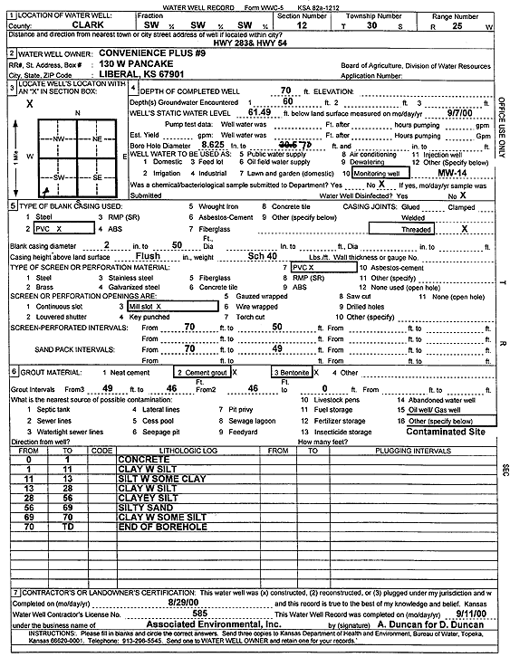
T30S, R25W, Sec. 12 SW SW SW |
Convenience Plus 9 | 70 ft. | 61.49 ft. | Monitoring well/observation/piezometer | MW 14 | Constructed | 29-Aug-2000 | Scan | |
|
T30S, R25W, Sec. 12 SW SW SW |
Convenience Plus 9 | 70.2 ft. | 59.85 ft. | Monitoring well/observation/piezometer | MW 5 | Constructed | 16-Feb-2000 | Scan | |
|
T30S, R25W, Sec. 12 SW SW SW |
Convenience Plus 9 | 70.2 ft. | 61.81 ft. | Monitoring well/observation/piezometer | MW 7 | Constructed | 16-Feb-2000 | Scan | |
|
T30S, R25W, Sec. 12 SW SW SW |
Convenience Plus 9 | 70 ft. | 60.76 ft. | Monitoring well/observation/piezometer | MW 6 | Constructed | 16-Feb-2000 | Scan | |
|
T30S, R25W, Sec. 12 SW SW SW |
Convenience Plus 9 | 70 ft. | 59.87 ft. | Monitoring well/observation/piezometer | MW 2 | Constructed | 16-Feb-2000 | Scan | |
|
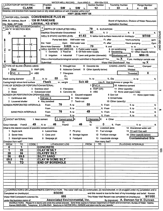
T30S, R25W, Sec. 12 SW SW SW |
Convenience Plus 9 | 70 ft. | 61.63 ft. | Monitoring well/observation/piezometer | MW 16 | Constructed | 30-Aug-2000 | Scan | |
|
T30S, R25W, Sec. 12 SW SW SW |
Convenience Plus 9 | 70.2 ft. | 60.13 ft. | Monitoring well/observation/piezometer | MW 1 | Constructed | 16-Feb-2000 | Scan | |
|
T30S, R25W, Sec. 12 SW SW SW |
Convenience Plus 9 | 70.7 ft. | 61.95 ft. | Monitoring well/observation/piezometer | MW 10 | Constructed | 16-Feb-2000 | Scan | |
|
T30S, R25W, Sec. 12 SW SW SW |
Convenience Plus 9 | 70.2 ft. | 60.28 ft. | Monitoring well/observation/piezometer | MW 11 | Constructed | 16-Feb-2000 | Scan | |
|
T30S, R25W, Sec. 12 SW SW SW |
Convenience Plus 9 | 70 ft. | 61.21 ft. | Monitoring well/observation/piezometer | MW 15 | Constructed | 29-Aug-2000 | Scan | |
|
T30S, R25W, Sec. 12 SW SW SW |
Convenience Plus 9 | 70.2 ft. | 60.47 ft. | Monitoring well/observation/piezometer | MW 4 | Constructed | 16-Feb-2000 | Scan | |
|
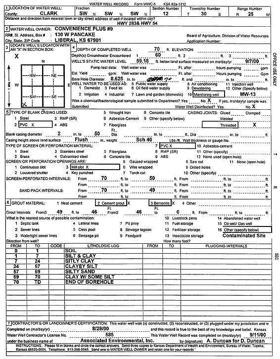
T30S, R25W, Sec. 12 SW SW SW |
Convenience Plus 9 | 70 ft. | 59.18 ft. | Monitoring well/observation/piezometer | MW 13 | Constructed | 29-Aug-2000 | Scan | |
|
T30S, R25W, Sec. 12 SW SW SW |
Convenience Plus 9 | 70.2 ft. | 59.11 ft. | Monitoring well/observation/piezometer | MW 9 | Constructed | 16-Feb-2000 | Scan | |
|
T30S, R25W, Sec. 12 SW SW SW |
Convenience Plus 9 | 70.2 ft. | 59.98 ft. | Monitoring well/observation/piezometer | MW 8 | Constructed | 16-Feb-2000 | Scan | |
|
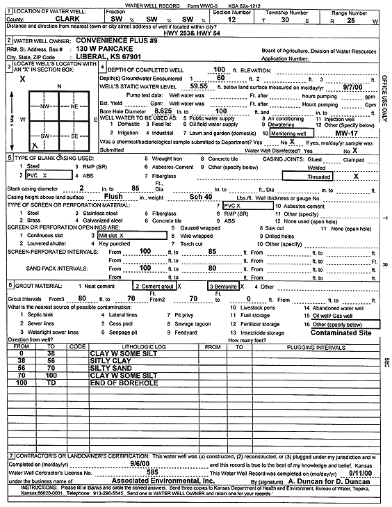
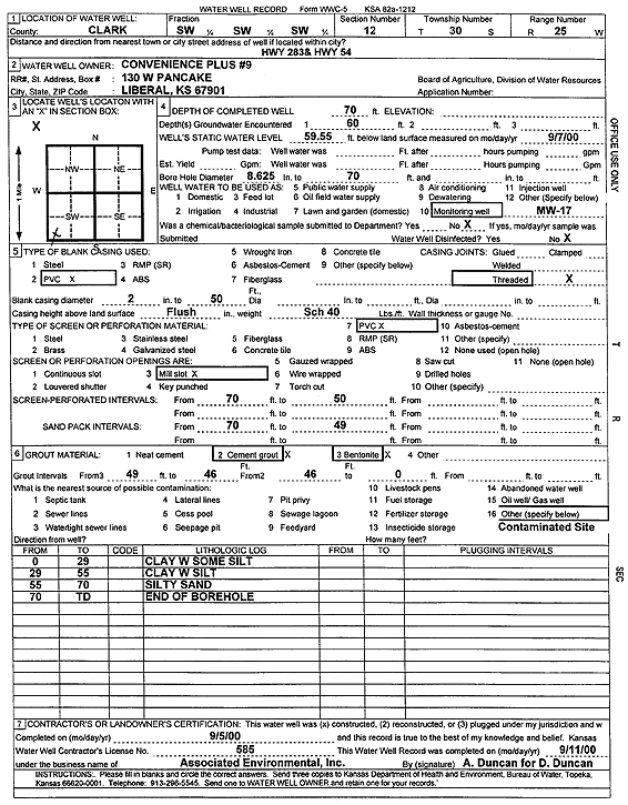
T30S, R25W, Sec. 12 SW SW SW |
Convenience Plus 9 | 100 ft. | 59.55 ft. | Monitoring well/observation/piezometer | MW 17 | Constructed | 06-Sep-2000 | Scan | |
|
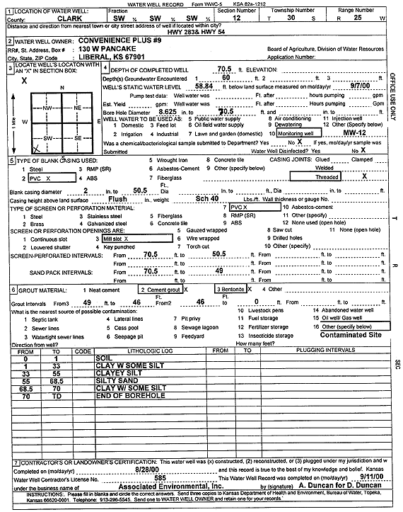
T30S, R25W, Sec. 12 SW SW SW |
Convenience Plus 9 | 70 ft. | 59.55 ft. | Monitoring well/observation/piezometer | MW 17 | Constructed | 05-Sep-2000 | Scan | |
|
T30S, R25W, Sec. 12 SW SW SW |
Convenience Plus 9 | 70.2 ft. | 60.47 ft. | Monitoring well/observation/piezometer | MW 3 | Constructed | 16-Feb-2000 | Scan | |
|
T30S, R25W, Sec. 12 SW SW SW |
Convenience Plus 9 | 70.5 ft. | 58.84 ft. | Monitoring well/observation/piezometer | MW 12 | Constructed | 28-Aug-2000 | Scan | |
|
T30S, R25W, Sec. 12 NE SE SE |
Eagle Drilling Co. | 140 ft. | 81 ft. | 70 gpm. | Oil Field Water Supply | Rogers 1 | Constructed | 04-Nov-1982 | |
|
T30S, R25W, Sec. 12 SE SE SW |
Hensley, Bruce | 140 ft. | 75 ft. | 20 gpm. | Domestic | Constructed | 30-Jun-1988 | ||
|
T30S, R25W, Sec. 12 NW NE NE |
Murfin Drilling Co. | 215 ft. | 85 ft. | 50 gpm. | Oil Field Water Supply | Statton 1-12 | Constructed | 11-Feb-1985 | |
| View page: 1 || 2 || 3 || 4 || 5 || 6 || 7 || 8 || 9 || 10 || Next > | |||||||||