Select location of well to view details.
Click on column heading to sort.
|
|
|
County: Clark Select location of well to view details. Click on column heading to sort. |
|
|
|
| View page: 1 || 2 || 3 || 4 || 5 || 6 || 7 || 8 || 9 || 10 || Next > | |||||||||
| T-R-S | Owner | Well Depth Ascend. Desc. |
Static Water Level Ascend. Desc. |
Est. Yield Ascend. Desc. |
Well Use | Other ID | Action Taken | Completion Date Ascend. Desc. |
Scan? |
|
T31S, R21W, Sec. 34 SE SE SE |
Harden, Willis | 93 ft. | 78 ft. | 5 gpm. | Domestic | Constructed | 03-Nov-1977 | ||
|
T31S, R21W, Sec. 36 NW SW SE NW |
Holcomb, Keith | 120 ft. | 19 ft. | 15 gpm. | Domestic | Constructed | 27-Jun-2016 | ||
|
T31S, R21W, Sec. 36 NW NW SE |
Rich, Danny | 60 ft. | 15 ft. | 30 gpm. | Domestic | Constructed | 22-Jul-1999 | ||
|
T31S, R22W, Sec. 9 SE SW SE |
Giles, Norman | 80 ft. | 28 ft. | 5 gpm. | Domestic | Constructed | 26-May-2007 | ||
|
T31S, R22W, Sec. 10 NE NW NW |
Falcon Exploration, Inc. | 80 ft. | 20 ft. | 90 gpm. | Oil Field Water Supply | Constructed | 23-Sep-2006 | ||
|
T31S, R22W, Sec. 10 C NE NE NW |
Giles Ranch | 50 ft. | 16 ft. | 32 gpm. | Oil Field Water Supply | Constructed | 20-Jul-2006 | ||
|
T31S, R22W, Sec. 10 NW NE NE |
Giles Ranch | 46 ft. | 15 ft. | Domestic, Livestock | Constructed | 26-Dec-2005 | |||
|
T31S, R22W, Sec. 10 SW SW NE |
Giles Ranch | 80 ft. | 35 ft. | 10 gpm. | Domestic | Constructed | 09-Oct-1987 | ||
|
T31S, R22W, Sec. 10 SE SE NW |
Giles Ranch | 40 ft. | 23 ft. | Domestic | Plugged | 05-May-1993 | |||
|
T31S, R22W, Sec. 11 NW SW NE |
Falcon Expl Inc | 80 ft. | 8 ft. | 100 gpm. | Oil Field Water Supply | NE Fulton 1-11 | Constructed | 29-Jun-2007 | |
|
T31S, R22W, Sec. 14 SW NW NE |
Giles, Norman Lee | 104 ft. | 18 ft. | 700 gpm. | Irrigation | Constructed | 21-Apr-1977 | ||
|
T31S, R22W, Sec. 17 SW SW SE |
Young Brothers Cattle Co. | 16 ft. | 9 ft. | Domestic, Livestock | Plugged | 25-Aug-2004 | |||
|
T31S, R22W, Sec. 17 SW SW SE |
Young Brothers Cattle Co. | 40 ft. | 15 ft. | Domestic, Livestock | Constructed | 25-Aug-2004 | |||
|
T31S, R22W, Sec. 17 SW SW SE |
Young Brothers Cattle Co. | 22 ft. | 11 ft. | Domestic | Constructed | 09-Aug-1998 | |||
|
T31S, R22W, Sec. 19 SW SW NE |
Beckerdite, Cameron | 150 ft. | 104 ft. | 30 gpm. | Domestic | Constructed | 19-Jun-1992 | ||
|
T31S, R22W, Sec. 19 W2 W2 SW |
Seacat, R.J. | 84 ft. | 20 ft. | 15 gpm. | Feedlot | Constructed | 01-Jun-1982 | ||
|
T31S, R22W, Sec. 22 SE SW SW |
Broadie | 40 ft. | 9 ft. | Domestic, Livestock | Constructed | 23-Dec-2005 | |||
|
T31S, R22W, Sec. 24 C NE NE |
Giles, N. | 70 ft. | 12 ft. | 50 gpm. | Oil Field Water Supply | Constructed | 26-May-1981 | ||
|
T31S, R22W, Sec. 25 NE SE NE |
Ashland Feeders | 90 ft. | 25 ft. | Domestic | Constructed | 04-May-2023 |
KOLAR |
||
|
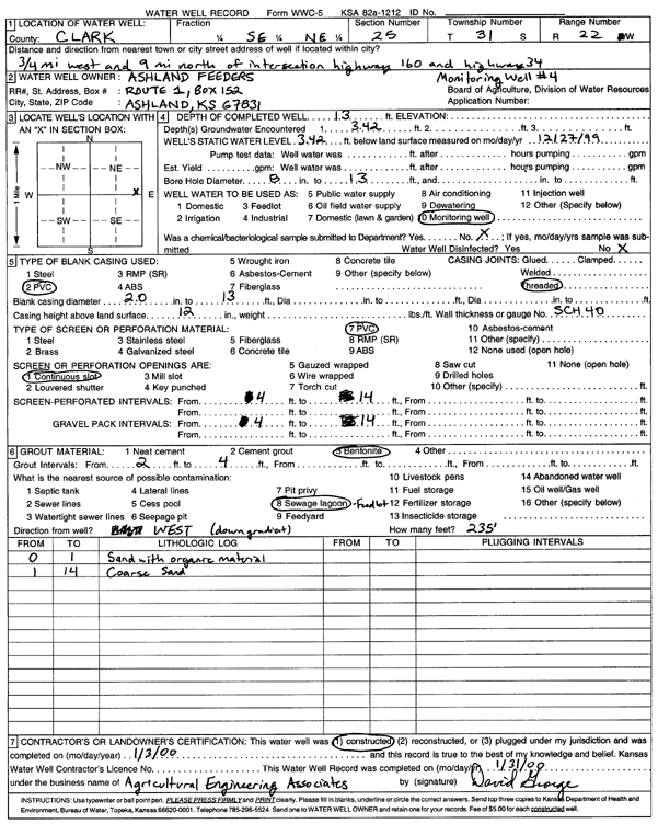
T31S, R22W, Sec. 25 SE NE |
Ashland Feeders | 13 ft. | 3.42 ft. | Monitoring well/observation/piezometer | MW 4 | Constructed | 03-Jan-2000 | Scan | |
|
T31S, R22W, Sec. 25 NE SE NE |
Ashland Feeders | 90 ft. | 25 ft. | 30 gpm. | Domestic | Constructed | 05-May-2023 |
KOLAR |
|
|
T31S, R22W, Sec. 25 SE NE |
Ashland Feeders | 16.5 ft. | 7 ft. | Monitoring well/observation/piezometer | MW 6 | Constructed | 03-Jan-2000 | Scan | |
|
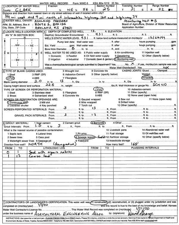
T31S, R22W, Sec. 25 NE SE |
Ashland Feeders | 13 ft. | 4.31 ft. | Monitoring well/observation/piezometer | MW 5 | Constructed | 03-Jan-2000 | Scan | |
|
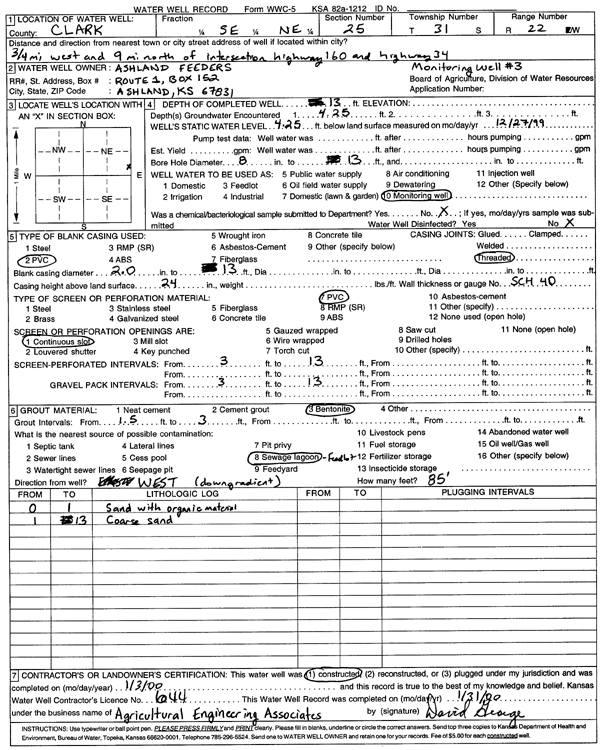
T31S, R22W, Sec. 25 SE NE |
Ashland Feeders | 13 ft. | 4.25 ft. | Monitoring well/observation/piezometer | MW 3 | Constructed | 13-Jan-2000 | Scan | |
|
T31S, R22W, Sec. 25 W2 W2 NE |
Sho-Bar Energy | 160 ft. | 20 ft. | 120 gpm. | Oil Field Water Supply | Clark 1 | Constructed | 07-May-1997 | |
|
T31S, R22W, Sec. 27 C SW |
Ladd Petroleum | 100 ft. | 5 ft. | 40 gpm. | Oil Field Water Supply | Sawyer 1-27 | Constructed | 11-May-1985 | |
|
T31S, R22W, Sec. 27 NE NE SW |
Pike, Brad | 70 ft. | Domestic | Constructed | 05-Sep-2005 | ||||
|
T31S, R22W, Sec. 33 NW NW SE |
Waits, Jess | 100 ft. | 46 ft. | 3 gpm. | Domestic, Livestock | Constructed | 17-Jan-1983 | ||
|
T31S, R22W, Sec. 35 SW NW NE |
Waits, Jess | 45 ft. | 17 ft. | 15 gpm. | Domestic | Constructed | 18-Jun-1981 | ||
|
T31S, R22W, Sec. 36 SW SW SW |
Beal, Melvin | 90 ft. | 26 ft. | 20 gpm. | Domestic | Constructed | 27-Jan-1977 | ||
|
T31S, R22W, Sec. 36 SW SW SE |
Rich, Dan | 85 ft. | 30 ft. | 25 gpm. | Domestic | Constructed | 19-Jan-1980 | ||
|
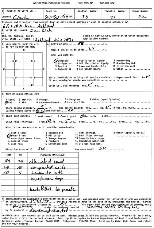
T31S, R22W, Sec. 36 SE SW SE |
Rich, Dan | 89 ft. | 24 ft. | Domestic | Plugged | 23-Aug-1999 | Scan | ||
|
T31S, R22W, Sec. 36 SE NW NW NE |
Rich, Dan | 77 ft. | 25 ft. | 50 gpm. | Domestic, Livestock | Constructed | 03-Sep-2014 |
KOLAR |
|
|
T31S, R23W, Sec. 4 NW NW NW |
Miller, Emma Jean | 130 ft. | 75 ft. | Domestic | Constructed | 27-Aug-1998 | |||
|
T31S, R23W, Sec. 4 SW NE SW |
Rine Drilling | 275 ft. | 140 ft. | Oil Field Water Supply | Cossman Estate 1 | Constructed | 27-May-1975 | ||
|
T31S, R23W, Sec. 7 NW NW NE |
Arnold, Jim | 180 ft. | 120 ft. | 30 gpm. | Domestic | Constructed | 24-Apr-1990 | ||
|
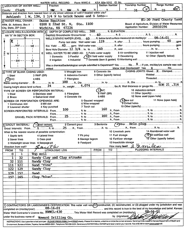
T31S, R23W, Sec. 7 NW NW NW |
Dunne Equities | 160 ft. | 60 ft. | 40 gpm. | Oil Field Water Supply | Ford County Land 1-30 | Constructed | 16-Aug-2001 | Scan |
|
T31S, R23W, Sec. 16 SW SE NE |
Bouziden, David | 100 ft. | 66 ft. | 5 gpm. | Domestic | Location 1 | Constructed | 27-Feb-1991 | |
|
T31S, R23W, Sec. 16 SW SW NW |
Bouziden, David | 85 ft. | 35 ft. | 8 gpm. | Domestic | Location 3 | Constructed | 28-Feb-1991 | |
|
T31S, R23W, Sec. 20 NW NE SE |
Young, Cooper, and Herrmann | 110 ft. | 73 ft. | 5 gpm. | Domestic | Constructed | 22-Oct-1990 | ||
|
T31S, R23W, Sec. 21 NE NE SW |
Bouziden, David | 50 ft. | 15 ft. | 4 gpm. | Domestic | Location 4 | Constructed | 12-Apr-1991 | |
|
T31S, R23W, Sec. 24 SW SE SE |
Beckerdite, Cameron | 160 ft. | 55 ft. | 20 gpm. | Domestic | Constructed | 04-Oct-1991 | ||
|
T31S, R23W, Sec. 29 SE SW NW |
Arnold, Jim | 300 ft. | 248 ft. | 5 gpm. | Domestic | Constructed | 02-May-1990 | ||
|
T31S, R23W, Sec. 30 SW SW SW |
Arnold, Jim | 180 ft. | 81 ft. | 10 gpm. | Domestic | Constructed | 07-Jun-1990 | ||
|
T31S, R24W, Sec. 2 NW NE NW NW |
McFadden, Ron | 180 ft. | 103 ft. | 10 gpm. | Domestic, Livestock | Constructed | 21-Apr-2022 | ||
|
T31S, R24W, Sec. 3 SE SE NE |
McFadden, B.J. | 140 ft. | 107 ft. | 7 gpm. | Domestic, Livestock | Constructed | 11-Jul-1978 | ||
|
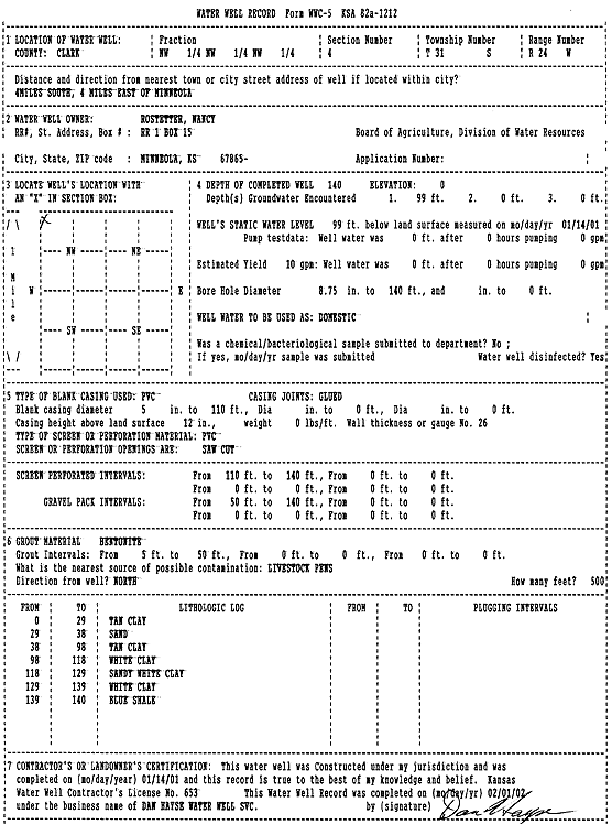
T31S, R24W, Sec. 4 NW NW NW |
Rostetter, Nancy | 140 ft. | 99 ft. | 10 gpm. | Domestic | Constructed | 14-Jan-2001 | Scan | |
|
T31S, R24W, Sec. 11 SW NE NE |
Bouziden, Dave | 120 ft. | 112 ft. | Domestic | Plugged | 21-Apr-1993 | |||
|
T31S, R24W, Sec. 11 NW NE NE |
Bouziden, Dave | 190 ft. | 111 ft. | 6 gpm. | Domestic | Constructed | 19-Apr-1993 | ||
|
T31S, R24W, Sec. 11 NW NE NE NE |
Bouziden, David | 145 ft. | 98 ft. | Domestic, Livestock | Reconstructed | 20-Jan-2018 | |||
| View page: 1 || 2 || 3 || 4 || 5 || 6 || 7 || 8 || 9 || 10 || Next > | |||||||||