Select location of well to view details.
Click on column heading to sort.
|
|
|
County: Coffey Select location of well to view details. Click on column heading to sort. |
|
|
|
| View page: 1 || 2 || 3 || 4 || 5 || 6 || 7 || 8 || 9 || 10 || Next > | |||||||||
| T-R-S | Owner | Well Depth Ascend. Desc. |
Static Water Level Ascend. Desc. |
Est. Yield Ascend. Desc. |
Well Use | Other ID | Action Taken | Completion Date Ascend. Desc. |
Scan? |
|---|---|---|---|---|---|---|---|---|---|
|
T21S, R14E, Sec. 19 NW NW NW |
Anderson, Larry | 160 ft. | 15 ft. | .5 gpm. | Domestic | Constructed | 20-Jul-1992 | ||
|
T21S, R17E, Sec. 8 NW NW NW |
Andress, William | 100 ft. | 50 ft. | 9 gpm. | Domestic | Constructed | 30-May-1979 | ||
|
T22S, R16E, Sec. 34 NE |
Arnold, Harry | 45 ft. | 20 ft. | 100 gpm. | Domestic, Lawn and Garden | Constructed | 11-Jul-1978 | ||
|
T23S, R14E, Sec. 2 NE NE NE |
Bahr, Rudolph | 33 ft. | 27 ft. | Domestic | Plugged | 19-Jul-1997 | |||
|
T19S, R16E, Sec. 7 NW NW SW |
Bailey, Kevin | 90 ft. | 22 ft. | 2.5 gpm. | Domestic | Constructed | 15-Apr-1997 | ||
|
T21S, R17E, Sec. 20 NE NW NW |
Baker, Russell | 100 ft. | 23 ft. | 4 gpm. | Domestic | Constructed | 23-Jun-1992 | ||
|
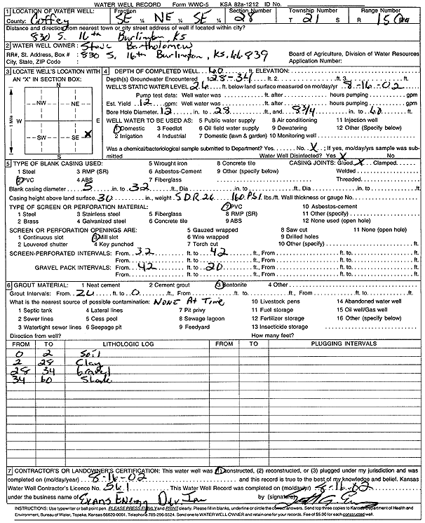
T21S, R15E, Sec. 28 SE NE SE |
Bartholomew, Steve | 60 ft. | 26 ft. | 12 gpm. | Domestic | Constructed | 16-Aug-2002 | Scan | |
|
T19S, R16E, Sec. 10 SE SE NE |
Bartlett, Curtis | 240 ft. | 160 ft. | 3 gpm. | Domestic | Constructed | 09-Feb-1977 | ||
|
T19S, R16E, Sec. 15 SE NE NE |
Bartlett, Curtis | 260 ft. | 205 ft. | 5 gpm. | Domestic | Constructed | 14-Nov-1991 | ||
|
T23S, R16E, Sec. 1 NW NW NW |
Beard, M. O. | 40 ft. | 20 ft. | 100 gpm. | Domestic | Constructed | 08-Apr-1977 | ||
|
T23S, R16E, Sec. 1 NE NE NE |
Beard, M. O. | 23 ft. | 5 ft. | Domestic | Plugged | 07-Aug-1994 | |||
|
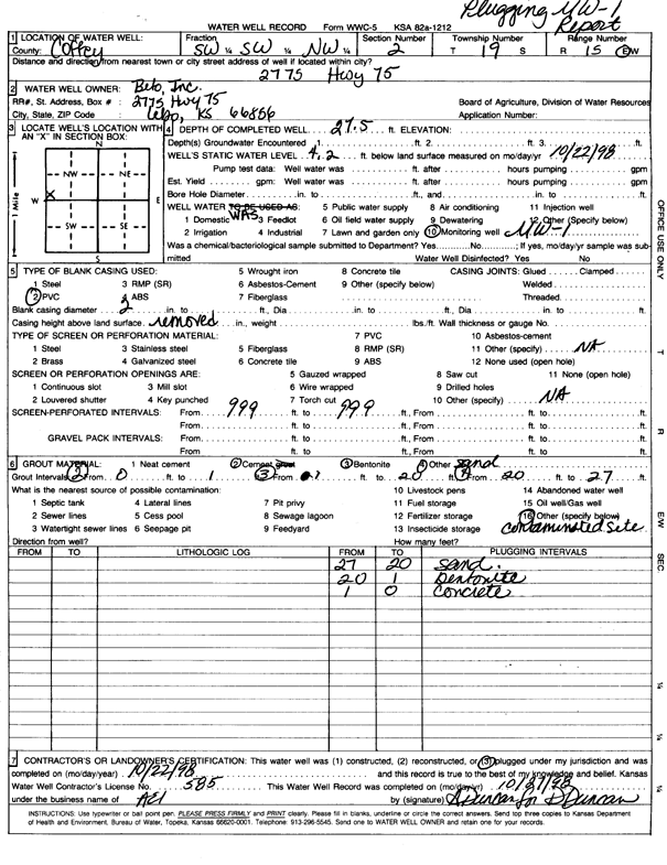
T19S, R15E, Sec. 2 SW SW NW |
Beto, Incorporated | 27.5 ft. | 4.2 ft. | Monitoring well/observation/piezometer | MW 1 | Plugged | 22-Oct-1998 | Scan | |
|
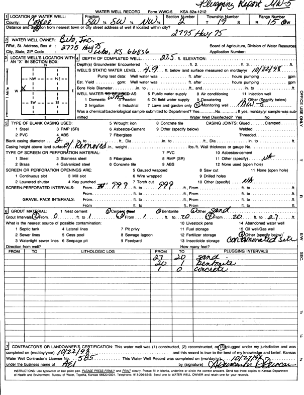
T19S, R15E, Sec. 2 SW SW NW |
Beto, Incorporated | 27.5 ft. | 4.9 ft. | Monitoring well/observation/piezometer | MW 5 | Plugged | 22-Oct-1998 | Scan | |
|
T21S, R15E, Sec. 17 SE SE SE |
Birkbeck, Stan | 28 ft. | 6 ft. | 100 gpm. | Domestic | Constructed | 29-Jun-1987 | ||
|
T21S, R15E, Sec. 21 NW NE SE |
Blauffus, Vic | 39 ft. | 11 ft. | 7 gpm. | Domestic, Lawn and Garden | Constructed | 06-Apr-2009 | ||
|
T21S, R15E, Sec. 33 SW SW SW |
Botkin, Danny | 60 ft. | Domestic | Plugged | 07-Jun-2000 | Scan | |||
|
T19S, R16E, Sec. 24 NW NE |
Brown, Earl | 170 ft. | 145 ft. | 7 gpm. | (unstated)/abandoned | Constructed | 14-Sep-1965 | ||
|
T21S, R15E, Sec. 28 NE NW SE |
Bull, Jim | 65 ft. | 7.25 ft. | 10 gpm. | Domestic | Constructed | 27-May-1989 | ||
|
T21S, R15E, Sec. 33 SW SW SW |
Bull, Virgil | 90 ft. | 14 ft. | 2 gpm. | Domestic | Constructed | 09-Jun-1986 | ||
|
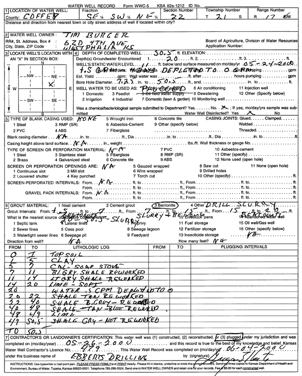
T21S, R17E, Sec. 22 SE SW NE |
Burger, Tim | 50.5 ft. | 11 ft. | .5 gpm. | (unstated)/abandoned | Plugged | 26-May-2000 | Scan | |
|
T21S, R17E, Sec. 22 NE NW SE |
Burger, Tim | 100 ft. | 60 ft. | 4 gpm. | Domestic | Constructed | 06-Sep-2002 | Scan | |
|
T20S, R17E, Sec. 34 NW NW NW NW |
Burkholder, Clement | 140 ft. | 0 gpm. | (unstated)/abandoned | Plugged | 04-Aug-2015 | |||
|
T20S, R17E, Sec. 34 NW NW NW NW |
Burkholder, Clement | 140 ft. | 0 gpm. | (unstated)/abandoned | Constructed | 04-Aug-2015 | |||
|
T21S, R17E, Sec. 3 SE SE SE |
Burkholder, Clement | 58 ft. | Domestic | Plugged | 12-Mar-2025 |
KOLAR |
|||
|
T21S, R17E, Sec. 3 SW SE SE |
Burkholder, Clement | 65 ft. | Domestic | Plugged | 12-Mar-2025 |
KOLAR |
|||
|
T19S, R14E, Sec. 4 NE SE NE SE |
Casey's Retail Company #3919 | 24.5 ft. | .1 ft. | Monitoring well/observation/piezometer | MW 1 | Constructed | 23-Jan-2023 | ||
|
T19S, R14E, Sec. 4 SE SE NE SE |
Casey's Retail Company #3919 | 15.5 ft. | 5 ft. | Monitoring well/observation/piezometer | MW 2 | Constructed | 08-Feb-2023 | ||
|
T19S, R14E, Sec. 4 SE SE NE SE |
Casey's Retail Company #3919 | 15.5 ft. | 3.95 ft. | Monitoring well/observation/piezometer | MW 3 | Constructed | 09-Feb-2023 | ||
|
T19S, R14E, Sec. 4 SE SE NE SE |
Casey's Retail Company #3919 | 15.5 ft. | 4.27 ft. | Monitoring well/observation/piezometer | MW 4 | Constructed | 23-Jan-2023 | ||
|
T19S, R14E, Sec. 4 NE SE NE SE |
Casey's Retail Company #3919 | 15 ft. | 4.35 ft. | Monitoring well/observation/piezometer | MW 5 | Constructed | 10-Feb-2023 | ||
|
T19S, R14E, Sec. 4 NE SE NE SE |
Casey's Retail Company #3919 | 19 ft. | 11.75 ft. | Monitoring well/observation/piezometer | MW 6 | Constructed | 09-Feb-2023 | ||
|
T19S, R14E, Sec. 4 NE SE NE SE |
Casey's Retail Company #3919 | 19.5 ft. | 6.3 ft. | Monitoring well/observation/piezometer | MW 7 | Constructed | 09-Feb-2023 | ||
|
T19S, R14E, Sec. 4 NE SE NE SE |
Casey's Retail Company #3919 | 15.5 ft. | 4.85 ft. | Monitoring well/observation/piezometer | MW 8 | Constructed | 10-Feb-2023 | ||
|
T19S, R14E, Sec. 4 NE SE NE SE |
Casey's Retail Company #3919 | 20.5 ft. | 9.57 ft. | Monitoring well/observation/piezometer | MW 9 | Constructed | 08-Feb-2023 | ||
|
T21S, R15E, Sec. 33 SE SE NW |
Chambers, Bob | 95 ft. | 7.58 ft. | Domestic | Constructed | 02-Jun-1989 | |||
|
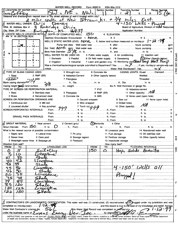
T21S, R15E, Sec. 11 SW NE NW |
Chaney, Chris | 150 ft. | Geothermal, Closed Loop, Vertical | Constructed | 12-Jan-1999 | Scan | |||
|
T19S, R16E, Sec. 11 NE NE |
Chatelain, Irvin | 192 ft. | 135 ft. | 12 gpm. | Domestic | Constructed | 15-Sep-1967 | ||
|
T19S, R14E, Sec. 9 SE SE NE |
City of Lebo | 68 ft. | Public Water Supply | well 1 | Constructed | 01-Mar-1954 | |||
|
T19S, R14E, Sec. 9 SE SE NE |
City of Lebo | 75 ft. | Public Water Supply | well 2 | Constructed | 01-Mar-1954 | |||
|
T19S, R16E, Sec. 14 SE SE SE |
City of Waverly | 233 ft. | 100 ft. | 20 gpm. | Public Water Supply | Constructed | 06-Jun-1980 | ||
|
T19S, R16E, Sec. 14 SW NE NE |
City of Waverly | 195 ft. | 36 ft. | 45 gpm. | Public Water Supply | Constructed | 05-Apr-1983 | ||
|
T19S, R16E, Sec. 24 SW SW |
City of Waverly | 270 ft. | 142 ft. | 20 gpm. | (unstated)/abandoned | Constructed | 02-Dec-1964 | ||
|
T19S, R16E, Sec. 24 SW SW |
City of Waverly | 266 ft. | 130 ft. | 22 gpm. | (unstated)/abandoned | Constructed | 12-Jun-1961 | ||
|
T19S, R16E, Sec. 24 NW NW |
City of Waverly | 280 ft. | 150 ft. | 20 gpm. | (unstated)/abandoned | Constructed | 18-Mar-1969 | ||
|
T21S, R15E, Sec. 22 NW SE SW |
Clark, Lyle | 36 ft. | .5 gpm. | Domestic | Plugged | 20-Aug-2002 | Scan | ||
|
T19S, R16E, Sec. 22 NE |
Clarkson, Jacqueline | 27 ft. | 14 ft. | Domestic, Lawn and Garden | Plugged | 29-Feb-2012 | |||
|
T19S, R15E, Sec. 13 NE NE NE |
Clarkson, Jerry | 180 ft. | 98 ft. | 1.5 gpm. | Domestic | Constructed | 21-Sep-1992 | ||
|
T19S, R14E, Sec. 4 SW NE SE |
Coastal Mart | 20.12 ft. | 3.48 ft. | Monitoring well/observation/piezometer | MW 1 | Plugged | 23-Sep-2005 | ||
|
T19S, R14E, Sec. 4 NE NE SE |
Coastal Mart | 18.34 ft. | 7.68 ft. | Monitoring well/observation/piezometer | MW 2 | Plugged | 23-Sep-2005 | ||
|
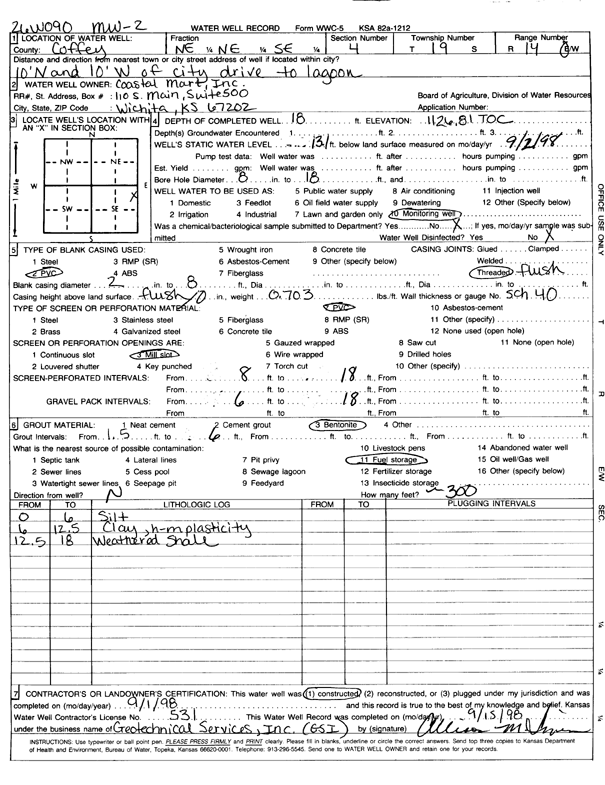
T19S, R14E, Sec. 4 NE NE SE |
Coastal Mart | 18 ft. | 13.1 ft. | Monitoring well/observation/piezometer | MW 2 | Constructed | 01-Sep-1998 | Scan | |
| View page: 1 || 2 || 3 || 4 || 5 || 6 || 7 || 8 || 9 || 10 || Next > | |||||||||