Select location of well to view details.
Click on column heading to sort.
|
|
|
County: Comanche Select location of well to view details. Click on column heading to sort. |
|
|
|
| View page: < Prev || 11 || 12 || 13 || 14 || 15 || 16 || 17 || 18 || 19 || 20 || Next > | |||||||||
| T-R-S | Owner | Well Depth Ascend. Desc. |
Static Water Level Ascend. Desc. |
Est. Yield Ascend. Desc. |
Well Use | Other ID | Action Taken | Completion Date Ascend. Desc. |
Scan? |
|
T32S, R20W, Sec. 8 SW SW SE |
Moore, Gary | 28 ft. | Domestic | Plugged | 23-Jun-1995 | ||||
|
T32S, R20W, Sec. 8 SE NW NW |
Moore, Irene | 38 ft. | Domestic | Plugged | 28-May-1998 | ||||
|
T32S, R20W, Sec. 8 NW SW SE |
Moore, Jim | 18 ft. | Domestic | Plugged | 28-May-1998 | ||||
|
T32S, R20W, Sec. 8 NE NE NW |
Moore, Warren | 65 ft. | 22 ft. | 5 gpm. | Domestic | Constructed | 09-Oct-1986 | ||
|
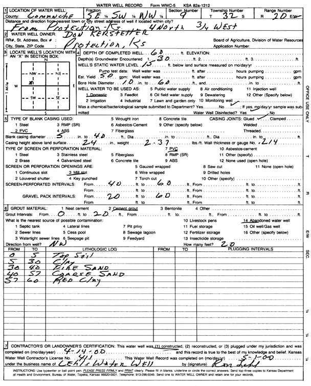
T32S, R20W, Sec. 9 SE SW NW |
Kerstetter, Don | 60 ft. | 15 ft. | 50 gpm. | Domestic | Constructed | 14-Apr-2000 | Scan | |
|
T32S, R20W, Sec. 10 NW SE SE |
Levering, Jeff | 95 ft. | 14 ft. | Domestic | Constructed | 16-Feb-2015 | |||
|
T32S, R20W, Sec. 10 NW NW SE NE |
Reynolds, Jay Don | 56 ft. | 20 ft. | 4 gpm. | Domestic, Livestock | Reconstructed | 13-Feb-2013 |
KOLAR |
|
|
T32S, R20W, Sec. 12 SW NE NW NE |
Jarnigan, Gary | 200 ft. | 111 ft. | 20 gpm. | Domestic, Livestock | Constructed | 23-May-2018 | ||
|
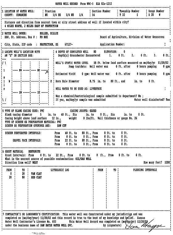
T32S, R20W, Sec. 14 NE SE NE |
Holler, Billie | 80 ft. | 18 ft. | Domestic, Livestock | Constructed | 30-Nov-2002 | Scan | ||
|
T32S, R20W, Sec. 14 SW NW SE |
Wait, Merle | 65 ft. | 40 ft. | 20 gpm. | Domestic | Constructed | 01-Apr-1983 | ||
|
T32S, R20W, Sec. 15 C W2 SE |
Dale, William L. | 44 ft. | 6 ft. | 8 gpm. | Domestic, Livestock | Constructed | 16-Apr-1976 | ||
|
T32S, R20W, Sec. 15 SW SW NE |
Moore, Gary | 31 ft. | 6 ft. | Domestic | Plugged | 23-Jun-1995 | |||
|
T32S, R20W, Sec. 17 NW NW NE |
Moore, Mike | 60 ft. | 23 ft. | 40 gpm. | Domestic | Constructed | 13-Dec-2006 | ||
|
T32S, R20W, Sec. 17 SW SE NW |
Moore, Russell | 26.5 ft. | 16 ft. | Domestic | Constructed | 01-Jun-1978 | |||
|
T32S, R20W, Sec. 17 SW SW NW |
Moore, Warren | 45 ft. | 19 ft. | Domestic | Constructed | 01-Feb-2008 | |||
|
T32S, R20W, Sec. 18 C NW SW |
Loesch, Gene | 45 ft. | 22 ft. | Domestic, Livestock | Constructed | 06-Feb-2013 | |||
|
T32S, R20W, Sec. 18 SW NW NE |
Rich, Larry | 58 ft. | 6 ft. | 150 gpm. | Domestic | Constructed | 11-Dec-2008 | ||
|
T32S, R20W, Sec. 19 SE NW SW |
Herd, John | 115 ft. | 24 ft. | 10 gpm. | Domestic | Constructed | 26-Sep-2005 | ||
|
T32S, R20W, Sec. 19 SE SE NE |
Moore, Jimmy Allen | 62 ft. | 18 ft. | Domestic, Livestock | Constructed | 01-Feb-2008 | |||
|
T32S, R20W, Sec. 19 NE NE NE |
Murfin Drilling Co Inc. | 40 ft. | 4 ft. | 60 gpm. | Oil Field Water Supply | Dodd 1-19 | Constructed | 04-Aug-2008 | |
|
T32S, R20W, Sec. 20 SE SE NW NE |
Herd, John | 35 ft. | 10 ft. | 50 gpm. | Domestic, Livestock | Constructed | 08-May-2014 | ||
|
T32S, R20W, Sec. 21 NE NW NW |
Harvey, Larry | 35 ft. | 10 ft. | 25 gpm. | Domestic | Constructed | 16-Apr-1992 | ||
|
T32S, R20W, Sec. 21 NE NW NW |
Harvey, Larry | 87 ft. | 65 ft. | 3 gpm. | Domestic | Constructed | 10-Apr-1992 | ||
|
T32S, R20W, Sec. 21 SE NE NE |
Riner, Lance | 25 ft. | Domestic | Plugged | 12-Jan-1994 | ||||
|
T32S, R20W, Sec. 22 NE NE NW SW |
Dale, Curt | 56 ft. | 8 ft. | 50 gpm. | Domestic, Livestock | Constructed | 13-Mar-2012 |
KOLAR |
|
|
T32S, R20W, Sec. 24 SW SE SW |
St. Clair, Leigh | 44.5 ft. | 8 ft. | Domestic, Lawn and Garden | garden | Plugged | 11-Sep-2013 | ||
|
T32S, R20W, Sec. 24 SW SE SW |
St. Clair, Leigh | 44 ft. | 8 ft. | Domestic | milk barn | Plugged | 11-Sep-2013 | ||
|
T32S, R20W, Sec. 24 SE SW SW |
St. Clair, Leigh | 125 ft. | 34 ft. | Domestic | Constructed | 24-Feb-2015 | |||
|
T32S, R20W, Sec. 24 SW SE SW |
St. Clair, Leigh | 42.5 ft. | Domestic | wash house | Plugged | 11-Sep-2013 | |||
|
T32S, R20W, Sec. 24 SW SE SW |
St. Clair, Leigh | 38.75 ft. | 2 ft. | Domestic | old house | Plugged | 11-Sep-2013 | ||
|
T32S, R20W, Sec. 25 SW SW NW |
Murphy, Doug | 100 ft. | 40 ft. | 15 gpm. | Domestic | Constructed | 07-Jul-2023 |
KOLAR |
|
|
T32S, R20W, Sec. 25 SW NE NE |
Murphy, Tom | 65 ft. | 25 ft. | Domestic | Constructed | 28-Oct-1981 | |||
|
T32S, R20W, Sec. 25 SE SE NE NE |
Rich, Geraldine I. | 100 ft. | 27 ft. | 20 gpm. | Domestic, Livestock | Constructed | 29-Sep-2016 |
KOLAR |
|
|
T32S, R20W, Sec. 25 C SE NW |
Wheatstate Drilling/Lee St. Clair | 65 ft. | 30 ft. | Oil Field Water Supply | Constructed | 09-Feb-1984 | |||
|
T32S, R20W, Sec. 26 SW NE SW |
Dale, Bill | 50 ft. | 20 ft. | 20 gpm. | Domestic | Constructed | 03-Feb-1991 | ||
|
T32S, R20W, Sec. 26 C NW |
Dale, Bill | 150 ft. | 35 ft. | 1150 gpm. | Irrigation | Constructed | 01-Apr-1976 | ||
|
T32S, R20W, Sec. 26 SE SE NE |
Dale, William | 57 ft. | 18 ft. | 60 gpm. | Domestic | Constructed | 18-Feb-1999 | ||
|
T32S, R20W, Sec. 26 N2 NW |
Dale, William L. | 49 ft. | 17 ft. | 10 gpm. | Domestic | Constructed | 25-Oct-1979 | ||
|
T32S, R20W, Sec. 27 C SE NW |
Aldebaron Drilling Co. | 60 ft. | 7 ft. | 100 gpm. | Oil Field Water Supply | Peterson 1 | Constructed | 29-Jun-1984 | |
|
T32S, R20W, Sec. 27 SE NW SE |
Murphy, Pat | 129 ft. | 4.5 ft. | 1200 gpm. | Irrigation | Constructed | 09-Jun-1975 | ||
|
T32S, R20W, Sec. 27 SW NE SW |
Peterson, Charles | 20 ft. | 4 ft. | Domestic | Plugged | 23-Jun-1995 | |||
|
T32S, R20W, Sec. 27 C N2 NW |
Peterson, Charles | 91 ft. | 16 ft. | 1000 gpm. | Irrigation | Well 1 | Constructed | 20-Mar-1976 | |
|
T32S, R20W, Sec. 27 SE SW SW |
Peterson, Charles | 58 ft. | 15 ft. | 100 gpm. | Domestic | Constructed | 20-May-1991 | ||
|
T32S, R20W, Sec. 27 NE NW SE |
Peterson, Charles | 20 ft. | 12 ft. | Feedlot | Plugged | 21-Oct-1993 | |||
|
T32S, R20W, Sec. 27 NW NE SE |
Peterson, Charles | 15 ft. | Feedlot | Plugged | 21-Oct-1993 | ||||
|
T32S, R20W, Sec. 28 NE NW NE |
Alfono, Pete | 60 ft. | 11 ft. | 50 gpm. | Domestic, Livestock | Constructed | 13-Mar-2024 |
KOLAR |
|
|
T32S, R20W, Sec. 28 NW SW SW |
Clarence Harden Estate | 25 ft. | 13 ft. | 4 gpm. | Domestic, Livestock | Constructed | 29-Oct-1979 | ||
|
T32S, R20W, Sec. 28 NW NW SE NE |
Fellers, Tom | 48 ft. | 12 ft. | 50 gpm. | Domestic | Constructed | 05-Mar-2013 |
KOLAR |
|
|
T32S, R20W, Sec. 28 NW SW SW |
Herd, H.J. | 66 ft. | 10 ft. | 10 gpm. | Domestic, Livestock | Constructed | 25-Sep-1996 | ||
|
T32S, R20W, Sec. 28 NW SE SW |
Herd, H.J. | 16 ft. | 10 ft. | Domestic, Livestock | Plugged | 25-Sep-1996 | |||
| View page: < Prev || 11 || 12 || 13 || 14 || 15 || 16 || 17 || 18 || 19 || 20 || Next > | |||||||||