Select location of well to view details.
Click on column heading to sort.
|
|
|
County: Comanche Select location of well to view details. Click on column heading to sort. |
|
|
|
| View page: 1 || 2 || 3 || 4 || 5 || 6 || 7 || 8 || 9 || 10 || Next > | |||||||||
| T-R-S | Owner | Well Depth Ascend. Desc. |
Static Water Level Ascend. Desc. |
Est. Yield Ascend. Desc. |
Well Use | Other ID | Action Taken | Completion Date Ascend. Desc. |
Scan? |
|
T31S, R18W, Sec. 5 NE NE SE |
Red Tiger Drilling/Dan Robinson | 245 ft. | 90 ft. | 60 gpm. | Oil Field Water Supply | Robinson 1-5 | Constructed | 26-May-1984 | |
|
T31S, R18W, Sec. 5 NE NE SE |
Red Tiger Drilling/Dan Robinson | 245 ft. | 95 ft. | Oil Field Water Supply | Robinson 1-5 | Plugged | 11-Jun-1984 | ||
|
T31S, R18W, Sec. 5 NW SW NE |
Unruh, Curtis | 153 ft. | 40 ft. | Domestic | Plugged | 23-Jun-1995 | |||
|
T31S, R18W, Sec. 5 NE SE NE |
Xplor Drilling Co. | 140 ft. | 100 ft. | 50 gpm. | Oil Field Water Supply | Constructed | 03-Apr-1981 | ||
|
T31S, R18W, Sec. 5 NW NW SW |
Xplor Drilling Co. | 175 ft. | 105 ft. | 80 gpm. | Oil Field Water Supply | Constructed | 26-Mar-1981 | ||
|
T31S, R18W, Sec. 6 NE SE SW |
Abercrombie Drilling/H.P. Timmons | 242 ft. | 140 ft. | 100 gpm. | Oil Field Water Supply | Timmons 1 | Constructed | 11-Sep-1989 | |
|
T31S, R18W, Sec. 6 NE NE NE |
Burkhall, Carl | 125 ft. | 70 ft. | 15 gpm. | Domestic | Constructed | 15-Jun-1995 | ||
|
T31S, R18W, Sec. 7 SE NW SW SW |
Clayton Sherman Family Trust | 140 ft. | 71 ft. | 20 gpm. | Domestic | Constructed | 19-Aug-2020 |
KOLAR |
|
|
T31S, R18W, Sec. 7 C SE SW |
H-30 Drilling Inc./Bill Sherman | 293 ft. | 160 ft. | 60 gpm. | Oil Field Water Supply | Sherman 1 | Constructed | 01-Sep-1988 | |
|
T31S, R18W, Sec. 7 C SE SW |
H-30 Drilling Inc./Bill Sherman | 193 ft. | 160 ft. | 60 gpm. | Oil Field Water Supply | Sherman 1 | Plugged | 14-Sep-1988 | |
|
T31S, R18W, Sec. 7 C SE |
Lobo Drilling Co./Leo Sherman | 275 ft. | 120 ft. | 100 gpm. | Oil Field Water Supply | Constructed | 21-Aug-1989 | ||
|
T31S, R18W, Sec. 8 NW NW SW |
Thompson, Don | 173 ft. | 115 ft. | 100 gpm. | Domestic | Constructed | 31-Jan-1997 | ||
|
T31S, R18W, Sec. 8 NW NW SW |
Thompson, Don | 145 ft. | 110 ft. | Domestic | Plugged | 31-Jan-1997 | |||
|
T31S, R18W, Sec. 8 NW NW SW |
Thompson, Don | 100 ft. | Domestic | Plugged | 31-Jan-1997 | ||||
|
T31S, R18W, Sec. 8 C SE SE |
White and Ellis Drilling | 160 ft. | 90 ft. | Oil Field Water Supply | Constructed | 29-Jun-1992 | |||
|
T31S, R18W, Sec. 9 NW SE SW |
Hummon Corp. | 167 ft. | 80 ft. | Oil Field Water Supply | Constructed | 19-Feb-1994 | |||
|
T31S, R18W, Sec. 12 C NE NE |
Abercrombie Drilling | 140 ft. | 36 ft. | 60 gpm. | Oil Field Water Supply | Constructed | 26-Jul-1980 | ||
|
T31S, R18W, Sec. 12 C NE SE |
D. R. Lauck Oil Co. | 170 ft. | 68 ft. | Oil Field Water Supply | Constructed | 19-Oct-1978 | |||
|
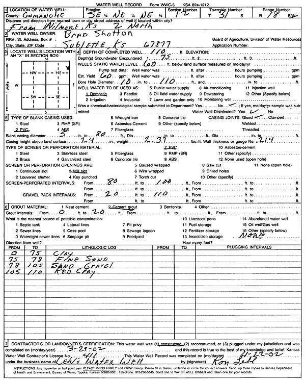
T31S, R18W, Sec. 12 SE NE NE |
Shotton, Brad | 110 ft. | 60 ft. | 60 gpm. | Domestic | Constructed | 29-Mar-2002 | Scan | |
|
T31S, R18W, Sec. 13 C SW NW |
Aldebaron Drilling Co. | 80 ft. | 9 ft. | 80 gpm. | Oil Field Water Supply | Pyle 1 | Constructed | 20-Jun-1984 | |
|
T31S, R18W, Sec. 13 SW NW SW |
Unruh, John | 75 ft. | 15 ft. | 25 gpm. | Domestic | Constructed | 14-Feb-2025 |
KOLAR |
|
|
T31S, R18W, Sec. 16 C NE SE |
Pickrell Drilling/Gene Uhl | 240 ft. | 105 ft. | Oil Field Water Supply | Constructed | 25-Feb-1983 | |||
|
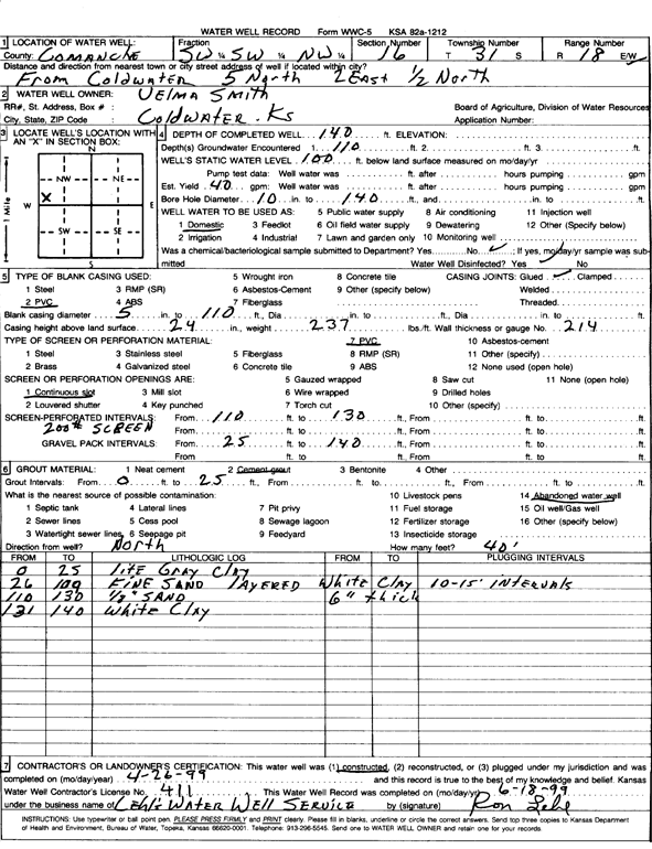
T31S, R18W, Sec. 16 SW SW NW |
Smith, Velma | 140 ft. | 100 ft. | 40 gpm. | Domestic | Constructed | 26-Apr-1999 | Scan | |
|
T31S, R18W, Sec. 17 NW NW NW |
Lobo Drilling Co./Harold Swarner | 215 ft. | 135 ft. | 80 gpm. | Oil Field Water Supply | Constructed | 31-Oct-1989 | ||
|
T31S, R18W, Sec. 17 NW NW SW |
Trans-Pac Drilling | 179 ft. | 127 ft. | Oil Field Water Supply | Constructed | 05-Jan-1991 | |||
|
T31S, R18W, Sec. 18 C NE NW |
H-30 Drilling Inc./Bill Miller | 275 ft. | 160 ft. | 60 gpm. | Oil Field Water Supply | Miller 1 | Constructed | 12-Aug-1988 | |
|
T31S, R18W, Sec. 18 C NE NW |
H-30 Drilling Inc./Bill Miller | 275 ft. | 160 ft. | 60 gpm. | Oil Field Water Supply | Miller 1 | Plugged | 01-Sep-1988 | |
|
T31S, R18W, Sec. 18 NE NW SW |
Vance, Jack | 120 ft. | 10 gpm. | Domestic, Livestock | Constructed | 16-May-1981 | |||
|
T31S, R18W, Sec. 19 SW NW NE |
Alexander, Ella | 100 ft. | 90 ft. | Domestic | Plugged | 27-May-1997 | |||
|
T31S, R18W, Sec. 19 C NW |
Lobo Drilling Co./United Methodist Church | 270 ft. | 140 ft. | 100 gpm. | Oil Field Water Supply | Constructed | 14-Jul-1989 | ||
|
T31S, R18W, Sec. 19 SW SW NE |
Lohrding, Arlie | 120 ft. | 80 ft. | 20 gpm. | Domestic, Livestock | Constructed | 30-Sep-1987 | ||
|
T31S, R18W, Sec. 19 NE NW SE |
Yost, Harlen | 100 ft. | 50 ft. | Domestic, Livestock | Constructed | 19-Apr-1984 | |||
|
T31S, R18W, Sec. 21 NE NE NE |
Boisseau, Roy | 260 ft. | 135 ft. | 100 gpm. | Domestic, Livestock | Constructed | 09-Dec-1982 | ||
|
T31S, R18W, Sec. 21 NE SW SW |
Proctor, Betty Jean | 310 ft. | 106 ft. | 1600 gpm. | Irrigation | Constructed | 31-Dec-1977 | ||
|
T31S, R18W, Sec. 21 SW SW SE |
Reeder Oper LLC | 300 ft. | 124 ft. | 100 gpm. | Oil Field Water Supply | John D Wilbanks 1-21 | Constructed | 30-Jun-2011 | |
|
T31S, R18W, Sec. 21 SE SW SE |
Will Banks Family Trust | 166 ft. | 124 ft. | 40 gpm. | Domestic, Livestock | Constructed | 17-Nov-2022 | ||
|
T31S, R18W, Sec. 23 NW NW SE |
Oil Producers of Kansas | 250 ft. | 60 ft. | 120 gpm. | Oil Field Water Supply | Gray 1-23 | Constructed | 11-Oct-2011 | |
|
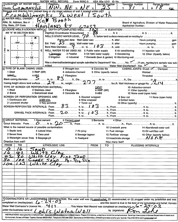
T31S, R18W, Sec. 25 NW NE NE |
Booth, Ron | 103 ft. | 70 ft. | 25 gpm. | Domestic | Constructed | 24-Jun-2003 | Scan | |
|
T31S, R18W, Sec. 25 SW SE NE |
Burkhall, Roy | 141 ft. | 60 ft. | 10 gpm. | Domestic | Constructed | 07-Jun-1975 | ||
|
T31S, R18W, Sec. 25 C SW NE |
Cudney, Rex | 222 ft. | 100 ft. | Oil Field Water Supply | Brandener 1 | Plugged | 03-Jul-1983 | ||
|
T31S, R18W, Sec. 25 C SW NE |
Red Tiger Drilling/Frank Brandener | 217 ft. | 125 ft. | 60 gpm. | Oil Field Water Supply | Brandener 1 | Constructed | 16-Jun-1983 | |
|
T31S, R18W, Sec. 25 C S2 |
Unruh, Alton | 267 ft. | 100 ft. | 900 gpm. | Irrigation | Well 1 | Constructed | 07-Feb-1976 | |
|
T31S, R18W, Sec. 25 SW SW SW |
Unruh, Alton | 220 ft. | 82 ft. | 12 gpm. | Domestic, Livestock | Constructed | 03-Dec-1980 | ||
|
T31S, R18W, Sec. 25 NW NE SE |
Unruh, Mike | 147 ft. | 100 ft. | Domestic, Livestock | Constructed | 22-Apr-1976 | |||
|
T31S, R18W, Sec. 26 SW SW NW |
Dale Gray, Robert | 122 ft. | 81 ft. | Domestic, Livestock | Constructed | 13-Feb-2019 | |||
|
T31S, R18W, Sec. 26 C SW |
Turner, Mrs. Lee | 297 ft. | 113.3 ft. | 800 gpm. | Irrigation | Constructed | 18-Jun-1976 | ||
|
T31S, R18W, Sec. 26 SE SE NE |
Xplor Drilling Co. | 120 ft. | 60 ft. | 100 gpm. | Oil Field Water Supply | Constructed | 09-Jul-1976 | ||
|
T31S, R18W, Sec. 27 NW SE SE |
Boisseau, Roy | 260 ft. | 140 ft. | 25 gpm. | Domestic, Livestock | Constructed | 22-Jan-1981 | ||
|
T31S, R18W, Sec. 28 SE SW NW |
Thorton, Roger | 220 ft. | 160 ft. | 75 gpm. | Domestic | Constructed | 27-Feb-1989 | ||
|
T31S, R18W, Sec. 29 SW SE SE |
Boisseau, Roger | 280 ft. | 121 ft. | 100 gpm. | Domestic | Constructed | 14-Sep-2007 | ||
| View page: 1 || 2 || 3 || 4 || 5 || 6 || 7 || 8 || 9 || 10 || Next > | |||||||||