Select location of well to view details.
Click on column heading to sort.
|
|
|
County: Comanche Select location of well to view details. Click on column heading to sort. |
|
|
|
| View page: 1 || 2 || 3 || 4 || 5 || 6 || 7 || 8 || 9 || 10 || Next > | |||||||||
| T-R-S | Owner | Well Depth Ascend. Desc. |
Static Water Level Ascend. Desc. |
Est. Yield Ascend. Desc. |
Well Use | Other ID | Action Taken | Completion Date Ascend. Desc. |
Scan? |
|
T31S, R18W, Sec. 29 C SW |
Boisseau, Roy | 295 ft. | 76 ft. | Irrigation | Constructed | 14-Feb-1975 | |||
|
T31S, R18W, Sec. 29 NW SW NW |
Butler, Don | 125 ft. | 85 ft. | Domestic | Plugged | 27-May-1997 | |||
|
T31S, R18W, Sec. 30 C NW SE |
Hummon Oil Co. | 170 ft. | 72 ft. | Oil Field Water Supply | Yost B 1 | Constructed | 25-Jan-1991 | ||
|
T31S, R18W, Sec. 30 C NW NW |
Ramco Drilling Co. | 243 ft. | 75 ft. | 60 gpm. | Oil Field Water Supply | Yost Farms 2 | Constructed | 09-Dec-1980 | |
|
T31S, R18W, Sec. 30 SE NW NE |
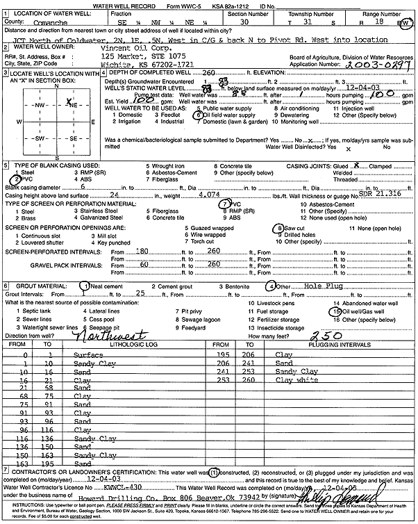
Vincent Oil Corp. | 260 ft. | 83 ft. | 100 gpm. | Oil Field Water Supply | Yost 1-30 | Constructed | 04-Dec-2003 | Scan |
|
T31S, R18W, Sec. 30 C NW |
Yost Farms, Inc. | 267 ft. | 65 ft. | 1500 gpm. | Irrigation | Well 6 | Constructed | 31-Jan-1976 | |
|
T31S, R18W, Sec. 30 C SW |
Yost Farms, Inc. | 264 ft. | 44 ft. | 1500 gpm. | Irrigation | Constructed | 22-Jan-1976 | ||
|
T31S, R18W, Sec. 30 SE SE SE |
Yost, Harlen | 125 ft. | 60 ft. | Domestic, Livestock | Constructed | 27-Apr-1984 | |||
|
T31S, R18W, Sec. 31 SW SW NW |
Pickrell Drilling Co. | 100 ft. | 25 ft. | Oil Field Water Supply | Buhl A 1 | Constructed | 12-Dec-1992 | ||
|
T31S, R18W, Sec. 32 SW NW SE |
Boisseau, Roy | 65 ft. | Domestic, Livestock | Plugged | 01-Nov-1994 | ||||
|
T31S, R18W, Sec. 32 SW NW SE |
Boisseau, Roy | 85 ft. | 80 ft. | Domestic, Livestock | Plugged | 31-Oct-1994 | |||
|
T31S, R18W, Sec. 32 SW NW SE |
Boisseau, Roy | 120 ft. | 85 ft. | 15 gpm. | Domestic, Livestock | Constructed | 22-Oct-1994 | ||
|
T31S, R18W, Sec. 32 NW NW NW |
Lytle, Ron | 275 ft. | 118 ft. | 100 gpm. | Domestic | Constructed | 18-Sep-2007 | ||
|
T31S, R18W, Sec. 33 NW NW NE |
Boisseau, Roy | 160 ft. | 82 ft. | 15 gpm. | Domestic | Constructed | 11-Feb-1987 | ||
|
T31S, R18W, Sec. 33 NE SE NW SW |
Wall, Nathan | 192 ft. | 120 ft. | 35 gpm. | Domestic | Constructed | 18-Sep-2013 |
KOLAR |
|
|
T31S, R18W, Sec. 34 C N2 |
Boisseau, Eldon | 294 ft. | 80 ft. | Irrigation | Well 1 | Constructed | 06-Dec-1975 | ||
|
T31S, R18W, Sec. 34 C SW |
Boisseau, Roy | 224 ft. | 78 ft. | 50 gpm. | Domestic, Livestock | Constructed | 07-Jul-1978 | ||
|
T31S, R18W, Sec. 34 C SW |
Boisseau, Roy | 288 ft. | 109 ft. | 1500 gpm. | Irrigation | Well 4 | Constructed | 26-Jul-1978 | |
|
T31S, R18W, Sec. 34 SE SE SE |
Gray, Robert Dale | 170 ft. | 73 ft. | Domestic, Livestock | Constructed | 01-Oct-2012 | |||
|
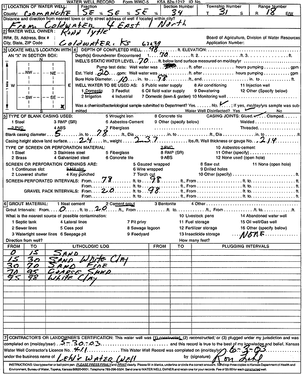
T31S, R18W, Sec. 34 SE SE SE |
Lytle, Ronn | 98 ft. | 70 ft. | 20 gpm. | Domestic | Constructed | 30-May-2003 | Scan | |
|
T31S, R18W, Sec. 35 C NE |
Frank, Floyd | 271 ft. | 80 ft. | Irrigation | Well 1 | Constructed | 31-Jan-1976 | ||
|
T31S, R18W, Sec. 35 SE SE SW |
Turner, Lee | 143 ft. | 73 ft. | Domestic | Constructed | 30-Nov-1988 | |||
|
T31S, R18W, Sec. 35 C SW |
Turner, Mrs. Lee | 266 ft. | 76 ft. | 900 gpm. | Irrigation | Well 2 | Constructed | 21-May-1976 | |
|
T31S, R18W, Sec. 35 N2 NW |
Turner, Mrs. Lee | 266 ft. | 78 ft. | 900 gpm. | Irrigation | Well 4 | Constructed | 19-May-1976 | |
|
T31S, R18W, Sec. 35 C SE |
Turner, Mrs. Lee | 215 ft. | 53 ft. | 800 gpm. | Irrigation | Well 1 | Constructed | 18-May-1976 | |
|
T31S, R18W, Sec. 36 C SE SE |
Allen Drilling | 220 ft. | 105 ft. | Oil Field Water Supply | Constructed | 24-Jul-1987 | |||
|
T31S, R18W, Sec. 36 SE SW SW |
Bowman, Jim | 183 ft. | 97 ft. | 100 gpm. | Domestic, Livestock | Constructed | 11-Dec-2015 | ||
|
T31S, R18W, Sec. 36 C SE NW |
DaMac Drilling Inc. | 215 ft. | 85 ft. | 40 gpm. | Oil Field Water Supply | Constructed | 13-Feb-1976 | ||
|
T31S, R18W, Sec. 36 NW NE NW |
Ramco Drilling Co. | 210 ft. | 110 ft. | 60 gpm. | Oil Field Water Supply | Constructed | 07-Aug-1981 | ||
|
T31S, R19W, Sec. 1 NE SW SW |
Freund, Jarod | 132 ft. | 83 ft. | Domestic | Constructed | 04-Apr-2025 |
KOLAR |
||
|
T31S, R19W, Sec. 2 SE NE NW |
Miller, Darrol | 108 ft. | 60 ft. | 20 gpm. | Domestic | Constructed | 15-Jun-1989 | ||
|
T31S, R19W, Sec. 4 SW NE SW |
Marley, Cecil | 138 ft. | 85 ft. | 25 gpm. | Domestic | Constructed | 16-Jun-1981 | ||
|
T31S, R19W, Sec. 5 SW NW SE NW |
Zielke, LeRoy | 95 ft. | 54 ft. | 85 gpm. | Domestic, Livestock | Constructed | 25-Feb-2014 |
KOLAR |
|
|
T31S, R19W, Sec. 7 NW SW NE |
Lohrding, Arlie | 105 ft. | 80 ft. | Domestic | Plugged | 28-May-1997 | |||
|
T31S, R19W, Sec. 7 SE NE NE |
Magellan Ammonia Pipeline, LP | 27 ft. | Monitoring well/observation/piezometer | MW 3 | Constructed | 28-Nov-2012 | |||
|
T31S, R19W, Sec. 7 SE NE NE |
Magellan Ammonia Pipeline, LP | 45 ft. | Monitoring well/observation/piezometer | MW 5 | Constructed | 28-Nov-2012 | |||
|
T31S, R19W, Sec. 7 SE NE NE |
Magellan Ammonia Pipeline, LP | 27 ft. | Monitoring well/observation/piezometer | MW 1 | Constructed | 27-Nov-2012 | |||
|
T31S, R19W, Sec. 7 SE NE NE |
Magellan Ammonia Pipeline, LP | 40 ft. | Monitoring well/observation/piezometer | MW 4 | Constructed | 28-Nov-2012 | |||
|
T31S, R19W, Sec. 7 SE NE NE |
Magellan Ammonia Pipeline, LP | 26 ft. | Monitoring well/observation/piezometer | MW 2 | Constructed | 27-Nov-2012 | |||
|
T31S, R19W, Sec. 7 SE NE NE |
Magellan Ammonia Pipeline, LP | 25 ft. | Monitoring well/observation/piezometer | MW 6 | Constructed | 29-Nov-2012 | |||
|
T31S, R19W, Sec. 7 SE NE NE |
Magellan Ammonia Pipeline, LP | 30 ft. | Monitoring well/observation/piezometer | MW 7 | Constructed | 29-Nov-2012 | |||
|
T31S, R19W, Sec. 7 SE NE NE |
Magellan Midstream Partners, LP | 30 ft. | 28.01 ft. | Monitoring well/observation/piezometer | MW 10 | Constructed | 26-Nov-2013 | ||
|
T31S, R19W, Sec. 7 SE NE NE |
Magellan Midstream Partners, LP | 50 ft. | 42.79 ft. | Monitoring well/observation/piezometer | MW 8 | Constructed | 26-Nov-2013 | ||
|
T31S, R19W, Sec. 7 NW SE NE |
Magellan Midstream Partners, LP | 39 ft. | 35.52 ft. | Monitoring well/observation/piezometer | MW 11 | Constructed | 18-Mar-2014 | ||
|
T31S, R19W, Sec. 7 NE SW NE |
Magellan Midstream Partners, LP | 26 ft. | 13.8 ft. | Monitoring well/observation/piezometer | MW 12 | Constructed | 18-Mar-2014 | ||
|
T31S, R19W, Sec. 7 SE SE NW |
Magellan Midstream Partners, LP | 28.5 ft. | 24.82 ft. | Monitoring well/observation/piezometer | MW 13 | Constructed | 19-Mar-2014 | ||
|
T31S, R19W, Sec. 7 NW NW SW NE |
Magellan Midstream Partners, LP | 30 ft. | 21 ft. | Monitoring well/observation/piezometer | MW 15 | Constructed | 10-May-2017 |
KOLAR |
|
|
T31S, R19W, Sec. 7 NW SW SW NE |
Magellan Midstream Partners, LP | 30 ft. | 26 ft. | Monitoring well/observation/piezometer | MW 14 | Constructed | 10-May-2017 |
KOLAR |
|
|
T31S, R19W, Sec. 7 SE NE NE |
Magellan Midstream Partners, LP | 30 ft. | 22.5 ft. | Monitoring well/observation/piezometer | MW 9 | Constructed | 26-Nov-2013 | ||
|
T31S, R19W, Sec. 8 C SE NE |
Duke Drilling Co./Jack White | 250 ft. | 110 ft. | 90 gpm. | Oil Field Water Supply | Constructed | 16-Mar-1990 | ||
| View page: 1 || 2 || 3 || 4 || 5 || 6 || 7 || 8 || 9 || 10 || Next > | |||||||||