Select location of well to view details.
Click on column heading to sort.
|
|
|
County: Comanche Select location of well to view details. Click on column heading to sort. |
|
|
|
| View page: 1 || 2 || 3 || 4 || 5 || 6 || 7 || 8 || 9 || 10 || Next > | |||||||||
| T-R-S | Owner | Well Depth Ascend. Desc. |
Static Water Level Ascend. Desc. |
Est. Yield Ascend. Desc. |
Well Use | Other ID | Action Taken | Completion Date Ascend. Desc. |
Scan? |
|
T31S, R20W, Sec. 7 SW SW SW SW |
Huck Ranch Livestock | 111 ft. | 30 ft. | Domestic | Constructed | 04-Oct-2012 | |||
|
T31S, R20W, Sec. 8 SW SW NW |
Huck, Bob | 146 ft. | 88.2 ft. | Domestic | Constructed | 15-May-2006 | |||
|
T31S, R20W, Sec. 9 SE SW NE |
Huck Ranch | 100 ft. | 22 ft. | Irrigation | Constructed | 21-May-1990 | |||
|
T31S, R20W, Sec. 9 SE SW NE |
Huck Ranch | 98 ft. | 18 ft. | Irrigation | Plugged | 01-May-1990 | |||
|
T31S, R20W, Sec. 11 NE NE SW |
Lohrding, Arlie | 68 ft. | 65 ft. | Domestic | Plugged | 28-May-1997 | |||
|
T31S, R20W, Sec. 11 SE NE SW |
Lohrding, Arlie | 90 ft. | 60 ft. | 20 gpm. | Domestic | Constructed | 11-Jun-1993 | ||
|
T31S, R20W, Sec. 12 NE SE NE |
Lohrding, Arlie | 95 ft. | 60 ft. | 20 gpm. | Domestic | Constructed | 08-Jun-1993 | ||
|
T31S, R20W, Sec. 13 SE NW NE |
Lohrding, Arlie | 95 ft. | 45 ft. | 20 gpm. | Domestic | Constructed | 05-Apr-1991 | ||
|
T31S, R20W, Sec. 14 SW SE SE |
Lohrding, Arlie | 24 ft. | Domestic | Plugged | 29-May-1996 | ||||
|
T31S, R20W, Sec. 14 NW SE NW SE |
Magellan Ammonia Pipeline, LP | 32 ft. | Monitoring well/observation/piezometer | MW 6 | Constructed | 20-Sep-2013 | |||
|
T31S, R20W, Sec. 14 NW SE NW SE |
Magellan Ammonia Pipeline, LP | 32 ft. | Monitoring well/observation/piezometer | MW 5 | Constructed | 20-Sep-2013 | |||
|
T31S, R20W, Sec. 14 NE SW SE |
Magellan Ammonia Pipeline, LP | 32 ft. | Monitoring well/observation/piezometer | MW 4 | Constructed | 26-Nov-2012 | |||
|
T31S, R20W, Sec. 14 SW SE NW SE |
Magellan Midstream Partners, LP | 32 ft. | 24.9 ft. | Monitoring well/observation/piezometer | MW 5 | Plugged | 21-Sep-2021 |
KOLAR |
|
|
T31S, R20W, Sec. 14 NW SE NW SE |
Magellan Midstream Partners, LP | 32 ft. | 26.5 ft. | Monitoring well/observation/piezometer | MW 4 | Plugged | 21-Sep-2021 |
KOLAR |
|
|
T31S, R20W, Sec. 14 SW SE NW SE |
Magellan Midstream Partners, LP | 32 ft. | 26 ft. | Monitoring well/observation/piezometer | MW 3 | Plugged | 21-Sep-2021 |
KOLAR |
|
|
T31S, R20W, Sec. 14 SW SE NW SE |
Magellan Midstream Partners, LP | 32 ft. | 25.5 ft. | Monitoring well/observation/piezometer | MW 2 | Plugged | 21-Sep-2021 |
KOLAR |
|
|
T31S, R20W, Sec. 14 NW SE NW SE |
Magellan Midstream Partners, LP | 32 ft. | 25.1 ft. | Monitoring well/observation/piezometer | MW 1 | Plugged | 21-Sep-2021 |
KOLAR |
|
|
T31S, R20W, Sec. 14 SW SE NW SE |
Magellan Midstream Partners, LP | 32 ft. | 26.6 ft. | Monitoring well/observation/piezometer | MW 6 | Plugged | 21-Sep-2021 |
KOLAR |
|
|
T31S, R20W, Sec. 14 NW SE SW |
Magellan Midstream Partners, LP | 32 ft. | Monitoring well/observation/piezometer | Constructed | 17-Jan-2008 | ||||
|
T31S, R20W, Sec. 14 NW SE SW |
Magellan Midstream Partners, LP | 32 ft. | Monitoring well/observation/piezometer | Constructed | 17-Jan-2008 | ||||
|
T31S, R20W, Sec. 14 NW SE SW |
Magellan Midstream Partners, LP | 32 ft. | Monitoring well/observation/piezometer | Constructed | 17-Jan-2008 | ||||
|
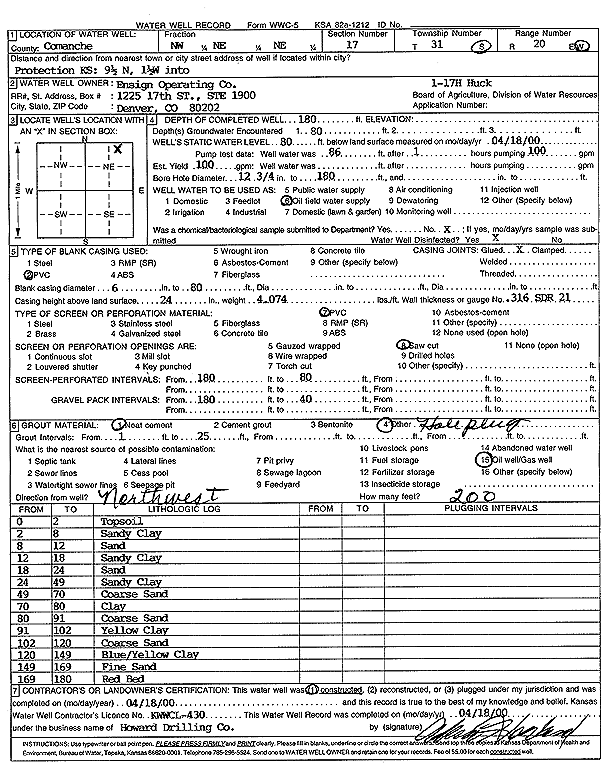
T31S, R20W, Sec. 17 NW NE NE |
Ensign Operating Co. | 180 ft. | 80 ft. | 100 gpm. | Oil Field Water Supply | Huck 1-17H | Constructed | 18-Apr-2000 | Scan |
|
T31S, R20W, Sec. 21 SW SE SE SW |
McLaughlin, Grace | 120 ft. | 54 ft. | 10 gpm. | Domestic, Livestock | Constructed | 23-Sep-2011 |
KOLAR |
|
|
T31S, R20W, Sec. 22 NE NE NE |
Lohrding, Arlie | 48 ft. | 27 ft. | Domestic | Plugged | 29-May-1996 | |||
|
T31S, R20W, Sec. 25 SE NE NW |
Kerstetter, Judy | 50 ft. | 14 ft. | Domestic, Livestock | Constructed | 27-Nov-2012 | |||
|
T31S, R20W, Sec. 28 SE SE NW |
Edmonston, Myron | 91 ft. | 45 ft. | Domestic, Livestock | Constructed | 17-Apr-2020 | |||
|
T31S, R20W, Sec. 29 SE SW NE SE |
Edmonston, Myron | 140 ft. | 50 ft. | 7 gpm. | Domestic | Constructed | 02-Oct-2009 | ||
|
T31S, R20W, Sec. 29 SE SE NE |
Sangster, Robert | 48 ft. | 18 ft. | 20 gpm. | Domestic | Constructed | 26-Jun-1981 | ||
|
T31S, R20W, Sec. 32 NW SW NW |
Harvey Brothers | 130 ft. | 36 ft. | Domestic, Livestock | Constructed | 20-Nov-2025 |
KOLAR |
||
|
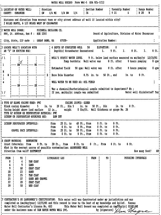
T31S, R20W, Sec. 36 SW NE NW |
Pickrell Drilling Co. | 50 ft. | 9 ft. | 50 gpm. | Oil Field Water Supply | Constructed | 15-Dec-2001 | Scan | |
|
T32S, R16W, Sec. 4 SE NE NW |
Schuette Trust | 30 ft. | 6 ft. | 160 gpm. | Irrigation | Constructed | 10-May-1984 | ||
|
T32S, R16W, Sec. 4 SE NE NW |
Schuette Trust | 30 ft. | 6 ft. | 160 gpm. | Irrigation | Constructed | 08-May-1984 | ||
|
T32S, R16W, Sec. 4 SE NE NW |
Schuette Trust | 30 ft. | 6 ft. | 160 gpm. | Irrigation | Constructed | 09-May-1984 | ||
|
T32S, R16W, Sec. 4 SE NE NW |
Schuette Trust | 30 ft. | 6 ft. | 160 gpm. | Irrigation | Constructed | 12-May-1984 | ||
|
T32S, R16W, Sec. 6 SW NE NW SW |
Uhl, Andy | 159 ft. | 120 ft. | 20 gpm. | Domestic, Livestock | Constructed | 18-Sep-2014 |
KOLAR |
|
|
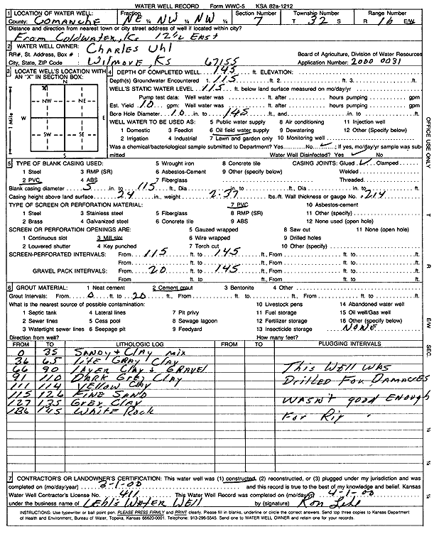
T32S, R16W, Sec. 7 NE NW NW |
Uhl, Charles | 145 ft. | 115 ft. | 10 gpm. | Oil Field Water Supply | Constructed | 01-Mar-2000 | Scan | |
|
T32S, R16W, Sec. 7 S2 NE SE |
York, Pauline | 55 ft. | 37 ft. | 10 gpm. | Domestic, Livestock | Constructed | 20-Oct-2013 | ||
|
T32S, R16W, Sec. 7 SE NW SE |
York, Pauline | 82 ft. | 64.5 ft. | 10 gpm. | Domestic, Livestock | Constructed | 03-Oct-2018 | ||
|
T32S, R16W, Sec. 8 SW NE NE |
Uhl, Tony | 31 ft. | 14 ft. | 5 gpm. | Domestic | Constructed | 11-Oct-1979 | ||
|
T32S, R16W, Sec. 9 NW NW NE NW |
Huck, Bob | 34 ft. | 22 ft. | 10 gpm. | Domestic, Livestock | Constructed | 06-May-2015 |
KOLAR |
|
|
T32S, R16W, Sec. 9 NW SW NW |
Mule Creek Ranch | 145 ft. | 47 ft. | Domestic | Constructed | 07-Mar-2005 | |||
|
T32S, R16W, Sec. 11 SW SW SW |
Einsel, Ralph | 34 ft. | 8 ft. | 12 gpm. | Domestic | Constructed | 03-Aug-1981 | ||
|
T32S, R16W, Sec. 17 SW SW NW |
Mule Creek Ranch | 56 ft. | 15 ft. | 5 gpm. | Domestic | Well 1 | Constructed | 21-Sep-2011 | |
|
T32S, R16W, Sec. 17 SW SW SW |
Mule Creek Ranch | 78 ft. | 30 ft. | 5 gpm. | Domestic | Well 2 | Constructed | 21-Sep-2011 | |
|
T32S, R16W, Sec. 19 NE SE NW |
Thomison, Ellen | 103 ft. | 68 ft. | 200 gpm. | Domestic | Constructed | 22-Sep-1995 | ||
|
T32S, R16W, Sec. 20 SW NW SE |
Ballout, Lisa | 138 ft. | 46 ft. | 10 gpm. | Domestic, Livestock | Constructed | 29-Oct-2012 | ||
|
T32S, R16W, Sec. 20 SE SE NE |
Donald York Estate | 80 ft. | 49 ft. | 5 gpm. | Domestic | Constructed | 25-Apr-1985 | ||
|
T32S, R16W, Sec. 25 SW SE SE |
Spencer, Rob | 98 ft. | 8 ft. | 60 gpm. | Domestic, Livestock | Constructed | 29-Oct-2025 | ||
|
T32S, R16W, Sec. 28 NW SE NE |
Brass Ranch | 84 ft. | 71 ft. | Domestic, Livestock | Constructed | 19-Nov-2024 |
KOLAR |
||
|
T32S, R16W, Sec. 31 SW SW NE |
Summers, Jim | 46 ft. | 23 ft. | 10 gpm. | Domestic | Constructed | 25-Aug-1978 | ||
| View page: 1 || 2 || 3 || 4 || 5 || 6 || 7 || 8 || 9 || 10 || Next > | |||||||||