Select location of well to view details.
Click on column heading to sort.
|
|
|
County: Cowley Select location of well to view details. Click on column heading to sort. |
|
|
|
| View page: < Prev || 21 || 22 || 23 || 24 || 25 || 26 || 27 || 28 || 29 || 30 || Next > | |||||||||
| T-R-S | Owner | Well Depth Ascend. Desc. |
Static Water Level Ascend. Desc. |
Est. Yield Ascend. Desc. |
Well Use | Other ID | Action Taken | Completion Date Ascend. Desc. |
Scan? |
|
T33S, R4E, Sec. 7 NE NW NW |
Guffy, Shawn | 65 ft. | 39 ft. | Domestic | Constructed | 06-Feb-2013 | |||
|
T33S, R4E, Sec. 7 SW SE NW |
Priest, Lester | 60 ft. | 36 ft. | 290 gpm. | Irrigation | Constructed | 25-Jun-1982 | ||
|
T33S, R4E, Sec. 7 SW SE NW |
Priest, Lester J. | 57 ft. | 35 ft. | 550 gpm. | Irrigation | Well 2 | Constructed | 12-May-1977 | |
|
T33S, R4E, Sec. 7 SW SE |
Simmons, Bob D. | 55 ft. | 5 ft. | Domestic | Constructed | 28-Jun-1995 | |||
|
T33S, R4E, Sec. 7 SW SW SW |
Yzquierdo, Sarah | 55 ft. | 20 ft. | Domestic | Constructed | 16-Oct-2025 |
KOLAR |
||
|
T33S, R4E, Sec. 8 NW NW NE |
Herric, M. D. | 74 ft. | 32 ft. | Domestic | Constructed | 11-May-1982 | |||
|
T33S, R4E, Sec. 9 NW SW SE |
May, Marion | 80 ft. | 28.5 ft. | 55 gpm. | Domestic | Constructed | 14-Oct-1988 | ||
|
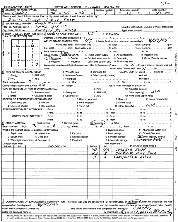
T33S, R4E, Sec. 9 SE SE SE |
Russell, Ralph | 85 ft. | 47 ft. | Domestic | Plugged | 27-Aug-1999 | Scan | ||
|
T33S, R4E, Sec. 14 NW SW NE |
McCollum, Barton | 46 ft. | 35 ft. | 12 gpm. | Domestic | Constructed | 10-Nov-1980 | ||
|
T33S, R4E, Sec. 15 NW SW SW |
Heffron, Ronal | 100 ft. | 69 ft. | 15 gpm. | Domestic | Constructed | 28-Sep-1979 | ||
|
T33S, R4E, Sec. 15 SW NE SW |
Pearce, Derrel G. | 157 ft. | 80 ft. | 5 gpm. | Domestic | Constructed | 15-Jun-1991 | ||
|
T33S, R4E, Sec. 15 SW SE SW |
Shields, D. R. | 83 ft. | 50 ft. | 3 gpm. | Domestic | Constructed | 23-Nov-1977 | ||
|
T33S, R4E, Sec. 16 SE SE NW |
Scott, J. F. | 100 ft. | 45 ft. | 1.75 gpm. | Domestic | Constructed | 14-Sep-1979 | ||
|
T33S, R4E, Sec. 17 SW SW SW |
Beach, Gerald | 52 ft. | 25.5 ft. | 62.5 gpm. | Domestic | Constructed | 26-Oct-1987 | ||
|
T33S, R4E, Sec. 18 NE NE SW |
Cities of Arkansas City and Winfield | 45 ft. | 150 gpm. | Public Water Supply | Well 10 | Constructed | 22-Apr-1986 | ||
|
T33S, R4E, Sec. 18 NW NW NW |
Cities of Arkansas City and Winfield | 35 ft. | 18 ft. | Domestic | Plugged | 08-Sep-1988 | |||
|
T33S, R4E, Sec. 18 NW NE SE |
Cities of Arkansas City and Winfield | 51 ft. | 34 ft. | 200 gpm. | Public Water Supply | Constructed | 07-Jun-1991 | ||
|
T33S, R4E, Sec. 18 NW NE SE |
Cities of Arkansas City and Winfield | 51 ft. | 33 ft. | 150 gpm. | Public Water Supply | Well 13 | Constructed | 20-Sep-1989 | |
|
T33S, R4E, Sec. 18 NW SW SE |
General Electric Co. | 45 ft. | 17.2 ft. | Monitoring well/observation/piezometer | DM 13 | Constructed | 24-May-1984 | Scan | |
|
T33S, R4E, Sec. 18 SE NE SW |
General Electric Co. | 23 ft. | 14.75 ft. | Monitoring well/observation/piezometer | Constructed | 23-May-1984 | Scan | ||
|
T33S, R4E, Sec. 18 NE NE SW |
General Electric Co. | 26 ft. | 16.65 ft. | Monitoring well/observation/piezometer | DM 28 | Constructed | 09-May-1985 | ||
|
T33S, R4E, Sec. 18 SE NE SW |
General Electric Co. | 23 ft. | 16.52 ft. | Monitoring well/observation/piezometer | DM 18 | Constructed | 02-May-1985 | ||
|
T33S, R4E, Sec. 18 NE SE SW |
General Electric Co. | 25 ft. | 16.6 ft. | Monitoring well/observation/piezometer | DM 17 | Constructed | 01-May-1985 | ||
|
T33S, R4E, Sec. 18 NW SE SE |
General Electric Co. | 30 ft. | 20.84 ft. | Monitoring well/observation/piezometer | DM 27 | Constructed | 09-May-1985 | ||
|
T33S, R4E, Sec. 18 NW SW SE |
General Electric Co. | 30 ft. | 17.59 ft. | Monitoring well/observation/piezometer | DM 14 | Constructed | 24-May-1984 | Scan | |
|
T33S, R4E, Sec. 18 SW SE SW |
General Electric Co. | 21 ft. | 14.79 ft. | Monitoring well/observation/piezometer | DM 20 | Constructed | 06-May-1985 | ||
|
T33S, R4E, Sec. 18 SE NE SW |
General Electric Co. | 25 ft. | 14.17 ft. | Monitoring well/observation/piezometer | DM 9 | Constructed | 24-May-1984 | Scan | |
|
T33S, R4E, Sec. 18 NE SE SW |
General Electric Co. | 25 ft. | 17.44 ft. | Monitoring well/observation/piezometer | DM 10 | Plugged | 13-Sep-1990 | ||
|
T33S, R4E, Sec. 18 SE NE SW |
General Electric Co. | 24 ft. | 16.36 ft. | Monitoring well/observation/piezometer | DM 15 | Constructed | 30-Apr-1985 | ||
|
T33S, R4E, Sec. 18 NE SW SE |
General Electric Co. | 23 ft. | 21.35 ft. | Monitoring well/observation/piezometer | DM 19 | Constructed | 03-May-1985 | ||
|
T33S, R4E, Sec. 18 SE NE SW |
General Electric Co. | 41 ft. | 15 ft. | 150 gpm. | Environmental Remediation, Recovery | Well 1 | Constructed | 26-Oct-1985 | |
|
T33S, R4E, Sec. 18 NW NW SE |
General Electric Co. | 25 ft. | 16.04 ft. | Monitoring well/observation/piezometer | DM 26 | Constructed | 08-May-1985 | ||
|
T33S, R4E, Sec. 18 SE NE SW |
General Electric Co. | 25 ft. | 21.17 ft. | Monitoring well/observation/piezometer | DM 9 | Plugged | 20-Feb-1990 | ||
|
T33S, R4E, Sec. 18 SE NE SW |
General Electric Co. | 40 ft. | 14.54 ft. | Monitoring well/observation/piezometer | DM 10 | Constructed | 23-May-1984 | Scan | |
|
T33S, R4E, Sec. 18 NE SE SW |
General Electric Co. | 25 ft. | 17.44 ft. | Monitoring well/observation/piezometer | DM 16 | Constructed | 01-May-1985 | ||
|
T33S, R4E, Sec. 18 NW SW SE |
General Electric Co. | 25.5 ft. | 17.94 ft. | Monitoring well/observation/piezometer | DM 29 | Constructed | 10-May-1985 | ||
|
T33S, R4E, Sec. 18 NW NE SW |
General Electric Co. | 25 ft. | 14.78 ft. | Monitoring well/observation/piezometer | DM 12 | Constructed | 24-May-1984 | Scan | |
|
T33S, R4E, Sec. 18 SE NE NE |
Knepper, Rod | 58 ft. | 31 ft. | Domestic | Constructed | 21-Mar-2025 |
KOLAR |
||
|
T33S, R4E, Sec. 18 SE SE SE |
Strother Field Commission | 40 ft. | 19.56 ft. | Monitoring well/observation/piezometer | ST 1 | Constructed | 12-Mar-1997 | ||
|
T33S, R4E, Sec. 18 NW NW SE |
Strother Field Industrial Park | 39.5 ft. | 18.2 ft. | Monitoring well/observation/piezometer | MW 2 | Constructed | 12-Sep-1983 | ||
|
T33S, R4E, Sec. 18 NE SW SE SW |
Strother Field, Remedial Group | 21.5 ft. | 16 ft. | Monitoring well/observation/piezometer | DM 20 | Plugged | 07-Dec-2012 | ||
|
T33S, R4E, Sec. 19 SE NE NW |
Current Aircraft | 20 ft. | 4.7 ft. | Monitoring well/observation/piezometer | MW 4 | Constructed | 20-Jul-2009 | ||
|
T33S, R4E, Sec. 19 SE NE NW |
Current Aircraft | 15 ft. | 2.65 ft. | Monitoring well/observation/piezometer | MW 2 | Constructed | 20-Jul-2009 | ||
|
T33S, R4E, Sec. 19 NE NE NW |
Current Aircraft | 15 ft. | 3.34 ft. | Monitoring well/observation/piezometer | MW 3 | Constructed | 21-Jul-2009 | ||
|
T33S, R4E, Sec. 19 SE NE NW |
Current Aircraft | 15 ft. | 3.05 ft. | Monitoring well/observation/piezometer | MW 5 | Constructed | 21-Jul-2009 | ||
|
T33S, R4E, Sec. 19 SE NE NW |
Current Aircraft | 15 ft. | 5.75 ft. | Monitoring well/observation/piezometer | MW 6 | Constructed | 21-Jul-2009 | ||
|
T33S, R4E, Sec. 19 SE NE NW |
Current Aircraft | 15.07 ft. | 9.22 ft. | Monitoring well/observation/piezometer | MW 6 | Plugged | 07-Feb-2012 | ||
|
T33S, R4E, Sec. 19 SE NE NW |
Current Aircraft | 11 ft. | 5.95 ft. | Monitoring well/observation/piezometer | MW 2 | Plugged | 07-Feb-2012 | ||
|
T33S, R4E, Sec. 19 SE NE NW |
Current Aircraft | 15 ft. | 3.21 ft. | Monitoring well/observation/piezometer | MW 1 | Constructed | 20-Jul-2009 | ||
|
T33S, R4E, Sec. 19 SE NE NW |
Current Aircraft | 14.11 ft. | 5.8 ft. | Monitoring well/observation/piezometer | MW 1 | Plugged | 07-Feb-2012 | ||
| View page: < Prev || 21 || 22 || 23 || 24 || 25 || 26 || 27 || 28 || 29 || 30 || Next > | |||||||||