Select location of well to view details.
Click on column heading to sort.
|
|
|
County: Cowley Select location of well to view details. Click on column heading to sort. |
|
|
|
| View page: < Prev || 31 || 32 || 33 || 34 || 35 || 36 || 37 || 38 || 39 || 40 || Next > | |||||||||
| T-R-S | Owner | Well Depth Ascend. Desc. |
Static Water Level Ascend. Desc. |
Est. Yield Ascend. Desc. |
Well Use | Other ID | Action Taken | Completion Date Ascend. Desc. |
Scan? |
|
T34S, R4E, Sec. 18 NW NE NE SE |
NuStar Pipeline Operating Ptnr LP | 26.35 ft. | 27 ft. | Monitoring well/observation/piezometer | MW 1 | Plugged | 10-Apr-2018 |
KOLAR |
|
|
T34S, R4E, Sec. 18 NE NE SE |
Valero Logistic Operations, L.P. | 35 ft. | 31.04 ft. | Monitoring well/observation/piezometer | Constructed | 05-Jun-2006 | |||
|
T34S, R4E, Sec. 18 NE NE SE |
Valero Logistic Operations, L.P. | 16 ft. | Monitoring well/observation/piezometer | MW 8 | Plugged | 05-Jun-2006 | |||
|
T34S, R4E, Sec. 19 SE NE SW |
BNSF Railway Co. | 49 ft. | 15.78 ft. | Monitoring well/observation/piezometer | Constructed | 19-Apr-2006 | |||
|
T34S, R4E, Sec. 19 NW SW SE |
BNSF Railway Co. | 25 ft. | 13.19 ft. | Monitoring well/observation/piezometer | MW 09 | Plugged | 28-Jun-2022 |
KOLAR |
|
|
T34S, R4E, Sec. 19 SE NE SW |
BNSF Railway Co. | 29 ft. | 14.05 ft. | Monitoring well/observation/piezometer | Constructed | 20-Apr-2006 | |||
|
T34S, R4E, Sec. 19 SE NE SW |
BNSF Railway Co. | 40 ft. | 18.56 ft. | Monitoring well/observation/piezometer | Constructed | 18-Apr-2006 | |||
|
T34S, R4E, Sec. 19 SE NE SW |
BNSF Railway Co. | 34 ft. | 16.7 ft. | Monitoring well/observation/piezometer | Constructed | 20-Apr-2006 | |||
|
T34S, R4E, Sec. 19 NE SE SW |
BNSF Railway Co. | 49 ft. | 16.32 ft. | Monitoring well/observation/piezometer | MW 2D | Plugged | 20-Jan-2023 |
KOLAR |
|
|
T34S, R4E, Sec. 19 SE NE SW |
BNSF Railway Co. | 34 ft. | 16.4 ft. | Monitoring well/observation/piezometer | Constructed | 20-Apr-2006 | |||
|
T34S, R4E, Sec. 19 SE NE SW |
BNSF Railway Co. | 25 ft. | 13.2 ft. | Monitoring well/observation/piezometer | MW 08 | Plugged | 28-Jun-2022 |
KOLAR |
|
|
T34S, R4E, Sec. 19 NE SE SW |
BNSF Railway Co. | 25 ft. | 12.71 ft. | Monitoring well/observation/piezometer | MW 10 | Plugged | 28-Jun-2022 |
KOLAR |
|
|
T34S, R4E, Sec. 19 SE NE SW |
BNSF Railway Co. | 24.9 ft. | 13.15 ft. | Monitoring well/observation/piezometer | MW 01 | Plugged | 28-Jun-2022 |
KOLAR |
|
|
T34S, R4E, Sec. 19 NE SE SW |
BNSF Railway Co. | 23.6 ft. | 12.02 ft. | Monitoring well/observation/piezometer | MW 02 | Plugged | 28-Jun-2022 |
KOLAR |
|
|
T34S, R4E, Sec. 19 NE SE SW |
BNSF Railway Co. | 39.4 ft. | 12.21 ft. | Monitoring well/observation/piezometer | MW 3D | Plugged | 28-Jun-2022 |
KOLAR |
|
|
T34S, R4E, Sec. 19 NE SE SW |
BNSF Railway Co. | 19.3 ft. | 10.01 ft. | Monitoring well/observation/piezometer | MW 04 | Plugged | 28-Jun-2022 |
KOLAR |
|
|
T34S, R4E, Sec. 19 SE NE SW |
BNSF Railway Co. | 43.6 ft. | 10.72 ft. | Monitoring well/observation/piezometer | MW 04D | Plugged | 28-Jun-2022 |
KOLAR |
|
|
T34S, R4E, Sec. 19 SE NE SW |
BNSF Railway Co. | 33.7 ft. | 11.86 ft. | Monitoring well/observation/piezometer | MW 05 | Plugged | 28-Jun-2022 |
KOLAR |
|
|
T34S, R4E, Sec. 19 NE SE SW |
BNSF Railway Co. | 23 ft. | 18.4 ft. | Monitoring well/observation/piezometer | MW 3 | Plugged | 20-Jan-2023 |
KOLAR |
|
|
T34S, R4E, Sec. 19 SE NE SW |
BNSF Railway Co. | 24.3 ft. | 12.57 ft. | Monitoring well/observation/piezometer | RW 03 | Plugged | 28-Jun-2022 |
KOLAR |
|
|
T34S, R4E, Sec. 19 NE SE SW |
BNSF Railway Co. | 24.2 ft. | 12.22 ft. | Monitoring well/observation/piezometer | RW 02 | Plugged | 28-Jun-2022 |
KOLAR |
|
|
T34S, R4E, Sec. 19 SE NE SW |
BNSF Railway Co. | 44 ft. | 17.25 ft. | Monitoring well/observation/piezometer | Constructed | 18-Apr-2006 | |||
|
T34S, R4E, Sec. 19 NE SE SW |
BNSF Railway Co. | 22.25 ft. | 10.19 ft. | Monitoring well/observation/piezometer | RW 01 | Plugged | 28-Jun-2022 |
KOLAR |
|
|
T34S, R4E, Sec. 19 NE SE SW |
BNSF Railway Co. | 25 ft. | 16.25 ft. | Monitoring well/observation/piezometer | MW 8 | Constructed | 27-Mar-2012 | ||
|
T34S, R4E, Sec. 19 NE SE SW |
BNSF Railway Co. | 25 ft. | 17.13 ft. | Monitoring well/observation/piezometer | MW 9 | Constructed | 27-Mar-2012 | ||
|
T34S, R4E, Sec. 19 NE SE SW |
BNSF Railway Co. | 34.35 ft. | 11.6 ft. | Monitoring well/observation/piezometer | MW 07 | Plugged | 28-Jun-2022 |
KOLAR |
|
|
T34S, R4E, Sec. 19 NE SE SW |
BNSF Railway Co. | 25 ft. | 16.16 ft. | Monitoring well/observation/piezometer | MW 10 | Constructed | 28-Mar-2012 | ||
|
T34S, R4E, Sec. 19 NE SE SW |
BNSF Railway Co. | 29.2 ft. | 11.91 ft. | Monitoring well/observation/piezometer | MW 06 | Plugged | 28-Jun-2022 |
KOLAR |
|
|
T34S, R4E, Sec. 19 SW SW NE |
City of Arkansas City | 36 ft. | 12 ft. | (unstated)/abandoned | Plugged | 10-Sep-2010 | |||
|
T34S, R4E, Sec. 19 SW NW NW |
Coastal Mart Inc | 16.5 ft. | 11.06 ft. | Monitoring well/observation/piezometer | MW 6 | Constructed | 04-Mar-1998 | ||
|
T34S, R4E, Sec. 19 SW NW NW |
Coastal Mart Inc. | 16 ft. | 10.07 ft. | Monitoring well/observation/piezometer | MW 4 | Constructed | 04-Mar-1998 | ||
|
T34S, R4E, Sec. 19 SW NW NW |
Coastal Mart Inc. | 17 ft. | 11.5 ft. | Monitoring well/observation/piezometer | MW 5 | Constructed | 04-Mar-1998 | ||
|
T34S, R4E, Sec. 19 SW NW NW |
Coastal Mart Inc. | 15.5 ft. | 9.79 ft. | Monitoring well/observation/piezometer | MW 7 | Constructed | 04-Mar-1998 | ||
|
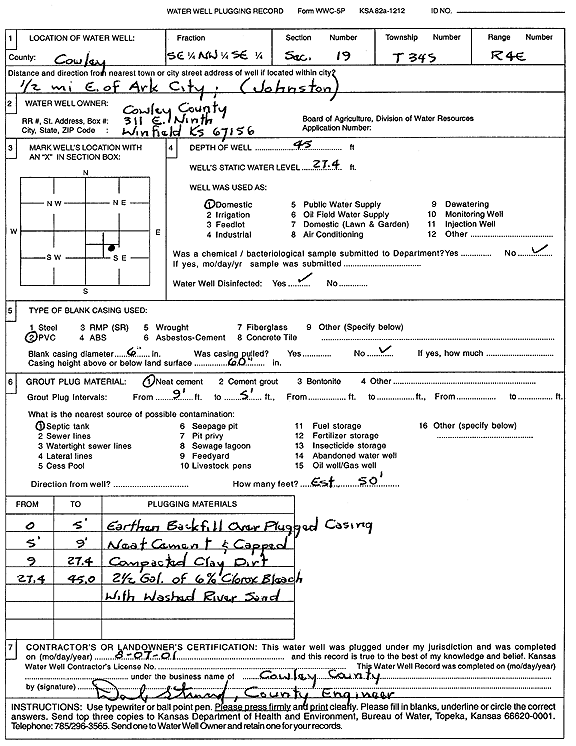
T34S, R4E, Sec. 19 SE NW SE |
Cowley County | 45 ft. | 27.4 ft. | Domestic | Plugged | 07-Aug-2001 | Scan | ||
|
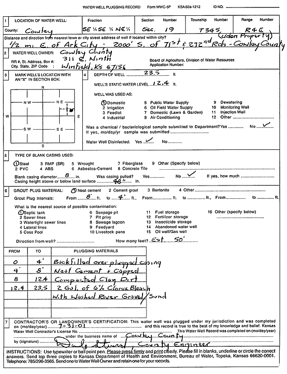
T34S, R4E, Sec. 19 SE SE NE |
Cowley County | 23.5 ft. | 12.4 ft. | Domestic | Plugged | 31-Jul-2001 | Scan | ||
|
T34S, R4E, Sec. 19 NE NW SW |
Cupples, C.B. | 45 ft. | 4 ft. | Domestic, Lawn and Garden | Constructed | 16-Aug-1996 | Scan | ||
|
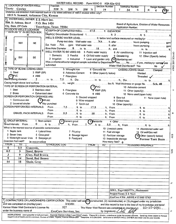
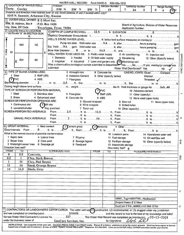
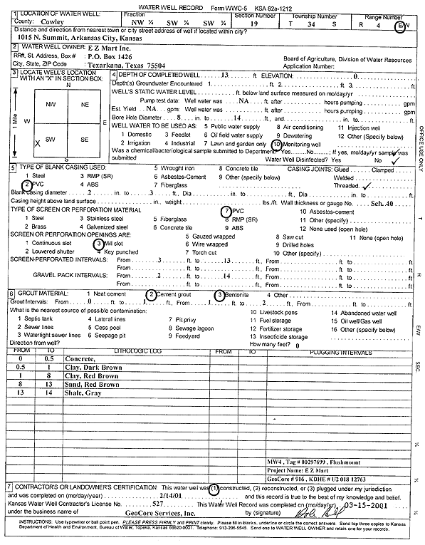
T34S, R4E, Sec. 19 NW SW SW |
E Z Mart Inc | 17.5 ft. | Monitoring well/observation/piezometer | MW 1 | Constructed | 13-Feb-2001 | Scan | ||
|
T34S, R4E, Sec. 19 SW SW NW NW |
El Paso Remediation Company | 15 ft. | 8.91 ft. | Monitoring well/observation/piezometer | MW 14 | Constructed | 22-Apr-2020 | ||
|
T34S, R4E, Sec. 19 NW SW SW |
EZ Mart Inc | 17.5 ft. | Monitoring well/observation/piezometer | MW 1 | Plugged | 28-Sep-2004 | |||
|
T34S, R4E, Sec. 19 NW SW SW |
EZ Mart Inc | 13 ft. | Monitoring well/observation/piezometer | MW 4 | Plugged | 28-Sep-2004 | |||
|
T34S, R4E, Sec. 19 NW SW SW |
EZ Mart Inc | 12.5 ft. | Monitoring well/observation/piezometer | MW 5 | Plugged | 28-Sep-2004 | |||
|
T34S, R4E, Sec. 19 NW SW SW |
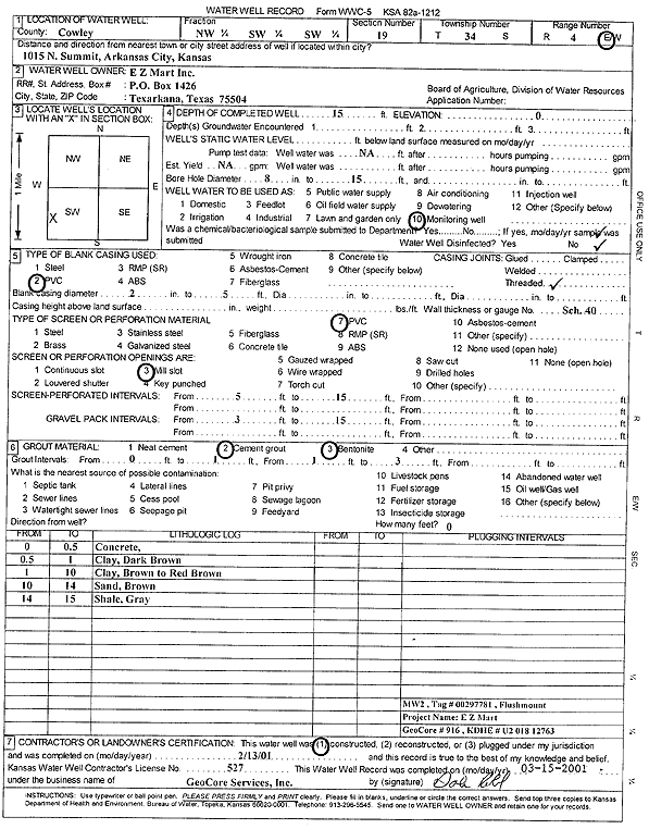
EZ Mart Inc | 15 ft. | Monitoring well/observation/piezometer | MW 2 | Constructed | 13-Feb-2001 | Scan | ||
|
T34S, R4E, Sec. 19 NW SW SW |
EZ Mart Inc | 15 ft. | Monitoring well/observation/piezometer | MW 2 | Plugged | 28-Sep-2004 | |||
|
T34S, R4E, Sec. 19 NW SW SW |
EZ Mart Inc | 12.5 ft. | Monitoring well/observation/piezometer | MW 5 | Constructed | 14-Feb-2001 | Scan | ||
|
T34S, R4E, Sec. 19 NW SW SW |
EZ Mart Inc | 13 ft. | Monitoring well/observation/piezometer | MW 4 | Constructed | 14-Feb-2001 | Scan | ||
|
T34S, R4E, Sec. 19 NW SW NW |
Johnson, Charles | 18.63 ft. | 11.13 ft. | Monitoring well/observation/piezometer | MW 1 | Plugged | 23-Mar-2005 | ||
|
T34S, R4E, Sec. 19 NW SW NW |
Johnson, Charles | 16.8 ft. | 9.74 ft. | Monitoring well/observation/piezometer | MW 3 | Plugged | 23-Mar-2005 | ||
|
T34S, R4E, Sec. 19 NW SW NW |
Johnson, Charles | 17.51 ft. | 10.29 ft. | Monitoring well/observation/piezometer | MW 2 | Plugged | 23-Mar-2005 | ||
|
T34S, R4E, Sec. 19 NW SW SW |
KDHE | 39.5 ft. | 18.6 ft. | Monitoring well/observation/piezometer | MW 4 | Constructed | 02-Sep-1992 | ||
|
T34S, R4E, Sec. 19 NW SW SW |
KDHE | 40 ft. | 17.2 ft. | Monitoring well/observation/piezometer | MW 3 | Constructed | 02-Sep-1992 | ||
| View page: < Prev || 31 || 32 || 33 || 34 || 35 || 36 || 37 || 38 || 39 || 40 || Next > | |||||||||