Select location of well to view details.
Click on column heading to sort.
|
|
|
County: Cowley Select location of well to view details. Click on column heading to sort. |
|
|
|
| View page: < Prev || 31 || 32 || 33 || 34 || 35 || 36 || 37 || 38 || 39 || 40 || Next > | |||||||||
| T-R-S | Owner | Well Depth Ascend. Desc. |
Static Water Level Ascend. Desc. |
Est. Yield Ascend. Desc. |
Well Use | Other ID | Action Taken | Completion Date Ascend. Desc. |
Scan? |
|
T34S, R4E, Sec. 19 SE NW SE |
Riley, L F | 40 ft. | 15 ft. | Domestic, Lawn and Garden | Constructed | 04-Jun-1998 | |||
|
T34S, R4E, Sec. 19 SE NW SE |
Riley, L F | 40 ft. | 15 ft. | Domestic, Lawn and Garden | Constructed | 04-Jun-1998 | |||
|
T34S, R4E, Sec. 19 NE SW NE |
Squires, Danny | 30 ft. | 12 ft. | Domestic | Constructed | 15-May-1978 | |||
|
T34S, R4E, Sec. 20 NE SE SE |
KDHE | 42.5 ft. | 20.1 ft. | Monitoring well/observation/piezometer | MW 5 | Constructed | 02-Sep-1992 | ||
|
T34S, R4E, Sec. 20 NE SE SE |
KDHE | 39 ft. | 18.4 ft. | Monitoring well/observation/piezometer | MW 1 | Constructed | 01-Sep-1992 | ||
|
T34S, R4E, Sec. 20 NE SE SE |
KDHE | 39.5 ft. | 17.1 ft. | Monitoring well/observation/piezometer | MW 2 | Constructed | 01-Sep-1992 | ||
|
T34S, R4E, Sec. 20 NW NW SW |
KDOT | 23 ft. | 17 ft. | Domestic | Plugged | 08-Sep-1995 | |||
|
T34S, R4E, Sec. 20 NW NW SW |
KDOT | 48 ft. | 18 ft. | Domestic | Plugged | 08-Sep-1995 | |||
|
T34S, R4E, Sec. 21 SE SE NE |
KDOT | 57 ft. | 7 ft. | Domestic | Plugged | 08-Sep-1995 | |||
|
T34S, R4E, Sec. 25 SW NE NE |
Clark, T E | 32 ft. | 20 ft. | 2 gpm. | Irrigation | Constructed | 01-Apr-1976 | ||
|
T34S, R4E, Sec. 29 NW NE SW |
Total Refinery | 17.5 ft. | 11.34 ft. | Monitoring well/observation/piezometer | ET 2 | Constructed | 04-Feb-1994 | ||
|
T34S, R4E, Sec. 29 NE SE SE |
Valyer, Dick | 45 ft. | Domestic, Lawn and Garden | Plugged | 08-May-1989 | ||||
|
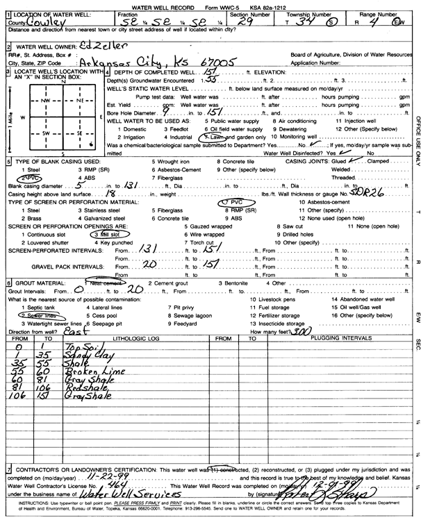
T34S, R4E, Sec. 29 SE SE SE |
Zeller, Ed | 151 ft. | Domestic, Lawn and Garden | Constructed | 22-Nov-1999 | Scan | |||
|
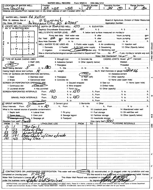
T34S, R4E, Sec. 29 SE SE SE |
Zeller, Ed | 150 ft. | Domestic, Lawn and Garden | Constructed | 22-Nov-1999 | Scan | |||
|
T34S, R4E, Sec. 30 SW SW SE |
Apco East and Bait | 20 ft. | 13.89 ft. | Monitoring well/observation/piezometer | MW 10 | Constructed | 18-Jan-1994 | ||
|
T34S, R4E, Sec. 30 SW SW SE |
Apco East and Bait | 23 ft. | 16.45 ft. | Monitoring well/observation/piezometer | MW 2 | Constructed | 12-Jan-1994 | ||
|
T34S, R4E, Sec. 30 SW SW SE |
Apco East and Bait | 23 ft. | 17.8 ft. | Monitoring well/observation/piezometer | MW 3 | Constructed | 13-Jan-1994 | ||
|
T34S, R4E, Sec. 30 SW SW SE |
Apco East and Bait | 23 ft. | 15.91 ft. | Monitoring well/observation/piezometer | MW 8 | Constructed | 18-Jan-1994 | ||
|
T34S, R4E, Sec. 30 SW SW SE |
Apco East and Bait | 23 ft. | 17.47 ft. | Monitoring well/observation/piezometer | MW 4 | Constructed | 13-Jan-1994 | ||
|
T34S, R4E, Sec. 30 SW SW SE |
Apco East and Bait | 22 ft. | 13.93 ft. | Monitoring well/observation/piezometer | MW 7 | Constructed | 17-Jan-1994 | ||
|
T34S, R4E, Sec. 30 SW SW SE |
Apco East and Bait | 24 ft. | 17.42 ft. | Monitoring well/observation/piezometer | MW 1 | Constructed | 12-Jan-1994 | ||
|
T34S, R4E, Sec. 30 SE SW SW SE |
KDHE BER | 24.8 ft. | 14.3 ft. | Monitoring well/observation/piezometer | MW 12 | Plugged | 29-Apr-2019 |
KOLAR |
|
|
T34S, R4E, Sec. 30 SW SE SW SE |
KDHE BER | 23.25 ft. | 11.5 ft. | Monitoring well/observation/piezometer | MW 2 | Plugged | 29-Apr-2019 |
KOLAR |
|
|
T34S, R4E, Sec. 30 SW SE SW SE |
KDHE BER | 26.3 ft. | 16.1 ft. | Monitoring well/observation/piezometer | MW 4 | Plugged | 29-Apr-2019 |
KOLAR |
|
|
T34S, R4E, Sec. 30 SE SW SW SE |
KDHE BER | 23.45 ft. | 13.5 ft. | Monitoring well/observation/piezometer | MW 1 | Plugged | 29-Apr-2019 |
KOLAR |
|
|
T34S, R4E, Sec. 30 SE SW SW SE |
KDHE BER | 23 ft. | 14 ft. | Monitoring well/observation/piezometer | MW 3 | Plugged | 29-Apr-2019 |
KOLAR |
|
|
T34S, R4E, Sec. 30 SW NW NW |
Mason Oil Co. | 21.5 ft. | 18.46 ft. | Monitoring well/observation/piezometer | MW 9 | Constructed | 15-Feb-2006 | ||
|
T34S, R4E, Sec. 30 SW NW NW |
Mason Oil Co. | 19.5 ft. | 13.97 ft. | Monitoring well/observation/piezometer | MW 3 | Constructed | 16-Sep-2004 | ||
|
T34S, R4E, Sec. 30 SW NW NW |
Mason Oil Co. | 21 ft. | 16.36 ft. | Monitoring well/observation/piezometer | MW 4 | Constructed | 16-Sep-2004 | ||
|
T34S, R4E, Sec. 30 SW NW NW |
Mason Oil Co. | 20.25 ft. | 18.92 ft. | Monitoring well/observation/piezometer | MW 6 | Constructed | 14-Feb-2006 | ||
|
T34S, R4E, Sec. 30 SW NW NW |
Mason Oil Co. | 20.5 ft. | 19.17 ft. | Monitoring well/observation/piezometer | MW 7 | Constructed | 14-Feb-2006 | ||
|
T34S, R4E, Sec. 30 SW NW NW |
Mason Oil Co. | 20 ft. | 19.02 ft. | Monitoring well/observation/piezometer | MW 8 | Constructed | 15-Feb-2006 | ||
|
T34S, R4E, Sec. 30 SW NW NW |
Mason Oil Co. | 19 ft. | 14.98 ft. | Monitoring well/observation/piezometer | MW 1 | Constructed | 16-Sep-2004 | ||
|
T34S, R4E, Sec. 30 SW NW NW |
Mason Oil Co. | 20 ft. | 17.44 ft. | Monitoring well/observation/piezometer | MW 2 | Constructed | 16-Sep-2004 | ||
|
T34S, R4E, Sec. 30 NW NW NW |
Mason Oil Co. | 20.5 ft. | 17.46 ft. | Monitoring well/observation/piezometer | MW 5 | Constructed | 14-Feb-2006 | ||
|
T34S, R4E, Sec. 30 SW NW NW |
Mason Oil Co. | 20 ft. | 16.5 ft. | Monitoring well/observation/piezometer | MW 10 | Constructed | 15-Feb-2006 | ||
|
T34S, R4E, Sec. 30 SW NW NW |
Mason Oil Co. | 21.5 ft. | Monitoring well/observation/piezometer | MW 11 | Constructed | 15-Feb-2006 | |||
|
T34S, R4E, Sec. 30 SE SE SW SW |
Town & Country Markets | 32.15 ft. | Monitoring well/observation/piezometer | MW 10 | Plugged | 22-Nov-2022 | |||
|
T34S, R4E, Sec. 30 SW SE SW SW |
Town & Country Markets | 38 ft. | Monitoring well/observation/piezometer | MW 1 R | Plugged | 22-Nov-2022 | |||
|
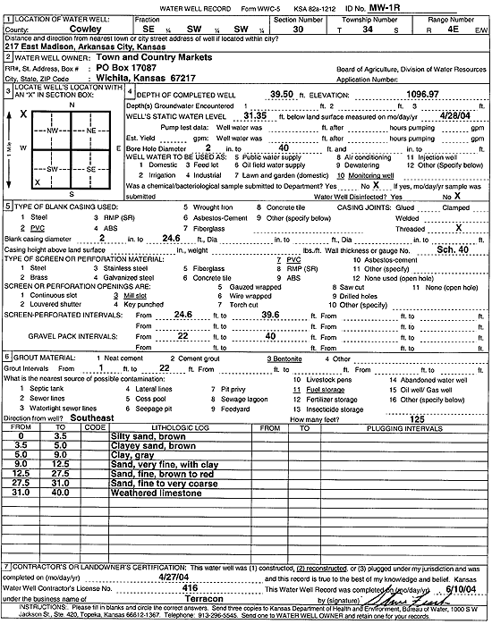
T34S, R4E, Sec. 30 SE SW SW |
Town and Country Markets | 39.5 ft. | 31.35 ft. | Monitoring well/observation/piezometer | MW 1R | Constructed | 27-Apr-2004 | Scan | |
|
T34S, R4E, Sec. 30 SW NE SW |
Two Rivers Coop | 23.82 ft. | Monitoring well/observation/piezometer | MW 4 | Plugged | 09-Jan-2013 | |||
|
T34S, R4E, Sec. 30 SW NE SW |
Two Rivers Coop | 27.9 ft. | Monitoring well/observation/piezometer | MW 1 | Plugged | 09-Jan-2013 | |||
|
T34S, R4E, Sec. 30 SW NE SW |
Two Rivers Coop | 23 ft. | 19.21 ft. | Monitoring well/observation/piezometer | MW 3 | Constructed | 09-Oct-2006 | ||
|
T34S, R4E, Sec. 30 SW NE SW |
Two Rivers Coop | 30 ft. | 17.75 ft. | Monitoring well/observation/piezometer | MW 1 | Constructed | 09-Oct-2006 | ||
|
T34S, R4E, Sec. 30 SW NE SW |
Two Rivers Coop | 22.1 ft. | Monitoring well/observation/piezometer | MW 5 | Plugged | 09-Jan-2013 | |||
|
T34S, R4E, Sec. 30 SE NE SW |
Two Rivers Coop | 26.2 ft. | Monitoring well/observation/piezometer | MW 2 | Plugged | 09-Jan-2013 | |||
|
T34S, R4E, Sec. 30 SE NE SW |
Two Rivers Coop | 27 ft. | 14.91 ft. | Monitoring well/observation/piezometer | MW 2 | Constructed | 09-Oct-2006 | ||
|
T34S, R4E, Sec. 30 SW NE SW |
Two Rivers Coop | 27 ft. | 20.15 ft. | Monitoring well/observation/piezometer | MW 4 | Constructed | 10-Oct-2006 | ||
|
T34S, R4E, Sec. 30 SW NE SW |
Two Rivers Coop | 25 ft. | 14.43 ft. | Monitoring well/observation/piezometer | MW 5 | Constructed | 10-Oct-2006 | ||
|
T34S, R4E, Sec. 30 SW NE SW |
Two Rivers Coop | 22.41 ft. | Monitoring well/observation/piezometer | MW 3 | Plugged | 09-Jan-2013 | |||
| View page: < Prev || 31 || 32 || 33 || 34 || 35 || 36 || 37 || 38 || 39 || 40 || Next > | |||||||||