Select location of well to view details.
Click on column heading to sort.
|
|
|
County: Cowley Select location of well to view details. Click on column heading to sort. |
|
|
|
| View page: < Prev || 31 || 32 || 33 || 34 || 35 || 36 || 37 || 38 || 39 || 40 || Next > | |||||||||
| T-R-S | Owner | Well Depth Ascend. Desc. |
Static Water Level Ascend. Desc. |
Est. Yield Ascend. Desc. |
Well Use | Other ID | Action Taken | Completion Date Ascend. Desc. |
Scan? |
|
T34S, R4E, Sec. 30 SW SW SE |
Ward, Don | 25 ft. | Monitoring well/observation/piezometer | MW 12 | Constructed | 05-Feb-2015 | |||
|
T34S, R4E, Sec. 31 NW NW NE |
Apco East and Bait | 25 ft. | 18.85 ft. | Monitoring well/observation/piezometer | MW 11 | Constructed | 02-Nov-1995 | ||
|
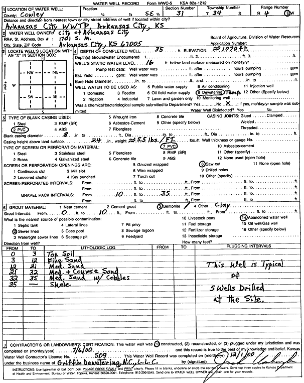
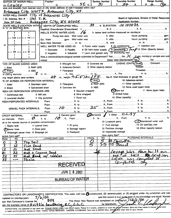
T34S, R4E, Sec. 31 SE SE SE |
City of Arkansas City | 35 ft. | 16 ft. | Dewatering | Constructed | 06-Jul-2000 | Scan | ||
|
T34S, R4E, Sec. 31 SE |
City of Arkansas City | 35 ft. | 16 ft. | Dewatering | Constructed | 06-Jul-2000 | Scan | ||
|
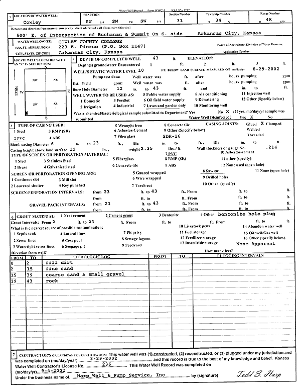
T34S, R4E, Sec. 31 SW SW SW |
Cowley County College | 43 ft. | 10 ft. | Domestic, Lawn and Garden | Constructed | 29-Aug-2002 | Scan | ||
|
T34S, R4E, Sec. 31 SW SW SW |
John Morrell and Co. | 20 ft. | 5.3 ft. | Monitoring well/observation/piezometer | MW 8 | Constructed | 04-Feb-1993 | ||
|
T34S, R4E, Sec. 31 SW SW SW |
John Morrell and Co. | 9.5 ft. | 5.27 ft. | Monitoring well/observation/piezometer | MW 7 | Constructed | 04-Feb-1993 | ||
|
T34S, R4E, Sec. 31 SW SW SW |
John Morrell and Co. | 19 ft. | 10.65 ft. | Monitoring well/observation/piezometer | MW 1 | Constructed | 04-Feb-1993 | ||
|
T34S, R4E, Sec. 31 SW SW SW |
John Morrell and Co. | 23 ft. | 11.71 ft. | Monitoring well/observation/piezometer | MW 2 | Constructed | 04-Feb-1993 | ||
|
T34S, R4E, Sec. 31 NE NW NW NE |
KDHE | 23 ft. | 14.06 ft. | Monitoring well/observation/piezometer | MW 13 | Constructed | 22-Feb-2017 |
KOLAR |
|
|
T34S, R4E, Sec. 31 NE NW NW NE |
KDHE BER | 23.3 ft. | 11.5 ft. | Monitoring well/observation/piezometer | MW 13 | Plugged | 29-Apr-2019 |
KOLAR |
|
|
T34S, R4E, Sec. 31 NE NW NW NE |
KDHE BER | 24.78 ft. | 14.55 ft. | Monitoring well/observation/piezometer | MW 11R | Plugged | 29-Apr-2019 |
KOLAR |
|
|
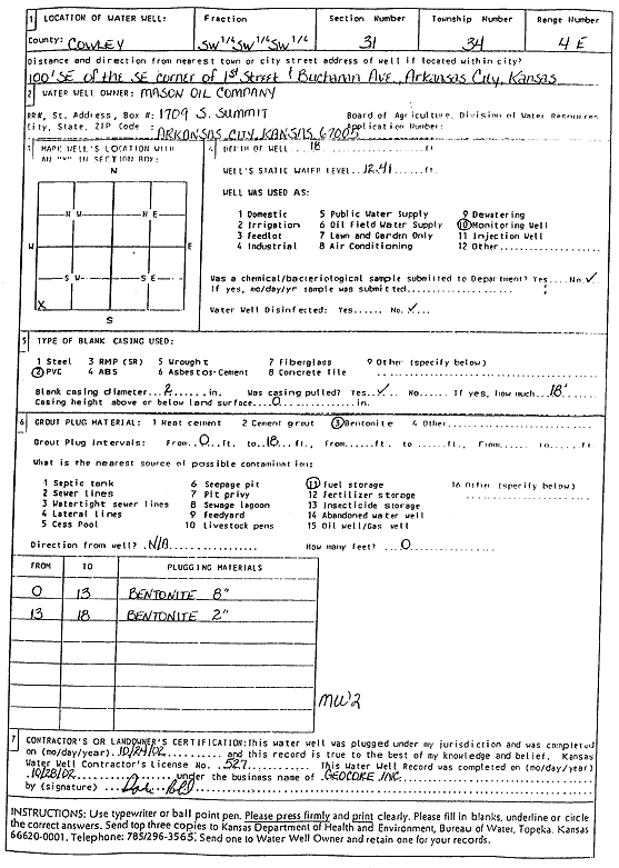
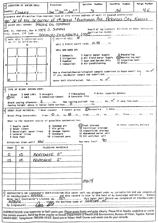
T34S, R4E, Sec. 31 SW SW SW |
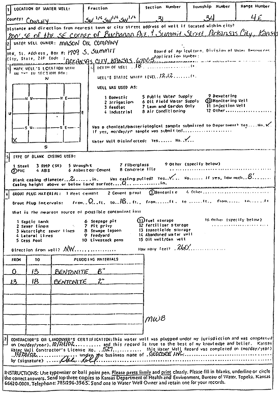
Mason Oil Co. | 18 ft. | 12.41 ft. | Monitoring well/observation/piezometer | MW 2 | Plugged | 24-Oct-2002 | Scan | |
|
T34S, R4E, Sec. 31 SW SW SW |
Mason Oil Co. | 18 ft. | 12.12 ft. | Monitoring well/observation/piezometer | MW 8 | Constructed | 18-Oct-1994 | ||
|
T34S, R4E, Sec. 31 SW SW SW |
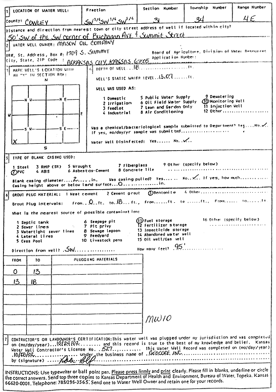
Mason Oil Co. | 18 ft. | 13.07 ft. | Monitoring well/observation/piezometer | MW 10 | Plugged | 24-Oct-2002 | Scan | |
|
T34S, R4E, Sec. 31 SW SW SW |
Mason Oil Co. | 18 ft. | 12.92 ft. | Monitoring well/observation/piezometer | MW 5 | Constructed | 18-Oct-1994 | ||
|
T34S, R4E, Sec. 31 SW SW SW |
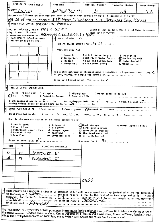
Mason Oil Co. | 17 ft. | 14.21 ft. | Monitoring well/observation/piezometer | MW 3 | Plugged | 24-Oct-2002 | Scan | |
|
T34S, R4E, Sec. 31 SW SW SW |
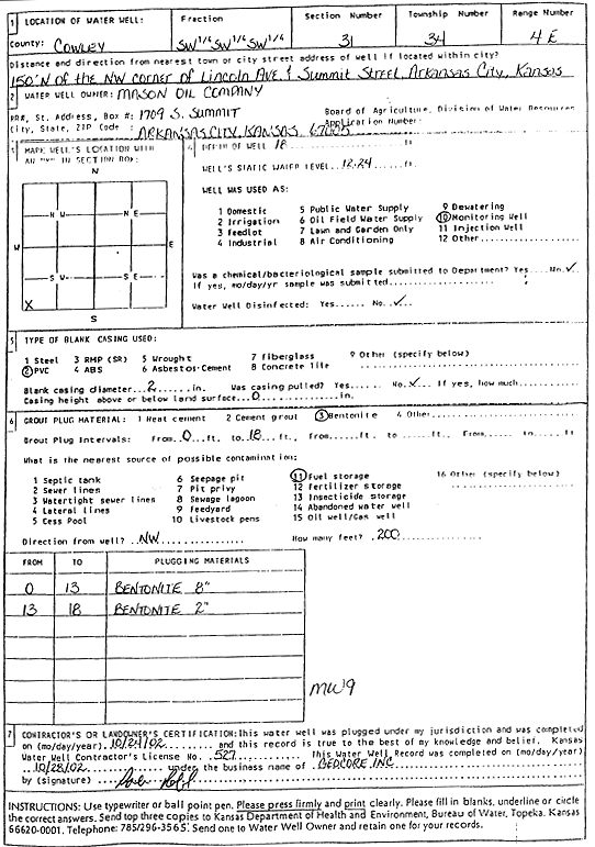
Mason Oil Co. | 18 ft. | 12.24 ft. | Monitoring well/observation/piezometer | MW 9 | Plugged | 24-Oct-2002 | Scan | |
|
T34S, R4E, Sec. 31 SW SW SW |
Mason Oil Co. | 18 ft. | 12.41 ft. | Monitoring well/observation/piezometer | MW 2 | Constructed | 18-Oct-1994 | ||
|
T34S, R4E, Sec. 31 SW SW SW |
Mason Oil Co. | 17 ft. | 14.21 ft. | Monitoring well/observation/piezometer | MW 3 | Constructed | 18-Oct-1994 | ||
|
T34S, R4E, Sec. 31 SW SW SW |
Mason Oil Co. | 18 ft. | 12.58 ft. | Monitoring well/observation/piezometer | MW 4 | Constructed | 18-Oct-1994 | ||
|
T34S, R4E, Sec. 31 SW SW SW |
Mason Oil Co. | 18 ft. | 12.92 ft. | Monitoring well/observation/piezometer | MW 5 | Plugged | 24-Oct-2002 | Scan | |
|
T34S, R4E, Sec. 31 SW SW SW |
Mason Oil Co. | 18 ft. | 12.12 ft. | Monitoring well/observation/piezometer | MW 8 | Plugged | 24-Oct-2002 | Scan | |
|
T34S, R4E, Sec. 31 SW SW SW |
Mason Oil Co. | 18 ft. | Monitoring well/observation/piezometer | MW 10 | Constructed | 18-Oct-1994 | |||
|
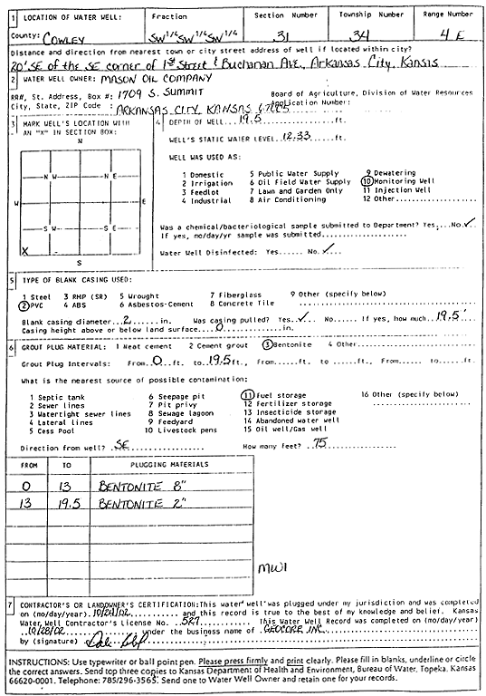
T34S, R4E, Sec. 31 SW SW SW |
Mason Oil Co. | 19.5 ft. | 12.33 ft. | Monitoring well/observation/piezometer | MW 1 | Constructed | 18-Oct-1994 | ||
|
T34S, R4E, Sec. 31 SW SW SW |
Mason Oil Co. | 18 ft. | 12.24 ft. | Monitoring well/observation/piezometer | MW 9 | Constructed | 18-Oct-1994 | ||
|
T34S, R4E, Sec. 31 SW SW SW |
Mason Oil Co. | 18 ft. | 12.58 ft. | Monitoring well/observation/piezometer | MW 4 | Plugged | 24-Oct-2002 | Scan | |
|
T34S, R4E, Sec. 31 SW SW SW |
Mason Oil Co. | 19.5 ft. | 12.33 ft. | Monitoring well/observation/piezometer | MW 1 | Plugged | 24-Oct-2002 | Scan | |
|
T34S, R4E, Sec. 31 NE NE SE |
MRP Properties Co., LLC | 32 ft. | Monitoring well/observation/piezometer | MW 20 C | Constructed | 11-Oct-2013 | |||
|
T34S, R4E, Sec. 31 SE SE NE |
MRP Properties Co., LLC | 42 ft. | 147 gpm. | Environmental Remediation, Recovery | NARW 2 | Constructed | 24-Sep-2008 | ||
|
T34S, R4E, Sec. 31 SE SE SE SE |
MRP Properties Co., LLC | 29.4 ft. | 16.09 ft. | Industrial | Plugged | 11-Apr-2011 | |||
|
T34S, R4E, Sec. 31 NE SE SE |
MRP Properties Co., LLC | 22.37 ft. | 13.63 ft. | Monitoring well/observation/piezometer | MW 41 C | Constructed | 27-May-2014 | ||
|
T34S, R4E, Sec. 31 NE SE SE |
MRP Properties Co., LLC | 22.75 ft. | 15.68 ft. | Monitoring well/observation/piezometer | MW 42 C | Constructed | 27-May-2014 | ||
|
T34S, R4E, Sec. 31 SE SE SE |
MRP Properties Co., LLC | 28.5 ft. | 17.35 ft. | Monitoring well/observation/piezometer | MW 43 C | Constructed | 27-May-2014 | ||
|
T34S, R4E, Sec. 31 SE SE SE SE |
MRP Properties Co., LLC | 25 ft. | 16.81 ft. | Monitoring well/observation/piezometer | MW 48C | Constructed | 01-Mar-2018 |
KOLAR |
|
|
T34S, R4E, Sec. 31 NW SW SE |
Santa Fe Railroad | 23.4 ft. | 19.3 ft. | Monitoring well/observation/piezometer | Constructed | 14-Oct-1992 | |||
|
T34S, R4E, Sec. 31 NW SW SE |
Santa Fe Railroad | 22.5 ft. | 18.5 ft. | Monitoring well/observation/piezometer | Constructed | 14-Oct-1992 | |||
|
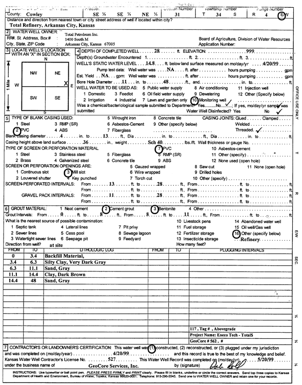
T34S, R4E, Sec. 31 SE SE NE |
Total Petroleum Inc. | 28 ft. | 14.8 ft. | Monitoring well/observation/piezometer | MW 117 | Constructed | 20-Apr-1999 | Scan | |
|
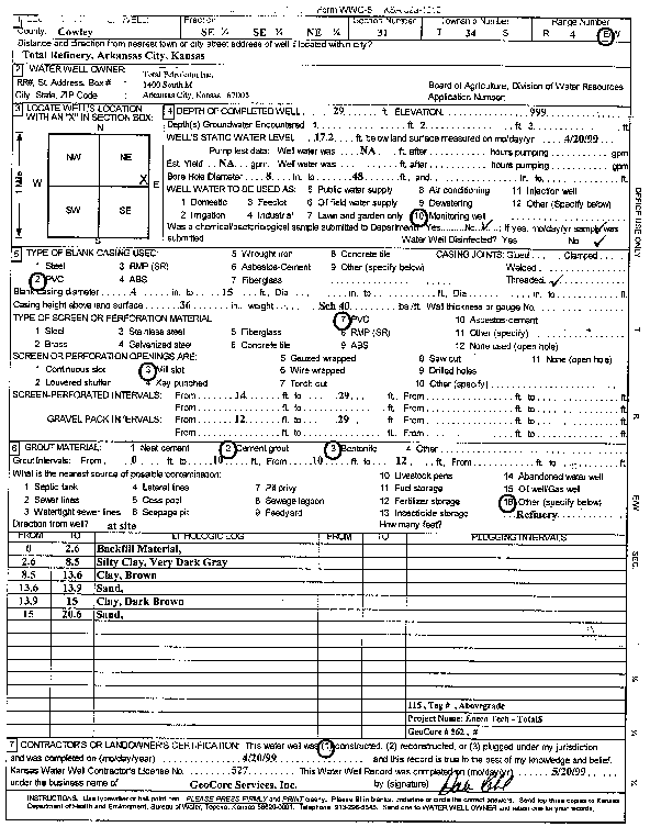
T34S, R4E, Sec. 31 SE SE NE |
Total Petroleum Inc. | 29 ft. | 17.2 ft. | Monitoring well/observation/piezometer | MW 115 | Constructed | 20-Apr-1999 | Scan | |
|
T34S, R4E, Sec. 31 NW NW NW |
Total Petroleum Inc. | 32 ft. | 28 ft. | Monitoring well/observation/piezometer | MW 1 | Constructed | 21-Apr-1995 | ||
|
T34S, R4E, Sec. 31 SE SE SE |
Total Petroleum Inc. | 31 ft. | 15 ft. | 300 gpm. | Industrial | Constructed | 16-Apr-1985 | ||
|
T34S, R4E, Sec. 31 NW NW NW |
Total Petroleum Inc. | 40 ft. | 35 ft. | Monitoring well/observation/piezometer | MW 8 | Constructed | 24-Apr-1995 | ||
|
T34S, R4E, Sec. 31 NW NW NW |
Total Petroleum Inc. | 38 ft. | 34 ft. | Monitoring well/observation/piezometer | MW 9 | Constructed | 24-Apr-1995 | ||
|
T34S, R4E, Sec. 31 NW NW NW |
Total Petroleum Inc. | 32 ft. | 28 ft. | Monitoring well/observation/piezometer | MW 10 | Constructed | 24-Apr-1995 | ||
|
T34S, R4E, Sec. 31 NW NW NW |
Total Petroleum Inc. | 35 ft. | 29 ft. | Monitoring well/observation/piezometer | MW 6 | Constructed | 21-Apr-1995 | ||
|
T34S, R4E, Sec. 31 NW NW NW |
Total Petroleum Inc. | 30 ft. | 27 ft. | Monitoring well/observation/piezometer | MW 5 | Constructed | 24-Apr-1995 | ||
|
T34S, R4E, Sec. 31 NW NW NW |
Total Petroleum Inc. | 31 ft. | 28 ft. | Monitoring well/observation/piezometer | MW 11 | Constructed | 25-Apr-1995 | ||
|
T34S, R4E, Sec. 31 NW NW NW |
Total Petroleum Inc. | 29 ft. | 27 ft. | Monitoring well/observation/piezometer | MW 7 | Constructed | 24-Apr-1995 | ||
|
T34S, R4E, Sec. 31 NW NW NW |
Total Petroleum Inc. | 32 ft. | Monitoring well/observation/piezometer | MW 2 | Constructed | 20-Apr-1995 | |||
|
T34S, R4E, Sec. 31 SE SE SE |
Total Petroleum Inc. | 28 ft. | 12 ft. | Industrial | D 6 | Plugged | 26-Jan-1987 | ||
| View page: < Prev || 31 || 32 || 33 || 34 || 35 || 36 || 37 || 38 || 39 || 40 || Next > | |||||||||