Select location of well to view details.
Click on column heading to sort.
|
|
|
County: Cowley Select location of well to view details. Click on column heading to sort. |
|
|
|
| View page: < Prev || 41 || 42 || 43 || 44 || 45 | |||||||||
| T-R-S | Owner | Well Depth Ascend. Desc. |
Static Water Level Ascend. Desc. |
Est. Yield Ascend. Desc. |
Well Use | Other ID | Action Taken | Completion Date Ascend. Desc. |
Scan? |
|
T34S, R5E, Sec. 6 SE SW NE |
Rozenquist, Niel | 190 ft. | 25 ft. | 2 gpm. | Domestic | Constructed | 15-Jul-2004 | ||
|
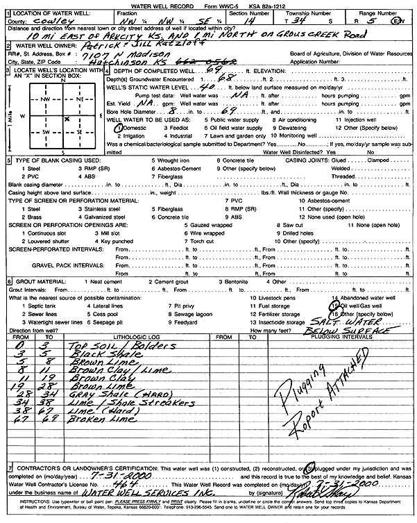
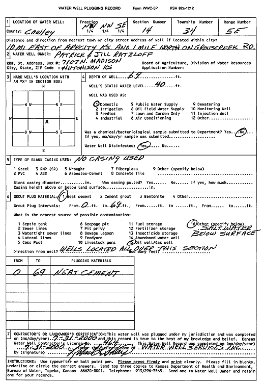
T34S, R5E, Sec. 14 NW NW SE |
Ratzloff, Patrick and Jill | 69 ft. | 40 ft. | Domestic | Plugged | 31-Jul-2000 | Scan | ||
|
T34S, R5E, Sec. 14 NW NW SE |
Ratzloff, Patrick and Jill | 69 ft. | 40 ft. | Domestic | Plugged | 31-Jul-2000 | Scan | ||
|
T34S, R5E, Sec. 14 NE NE SE |
Waldschmidt, Steven and Katie | 100 ft. | 25 ft. | 40 gpm. | Domestic | Constructed | 20-Jul-2022 |
KOLAR |
|
|
T34S, R5E, Sec. 19 NE SW SE |
Dunafon, Beth | 230 ft. | 100 ft. | 1.2 gpm. | Domestic | Constructed | 12-Feb-2026 |
KOLAR |
|
|
T34S, R5E, Sec. 22 NE NW SE NE |
Black, Roger | 18.5 ft. | 14.5 ft. | Domestic | Plugged | 04-Feb-2009 | |||
|
T34S, R5E, Sec. 25 SE SE SE |
Furnace, Lee | 100 ft. | Test hole/well | Test 2 | Plugged | 30-May-1979 | |||
|
T34S, R5E, Sec. 25 SE SE SE |
Furnace, Lee | 55 ft. | Test hole/well | Test 1 | Plugged | 29-May-1979 | |||
|
T34S, R6E, Sec. 7 C SW |
Hardy, Ruth | 42 ft. | 22 ft. | 100 gpm. | Domestic | Constructed | 15-Jul-1985 | ||
|
T34S, R6E, Sec. 9 NE NW SW |
Biaggi, James | 127 ft. | 10 ft. | .5 gpm. | Domestic | Constructed | 29-Dec-2022 |
KOLAR |
|
|
T34S, R6E, Sec. 28 NW NW NW |
Jordan, John | 190 ft. | 45 ft. | 1.75 gpm. | Domestic | Constructed | 19-Mar-2026 |
KOLAR |
|
|
T34S, R7E, Sec. 6 NW SW SW |
Crow, James | 100 ft. | 15 ft. | .5 gpm. | Domestic | Well 2 | Constructed | 26-Jun-2021 |
KOLAR |
|
T34S, R7E, Sec. 6 NE SW SW |
Crow, James | 100 ft. | 33 ft. | .5 gpm. | Domestic, Lawn and Garden | Well 1 | Constructed | 25-Jun-2021 |
KOLAR |
|
T34S, R8E, Sec. 18 NW NE SE NW |
Clapp, Trey | 200 ft. | Geothermal, Closed Loop, Vertical | Constructed | 02-Feb-2014 |
KOLAR |
|||
|
T35S, R3E, Sec. 1 NE NE |
Cherokee Strip Land Rush Museum | 65 ft. | 58 ft. | 15 gpm. | Domestic, Lawn and Garden | Constructed | 19-Dec-2013 | ||
|
T35S, R3E, Sec. 3 NE NE NE |
Russell, Bill | 65 ft. | 38 ft. | Domestic | Constructed | 21-Jul-1978 | |||
|
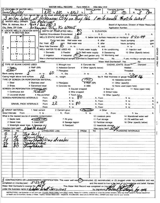
T35S, R3E, Sec. 5 NE NE NW |
Metzinger, Tom | 80 ft. | 20 ft. | 25 gpm. | Domestic, Lawn and Garden | Constructed | 22-May-1998 | Scan | |
|
T35S, R3E, Sec. 10 SE SW SE SW |
Irons, Darren | 67 ft. | 20 ft. | 200 gpm. | Irrigation | Constructed | 17-Mar-2017 |
KOLAR |
|
|
T35S, R3E, Sec. 10 SW SE SE SW |
Irons, Darren | 66 ft. | 20 ft. | 150 gpm. | Irrigation | Constructed | 17-Mar-2017 |
KOLAR |
|
|
T35S, R3E, Sec. 10 NW SE SE SW |
Irons, Darren | 67 ft. | 20 ft. | 200 gpm. | Irrigation | Constructed | 17-Mar-2017 |
KOLAR |
|
|
T35S, R3E, Sec. 10 SE SE SE SW |
Irons, Darren | 66 ft. | 20 ft. | 200 gpm. | Irrigation | Constructed | 17-Mar-2017 |
KOLAR |
|
|
T35S, R3E, Sec. 11 NE NE SE |
Ternes, Kevyn and Wendy | 180 ft. | 25 ft. | 9 gpm. | Domestic, Lawn and Garden | Constructed | 11-Oct-2022 |
KOLAR |
|
|
T35S, R3E, Sec. 13 SW NE SE NE |
Mosier, Roger | 54 ft. | 10.5 ft. | Domestic | Plugged | 17-Feb-2009 | |||
|
T35S, R3E, Sec. 15 SW SE SE |
DeWeese, Mrs. Carl | 41 ft. | 30 ft. | 11 gpm. | Domestic | Constructed | 14-May-2012 | ||
|
T35S, R3E, Sec. 17 NE NE NE |
Ramsey, William | 23 ft. | 5 ft. | Domestic | Plugged | 21-Aug-2001 | Scan | ||
|
T35S, R4E, Sec. 1 SE SE NW |
Cowley County RWD 3 | 29 ft. | 16 ft. | 900 gpm. | Public Water Supply | Constructed | 05-May-1981 | ||
|
T35S, R4E, Sec. 1 C NE NE |
Cowley County RWD 3 | 30 ft. | 10 ft. | 300 gpm. | Public Water Supply | Constructed | 15-May-1976 | ||
|
T35S, R4E, Sec. 3 SW SW NE |
Harper, Don | 80 ft. | Domestic | Plugged | 22-Aug-1987 | ||||
|
T35S, R4E, Sec. 3 NE NE NW |
Kanas Fish and Game Commission | 38.5 ft. | 11 ft. | Pond/Swimming Pool/Recreation | Well 1 | Constructed | 23-Jul-1986 | ||
|
T35S, R4E, Sec. 3 SE SE NW |
Reed, Jim | 162 ft. | 48 ft. | 25 gpm. | Domestic | Constructed | 07-Dec-2023 |
KOLAR |
|
|
T35S, R4E, Sec. 5 NW SW NW |
Lamberton, W. J. | 33 ft. | 15.5 ft. | Industrial | Well 2 | Constructed | 15-Mar-1981 | ||
|
T35S, R4E, Sec. 5 SE SE NW |
Meadows, Bob | 27.5 ft. | 10 gpm. | Domestic | Constructed | 01-Jun-1984 | |||
|
T35S, R4E, Sec. 5 NE NE NW NW |
MRP Properties Company, LLC | 28 ft. | 10.7 ft. | Environmental Remediation, Air Sparge | LTU AS 21 | Plugged | 09-Jun-2017 | ||
|
T35S, R4E, Sec. 5 NE NE NW NW |
MRP Properties Company, LLC | 28 ft. | 12.5 ft. | Environmental Remediation, Air Sparge | LTU AS 20 | Plugged | 09-Jun-2017 | ||
|
T35S, R4E, Sec. 5 NW NW NW |
Total Petroleum Inc. | 39.5 ft. | 19 ft. | Industrial | Well 10 Offset | Constructed | 13-Dec-1991 | ||
|
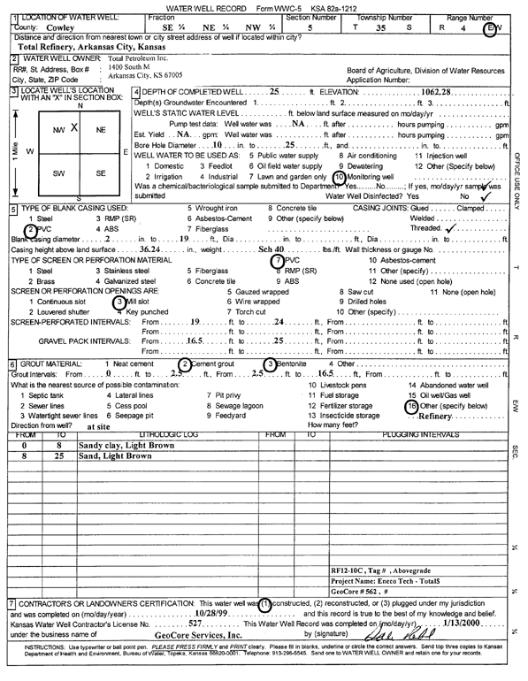
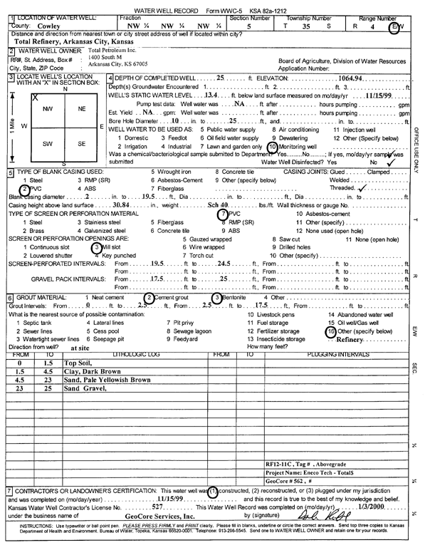
T35S, R4E, Sec. 5 SE NE NW |
Total Petroleum Inc. | 25 ft. | Monitoring well/observation/piezometer | RF 12-10 C | Constructed | 28-Oct-1999 | Scan | ||
|
T35S, R4E, Sec. 5 NW NW NW |
Total Petroleum Inc. | 35.5 ft. | 19 ft. | Industrial | Well 10 | Plugged | 13-Dec-1991 | ||
|
T35S, R4E, Sec. 5 NW NE NW |
Total Petroleum Inc. | 47 ft. | 19.5 ft. | Monitoring well/observation/piezometer | WN 4 A | Constructed | 03-Aug-1988 | ||
|
T35S, R4E, Sec. 5 NE NW NW |
Total Petroleum Inc. | 28 ft. | 18 ft. | Monitoring well/observation/piezometer | WN 1 B | Constructed | 10-Aug-1988 | ||
|
T35S, R4E, Sec. 5 NW NW NW |
Total Petroleum Inc. | 25 ft. | 13.4 ft. | Monitoring well/observation/piezometer | RF 12-11 C | Constructed | 15-Nov-1999 | Scan | |
|
T35S, R4E, Sec. 5 NW NE NW |
Total Petroleum Inc. | 30 ft. | 19.5 ft. | Monitoring well/observation/piezometer | WN 4 B | Constructed | 10-Aug-1988 | ||
|
T35S, R4E, Sec. 5 NE NW NW |
Total Petroleum Inc. | 45 ft. | 18 ft. | Monitoring well/observation/piezometer | WN 1 A | Constructed | 01-Aug-1988 | ||
|
T35S, R4E, Sec. 5 NW NE NW |
Total Petroleum Inc. | 30 ft. | 15.8 ft. | Monitoring well/observation/piezometer | Well 36 | Constructed | 31-Jul-1981 | ||
|
T35S, R4E, Sec. 5 NE NW NW |
Total Petroleum Inc. | 30 ft. | 16.5 ft. | Monitoring well/observation/piezometer | Well 35 | Constructed | 31-Jul-1981 | ||
|
T35S, R4E, Sec. 6 SW SE NE |
Cowley County RWD 1 | 37 ft. | 13 ft. | 450 gpm. | Public Water Supply | Well 6 | Constructed | 03-Oct-1985 | |
|
T35S, R4E, Sec. 6 SE SW NE |
Cowley County RWD 1 | 40 ft. | 15 ft. | Public Water Supply | Well 7 | Constructed | 03-Oct-1985 | ||
|
T35S, R4E, Sec. 6 NE NW NW |
John Morrell and Co. | 22 ft. | 17.4 ft. | Monitoring well/observation/piezometer | MW 4 | Plugged | 25-Aug-2004 | ||
|
T35S, R4E, Sec. 6 NW NW NW |
John Morrell and Co. | 21 ft. | 8.3 ft. | Monitoring well/observation/piezometer | MW 3 | Constructed | 04-Feb-1993 | ||
|
T35S, R4E, Sec. 6 NW NW NW |
John Morrell and Co. | 23.5 ft. | 10.55 ft. | Monitoring well/observation/piezometer | MW 11 | Constructed | 04-Feb-1993 | ||
|
T35S, R4E, Sec. 6 NE NW NW |
John Morrell and Co. | 22 ft. | 13.65 ft. | Monitoring well/observation/piezometer | MW 5 | Plugged | 25-Aug-2004 | ||
| View page: < Prev || 41 || 42 || 43 || 44 || 45 | |||||||||