Select location of well to view details.
Click on column heading to sort.
|
|
|
County: Decatur Select location of well to view details. Click on column heading to sort. |
|
|
|
| View page: 1 || 2 || 3 || 4 || 5 || 6 || 7 || 8 || 9 || 10 || Next > | |||||||||
| T-R-S | Owner | Well Depth Ascend. Desc. |
Static Water Level Ascend. Desc. |
Est. Yield Ascend. Desc. |
Well Use | Other ID | Action Taken | Completion Date Ascend. Desc. |
Scan? |
|
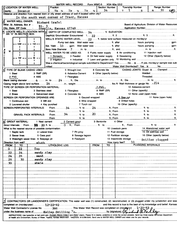
T1S, R30W, Sec. 34 NE NE NE |
Grafel, Richard | 34 ft. | 22 ft. | 10 gpm. | Domestic | Constructed | 22-Dec-1992 | Scan | |
|
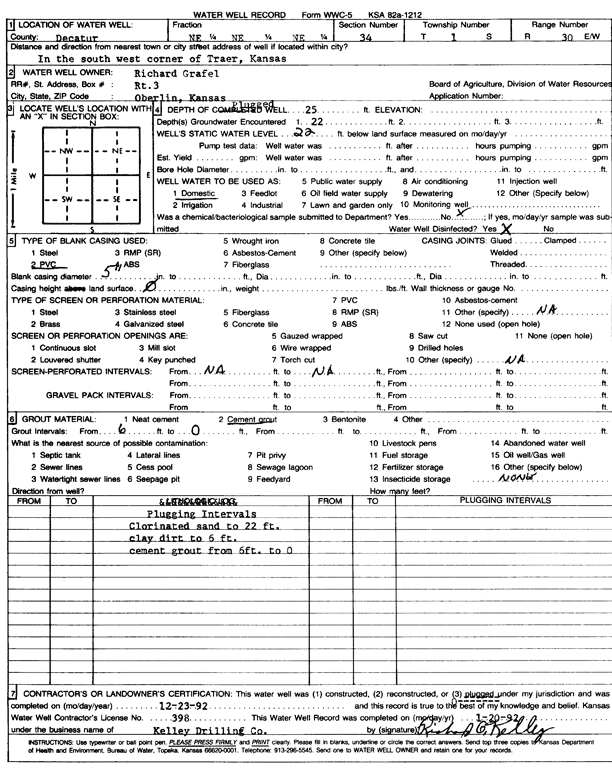
T1S, R30W, Sec. 34 NE NE NE |
Grafel, Richard | 25 ft. | 22 ft. | Domestic | Plugged | 23-Dec-1992 | Scan | ||
|
T1S, R30W, Sec. 34 NE NE NE |
McCleneghan, Sam III | 100 ft. | 58 ft. | Domestic | Constructed | 17-Nov-2008 | |||
|
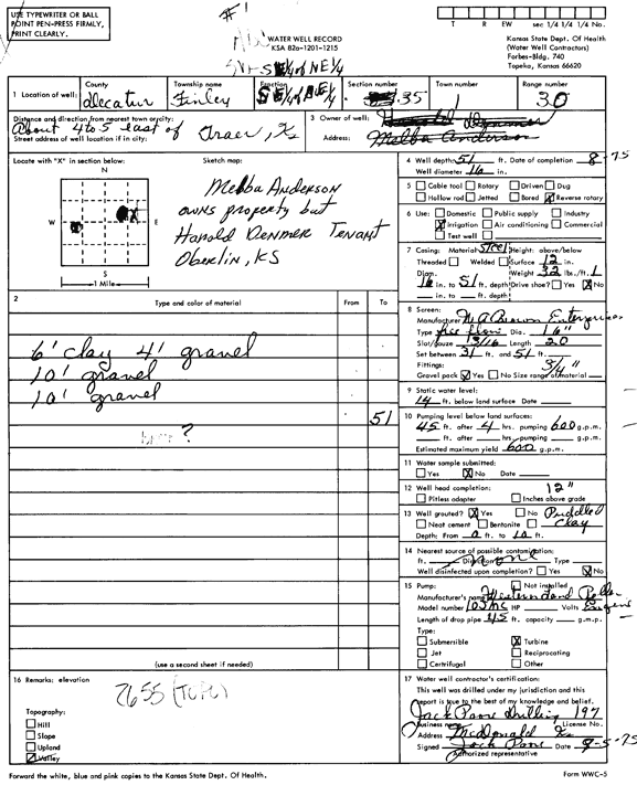
T1S, R30W, Sec. 35 SW SE NE |
Anderson, Melba/Demmer, Harold | 51 ft. | 14 ft. | 600 gpm. | Irrigation | Constructed | 01-Aug-1975 | Scan | |
|
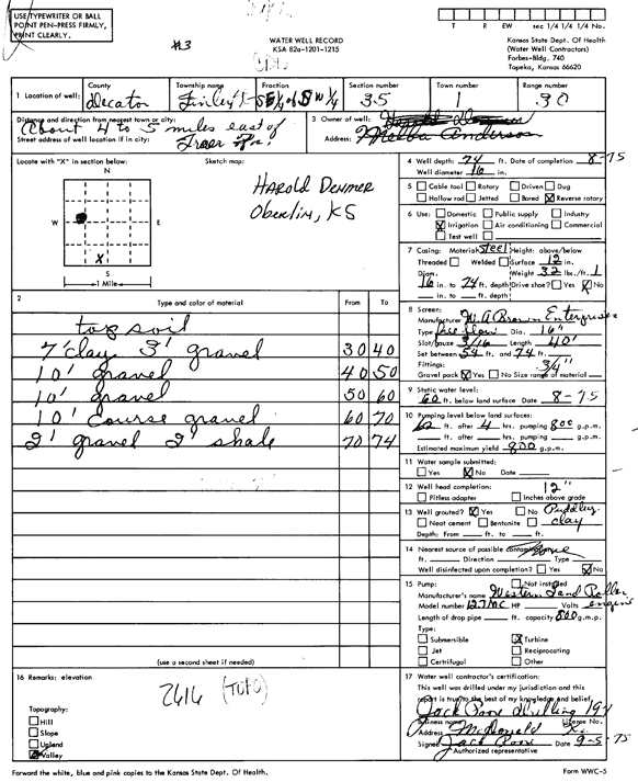
T1S, R30W, Sec. 35 SE SE SW |
Demmer, Harold | 74 ft. | 60 ft. | 800 gpm. | Irrigation | Constructed | 01-Aug-1975 | Scan | |
|
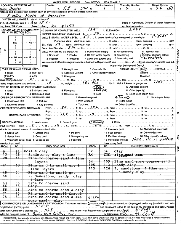
T2S, R26W, Sec. 1 SE SW |
Temple, Ron | 126 ft. | 52 ft. | 10 gpm. | Domestic, Livestock | Constructed | 08-Nov-2001 | Scan | |
|
T2S, R26W, Sec. 4 SW SW NW |
Stapp, Dave | 133 ft. | 110 ft. | 15 gpm. | Domestic, Livestock | Constructed | |||
|
T2S, R26W, Sec. 5 NE SW NE |
Long Branch Farms Inc | 180 ft. | Oil Field Water Supply | Constructed | 20-Oct-2009 | ||||
|
T2S, R26W, Sec. 5 NE SW NE |
Long Branch Farms Inc | 180 ft. | 140 ft. | Oil Field Water Supply | Plugged | 03-Nov-2009 | |||
|
T2S, R26W, Sec. 5 SE NE SW |
Schwab, Bill (was Murfin Drilling) | 175 ft. | Domestic, changed from Oil Field Water Supply | Constructed | 03-Nov-2009 | ||||
|
T2S, R26W, Sec. 5 SE SW NE |
Stapp, Dave | 138 ft. | 123 ft. | 5 gpm. | Domestic | Constructed | 11-May-2006 | ||
|
T2S, R26W, Sec. 6 SE NE SW |
Schwab, Bill | 240 ft. | Oil Field Water Supply | Constructed | 04-Mar-2010 | ||||
|
T2S, R26W, Sec. 6 SE NE SW |
Schwab, Bill | 240 ft. | 132 ft. | Oil Field Water Supply | Plugged | 07-Apr-2010 | |||
|
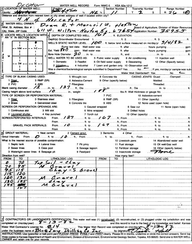
T2S, R26W, Sec. 11 N2 NE |
Haxton, Dean and Marceil | 167 ft. | 100 ft. | 800 gpm. | Irrigation | Constructed | 13-Aug-1982 | Scan | |
|
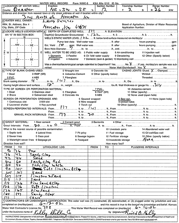
T2S, R26W, Sec. 12 NE SW SE |
Sumner, Larry | 177 ft. | 122 ft. | 10 gpm. | Domestic | Constructed | 12-Jun-2002 | Scan | |
|
T2S, R26W, Sec. 13 NE |
Lawson, Don | 124 ft. | 80 ft. | 15 gpm. | Domestic, Livestock | Constructed | 12-Jun-2005 | ||
|
T2S, R26W, Sec. 14 NE NW NW NE |
Stapp, Dave | 138 ft. | 58 ft. | 50 gpm. | Domestic, Livestock | Constructed | 15-Aug-2016 |
KOLAR |
|
|
T2S, R26W, Sec. 14 NE SW NW |
Stapp, Dave | 197 ft. | 105 ft. | 10 gpm. | Domestic, Livestock | Constructed | 01-Sep-2010 | ||
|
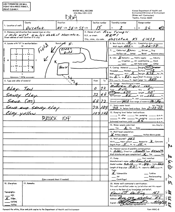
T2S, R26W, Sec. 15 NE SE SE |
Temple, Ron | 105 ft. | 70 ft. | 25 gpm. | Domestic | Constructed | 22-Mar-1978 | Scan | |
|
T2S, R26W, Sec. 15 SE SE NE SE |
Temple, Ron | 98 ft. | 40 ft. | 25 gpm. | Domestic, Lawn and Garden | Constructed | 04-Jun-2013 |
KOLAR |
|
|
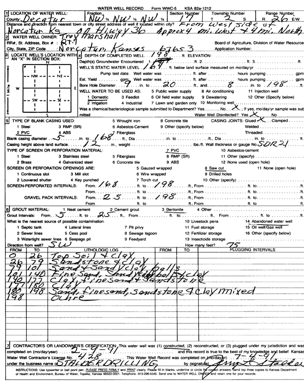
T2S, R26W, Sec. 17 NW NW NW |
Marshall, Troy | 198 ft. | 164 ft. | Domestic | Constructed | 09-Feb-1991 | Scan | ||
|
T2S, R26W, Sec. 18 SE SW SW NW |
Long, Greg | 220 ft. | 180 ft. | 5 gpm. | Domestic, Livestock | Constructed | 28-Nov-2020 |
KOLAR |
|
|
T2S, R26W, Sec. 19 SE SE SE SE |
Hennings Farms | 201 ft. | 160 ft. | 15 gpm. | Domestic, Livestock | Constructed | 03-Feb-2015 |
KOLAR |
|
|
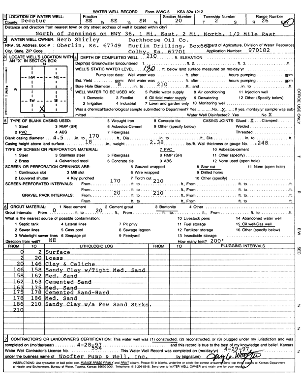
T2S, R26W, Sec. 20 SE SE SW |
Darkhorse Oil Co./Herb Shirley | 210 ft. | 180 ft. | Oil Field Water Supply | Constructed | 28-Apr-1997 | Scan | ||
|
T2S, R26W, Sec. 20 SE NW SE SW |
Henningson, Robbie | 209 ft. | 185 ft. | 10 gpm. | Domestic, Livestock | Constructed | 19-Feb-2014 | ||
|
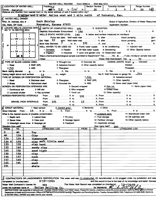
T2S, R26W, Sec. 20 SE SE SW |
Shirley, Herb | 191 ft. | 180 ft. | 10 gpm. | Domestic | Constructed | 19-Aug-1986 | Scan | |
|
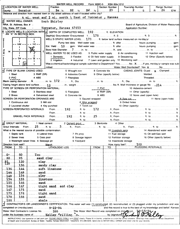
T2S, R26W, Sec. 20 SE SE SW |
Shirley, Herb | 192 ft. | 178 ft. | 10 gpm. | Domestic | Constructed | 22-Sep-1994 | Scan | |
|
T2S, R26W, Sec. 21 NW NW SW |
Jolly, Carl | 200 ft. | Oil Field Water Supply | Constructed | 09-May-2007 | ||||
|
T2S, R26W, Sec. 21 S2 NW |
Stapp, DeWaine | 150 ft. | Oil Field Water Supply | Constructed | 03-Mar-2006 | ||||
|
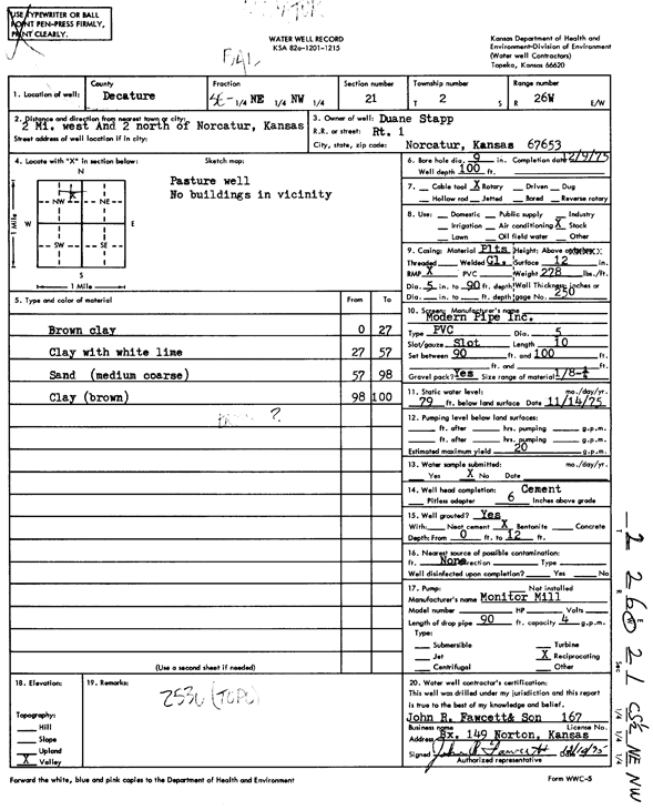
T2S, R26W, Sec. 21 SE NE NW |
Stapp, Duane | 100 ft. | 79 ft. | 20 gpm. | Domestic, Livestock | Constructed | 09-Dec-1975 | Scan | |
|
T2S, R26W, Sec. 21 SE SE SE |
Stapp, Dwayne | 115 ft. | 75 ft. | 10 gpm. | Domestic | Constructed | 03-Jun-1992 | Scan | |
|
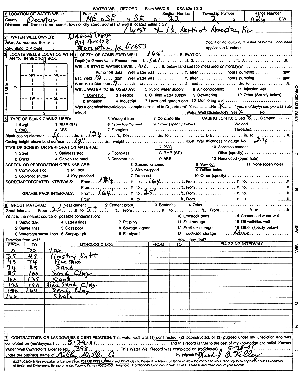
T2S, R26W, Sec. 22 NE SE SE |
Stapp, Dave | 164 ft. | 101 ft. | 10 gpm. | Domestic | Constructed | 24-May-2001 | Scan | |
|
T2S, R26W, Sec. 23 NE NE NW NE |
Wentz, Gaylon | 185 ft. | 100 ft. | 20 gpm. | Domestic, Livestock | Constructed | 28-Aug-2015 |
KOLAR |
|
|
T2S, R26W, Sec. 24 NW NW NE |
Lawson, Don | 198 ft. | 145 ft. | 15 gpm. | Domestic, Livestock | Constructed | 16-Jul-2004 | ||
|
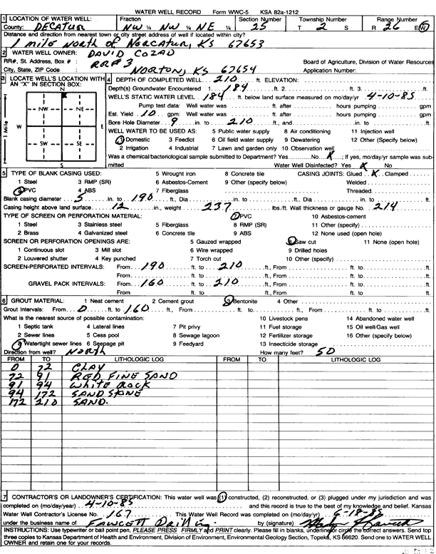
T2S, R26W, Sec. 25 NW NW NE |
Cozad, David | 210 ft. | 184 ft. | 10 gpm. | Domestic | Constructed | 10-Apr-1985 | Scan | |
|
T2S, R26W, Sec. 26 NW NW NW NE |
Hennsinson, Robert | 240 ft. | 180 ft. | 50 gpm. | Oil Field Water Supply | Henningson-Kiser 1-26 | Constructed | 12-Jul-2013 |
KOLAR |
|
T2S, R26W, Sec. 27 SE SW SW |
McVay, Ken or Kathy | 210 ft. | 140 ft. | Domestic | Constructed | 16-Aug-2023 |
KOLAR |
||
|
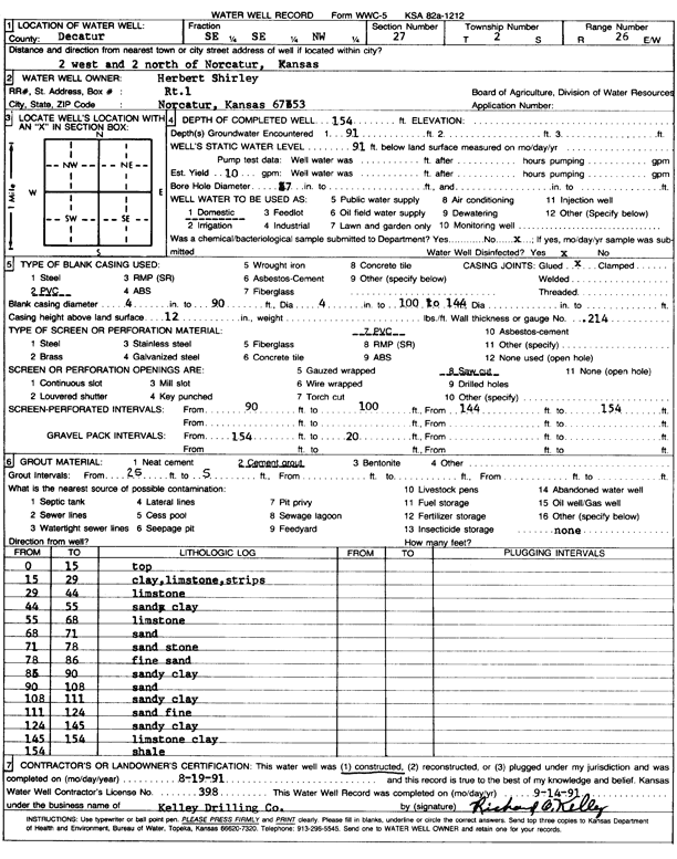
T2S, R26W, Sec. 27 SE SE NW |
Shirley, Herbert | 154 ft. | 91 ft. | 10 gpm. | Domestic | Constructed | 19-Aug-1991 | Scan | |
|
T2S, R26W, Sec. 28 SW NE SW |
Shirley, Herbert | 175 ft. | Oil Field Water Supply | Constructed | 24-Mar-2006 | ||||
|
T2S, R26W, Sec. 28 SW NE SW |
Shirley, Herbert | 175 ft. | 91 ft. | Oil Field Water Supply | Plugged | 18-Mar-2009 | |||
|
T2S, R26W, Sec. 28 SE SW SW SW |
Stapp, Dave | 198 ft. | 138 ft. | 15 gpm. | Domestic, Livestock | Constructed | 25-Apr-2017 | ||
|
T2S, R26W, Sec. 28 NE SW SW |
Stapp, Dave | 185 ft. | 114 ft. | 10 gpm. | Domestic | Constructed | 18-Jan-2022 | ||
|
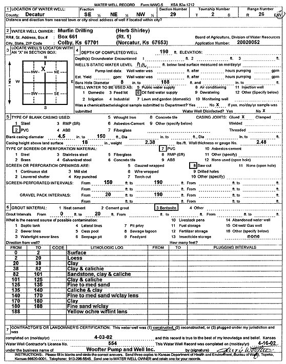
T2S, R26W, Sec. 29 SE NE NW |
Murfin Drilling/Herb Shirley | 190 ft. | Oil Field Water Supply | Constructed | 03-Apr-2002 | Scan | |||
|
T2S, R26W, Sec. 29 NE NE NE |
Shirley, Carol and Herb | 200 ft. | Oil Field Water Supply | Constructed | 03-Jul-2007 | ||||
|
T2S, R26W, Sec. 29 NE NW NE |
Shirley, Herb | 195 ft. | Oil Field Water Supply | Constructed | 14-Jan-2006 | ||||
|
T2S, R26W, Sec. 29 SE NE NW |
Shirley, Herb | 188 ft. | 152 ft. | Oil Field Water Supply | Plugged | 23-Apr-2012 | |||
|
T2S, R26W, Sec. 29 NE SE NE |
Shirley, Herbert | 205 ft. | 158 ft. | Oil Field Water Supply | Constructed | 18-Mar-2009 | |||
|
T2S, R26W, Sec. 29 NE SE NE |
Shirley, Herbert | 205 ft. | Oil Field Water Supply | Constructed | 27-Jul-2006 | ||||
|
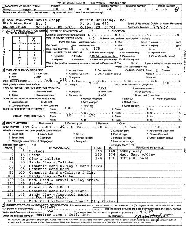
T2S, R26W, Sec. 30 NE NW NE |
Murfin Drilling/David Stapp | 176 ft. | 158 ft. | Oil Field Water Supply | Constructed | 31-Mar-1997 | Scan | ||
|
T2S, R26W, Sec. 31 NE NW NE |
Stites, Wilbur | 200 ft. | Oil Field Water Supply | Constructed | 09-Sep-2000 | Scan | |||
| View page: 1 || 2 || 3 || 4 || 5 || 6 || 7 || 8 || 9 || 10 || Next > | |||||||||